


CCL: https://bit.ly/3Ad8z0O
It’s our hope that each of you, our readers, will enjoy and appreciate this article we present about these 3 Enchanting Marvels of Ethiopia. It was certainly our pleasure to gather the information for you. May it provide you with both education and increased awareness.
Certainly, these formations listed herein represent only a portion of the wonders found throughout this amazing region. It’s our belief, though, that they serve as excellent representations of the marvels found here. Check out some of our other articles, as well.
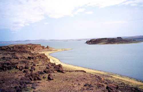
Lake Turkana
CCL: https://bit.ly/3qA6w2x
Lake Turkana Facts
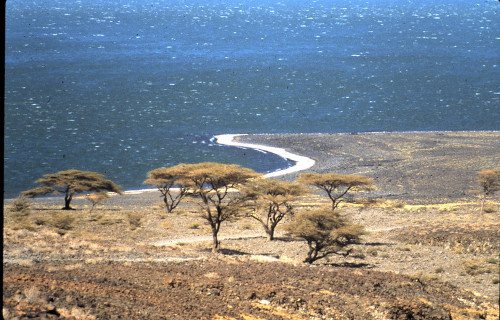
- Leading off this compilation of 3 Enchanting Marvels of Ethiopia we present you with the wonder of geological processes known as Lake Turkana.
- This intriguing creation of geological processes, with its unusual characteristics, presently goes by the english language name used here. It previously held another name, though. Prior to 1975, the body of water bore the moniker of Lake Rudolf.
- The term it’s now known by honors the main tribe of Indigenous Peoples in the region. In their native language, however, it’s long borne their name for it. In that tongue it’s referred to as Anam Ka’alakol. This loosely translates as the sea of many fish.
- The native population knew of the site for untold centuries, of course. European explorers, however, did not see it for the first time until March 6, 1888. At that time, Count Sámuel Teleki de Szék and Lieutenant Ludwig Ritter Von Höhnel spotted it.
- It stands out from similar features around the world for several reasons. It ranks as both the largest alkaline lake and the largest permanent desert lak on earth. The impressive natural wonder further ranks as the fourth largest salt lake known to man.
- Given its unique nature and importance in the region, Lake Turkana merits special consideration. Due to its multi-faceted role in the area, UNESCO named it a World Heritage Site in 1997. Fortunately, it sees few visitors, helping to maintain its condition.
CCL: https://bit.ly/1p2b8Ke
Lake Turkana Physical Description
The magnificent Lake Turkana fully earns appreciation by those experts who monitor it. Unlike many other similar features, though, it does so for a wide variety of reasons. That’s yet another way in which this body of water distinguishes itself in the annals of science.
Its sheer size certainly qualifies as one of those factors, of course. This varies slightly over time, naturally, due to different reasons. In general, though, it boasts a maximum length of about 180 mi (290 km). The lake also holds a maximum width of roughly 20 mi (32 km).
These dimensions understandably bless it with an impressive surface area. That measures approximately 2,473 sq mi (6,405 sq km). It additionally has a maximum measured depth of 358 ft (109 m). Its average depth, though, measures much less, at just 99 ft (30.2 m).
Incredibly, the center of the lake also plays host to an active volcano! Appropriately named Central Island, this site routinely emits quantities of volcanic ash. This activity accounts for and maintains the unusually high levels of alkaline in the water of the surrounding lake.
The water comprising Lake Turkana also holds yet another wonder. Nature, it seems, decided to work overtime in creating this masterpiece. Due to the extreme nature of the site, the water maintains a surprising temperature. This averages between 81F – 88F (27C- 31C).
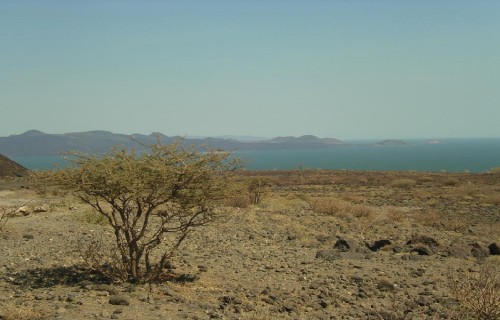
It also hosts a striking outer boundary. That’s partly due to the fact that the surrounding rocks are mainly volcanic in origin. Extremely rocky shores and outcroppings dominate much of the southern and eastern shores. Flats and dunes reign to the west and north.
CCL: https://bit.ly/3qBtUws
Lake Turkana Location, Formation, and Ecology
The area in which the remarkable Lake Turkana formed likely comes as no surprise to many people. That’s true since Nature created it in a region of the world well known for its natural marvels. More precisely, the impressive site lies in an amazing part of the continent of Africa.
Due to its great size, though, it actually formed within the boundaries of two separate countries. The greater part by far sits inside the borders of Kenya. A relatively small portion of it also crosses into neighboring Ethiopia. It’s also a 2-day drive from Nairobi.
This tantalizing geological marvel actually owes its formation and continued presence to a unique combination of factors. Amazingly, a total of three rivers actually flow into the basin where it sits. These themselves bear the names of the Turkwel, Omo, and Keiro Rivers.
That in itself isn’t particularly remarkable, it’s true. What is, though, is the fact that not a single one of them flows out of the lake! The only loss of water the lake suffers occurs due to evaporation. Only the great heat and general aridity of the region maintains a balance.
Due to inaccessibility, temperature, and aridity, Lake Turkana continues to retain its wild character. Nile crocodiles inhabit the lake in abundance, and scorpions and carpet vipers live in numerous around the shores. Hundred of bird species also make this site home.
A wide range of mammals also live around the lake. These include such species as zebras, gazelles, and giraffes. Their predators also appear, including cheetahs and lions. Plankton also lives in its waters. Despite its acidity, this allows a few fish species to thrive as well.
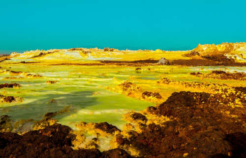
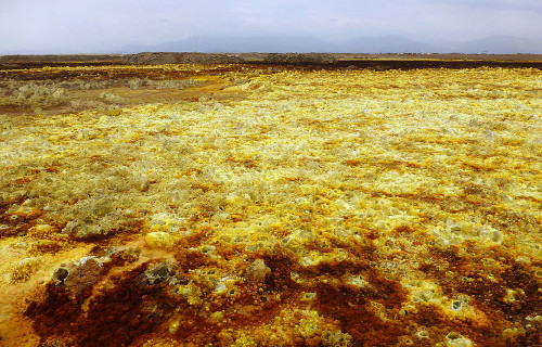
Dallol Hydrothermal Field
CCL: https://bit.ly/3Ad8z0O
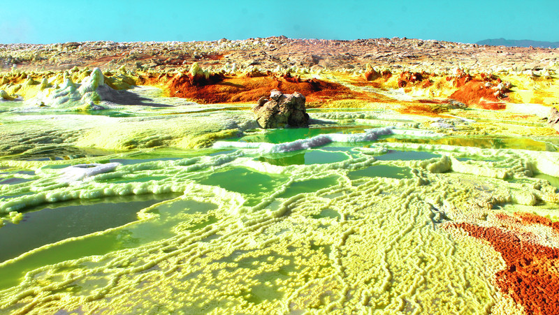
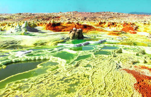
Dallol Hydrothermal Field Facts
- Next up in this article about 3 Enchanting Marvels of Ethiopia is the breathtaking site generally known as the Dallol Hydrothermal Field.
- This breathtaking formation, with its otherworldly vistas, bears the descriptive and informative name for fully obvious reasons. The system forms a truly unique creation of natural forces. No other site exactly like it appears anywhere else on earth.
- It remains unknown how long ago local inhabitants of its region discovered it. European settlers, however, first stumbled upon it during their colonizing expeditions. Though no official record exists, this likely occurred in the 17th or 18th century.
- The very nature of both the site itself and that of the surrounding region precluded extensive exploration at that time, though. Even today, scientific studyof the uniuqe creation of Nature, while ongoing, constitutes a complicated and hazardous procedure.
- Its name derives for the language of the Afar people. They comprise the Indigenous Peoples of the surrounding region. Applied by that group long ago, in their native language the term effectively translates as disintegration or dissolution.
- Not surprisingly, despite its visual splendor, the Dallol Hydrothermal Field does not represent a tourist draw. That provides it with a measure of protection. The wonder of geology nonetheless remains well known for its eerily captivating color patterns.
Dallol Hydrothermal Field Physical Description
The astounding Dallol Hydrothermal Field immediately entrances those who encounter it with its unearthly sights. Despite its many physical marvels, though, its sheer physical size isn’t among them. That’s because Nature packs all its marvels into a small area.
Its outer perimeter underestandably possesses an extremely irregular boundary. In terms of pure area, though, it measures slightly less than 0.4 sq mi (1 sq km). The seemingly preternatural aspects of the world renowned site make it seem far more extensive, however.
These natural marvels also formed around a central feature. That’s the Dallol volcano itself. This feature boasts a relatively broad shape, averaging around 1 mi (1.6 km) in width. In terms of height, it’s quite shallow. In fact, it only measures 164 ft (50 m) in this regard.
The volcanic mountain in the midst of the Dallol Hydrothermal Field garners its own fair share of appreciation. It’s believed that a circular depression near its center represents a collapsed crater. The banks of the mount hold small pillars and fumaroles.
It’s the area surrounding the volcano that hosts its amazing features, though. These include such fabulous sorts as numerous hot springs, brine pools, multicolored sand deposits, miniature geysers, and even pools of acid! It’s truly like stepping onto another world entirely.
CCL: https://bit.ly/2SBqk8X
Dallol Hydrothermal Field Location, Formation, and Geology
The spellbinding Dallo Hydrothermal Field formed in a region of the globe already well known for its natural marvels. In fact, another equally impressive, albeit in a different manner, natural feature, Erta Ale, lies not far to the northeast of this impressive formation.
That’s due to the fact that, like the other aforementioned wonder, it formed on the continent of Africa. Its geographic location places it within the borders of the country of Ethiopia. The remarkable site further resides in the vast region now known as the Danakil Depression.
Evidence indicates that this marvel formed sometime during what geologists know as the Miocene epoch. This places its origins sometime between approximately 23 – 5.3 million years ago. Experts are still unable to determine its date of origin any more precisely.
Its creation originally occurred due to the intrusion of basaltic magma into the salt deposits of the region. The still ongoing hydrothermal activity seems to have begun sometime later. Minor eruptions actually caused the creation of the small volcano recently, in 1926.
The setting crafted by the Dallol Hydrothermal Field is truly unbelievable, unless one sees it for oneself. Many hot springs secrete brine and other acidic compounds continuously. Small, short-lived geysers manifest at random times and places, depositing cones of salt.
It’s doubtless the vibrant colors of the various deposits that garner the most attention, though. Several impurities, including iron, generate the bright brown, ochre, and yellow shades. Oxidation of older deposits often create the darker brown patches present.
Erta Ale
CCL: http://bit.ly/2IjEG4n
Erta Ale Facts
- Closing out this gathering of 3 Enchanting Marvels of Ethiopia comes the otherworldy wonder known simply as Erta Ale.
- The short term applied to it serves as the english language name for this spellbinding creation of naturally occurring geological forces. Like many such incredible features around the globe, it does have another, previously used moniker, though.
- It orgininally bore the name of Irta’ale in the native language of the indigenous population of its region. The commonly used title for the feature translates as smoking mountain. It comes from the native tongue of the local Indigenous People, the Afar.
- Obviously, the original inhabitants of the area have known of its existence for untold centuries. It’s unclear precisely when the first non-natives first spotted it, though. But, reports of sightings by various European explorers date back to the 16th century.
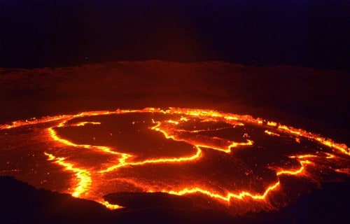
- Those reports, however, only mentioned the volcano itself. The most remarkable individual characteristic of the mountain, though, wasn’t reported until 1960! It’s believed that this, an extraordinary lava lake, formed about 107 years ago.
- Unfortunately, researchers still have only a very limited knowledge of Erta Ale. The terrain in the immediate area remains considered some of the most inhospitable in the world. This makes access to the site both extremely difficult and dangerous.
CCL: https://bit.ly/3jx2c2r
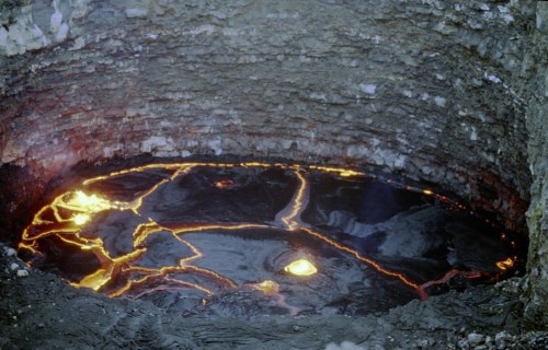
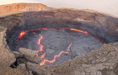
Erta Ale Physical Description
The eerily magnificent Erta Ale is an indescribably unique location. In some ways it’s an utterly unique formation. It therefore draws a great deal of interest for its natural wonders. The site garners such intense interest due to a combination of remarkable aspects.
Though certainly not the tallest volcano currently known to man, it nonetheless boasts a respectable size. In its present state, the mountain stands roughly 2,011 ft (613 m) tall. The base of the impressive formation also has an astonishing diameter measuring 31 mi (50 km)!
The caldera of this natural wonder further holds correspondingly attention-grabbing dimensions. This part of the awesome site’s roughly rectangular in shape. It measures approximately 1 mi (1.6 km) in length. Its width also stands out, at about 0.43 mi (0.7 km).
Simple size isn’t the only tantalizing aspect of the caldera, though. That’s because this itself holds two pit crater within it. Evidence indicates that both of these have often held lava lakes throughout its history. Only seven other volcanoes on earth host such active features.
The largest of the two of these within Erta Ale has a width of roughly 1,148 ft (350 m). It’s also about 656 ft (200 m) deep. The southern of the two ranks as the smaller of the pair. It’s roughly 328 ft (100 m) in depth. The measured diameter equals about 213 ft (65 m).
Though smaller than its companion, it’s by far the most famous. This stands out as the longest continually active feature of its kind known to science. Its longevity and unearthly appearance remain unlike any other. This garnered it the popular name of Gateway to Hell.
CCL: http://bit.ly/2zBWbKi
Erta Ale Location, Formation, and History
The location of the otherwordly creation of time and geological activity known as Erta Ale doesn’t surprise many people. That’s due to the fact that it formed in a part of the world widely known for its natural wonders. Nature provided the region with countless such.
More precisely, the volcanic mountain formed on what’s now known as the continent of Africa. It’s centered over what’s popularly known as the East African Rift. That places it in the Afar Region of northeastern Ethiopia. It also locates it within a local desert.
It’s very formation further distinguishes the mountain from other sites of its kind. That’s due to the fact that it’s the product of a triple junction of tectonic plates. To the present knowledge of geologists, this is the only place on earth where such a conjunction happens.
The movement of these plates creates the forces responsible for its many unique traits. The distinctive mount lies 246 ft (75 m) below sea level, because of the downward thrust of one of the plates. The mountain itself’s comprised of material slowly pushed upward.
Haunting yet captivating Erta Ale holds its share of perils, though, to be certain. Though far less common than its continued slow activity, eruptions do occur sporadically. In August of 2007, a flow escaped the crater, forcing an evacuation of hundreds of local residents.
Explosive eruptions also happen sometimes. In both 2008 and 2017 scientists reported these occurring. The last major eruption took place on September 25, 2005. During this event, thousands of inhabitants fled, two disappeared, and several hundred cattle perished.
3 Enchanting Marvels of Ethiopia
We hope that each of you thoroughly enjoyed reading, and hopefully learning from, this article we’ve written about these 3 Enchanting Marvels of Ethiopia. It’s also our hope that doing so has left you with either a new or renewed appreciation for such wonders of Nature.
Unfortunately, many other such features around the world now find themselves facing threats to their continued existence in an undamaged state. Many of those dangers, in fact, stem from the actions of mankind. We must do all we can to protect and preserve them all.
Check out our other articles on 3 Geological Masterpieces of Virginia, 5 Beautiful North American Butterflies, 7 Captivating Mammals of Canada, 4 Remarkably Evolved Reptiles