


Public Domain Image
It’s our sincere hope that each of you, our readers, will greatly enjoy and appreciate this article we present about these 4 Fabulous Geological Features of Texas. It was certainly our pleasure to gather the information for you. May it provide you with both education and increased awareness.
Certainly, these few formations listed herein represent only a tiny portion of the marvels found throughout this amazing region. It’s our belief, though, that they nonetheless serve as excellent representations of the features found here. Check out some of our other articles, as well.
Rio Grande River
Rio Grande River Facts
- Leading off this article about these 4 Fabulous Geological Features of Texas we present the stunning flow of water known as the Rio Grande River.
- The short yet descriptive term applied to it serves as the most often employed title for this incredible creation of natural forces. Yet, the marvel does have several other general names. These include the very similar tags Rio Bravo and, appropriately, The Great River.
- Still other alternate monikers exist, as well. These include designations such as Rio Grande del Norte. Most typically used within formal and historical context, this one emphasizes its northern course. The term Rio Bravo Grande also exists, blending two of the appellations.
- The Great River, meanwhile, holds its own special place in history and culture. The flow represents an English translation of its name, sometimes used in literature or informal contexts. These tags reflect its history and the many different cultures that interacted with it.
- Ancient Indigenous Peoples long knew of its existence, of course. Archaeological evidence confirms their presence along its course as far back as around 10,800 BCE. Various tribes inhabited locations along its length at different times throughout history, in fact.
- In more modern times, though, the first confirmed sighting of it by outsiders only occurred in the year 1519. At that time, the famed Spanish explorer Álvar Núñez Cabeza de Vaca, part of an expedition led by Pánfilo de Narváez, and his companions sighted the stunning marvel.
- Today, the stunning Rio Grande River earns fully deserved appreciation for its wonders. In its region, it holds the status of a National Wild and Scenic River. Sadly, however, it’s nevertheless highly vulnerable to the perils of human modification and still ongoing climate change.
CCL: https://tinyurl.com/bdes27an
Rio Grande River Physical Description
The magnificent Rio Grande River rarely fails to capture the interest and imagination of those who view this natural wonder. It generally impresses the viewer with its splendor and beauty. Indeed, it does so in a wide variety of ways, like many similar features found around the world.
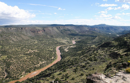
For starters, though, its sheer length certainly qualifies as a point of interest for many. It easily ranks as one of the longest rivers on the continent in which it formed. Though it naturally follows a very winding course, it nevertheless stretches for an impressive length of 1,896 mi (3,051 km).
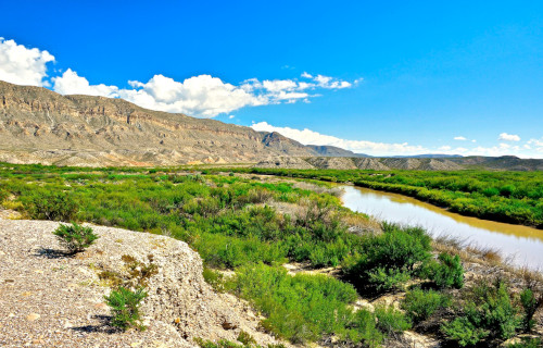
Overall, it follows a roughly southward path. The upper portions of its course flow through steep, narrow canyons and high desert terrain. As the remarkable river moves into other regions, however, it passes through more arid landscapes, including broad desert valleys and low-lying plains.
Its width also varies significantly, especially in diffferent sections. In the Upper Reaches, this ranges from a mere 30 – 100 ft (9.1 – 30 m). Along the Middle Course, though, this averages roughly 100 – 200 ft (30 – 61 m). And finally, the Lower Course averages about 200 – 500 ft (61 – 152 m) across.
Surprisingly, though, despite its width, the Rio Grande River remains relatively shallow. The Upper Reaches only average 2 – 10 ft (0.61 – 3 m) in this regard. The Middle Course just holds a mean depth of 10 – 20 ft (3 – 6.1 m). And lastly, the Lower Course only averages 10 – 30 ft ( 3- 9.1 m).
Even at its deepest point the river only measures about 60 ft (18.3 m) deep. Taken together, however, these various measurements provide the wonder with an impressive discharge rate. Although this naturally varies, of course, it averages a remarkable 2,403 cu ft/s (68 cu m/s).
CCL: https://tinyurl.com/22y23f9m
Rio Grande River Location, Formation, and Ecology
The gorgeous Rio Grande River Formed in a region of the globe already well known for its extreme abundance of natural marvels. That region therefore likely won’t surprise many of you. That’s because the river formed as part of the equally beautiful continent of North America.
This breathtaking flow of water primarily moves through the United States. There, the river begins its journey in southern Colorado, and flows through New Mexico and into Texas. In the latter region, it also forms the natural border between the United States and the country of Mexico.
The formation of this marvel of Nature’s a direct result of complex geological processes that took place over millions of years. These processes involved tectonic activity, volcanic activity, and erosion, all of which strongly contributed to the river’s current course and characteristics.
The Rio Grande Rift is a major feature that played a crucial role in the formation of the river. The rifting began about 30 million years ago. As the crust stretched and thinned, large blocks of the Earth’s crust subsided, creating a series of basins that would eventually channel water flow.
Volcanic activity along the path of its flow also led to the formation of volcanic mountains and lava flows, which further influenced the mighty river’s path. Over time, the erosion of these volcanic and other surrounding materials by wind, water, and ice inexorably shaped the landscape.
Water from precipitation and melting snow began to flow through the valley, gradually forming a channel. The river initially flowed through a series of interconnected basins. Over time, these filled with sediments, and the river cut through them, creating a steady flow to the Gulf of Mexico.
It supports a diverse and complex ecosystem that varies significantly along its length, from its headwaters its mouth. The river also flows through several separate ecological regions, each with distinctly different plant and animal communities, and faces various environmental challenges.
Its upper regions begin in alpine and sub-alpine areas. Vegetation includes coniferous forests, with a wide variety of trees. It also supports species like the Rio Grande cutthroat trout, as well as various amphibians, birds like the bald eagle, and mammals such as mule deer and many black bears.
The Middle Section of the Rio Grande River contains more riparian zones and desert ecosystems. Here, flora includes species like cottonwood trees, mesquite, cresoste, and cactus. Fauna includes birds, beavers, coyotes, bobcats, and even reptiles like the western diamondback rattlesnake.
The Lower Section, however, contains notably more riparian woodlands and coastal ecosystems. Here, the region’s more characterized by dense riparian woodlands, marshes, and coastal plains near its mouth. At this point, some parts even hve an almost sub-tropical environment.
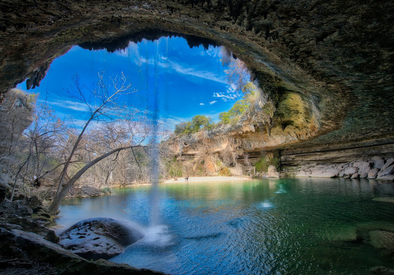
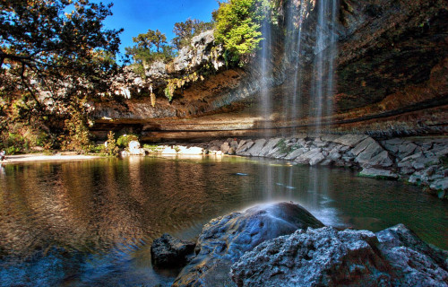
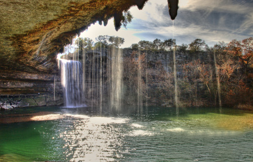
Hamilton Pool
Public Domain Image
Hamilton Pool Facts
- Next up in this compendium of 4 Fabulous Geological Features of Texas comes the breathtaking location simply named Hamilton Pool.
- The short term we’re using represents only one of several names applied to this breathtaking cration of natural geological processes. Others includes such similar titles as Hamilton Pool Preserve, perhaps the most often used of them all, or Hamilton Pool Grotto.
- Regardless of which of these one chooses to use, a surprising fact remains. That’s because, despite its astounding natural beauty, it’s another of those gorgeous sites that still remain virtually unknown outside of its own immediate area. Those who encounter it, though, love it.
- It’s unknown exactly when ancient man first discovered this remarkable feature. Historians do know, however, that local Indigenous Peoples previously utilized the site until the 19th century. Two tribes of the Apache Nation, the Lipan and Tonkawa, both made use of the natural marvel.
- Much later, in the 1860’s, though, the Hamilton family purchased this product of natural creation from the local government, after the departure of the original inhabitants from the region. The family owned it until they decided to sell it to the state in the late 20th century.
- This incredible site also now serves as the cornerstone of the scenic Hamilton Pool Preserve. That legally protected area the state later established in the year 1985. The entire Preserve constitutes a small but gorgeous protected area that covers roughly 232 acres (93.9 ha).
- This status allows for an ongoing restoration of the local ecosystem. In this, its very lack of notoriety serves to aid in its protection against the depredations of mankind. The local officials continue to take every possible caution to preserve and maintain the site in its pristine state.
CCL: https://bit.ly/3dRfOC1
Hamilton Pool Physical Description
The mesmerizing Hamilton Pool almost instantly captivates those fortunate enough to visit this astounding natural formation. It also does so for a large number of reasons. That’s due to the fact that it combines a wide variety of factors into itself, to create a highly unique effect.
The incredible pool itself, the central feature of the location, measures approximately 50 feet in diameter. This structure alos formed with a roughly circular or oval shape. Its generally fresh water also presents a lovely jade green to the naked eye, reflecting the vegetation and limestone around it.
The depth of this stunning natural pool understandably varies in places, but occasionally reaches up to 25 feet in the deeper sections near the center. Its shallower areas around the edge, however, gradually deepen as the adventurous visitor moves toward the middle of the body of water.
The marvel of geology also remains partially covered by a relatively large, curved limestone overhang. This results in the formation of a beautiful natural grotto. Evidence indicates that this overhang formed when part of the underground river system collapsed thousands of years ago.
The grotto’s roof additionally extends about 50 feet over the pool, providing shade and creating a sheltered atmosphere. The ceiling of the grotto’s also adorned with stalactites, and lush green moss often grows on the wet rock surfaces. This only serves to add to the area’s otherworldly beauty.
Amazingly, Nature didn’t simply stop with these marvels when it blessed Hamilton Pool. That’s because, in addition to all the many above-mentioned wonders, the location also hosts a waterfall! This cascades roughly 50 ft (15.2 m) over the edge of the grotto’s overhang in the pool below.
The natural waterfall, in fact, constitues one of the most iconic features of this site. The flow of the cascade varies with the seasons and rainfall, of course. During wet periods, the waterfall tends to be a strong, steady stream, while in drier times, it’s frequently reduced to merely a trickle.
CCL: https://bit.ly/3dTcUfV
Hamilton Pool Location, Formation, and Ecology
The mesmerizing marvel now known as the Hamilton Pool formed in a region of the globe already well known for its abundance of natural geological wonders. The precise location of that site therefore won’t come as any great surprise to anyone. It’s found within part of North America.
Inside of the greater landmass, though, it lies within the boundaries of the United States. There, its picturesque beauty sits approximately 23 mi (37 km) west of the city of Austin, in the state of Texas. That places it in roughly in the south-central part of the state, as the state does in the nation.
Geologists remain uncertain exactly when the site formed, yet believe it happened at least 10,000 years ago. This occurred due to the forces of erosion, working over a vast span of time. However, the dome covering an underground river apparently collapsed at that time, forming the grotto.
Its formation’s a result of natural geological processes common in the Texas Hill Country, particularly the erosion of limestone over time. The area’s karst topography, characterized by sinkholes, caves, and underground streams, contributed to the creation of this stunning feature.
This incredible natural area forms a small yet remarkable oasis in the region, and, as a result, teems with a surprising amount of flora and fauna. The location therefore boasts a rich and diverse ecology, characterized by its unique combination of aquatic, terrestrial, and cave ecosystems.
The one-of-a-kind area’s additionally home to an impressive mix of native plants. This list includes such floral species as bald cypress, sycamore, and oak trees. The grotto itself and the surrounding cliffs also support various ferns, mosses, and numerous other moisture-loving plants.
The upland areas of the preserve where it sits, meanwhile, remain dominated by Ashe juniper, live oak, and various grasses typical of the area. Some plant species in the preserve remain unique to the region due to the specific microclimate created by the grotto and the constant water supply.
The remarkable Hamilton Pool’s also currently a vitally important habitat for several bird species, including the endangered golden-cheeked warbler, which nests in the Ashe juniper woodlands. Other bird species, such as the black-capped vireo, also make their homes at this location.
The value of the pool itself to the local ecosystem doesn’t merely end there, though. That’s because it also supports a variety of aquatic organisms, including fish, amphibians, and invertebrates. The water’s relatively clean, supporting species like minnows and various types of aquatic insects.
A large number of mammals also either live around or near its borders, or make use of its waters. These wonders of Nature include white-tailed deer, raccoons, and armadillos. The greater area of the preserve also hosts various reptiles, including non-venomous snakes, lizards, and turtles.
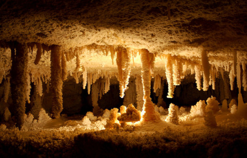
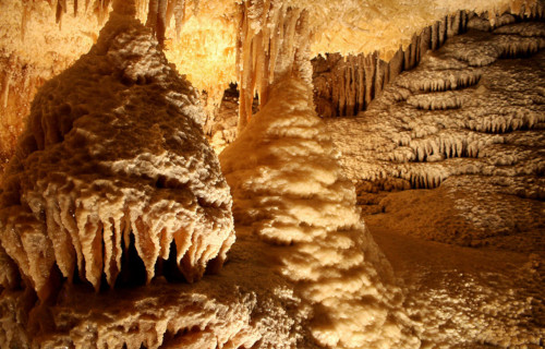
Caverns of Sonora
CCL: https://bit.ly/30wq0tI
Caverns of Sonora Facts
- Our next choice for inclusion in this gathering of 4 Fabulous Geological Features of Texas lies underground, and holds the title of the Caverns of Sonora.
- The term most often applied to this marvel remains a somewhat misleading name for this feature, though that in no way diminishes its awesome nature. In point of fact, the breathtaking site actually constitutes an individual, though in many ways highly impressive, cave.
- In modern times, the magnificent feature first came to the attention of man in the early 1900’s, following its discovery by some local ranch workers. It currently remains unknown if local Native American tribes ever knew of its existence, though this seems quite unlikely.
- The mesmerizing location understandably lists as a world-class cave, due to the abundance and splendor of its many features. As a result, it now holds the status of a National Natural Landmark. With this in mind, the Federal and local governments encourage preservation.
- The mind-boggling Caverns of Sonora nevertheless now constitute a major tourist attraction in its immediate region. As such, it first opened for public tours in 1960. The presence of tour guides and the installation of walkways and railing strives to maintain its condition.
- Sadly, however, prior to these actions, the natural wonder suffered substantial damages from the actions of either inattentive or uncaring explorers. The most tragic such loss was the destruction of part of an ancient natural mineral formation that strongly resembled a butterfly.
CCL: https://bit.ly/30wq0tI
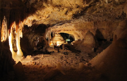
Caverns of Sonora Physical Description
To date, the full dimensions of the fantastic Caverns of Sonora still remain unknown to science, since it’s still being explored. When first discovered, only 2 mi (3.2 km) of the outer portions were known to man. Currently, a total of 7 mi (11.2 km) has been explored and documented.
Scientists eventually expanded the original entrance to the caves, though. That’s because it only represented a tiny opening measuring about 20 in (51 cm). Once inside, however, a marvel of Nature awaits. It’s filled with many narrow passages lined with countless natural features to amaze one.
The hauntingly lovely caverns intriguingly boast an astoundiing abundance of formations, known as stalagmites and stalactites. Both of these structures form from long-term calcium carbonate deposits. Stalactites hang from the ceiling, while the many stalagmites there rise from the ground.
In fact, one particular section of this mind-numbing fairyland remains filled with so many of these, it makes human passage nearly impossible. Locals long ago named this fabulous section of the show cave the snake pit. Most of these also still remain quite actively forming and expanding.
Even more incredible marvels await the intrepid explorer, though. These include amazing features known to experts as helictites. A distinctive feature of this remarkable spot beneath the earth’s surface, these comprise twisted, highly irregularly shaped speleothems that seem to defy gravity.
In other regions, objects called soda straws also appear. These delicate, hollow tubes hang from the ceiling and can grow several feet long. Flowstones, created by flowing water that leaves behind many layers of minerals, also appear as smooth, rippling sheets along the walls and floors.
In yet another part of this wonder of Nature that man continues to explore and discover, still a further amazing feature lies in wait to be seen. Here, comparatively thin, wavy sheets of calcite that supposedly resemble drapes or bacon strips, formed where water trickles down sloped surfaces.
One of the most famous sections of the Caverns of Sonora is named Crystal Palace. It’s with an array of crystal formations that glisten under the lights. A unique feature found in some areas is called moon milk. It’s a white, creamy deposit of calcite possessing a soft, pasty texture.
Still one more miracle of geological forces remains to impress the fortunate visitor, however. That’s the truly massive stalagmites that dominate certain chambers, showcasing the utterly impressive scale of the formations. These many objects collectively bear the name of the White Giants.
CCL: https://bit.ly/2XNbZpU
Caverns of Sonora Location and Formation
The magnificent Caverns of Sonora formed in a general region of the globe already well known for its extraordinary abundance of natural wonders. That area thus won’t surprise many people. That’s because Nature created this marvel as part of what’s now the continent of North America.
There, its precisegeographical location places it within the national borders of the United States. Within that country, it resides inside the state of Texas, which also borders the country of Mexico. Its placement also puts the caverns in the approximate southwestern section of the state.
The overall geological structure within which the incomprehensibly beautiful site resides formed around 100 million years ago. The cave itself, though, actually formed much later. More precisely, scientific evidence indicates that it formed somewhere between 1.5 and 5 million years ago.
Over millions of years, copious amount of rainwater, which absorbs carbon dioxide from the atmosphere and soil to form a weak carbonic acid, infiltrated the ground. This then seeped through cracks and fissures in the limestone. This began weakening it, setting the stage for more actions.
The slightly acidic water slowly dissolved the calcium carbonate in the limestone. This also had the natural effect of slowly enlarging the cracks and fissures to form underground voids and passages. That inexorable action ocurred via a process called chemical weathering or solutional erosion.
These numerous voids and passages gradually expanded over time into ever larger chambers and tunnels, creating the basic structure of the caverns. At this point, though, the gorgeous Caverns of Sonora still did not yet hold the appearance they do today, but it was nonetheless in process.
As the aforementioned acidic water continued to percolate through the limestone and into the caverns, it also carried with it prodigious quantities of dissolved calcium carbonate. When this mineral-rich water reached air-filled voids within the cave, it began to deposit that specific mineral.
The stalactites also formed as water minutely dripped from the ceiling, leaving behind trace amounts of calcite that accumulated over time. Stalagmites, however, conversely formed on the ground below from the dripping water that fell from the stalactites situated above their position.
The helictites themselves originated in an intriguing manner, too. Several natural processes created these irregular, highly twisted formations when water became pushed through tiny capillary tubes located in the rock. That action steadily deposited calcite in seemingly gravity-defying shapes.
The captivating flowstones also formed from sheets of water flowing over walls or floors, leaving behind smooth layers of calcite. Draperies and soda straws developed from water seeping through sloped surfaces or dripping slowly, creating thin, wavy sheets or hollow tubes of calcite.
Caddo Lake
CCL: https://bit.ly/2X8vYgB
Caddo Lake Facts
- Closing out this compilation of these 4 Fabulous Geological Features of Texas is the mind-blowing wonder men typically call Caddo Lake.
- The somewhat intriguing title serves as the most frequently employed common name for this captivating creation of natural processes. Yet, it does have several other general titles. These include such terms as Big Cypress Bayou, Ferry Lake, and Saw Mill Pond, among others.
- Regardless of which of these monikers one chooses to use, the site stands out, both in the minds of many individuals, and officially. Its borders contain one of the largest flooded cypress forests in its region. It’s also one of the few natural non-oxbow lakes in the generally arid area.
- The local Indigenous Peoples long knew of the existence of this stunning natural marvel, of course. Archaeological evidence indicates that the ancestors of the Caddo people, the most recent to inhabit the region, lived in the area for centuries, utilizing the lake and its resources.
- European exploration of the area began in the 18th and early 19th centuries. While there isn’t a single figure credited with discovering the remarkable natural feature, both Spanish and French explorers in the region likely encountered the lake during their various expeditions.
- Its incredible and unique natural beauty and distinctive attributes continue to serve Caddo Lake well today, however. Due to these, the amazing feature now holds several formal distinctions which provide it with a certain degree of protection from the depredations of man.
- The site now represents part of an internationally protected wetland under the Ramsar Convention. It also serves as the linchpin component of the aptly-named Caddo Lake State Park and Wildlife Management Area. Efforts to protect and maintain its pristine state continue.
CCL: https://bit.ly/2qNJUAw
Caddo Lake Physical Description
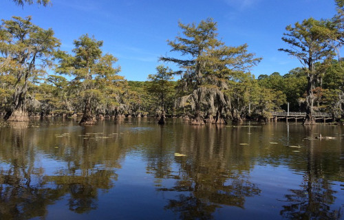
The stunning Caddo Lake presents a remarkable face to visitors that rarely fails to captivate and amaze them. Yet, the awesome creation of Nature does so for more than just one reason. That’s because the wonder boasts both an impressive size and some fascinating individual features.
In terms of the former, though, its dimensions vary, given its unique nature. Overall, however, the main body measures roughly 10 mi (16 km) in length. The variations occur due to the fact that numerous winding bayous, channels, and wetlands that extend beyond its primary boundaries.
Its width also varies widely due to its irregular shape and extensive wetlands. On average, it’s about 3 -4 mi (5 – 6.5 km) wide in its broader sections, though some, especially the bayous and channels, measure much smaller. Its sprawling nature makes its dimensions highly variable in different areas.
These dimensions combine to provide it with a respectable total area. The primary body, not including outlying regions, covers approximately 25,400 acres (10,300 hectares). This makes the unique body of water the largest natural freshwater lake in the local region of the country it’s in.
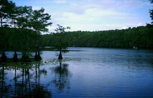
Despite its expansive outward dimensions, though, Caddo Lake isn’t very deep. Its shallower areas average no more than 1 -4 ft (0.3 – 1.2 m). Its deepest, meanwhile, only reach around 20 ft (6 m). Overall, the mean depth of this distinctive, otherworldly site measures about 8 -10 ft (2.4 – 3 m).
Still other marvels await those individuals who choose to visit this fabulous site, however. Nature also blessed the lake with numerous small islands within its confines. Its labyrinthine structure even includes hidden inlets, winding channels, and, in many places, extremely dense tree growth.
CCL: https://bit.ly/2Qertj5
Caddo Lake Location, Formation, and Ecology
The uncommon beauty of Caddo Lake formed in a region of the globe that’s already renowned for its abundance of natural wonders. The awesome feature’s location therefore likely won’t surprise many of you. That’s true since it formed as part of the greater landmass of North America.
More precisely, though, the beautiful wetland lies within the national borders of the United States. Its precise geographical placement puts the feature in the general south-central portion of the country. Coincidentally, it straddles the borders between the states of Louisiana and Texas.
Intriguingly, proposed theories vary as to the precise nature and date of the origin of this incredible wonder. No widely accepted definitive proof exists for any of them at this time, however. Nonetheless, certain of them do presently have more support from scientific evidence than others.
The preponderance of evidence indicates that, beginning sometime during the 12th or 13th century, a massive logjam began forming on the Red River. It further seems that this naturally occurring obstruction persisted for centuries, continuing to build, until cleared between 1833 and 1838.
At its height, just prior to its being cleared, the astounding logjam spanned about 160 mi (257 km). This caused the water to back up into the surrounding lowlands and wetlands, forming the swamp-like environment with slow-moving bayous and sloughs that currently exists today.
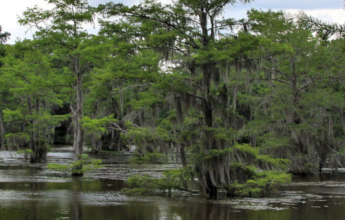
This site represents a highly unique and ecologically rich wetland ecosystem. It’s thus not surprising that it’s also home to a diverse array of plant and animal species. The lake’s combination of swamp, bayou, and open water habitats creates a vibrant and biologically significant environment.
The iconic bald cypress trees, with wide trunks and root structures dominate the landscape. These are well-adapted to the conditions and provide a habitat for many species. Draped from the cypress trees, Spanish moss also adds to the lake’s mystique and provides shelter for small organisms.
This marvel’s additionally filled with numerous aquatic plants such as water lilies, American lotus, duckweed, and cattails. These plants thrive in the shallow waters and help maintain water quality by filtering nutrients and providing habitat for fish and multiple other aquatic organisms.
Caddo Lake also supports a rich variety of fauna. This includes many fish species, including largemouth bass, crappie, catfish, and sunfish. Many amphibians and reptiles also live here, including alligators, turtles such as the alligator snapping turtle, frogs, and various snakes live here.
Birds also thrive here, with more than 200 species either living here or using it as a stopover in their movements. Mammals such as raccoons, beavers, river otters, and white-tailed deer inhabit the area. The dense vegetation and abundant water make the lake an ideal habitat for many animals.
CCL: https://bit.ly/3dRfOC1
4 Fabulous Geological Features of Texas
We hope that each of you thoroughly enjoyed reading, and hopefully learning from, this article we’ve written about these 4 Fabulous Geological Features of Texas. It’s also our hope that doing so has left you with either a new or renewed appreciation for such wonders of Nature.
Unfortunately, many other such features around the world now find themselves facing severe threats to their continued existence in an undamaged state. Many of those dangers, in fact, stem from the actions of mankind. Each of us must do all we can to protect and preserve them all.
Check out our other articles on 3 Beautiful Butterflies of Canada, Clouded Leopard, Sardinia, Socotra Dragon Tree, Autumn Meadowhawk, Weedy Seadragon, Texas Alligator Lizard