


CCL: https://bit.ly/3xliBv3
We sincerely hope that you will thoroughly enjoy this article about 4 Geological Wonders of Canada. Obviously, every part of the world has its natural marvels. But, many people often overlook the marvels of this region of the world. We hope to change that situation.
Furthermore, the natural works of this region come in different forms. In fact, some of them will amaze you with their distinctiveness. No matter what kind of beauty you prefer where geology is concerned, this reason has something for everyone to appreciate.
Pingualuit Crater Lake
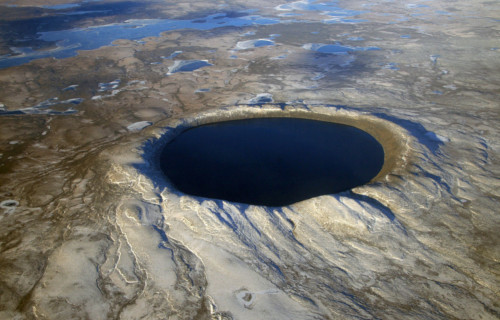
Photo: NASA. Courtesy of Denis Sarrazin
Public Domain Image
Pingualuit Crater Lake Facts
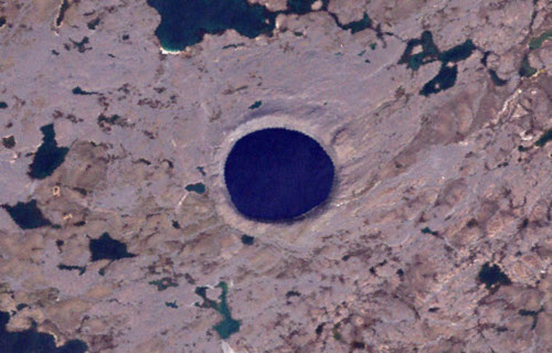
- Leading off his article about 4 Geological Wonders of Canada is the mind-blowing site known as Pingualuit Crater Lake.
- The distinctive term for this site serves as the name of an astonishingly pristine lake. But the site also boasts an incredible history. In point of fact, this fantastic feature actually formed from a meteorite impact nearly 1.4 million years ago.
- As an understandable result, this lake represents a truly amazing geological site. That somewhat bold statement holds true due to several factors. One of its most noteworthy features remains its complete lack of either inlets or outlets.
- To the great surprise of many, the water levels stay maintained entirely by precipitation and evaporation. Further, this cycle happens extremely smoothly and evenly. It also has an incredibly low acidity level in comparison with most other lakes.
- As a result, the water of the awesome Pingualuit Crater Lake remains almost perpetually extraordinarily clear. In fact, this remarkable characteristic has earned it quite a reputation. This lake has been called one of the clearest lakes in the world.
- Finally, the site used to be known by another name entirely, creating some confusion. It formerly bore the name of the Chubb Crater. The name changed to its current one in 1999. Its current name comes from the language of the indigenous Inuit people.

CCL: https://bit.ly/37yA3Qz
Pingualuit Crater Lake Physical Description
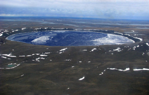
The astounding feature known as Pingualuit Crater Lake fits in perfectly with its surroundings. This landscape itself has been frequently described as lunar. This very state of relative desolation, however, only serves to further highlight the magnificence of the site.
The marvelous location has some very impressive measurements to recommend it. In fact, the incredible crater itself forms an almost perfect circle. It should also be further noted that this crater also measures an astonishing 2.1 mi (3.4 km) in diameter.
Yet its diameter isn’t its only fascinating characteristic. For one, the walls of the crater itself measure roughly 1,300 ft (400 m) high. These walls also rise roughly 521 ft (159 m) above the surrounding terrain. Plus, the beautiful lake itself averages nearly 876 ft (267 m) deep.
Its contents also stand out in many ways. The water contains a salinity level of less than 3 ppm, which actually ranks among the lowest on earth. As a result, the water nearly always appears remarkably clear. Objects as deep as 115 ft (35 m) remain visible to the naked eye.
Public Domain Image
Pingualuit Crater Lake Formation and Mystery
The breathtaking and fascinating Pingualuit Crater Lake formed in a relatively remote portion of the world. More precisely, it appears in a small section of North America. In point of fact, the marvel of Nature can be found on the Ungava Peninsula, in Canada.
The impact that created this astounding formation appears to have occurred approximately 1.4 million years ago. However, its age only serves as the beginning of the surprising facts about the site. That’s because the impact itself also seems to have been unique.
Instead of striking at an angle, as usually happens, the object struck the earth almost perfectly vertically. In an astounding occurrence, a nearly circular crater formed as a result of the impact. Analysis of the rocks indicates the meteorite was of the chondrite type.
As a result of glacial activity during the last ice age, the crater filled with ice. This action occurred over a great period of time. The withdrawal of the ice sheet left the crater itself filled with ice. The lake formed from the melting ice, and now comprises a closed system.
To the amazement of those who learn of Pingualuit Crater Lake, one last mystery remains. That’s due to the fact that a single species of fish inhabits the lake. These have adapted to survive with minimal sources of food. How these came to inhabit the lake remains a mystery.
Prince Edward Island
Prince Edward Island Facts
- Next up among these selections for inclusion in this compendium of 4 Geological Wonders of Canada is the stunning Prince Edward Island.
- The breathtakingly beautiful location known by the royal name ranks as a geological marvel. This occurs due to its sheer natural beauty. But it also remains renowned for its lush agricultural land, as well as its great swathes of pastoral land.
- The truly magnificent island further stands out for another reason. In point of fact, it represents one of the oldest settlements in the country. The remarkable location bears the name of Prince Edward (1767-1820), the father of Queen Victoria.
- Quite unsurprisingly, agriculture forms the principal economy of the island. This amazing island therefore further plays an important economical role. It alone produces roughly 25% of all potatoes grown in the country it forms a part of.
- Finally, the stunning Prince Edward Island also serves as an important location for numerous other industries. Not surprisingly, these include tourism, fishing, aerospace, bio-science, and especially renewable energy research and development.
Prince Edward Island Geology
The province of which Prince Edward Island forms the central component comprises numerous separate parts. That’s due to a comparatively unusual situation for its parent country. That’s the fact that it consists of a main island and 231 minor constituent islands.
Altogether this grouping comprises a moderately impressive total area. More precisely, this combination of sites achieves a total land area measuring about 2,195 sq mi (5,685 sq km). The main island itself, though, measures roughly 2,170 sq mi (5,620 sq km).
Further, the gorgeous Prince Edward Island formed between 250-300 million years ago, occurring during the Permian period. Freshwater streams deposited enormous quantities of gravel, sand, and silt into the region now popular as the Gulf of Saint Lawrence.
In addition, much of the bedrock of the island also principally consists of the distinctive mineral red sandstone. Prior to the enormous glacial melting which occurred during the last ice age, the island was connected to the mainland by a small strip of land.
CCL: https://bit.ly/1p2b8Ke
Prince Edward Island Geography
The truly magnificent Prince Edward Island sits in an area of the world already known for its great beauty. That’s due to the fact that it formed north of the Nova Scotia Peninsula. More precisely, it resides within what’s now known as the Gulf of Saint Lawrence.
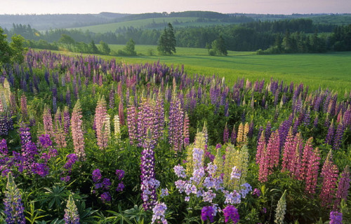
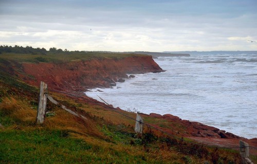
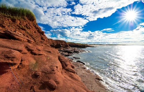
The general landscape of the impressive main island remains primarily pastoral. It’s also quite famous for the unique combination of thickly wooded regions, gently rolling hills, beaches of reddish-white sand, numerous coves, and the ever-present red soil.
Also, present along the shoreline are saltwater marshes and red sandstone cliffs. The northern shore of Prince Edward Island holds numerous dune fields. In Basin Head cape, the properties of the white silica sand actually generate a singing sound when walked on.
CCL: https://bit.ly/1ryPA8o
Prince Edward Island Location and Climate
Surprisingly, Prince Edward Island and its associated numerous small islands and islets comprise one of the provinces of Canada, in North America. Despite its location, however, in general, the local climate remains relatively mild for its latitudinal position.
More precisely, though, during the months of July and August, the usual high temperature is 73 F (23 C). Yet it occasionally experiences highs of as much as 86 F (30 C). Conversely, however, during the coldest months of winter, the average highs are 26 F (-3 C).
Prince Edward Island receives an annual rainfall of 33.7 in (855 mm), as well as a yearly snowfall average of roughly 11.2 in (285 cm). Spring storms are plentiful, due to the constant clash between weather fronts from both the Arctic and the Atlantic weather patterns.
Spotted Lake
CCL: https://bit.ly/3xliBv3
Spotted Lake Facts
- The third entry into this compilation of 4 Geological Wonders of Canada is the remarkable and mysterious Spotted Lake.
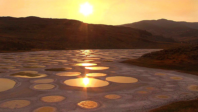
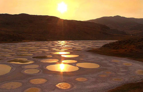
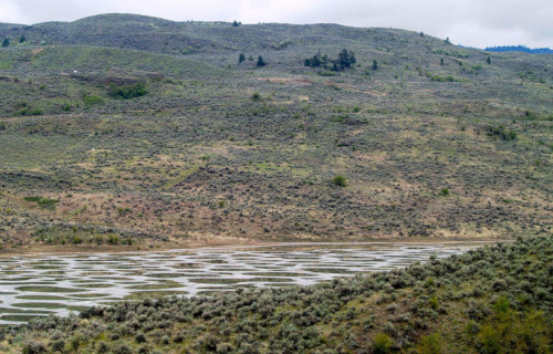
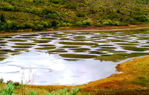
- The most noteworthy thing about the site lies in the form of spots that form on its surface. In fact, these highly distinctive formations appear on a very regular basis. The features appear each summer as the water within the lake slowly evaporates.
- But, that’s not its only claim to fame. This astonishing geological site also played a surprising role in the history of the immediate region. In point of fact, the indigenous First Nations peoples of the region have considered its waters sacred for centuries.
- Further, the site known as Spotted Lake also played a virtually unknown yet vital role in modern history. During World War 1, its minerals were used in the making of munitions for use by the Allies. The private owners of the land later sold it.
- Thankfully, it was to the Okanagan Syilx peoples, and today it forms a protected area. A barrier has also been erected around the site, restricting public access. The location remains both a sacred site and a source of traditional medicine for the First Nations.
CCL: https://bit.ly/2W4pTDG
Spotted Lake Physical Description
Perhaps most notably of all, the mesmerizing uniqueness of Spotted Lake does not rely on sheer size. That’s due to the fact that it actually only represents a very small lake. In point of fact, the unique site only has a maximum length of about 0.43 mi (0.7 km).
The amazing body of water also only possesses a maximum measured width of roughly 0.16 mi (0.25 km). It additionally only has a total shore length equaling about 1.1 mi (1.7 km). Plus, the small but astounding lake itself also has another layer of variability.
That holds true due to the fact that the altitude of the surface of the distinctive lake routinely varies. This occurs because of its constant evaporation with the seasons. Yet, on average, Spotted Lake sits at an altitude of 1,880 ft (573 m).
The distinctive circles themselves also vary in size, depth, and number each year. Yet, though their numbers vary, they average exactly 365 each year. While this appears to be a completely random occurrence, it nevertheless serves to add to the unique aura of the location.
CCL: https://bit.ly/2W4pTDG
Spotted Lake Location and Distinctiveness
The remarkable Spotted Lake isn’t the only alkaline lake in the world. But it’s one of the most distinctive. This marvel of nature also formed in a remote area of the world. It formed in the area of the Similkameen Valley, in British Columbia, Canada, in North America.
The site primarily contains great quantities of several minerals. These include calcium, magnesium sulfate, and sodium. This wonder of Nature also contains smaller quantities of other minerals, and even trace amounts of titanium and silver suspended in its water.
When the water evaporates, the sincerely remarkable features of the amazing Spotted Lake appear. That’s due to the fact that these remain behind as deposits sitting on the newly dry lake bed. Since each spot forms independently, they also appear in different colors.
The randomness of these natural patterns of color occurs as a direct result of varying mineral composition. Due to that composition, though, the local Okanagan Syilx peoples, of the First Nations, continue to use the waters of the lake for medicinal purposes.
Finally, the lake continues to serve as a sacred site to these Peoples. Due to this, numerous cairns surround the lake, containing graves, some of them quite ancient. It’s primarily for this reason that the site remains fenced off from tourists, yet it can be viewed from nearby.
Carcross Desert
CCL: https://bit.ly/3bwozyh
Carcross Desert Facts
- The final entry into this article about 4 Geological Wonders of Canada, the Carcross Desert, may be the most surprising.
- The highly unusual and unexpected location stands out from other similar locations around the world. That’s partly due to its uniqueness. Just like the Maine Desert, its status as an actual desert also remains a source of ongoing debate among scientists.
- Assuming its status as confirmed, this remarkable geological feature further remains one of the northernmost deserts on earth. In point of fact, one of the most astounding things about this surprising site remains its location.
- That certainly isn’t the only thing that makes this impressive site so fascinating to those visit it, however. Quite interestingly, the story of the conservation efforts for the fabulous Carcross Desert unfolds significantly different from most.
- For one thing, there remains most unusual story behind its formation. The beginning of this story took place in the year 1992. To be more precise, at that time, the local government attempted to enact a conservation program for the region.
- Astonishingly, the local populace actually rejected the idea. This represented exactly the opposite of what usually happens in such situations. But, the cause was an ulterior motive. The location remains popular with the local inhabitants.
CCL: https://bit.ly/2xTpie3
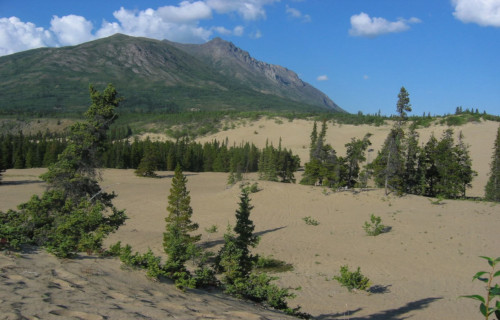
Carcross Desert Physical Description
The small but gorgeous Carcross Desert elegantly proves the point that beauty does not depend upon sheer physical size. That statement holds true due to the simple fact that this marvel of Nature has a size that’s dwarfed by the better known deserts of the world.
In fact, this region of the world boasts an area equaling only roughly 6.23 sq mi (16.14 sq km). But, its distinctiveness does not end there. That’s because the entirety of the region of the Carcross Desert remains arid, despite the climate of the surrounding region.
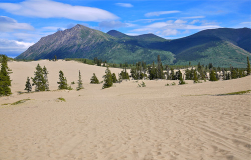
This situation occurs in relation with local weather patterns. That’s due to the rain shadow effect of the nearby Yukon mountains. Furthermore, the area is also prone to strong winds which continually supply the region with new sand from the shores of Lake Bennet.
CCL: https://bit.ly/2VuUrxo
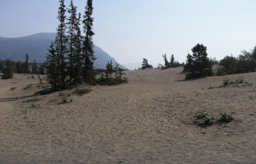
Carcross Desert Location, Ecology, and Recreation
Despite the name, the amazing Carcross Desert does not technically measure as dry enough to be classified as a desert. It nonetheless remains significantly drier than the surrounding area, though. In point of fact, this extends to the entire country.
That holds true due to the fact that the site receives less than 2 in (50 mm) of rain per year. The rest of the country in which it formed, Canada, has a much damper climate. Despite these highly arid conditions, however, a few hardy plants have adapted to the climate.
Most notable among these is the rare Baikal Sedge. The plant’s only known to exist in four other locations in North America. Another species of flora that flourishes here, despite being extremely rare in surrounding regions, is the lovely but delicate Yukon Lupine.
Geological evidence also shows that the area now forming the Carcross Desert holds a somewhat surprising history. To the great amazement of many, the region once comprised a lake bed. This, however, occurred long ago, back in the Pleistocene Epoch.
To be more precise, as well as technically, the area actually qualifies as a close grouping of sand dunes. These also appear closely adjacent to the nearby Lake Bennet. Also, the bountiful sand deposited during the last period of glacial activity.
The extremely unusual location further quickly earned it a distinct status. That’s due to its popularity for various recreational activities. As a result, numerous local residents, and increasingly tourists, as well, utilize the dunes for several activities.
These include numerous types of popular functions. Among these is such uses as hiking, all-terrain vehicular activities, and sand boarding. Finally, the nature of the remarkable site also appears to be rapidly making it a popular site for skydiving.
4 Geological Wonders of Canada
CCL: https://bit.ly/3xliBv3
We truly hope that you have greatly enjoyed this article about 4 Geological Wonders of Canada. This region of the world, despite its reputation for cold and snow, boast many natural marvels. Obviously, these represent only a few of the gifts Nature provided us in this area.
However, many of them now need our help. The effects of such things as climate change and the actions of man threaten some of them. It remains up to each of us to do all that we can to protect and preserves these wonders for our posterity to enjoy as we do.
Check out our other articles on 6 Breathtaking Raptors, 8 Incredible Asian Mammals, Earth’s Many Magnificent Bees, 5 Astounding Sea Snails