


CCL: https://bit.ly/3xaDNnk
It’s our heartfelt hope that each of you, our readers, will thoroughly enjoy and appreciate this article we present about these 4 Remarkable South American Rivers. It was certainly our pleasure to gather the information for you. May it serve to provide you with both education and increased awareness.
Certainly, these few formations listed herein represent only a miniscule portion of the similar marvels found throughout this incredible region. It’s our belief, though, that each of them serve as excellent representations of the features found here. Check out some of our other articles, as well.
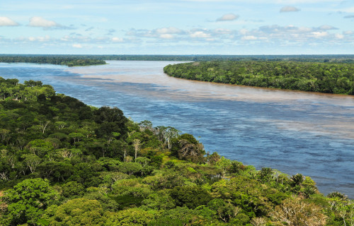
Amazon River
CCL: https://tinyurl.com/462rnnjn
Amazon River Facts
- Starting off this article about these 4 Remarkable South American Rivers we present you with the mightiest of the mighty, the Amazon River.
- This utterly breathtaking creation of natural geological processes remains best known by the english language name that we’ve used here. Yet, other tongues obviously also hold their own version of this. Some of these other titles include Río Amazonas and Amasone.
- This true marvel of the natural world stands out from others in several ways. In terms of discharge volume, it ranks as the largest river in the entire world. The flow also shares the contested title of longest river system on earth with the awesome Nile River, located in Africa.
- The timeline for when humans first arrived in its general region is still a subject of somewhat heated debate among researchers and archaeologists. However, evidence strongly suggests that humans have been present in the immediate area for at least 11,000 to 13,000 years.
- Indigenous Peoples therefore clearly knew of its existence long before European explorers ever discovered it. The annals of history credit that earliest sighting to the Spanish explorer Francisco de Orellana. He encountered it in 1541, while seeking lengendary El Dorado.
- Unfortunately, the stupendous Amazon River also faces numerous challenges. These endanger both its ecosystem and the indigenous communities still highly dependent upon its many resources. Sdaly, ongoing climactic changes continue to alter the surrounding environment.
- Thankfully, portions of its length, at least, do now enjoy a certain degree of legal protection. That’s because four sizeable protected areas currently exist. Two surrounding National Parks currently appear in Brazil, along with one each in the nations of Peru and Colombia.
CCL: https://bit.ly/3KoKlFs
Amazon River Physical Description
The stunningly beautiful Amazon River haunts the dreams and memories of those individuals fortunate enough to view this natural wonder. Yet, the marvel has so much to offer, different visitors always find themselves impressed with varying attributes of this creation of natural processes.
Chief among these natural qualities however, has to be its sheer size. It possesses a length measuring a staggering total of approximately 4,086 mi (6,575 km). Obviously, its width varies countless times along that great length, but at its widest, this reaches an astounding 6.8 mi (11 km).
The depth of this incredible waterway also varies significantly along its incredibly lengthy course. That’s influenced by factors such as rainfall, geography, and human activities. In some areas, the river can be relatively shallow, while in others, it sometimes reaches significant depths.
During the rainy season, the water level understandably rises, in fact, often appreciably. At these times, its waters often plunge as much as 100 ft (30 m) down, or more in the channels. In the dry season, though, this occasionally drops in certain locations to as shallow as an amazing 3 ft (0.9 m).
Given its sheer size, the Amazon River understandably boasts numerous mind-boggling statistics. Among those remains its astounding volume of flow. During the wet season, that’s estimated to be over 7 million cubic feet per second (cfs) or around 200,000 cubic meters per second (m³/s).
Nature further blessed this truly magnificent river with yet one more aspect to challenge anyone’s imagination. That’s the point at which the journey of the enormous flow comes to an end. The mouth of the river formed with an astonishing width of approximately 205 mi (330 km)!
CCL: https://bit.ly/3rhECdc
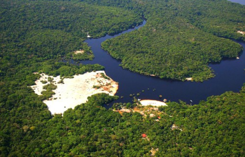
Amazon River Location, Formation, and Ecology
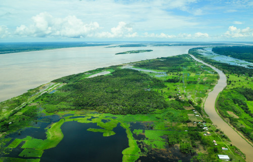
The mesmerizing Amazon River formed in a portion of the globe that practically embodies the concept of natural beauty and wonder. The exact location of this feature therefore likely won’t surprise those few of you who don’t yet know it. It lies in a region of South America.
There, it resides in the general northern part of the landmass. Its course also takes it primarily from east to west, through several different countries. The majority of its extent runs through the territory of Brazil. Other sections, however, also extend through Colombia, Peru, and still others.
It’s virtually imposible to date the age of this body of water with any degree of accuracy. That’s due to the fact that it’s actually had different incarnations. Doubtless, many rivers in the region have existed over countless millions of years, all taking different shapes and paths in each case.
The formation of the Amazon River began with tectonic activity. The continent has undergone significant geological changes over millions of years due to slow yet inexorable plate tectonics. The awesome Amazon Basin, where the river is located, was shaped by this very same movement.
The uplift of the Andes began around 65 million years ago as a result of the collision between the South American Plate and the Nazca Plate. This monumental uplift created a topographical gradient, with the Andes acting as a barrier to moist air coming up from the Atlantic Ocean.
The Basin itself, situated to the east of the Andes, also receives abundant amounts of rainfall during the year. This, combined with the steep slopes of the peaks, leads to the erosion of rocks and the formation of numerous rivers and streams that eventually coalesce into the mighty flow.
Over geological time scales, the course of this masterpiece of Nature has likely further changed multiple times due to the still ongoing powerful tectonic movements, erosion, and sediment deposition. These changes shaped the landscape of the surrounding region in many ways.
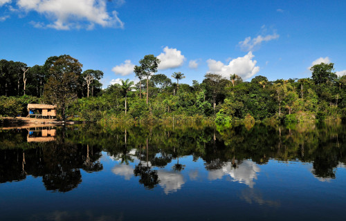
The Amazon River supports and nourishes the surrounding Amazon Basin. That itself serves as home to an estimated 10% of the known species on earth! This includes countless species of mammals, birds, reptiles, amphibians, and insects, as well as a vast array of plant life.
The mighty flow itself supports a rich aquatic ecosystem. It’s home to thousands of species of fish, including iconic species like piranhas, electric eels, and various types of catfish. The river also supports populations of river dolphins, including the Amazon river dolphin, or boto.
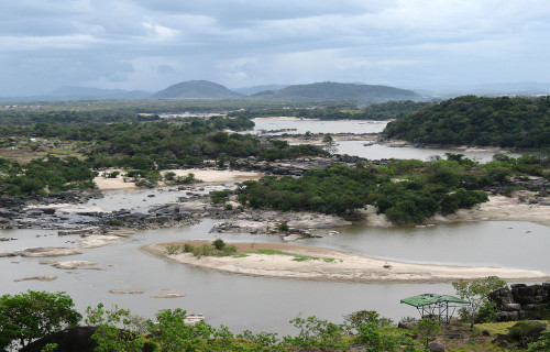
Orinoco River
CCL: https://bit.ly/45oQLPE
Orinoco River Facts
- Next up in this compilation of 4 Remarkable South American Rivers we give you the impressive wonder known as the Orinoco River.
- The deceptively simple term serves as the typical name used for this meandering masterpiece of natural geological formation. It’s also the english language derivative of the Spanish term for the wonder. That term, though, is the very similar name of Río Orinoco.
- Even that moniker, however, derives from an even earlier, far more ancient title for the fascinating body of water. That’s because the local Indigenous Peoples, the Warao, long knew of and utilized the river. In their native language, its title literally meant a place to paddle.
- The first known sighting of the amazing watercourse by outsiders, though, occurred on August 1, 1498. At that time, the well known European explorer, Christopher Columbus spotted its mouth. Fortuitously for Europeans, that event took place during his third voyage of discovery.
- The remarkable Orinoco River stands out for a variety of reasons. It remains one of the longest rivers on the continent it formed on. In terms of total discharge volume, it additionally ranks as the fourth largest on the planet. The formation also serves as a main transportation system.
- The majestic flow of water also held a certain air of mystery well into modern times. That’s due to the incredible fact that its source actually remained unknown to science until 1951. At that time, a joint French-Venezuelan expedition discovered and explored the location of its origins.
CCL: https://bit.ly/3q5gn3W
Orinoco River Physical Description
The outstanding Orinoco River immediately intrigues those individuals fortunate enough to view this true marvel of Nature. The natural feature does so for its sheer beauty, of course. Yet, the fabulous formation also garners much appreciation due to its many other fascinating attributes.
Its course itself forms a comparatively wide, arcing ellipsoid shape. This also surrounds the large structure known as the Guiana Shield, a tectonic plate formation. It’s also roughly divided into four sections of uneven lengths. That’s due to both the nature of the landscape and convention.
The first of these separate sections understandably holds the name of the Upper Orinico. It’s the second shortest part, at 178 mi (286 km) in length. Next comes the Middle Orinoco, at 500 mi (805 km) long. Third is the Lower Orinoco, at 596 mi (959 km), then Delta Amacuro, at 120 mi (200 km).
Combined, these individual components of the Orinoco River provide it with a prodigious length. Due to their union, the captivating river stretches for an impressive 1,400 mi (2,250 km). Much of its full course, however, wends its way back and forth across the surrounding landscape of the region.
Yet it’s not very deep compared to other rivers. It only has a maximum measured depth equaling around 330 ft (100 m). Despite this, though, it manages its impressive discharge rate. This averages 1,333,000 cubic ft (37,740 cubic ms) per second! Its maximum rate exceeds this by almost 50%.
CCL: https://bit.ly/3ML3s06
Orinoco River Location, Formation, and Ecology
The mind-boggling beauty known as the Orinoco River formed in a part of the world already renowned for its extraordinary abundance of natural beauty. That general location won’t surprise many people, however. That’s because this marvel sits on the continent of South America.
Its location places the wonder of Nature in the immediate northerly portion of that continent. There, the majority of its great length lies within the boundaries of the country of Venezuela. The remainder of its expanse falls inside the national confines of the sovereign state of Colombia.
As we now know, this astounding creation of natural forces begins at the southern end of the Parima Mountains, in Venezuela. Its headwaters originate near Mount Delgado Chalbaud. From its humble beginnings, its waters flow west-northwest, departing the mountains from which it sprang.
As it meanders, the wondrous river increases vastly in volume due to the influx of waters from multiple tributaries from the surrounding mountains. Many of these sources themselves form from the prodigious rainfall prevalent to the region. A few of them, though, arise from natural springs.
The beautiful Orinoco River plays a pivotal role in the ecology of the region in which it lies. Its waters serve as home to an abundance of wildlife. Mammals such as river dolphins and the giant otter thrive in its depths. One of the rarest reptiles on earth, the Orinoco crocodile, does too.
Understandably, a staggering number of fish species also continue to flourish within its confines. Over 1,000 known species do so, in fact. Roughly 15% of these appear nowhere else on the planet. That even includes such unfairly notorious animals as the Pacu, a cousin of the piranha.
Cano Cristales
CCL: https://bit.ly/3xaDNnk
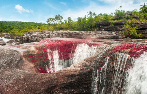
Cano Cristales Facts
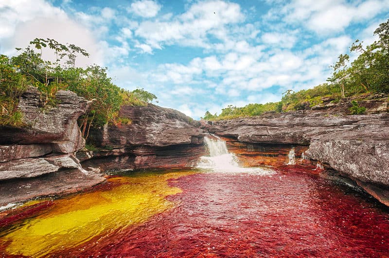
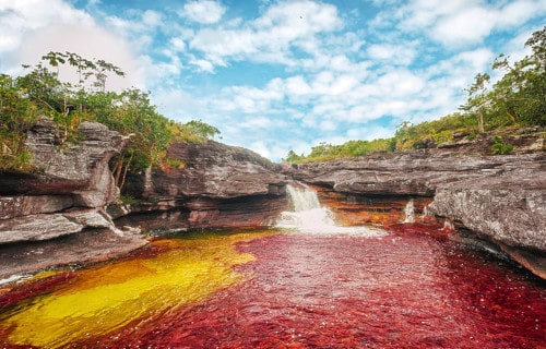
- Our next choice for inclusion in this listing of these 4 Remarkable South American Rivers is the truly enchanting marvel named Cano Cristales.
- This astounding marvel of Nature forms a watery kaleidoscope bearing the name it does, meaning Crystal Channel in English, for good reason. Its beauty easily entrances all those individuals fortunate enough to encounter this marvel of natural processes in person.
- This remarkable geological feature also goes by several other names, especially among the local residents. These alternate names include such vividly descriptive terms as the Liquid Rainbow and the River of Five Colors, just to list a few of the many distinctive titles used.
- This astonishing semblance occurs completely naturally, due to a highly unique and utterly breathtaking combination of geological and botanical factors. As a result of its appearance, many individuals consider this stunning flow to be the most beautiful river on earth.
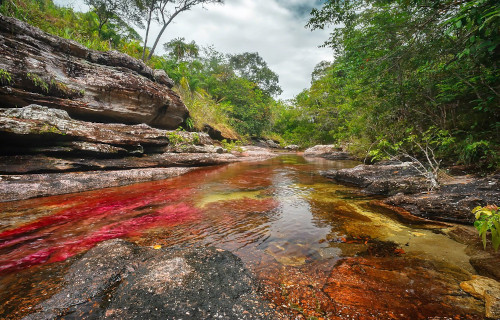
- This opinion largely exists due to the fact that the river presents a mind-boggling appearance. That’s because it presents a total of five separate colors. For about half of the year, however, only four of the gorgeous colors appear visible. That alone, though, makes it highly remarkable.
- During the other half of the year, though, the fifth color quickly manifests as well, serving to aid in dazzling the viewer. This, therefore, completes the startling transformation of the river. The brilliant colors presented in its waters include those of green, yellow, blue, black, and red.
- The gorgeous Cano Cristales now enjoys a certain amount of protection from the depredations of man. It lies within the Serranía de la Macarena National Natural Park. This biodiversity hotspot’s protected due to its unique ecosystems, endemic species, and geological formations.
Cano Cristales Physical Description
The breathtaking Cano Cristales never fails to immediately capture the attention and imagination of anyone fortunate enough to visit the feature. Unlike some similar flows around the world, however, this marvel of natural formation possesses multiple impressive physical characteristics.
Although it wends its way casually through the surrounding terrain, it stretches for a length that, while it may not compare to rivers like the Amazon River, it’s nonetheless respectable. Overall, this captivating body of water drifts its way for a distance totaling approximately 62 mi (100 km).
Although this water-based wonder certainly boasts hypnotic qualities of other sorts, width does not rank among them. That’s because this remarkable river never attains a span greater than 65 ft (20 m) at any point along its course. In fact, for most of its length it measures notably less than this.
Just as notably, it also maintains a comparatively shallow depth at all times. Even at its most extreme, the water never measures more than 65 ft (20 m) from the floor to the surface. For most of its extent, in fact, the magnificent flow remains significantly less deep than even this minor state.
Without doubt, however, it’s the mind-numbing beauty of Cano Cristales that garners the most attention from visitors and readers alike. These brilliant hues primarily occur due to the presence of a specific aquatic plant. This plant thrives during the wet season, typically from June to November.
Generally, the red shades remain the most predominant of the multiple colors contained within its confines. The relative strength and sharpness of the other tints vary widely, largely depending upon numerous environmental factors, such as water levels and the amount of sunlight received.
CCL: https://bit.ly/3xbS2s6
Cano Cristales Location, Formation, and Ecology
The almost incomprehensible marvel that’s Cano Cristales formed in a general region of the world already well known for its abundance of natural marvels. The exact location of that unique setting therefore probably won’t surprise many of our readers. Nature created it as part of South America.
Within that greater, and also quite extensive, landmass, though, its location places it within a comparatively remote section of the continent. That area consists of the section that now constitutes the country of Colombia. This unique river additionally lies within in the Meat province.
The river formed through a majestic combination of ancient geological processes and unique ecological conditions that came together over a span of hundreds of millions of years. Its origins remain tied to one of the oldest geological formations on Earth and an exceptional environment.
It flows over quartzite rock that forms part of the Guiana Shield, one of the oldest rock formations on the planet, being approximately 1.2 billion years old. Over great time, natural forces like water erosion and weathering inexorably carved out the river’s channels, waterfalls, and circular pools.
Nature still wasn’t finished, though. Eventually, what now comprises the Serranía de la Macarena mountain range uplifted through tectonic activity. This small, isolated chain separated the region from the Andes, and contributed to its unique mix of Andean, Amazonian, and Orinoco features.
This river one of the most unique and biodiverse ecosystems in its area, shaped by its geological age, location at the convergence of three major ecosystems, and strict environmental protections. Its ecology remains defined by a delicate balance of climate, hydrology, plant life, and endemic species.
The Macarenia clavigera, the mmost iconic plant of Cano Cristales, is responsible for the river’s red, pink, and green hues during the wet season. It grows on submerged rocks in clean, shallow, fast-flowing water. Algae and mosses also coexist with it, although none exhibit the same striking colors.
Due to the low nutrient content, high water clarity, and rocky substrate, it supports only a limited number of fish species. Those present are small and adapted to nutrient-poor, fast-moving water. Crustaceans, aquatic insects, and snails remain more common, forming the base of the food web.
Its waters also support a vast and diverse array of terrestrial wildlife in its area. Some of the mammals include jaguars, pumas, tapirs, and monkeys. Countless insects, poison dart frogs, iguanas, and various snakes also depend on it. Over 400 avian species rely on its waters as well.
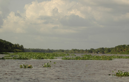
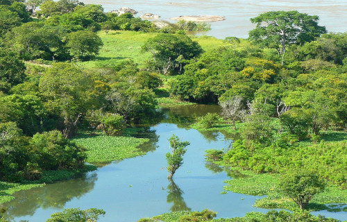
Rio Negro River
CCL: https://bit.ly/2xO159d
Rio Negro River Facts
- Finishing up this compendium of 4 Remarkable South American Rivers we give you the distinctive feature known as the Rio Negro River.
- The descriptive term perfectly fits as the generally accepted name for this truly incredible and distinctive work of Nature. That’s due to the intriguing fact that, within the Spanish language, the term applied to the remarkable feature quite literally means Black River.
- The name for the captivating flow fits so well for a very specific reason, however. That statement holds true because of the fact that this marvelous work of Nature actually represents the largest known example of what’s known as a blackwater river in the entire world.
- As if this wasn’t enough to impress one, though, this awesome geographical feature fully merits respect for yet another very respectable reason. Incredibly, in terms of its average rate of discharge, this body of water also represents one of the ten largest rivers on the planet.
- In fact, its truly immense span sometimes creates certain difficulties for humans. Remarkably, its vast size serves as the source of occasional confusion. That holds true due to the fact that, in some of the regions it passes through, the marvel goes by the name of the Guainía River.
- As if everything else of note was not enough to distinguish it, the astonishing Rio Negro River also has an extraordinarily rich and fascinating history behind it. This remarkable situation further remains equally true in terms of both ancient and comparatively modern times.
- For the moment, at least, it currently remains unknown to historians just how long the various local Indigenous Peoples knew of the existence of this natural resource. However, its modern discovery occurred early in what’s known as the modern era of exploration.
- In point of fact, the highly renowned Spanish explorer, Francisco de Orellana remains the first known European to record an observation of this prodigious creation of geological processes. This lucky discovery additionally occurred early in the exploration phase, in the year 1541.
CCL: https://bit.ly/2T5rwPd
Rio Negro River Physical Description
Astoundingly, despite its own extreme size, the amazing Rio Negro River itself forms the tributary of another, even more impressive river. It nevertheless does have a beauty, splendor, and a uniqueness all its own. The wonder’s very often arbitrarily divided into three very distinct sections, too.
At first, the upper course of the marvelous river lies in the highlands of the nation of Colombia. From there, however, it casually flows roughly east-northeast, and passes through the Puinawai National Reserve. This part of the river also flows through many small indigenous settlements.
Meanwhile, the middle course of the stunning body flows through yet another neighboring country. Along the way, it’s joined by numerous tributaries, significantly swelling its flow. This section consequently remains filled with numerous extremely powerful rapids, as well as small islands.
At one specific point along this incredible stretch, the Rio Negro River actually constitutes the geographical border of three countries. After that, the lower course continues primarily flowing eastward. It also contains even more small islands, and narrows and broadens quite frequently.
Astonishingly, though, during the local wet season, Nature actually takes this natural marvel to even greater heights. That’s due to the fact that, at this time, it also forms countless small lagoons, complex channels, and even more, though temporary, islands throughout this section.
CCL: https://bit.ly/3coAAGw
Rio Negro River Location, Nature, and Fauna
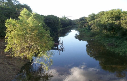
The breathtaking and highly fascinating feature known as the Rio Negro River formed in an already astonishing part of the surface of the world. That holds true because it originates in a portion of the world very well known for its great natural beauty, that of the continent of South America.
More precisely, though, this truly magnificent work of Nature and geology runs through three separate countries. Those are the countries of Brazil, Colombia, and Venezuela. The astounding creation of inexorable forces also boasts an overall length of an incredible 1,400 mi (2,250 km).
But, its most distinctive feature remains the one for which it’s so aptly named. Many portions of the waters of the remarkable river display a dark brown, almost black color. That’s due to the continual presence of large volumes of humic acid, from vast amounts of decomposing vegetation.
Since it forms a tributary of the mighty Amazon River, another factor of the intriguing nature of the Rio Negro River stands out. Not surprisingly, its waters play host to a remarkabaly broad variety of life. Among these are more than 700 species of fish, including the potentially dangerous Pacu.
Researchers further believe several hundred more species may still remain unidentified by science. Incredibly, at least 100 of these species do not seem to appear in any other area of the world. Countless varieties of turtles also make their home within the highly unique depths of the river.
CCL: https://bit.ly/3rhECdc
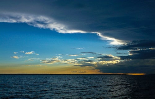
4 Remarkable South American Rivers
We truly hope that each of you greatly enjoyed reading, and hopefully learning something from, this article we’ve written about these 4 Remarkable South American Rivers. It’s also our fervent hope that doing so has left you with either a new or renewed appreciation for such wonders of Nature.
Unfortunately, many other such features in various places around the world now find themselves facing severe threats to their continued existence in an undamaged state. Many of those dangers, in fact, stem from the actions of mankind. We must do all we can to protect and preserve them all.
Check out our other articles on 7 Captivating United States Lakes, Native North American Mammals, 6 Incredible Asian Islands, Earth’s Geothermal Marvels, 5 Extremely Beautiful Epiphytes