


We sincerely hope that you enjoy this article about 5 Geological Marvels of Arizona. This part of the world just seems to teem with geological wonders, and this region is no exception to that. These wonders come in all shapes, sizes, natures, and characteristics.
No matter what type of formations you like, you will find something here to appreciate and enjoy. Many of these have been in the works for millions of years. Some of them, on the other hand, are of comparatively recent creation. All of them though, are amazing.
Havasu Falls
Havasu Falls Facts
- Leading off this article about 5 Geological Marvels of Arizona comes the stunning site known as Havasu Falls.
- Without doubt, the mesmerizing location easily ranks as one of the most beautiful waterfalls in the world. It also goes by the name of Havasupai Falls. By either name, the site also remains one of the most difficult falls in the world to access.
- That lamentable fact, however, serves to provide it with at least a measure of protection, to preserve it in its natural state. In point of fact, two very specific factors currently serve to limit access to this marvel of Nature, aiding its preservation.
- The site sits on tribal land belonging to a small group of Indigenous Peoples. Understandably, the tribe strictly regulates the number of visitors to the location. Access to the site remains limited to those acquiring a permit from local authorities.
- In addition to this requirement of man, the very nature of the surrounding terrain also serves to make it difficult to access. Although this makes it more difficult for those who appreciate Nature to view it, this fact can certainly be respected.
- The local topography makes it nearly impossible to gain access to the site from the ground without the knowledge of the indigenous inhabitants of the region. Its sheer natural beauty gives this awesome wonder of Nature a truly powerful allure.
- This trait has garnered breathtaking Havasu Falls international attention several times, in some ways. With the permission and cooperation of local authorities, its beauty has been featured in both a Hollywood movie, and a music video.
Havasu Falls Physical Description
The fame of the truly stunning Havasu Falls derives purely from its natural beauty. This notoriety, although certainly well-deserved, has no basis in its physical size. This holds true due to the fact that the waterfall represents no more than an average sized cascade.
This status pertains to both its height and width. For one thing in particular, the waterfall itself consists of a single stage, much like the vast majority of similar features scattered throughout the world. In its case, the water plunges a total of about 100 ft (30 m).
It also does so over a series of several vertical cliffs. These cliffs have a composition primarily consisting of dark reddish sandstone. Without a doubt, the most visually striking feature of Havasu Falls remains the breathtaking color of the water itself.
This occurs due entirely to the fact that the underlying rock strata contains high concentrations of calcium carbonate. This natural compound slowly but steadily distills into the flow of water, continually providing that water with an astounding aquamarine color.
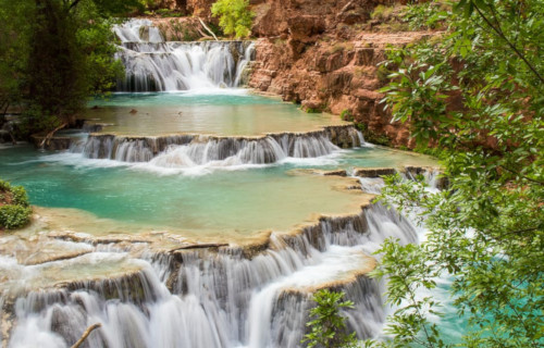
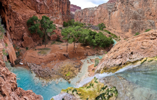
Havasu Falls Location, Formation, and History
Surprisingly, Havasu Falls sits within another larger, and far better known, natural marvel. That other wonder of Nature is none other than the Grand Canyon itself. The waterfall, therefore, formed in what now constitutes the state of Arizona, in the United States.
Along with the canyon, this waterfall forms another of the great natural wonders of North America. The stunning cascade formed on what became tribal land of the Native American tribe, the Havasupai. The tribe has lived at the site for more than 800 years.
This astonishingly beautiful cascade also formed through a unique, but highly effective, combination of two processes. These factors in its creation consisted of both slow erosion over time, and rapid erosion due to the occurrence of flash floods in the area.
The high levels of calcium carbonate in the water also leaves deposits as it flows along. Over time, these minerals built up in several places, forming small but magnificent travertine steps. The frequent flash floods in the region often changes these, however.
Sometimes one or more of these beautiful but very delicate features becomes reduced due to the force of the flood, or even demolished, to be reformed later. Because of the occurrence of the same flash floods, the nature of the waterfall itself often changes.
Prior to one powerful flood, Havasu Falls flowed in one broad sheet. Since then, the form of the flow has changed on several occasions. Currently, it flows in a single sheet of water, whose temperature remains a near-constant 70 degrees Fahrenheit (20 Celsius).
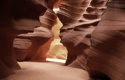
Antelope Canyon

Antelope Canyon Facts
- Next up among these 5 Geological Marvels of Arizona comes the magnificent site given the name of Antelope Canyon.
- The truly amazinglocation represents yet another visually stunning geological formation in its part of the world. It also, quite understandably, now constitutes an extremely popular tourist destination in its part of the world.
- It further, and again, understandably, represents an extremely popular subject for photographers, both amateur and professional alike. Its unique and impressive physical characteristics make it unlike virtually any other spot of Earth.
- The site does, however, lie in a region consisting of extremely rugged and sometimes hazardous, terrain. This same region also happens to lie on what now constitutes lands belonging to Native Americans of the Navajo Nation.
- Since it also formed on what now represents native Navajo land, Antelope canyon is accessible only by guided tours. This fact, however, serves to provide the site with a certain measure of protection against the potential ravages of humans.
- This requirement further serves to ensure the safety of visitors to the natural marvel. During the rainy season, sporadic flash floods occur in the area. These have a tendency to arrive without warning, converting the passageways into a severe danger zone.
Antelope Canyon Physical Description
The mind-boggling Antelope Canyon truly dazzles the eye and befuddles the min of those who experience it firsthand. The formation does not do so, however, due to it sheer physical size, but because of the incredible nature of its physical structure.
Quite surprisingly, perhaps, the site manages to compress all this stunning beauty and distinctiveness into a relatively small structure. More precisely, this wonder of geological and meteorological forces only has a total length measuring roughly 1,9995 ft (607 m).
This becomes further impressive when one realizes that the incredible Antelope Canyon actually comprises two distinct sections. That very statistic helps to immediately distinguish it from the vast majority of other canyons situated around the world.
The first section bears the original Navajo name of Tsé bighánílíní, which roughly translates to the place water runs through rocks. The second section meanwhile, holds the original name of Hazdistazí, which roughly means Spiral Rock Arches, in English.
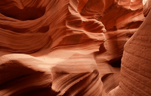
Antelope Canyon Location, Formation, and Hazards
The awesome splendor of Antelope Canyon formed in a part of the world well respected for its extreme geological beauty. That’s due to the fact that this site was molded by forces in what now constitutes the state of Arizona, in the United States, in North America.
Somewhat surprisingly, this particular canyon does not owe its formation to any volcanic or earthquake activity. This fact alone serves to even further distinguish it from the great majority of remarkable geological formations in this area of the continent.
To the amazement of some, long-term erosion of the native Navajo sandstone in the region formed the canyon into two distinct sections. This occurred over the course of thousands of years, primarily due to the flash floods the region remains prone to.
Also, a secondary erosive effect was that of desert winds funneling through the slot canyon throughout the years, with powerful force. Such occasionally forceful winds continue to affect the site sporadically, along with further flash flooding.
These continue to pose a danger in Antelope Canyon, even though safety measures exist. The U.S. Weather Service has a warning siren in place at the point where tours enter the canyons. But the flow rate of such floods through the two sections is unpredictable.
On August 12, 1997, prior to the installation of the siren, 11 tourists lost their lives in a flash flood in the Lower Canyon. No rain was falling at the site, but a locally heavy thunderstorm upstream dumped enormous quantities of water into the canyon in a matter of minutes.
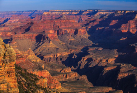
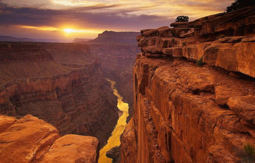
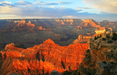
Grand Canyon
Grand Canyon Facts
- Placing third in this listing of 5 Geological Marvels of Arizona, the spellbinding Grand Canyon does so only due to random selection.
- This is the absolutely breathtaking marvel of Nature understandably known by the right name. It remains perhaps the best known feature of its kind in the world. However, despite its well-deserved reputation, it’s not the longest of its kind.
- Nonetheless, its grandeur and sheer size leave those who experience it firsthand shaking their heads at the majesty of the site. But the local Native American tribes have other names for it in their native tongues. These have been used for many centuries.
- In the native Navajo language, it’s called Bidááʼ Haʼaztʼiʼ Tsékooh. Among the Yavapai, though, this incredible site goes by the name of Wi:kaʼi:la. Meanwhile, the Hopi people employ the name of Ongtupqa for this true wonder of natural forces.
- Regardless of the name used to refer to it, though, some things remain the same. For one thing, the aptly-named Grand Canyon represents one of the most widely recognized geological feature found anywhere on the planet. And that’s as it should be.
- In addition, this site quite literally provides a window into the past unlike anything found anywhere else. That’s due to the fact that geologists have the ability to study the work of around 2 billion years of geological processes in the rocks.
Grand Canyon Physical Description
The sheer scale of the awesome Grand Canyon can make it difficult to fully appreciate. Simply quoting statistics cannot adequately convey the proper impression of this geological marvel. Nonetheless, we offer them here, as a beginning of appreciation of its magnitude.
Firstly, its sheer length often represents a staggering number to contemplate for the casual learner. That’s due to a lack of proper perspective with which to consider it. This astounding site further measures a grand total of roughly 277 mi (446 km) in length.
Secondly, its other dimensions remain equally mind-numbing. Take its width, for example. While this quite naturally varies constantly along its length, this remains enormous in even the narrowest areas. But, that’s because at its widest it attains a width of 18 mi (29 km).
Thirdly, its depth only adds to the otherworldly air of the incredible Grand Canyon. Though it’s not the deepest such feature in the world, by far, it’s nevertheless remarkably impressive. While the depth naturally varies, it reaches a maximum of 6,093 ft (1,857 m) in places.
Grand Canyon Location, Formation, and Geology
The gorgeous Grand Canyon formed in a distinctive region of the Northern Hemisphere already renowned for its natural beauty. This principle extends to the highly numerous beautiful, though relatively harsh and sometime stark, landscapes so common in that region.
That holds true due to the fact that this astonishing feature of geology formed in a region of what now constitutes the United States, in North America. More precisely, the gigantic canyon runs through an extensive section of the state that bears the name of Arizona.
Plus, it also shares this region with other natural features. These include the aptly-named Grand Canyon National Park, the Kaibab National Forest, and the Grand Canyon-Parashant National Monument. The canyon itself also contains the equally stunning Havasu Falls.
Incredibly, the eye-opening Grand Canyon forms part of the Colorado River Basin. As such, its creation serves as the perfect testament to the power of erosion. Admittedly, however, in its case, this process required a period estimated by geologists at roughly 70 million years.
Its unique nature and sheer size make it a location of unequaled importance to geologists. That’s due to the presence of sections of deposits over many hundreds of millions of years. In fact, one area of deposits, known as the Vishnu Schist, measures 2 billion years old.
The Wave
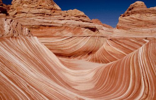
The Wave Facts
- Appearing next in this compendium of 5 Geological Marvels of Arizona is the dazzling site aptly named The Wave.
- The short and simple, but descriptive, term for it serves as the name of a particularly beautiful and remarkable geological formation. It also now represents one of the sites most frequently visited by tourists in its part of the continent.
- It’s also presently managed and maintained by the Bureau of Land Management, a federal organization. Thankfully, this does manage to afford the marvel of Nature with at least a certain amount of protection against the ravages of man.
- This truly breathtaking site also understandably now remains extremely well-known and popular among photographers. This occurs due to the incredible color patterns and the undulating forms that appear within its confines.
- Dedicated hikers also love the region for the extreme difficulty in simply reaching it. Although this also manages to provide it with some protection, it’s not enough. The entire area, due to its nature, remains extremely fragile and easily destroyed
- The immediate region, what now forms the Coyote Buttes Wilderness Area, requires special permits to enter it. The governing body overseeing its management further limits the number of visitors to The Wave to only 20 per day.
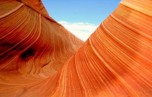
The Wave Physical Description
The breathtaking formation bearing the name of The Wave truly stands out among similar geological features. It does not do so, however, based on the merits of its sheer physical. It therefore proves the old adage about size being wholly irrelevant to importance.
Amazingly, in fact, this unique feature formed comprised of two major troughs. One of these wonders of natural processes, though, remains significantly larger than the other. The larger trough measures roughly 62 ft (19 m) wide, and about 118 ft (36 m) in total length.
The second component of the mind-boggling and unique structure man now calls The Wave, however, has far smaller dimensions to its credit. More precisely, this part of the feature only measures approximately 7 ft (2.1 m) wide and 52 ft (16 m) long.
The startling visual pattern formed due to the accumulation of layers of sand deposited atop existing layers. These later clung to the sandstone. It remains a stunning formation composed primarily of sand dunes that slowly changed to sandstone 190 million years ago.

The Wave Location, Formation, and Nature
The magnificent work of Nature we now call The Wave formed in a portion of the world highly respected for its vast geological beauty. In point of fact, the site formed in an area that now straddles the border between the two beautiful states of Utah and Arizona.
More precisely, this exact area lies in the desert regions of the country of the United States, in North America. The specific region in which it formed has been shaped over millions of years by a wide variety of natural forces, including volcanism and erosion.
The troughs comprising the awesome site called The Wave were originally eroded by rainwater. The basin that fed the rainwater through the area long since shrank below the point of being able to continue the process. Now it continues through wind erosion.
This site can be accessed only by an arduous hike over the extremely rough terrain. That type of terrain remains the norm throughout the entire area. Being a sandstone formation, the ridges and ribbed areas remain so fragile, that they will crumble underfoot.
Grand Falls
Grand Falls Facts
- The fifth and final of our entries into this compilation of 5 Geological Marvels of Arizona is the stunning Grand Falls.
- The fully appropriate term for the site serves as one of the common names generally applied to this visually stunning waterfall. This geological wonder also, however, goes by the equally apt other name of the Chocolate Falls, for some people.
- For the moment, it remains undetermined who among the various explorers to the area first encountered the cascade. The local Native American population, however, had understandably long known of the existence of this marvel of Nature.
- For the latter centuries of its existence, the land the marvelous cascade formed on became shared by members of the Navajo Nation. In point of fact, these proud Indigenous People still have legal control of, and maintain, the immediate region.
- In a pleasantly surprising twist, the very nature of the surrounding environment aids in its protection and preservation. The part of the region in which it sits possesses an extremely rugged terrain, limiting the number of its visitors.
- Further protecting it, access to Grand Falls remains allowed only by a special permit, and with the express knowledge and permission of the Navajo Nation officials. In fact, even experienced hikers are advised against visiting the site without local guides.
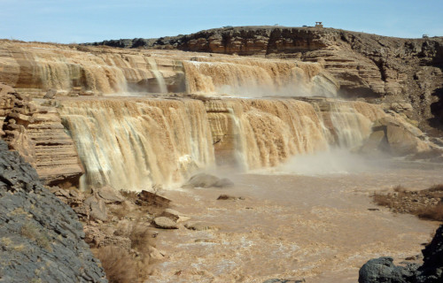
Grand Falls Physical Description
Spotting the truly breathtaking formation known to man as Grand Falls makes several things immediately clear. To the amazement of those who have the good fortune to visit it, this site remains incredible for not just its beauty, but for its sheer size as well.
Certainly, its sheer physical dimensions qualify it as an impressive specimen of waterfall. Although its exact width naturally varies with the amount of water flowing at any one time, this measurement averages a highly respectable 200 ft (61 m).
The overall height of the visually impressive formation, meanwhile, also never fails to impress the visitor or researcher. Given that this characteristic of the beautiful cascade measures approximately 185 ft (56.4 m), that’s not at all surprising, though.
The magnificent Grand Falls also remains renowned for yet another characteristic. That’s the fact that its waters remains almost constantly extremely muddy. This state is so strong, in fact, that it often prompts some to compare the color to chocolate, hence the other name.
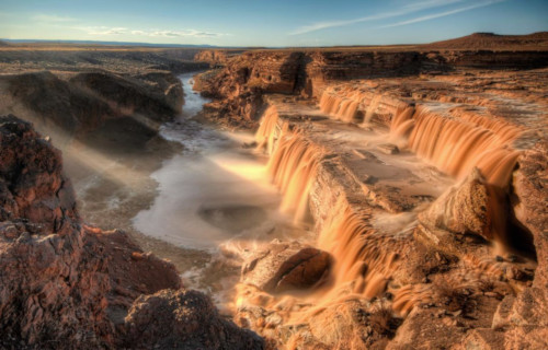
Grand Falls Location, Formation, and Distinctive Characteristics
The visually stunning, and simultaneously fascinating, Grand Falls formed in a region of the globe already well known for its beauty. That’s because this wonder formed in what now constitutes the state of Arizona, in the United States, in North America.
It also formed a very long time ago. Current estimates, based on geological records, indicate that it formed roughly 150,000 years ago. In point of fact, this formation took place in a portion of the region currently given the. literally, colorful name of the Painted Desert.
At that time, the eruption of an ancient volcano formed the nearby Merriam Crater. Lava from the eruption flowed into what’s now named the Colorado River and formed a natural dam. The resulting rerouting of the river eventually created Grand Falls.
During the dry season, the flow rate reduces to a slow trickle and sometimes even ceases entirely. During the winter, snowmelt creates an almost steady flow. Sporadic torrential rains also create an enormous flow for brief periods when they occur in the region.
We truly hope that you have thoroughly enjoyed reading and learning from this article about 5 Geological Marvels of Arizona. This region of the Earth abounds with natural wonder and beauty, and that principle extends to its geology as well as its flora and fauna.
The variety also seems to know bounds, either. As a result, you can find virtually all kinds of landscapes here. But, many of them are fragile, and thus need our protection. It is up to each of us to do all that we can to preserve them for our posterity.
Check out our other articles on 5 Incredible South American Islands, 5 Fabulous European Mammals, Earth’s Many Astounding Beetles, 4 Fabulous Snakes of Asia