


CCL: https://bit.ly/36YrPPU
We hope that you enjoy this article about 5 Incredible South American Islands. Most people probably do not associate South America with islands, but they do exist, as this article attempts to show. Though their landscapes differ, all present magnificent beauty to the world. Some of them, however, remain vulnerable to the depredations of man. We must do all we can to protect and preserve them. In the meantime, enjoy learning about these particular 5 Incredible South American Islands.
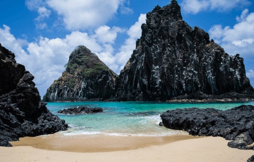
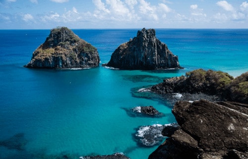
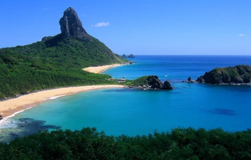
Fernando de Noronha
CCL: https://bit.ly/1p2b8Ke
Fernando de Noronha Facts
- Leading off our listing of 5 Incredible South American Islands is the absolutely mesmerizing location known as Fernando de Noronha.
- First of all, the breathtaking archipelago known collectively as Fernando de Nornoha ranks as one of the most remarkable sites on the planet. Quite unfortunately, however, this remarkable place also holds another regrettable distinction. That’s because it’s also another of those incredible works of Nature that few people outside of its part of the world know about.
- In addition, this stunningly beautiful location also continues to remain sparsely populated. This fact helps to preserve its pristine beauty. In fact, the permanent human population of Fernando de Noronha consists of fewer than 3,100 individuals. The entirety of this number inhabits the main island of the archipelago, which comprises the vast majority of the total area.
- Furthermore, beginning in the year 2001, UNESCO listed the location as a World Heritage Site. This occurred due to the importance of the unique environment of this marvel of Nature. Firstly, the islands of the archipelago serve as home to several avian species. Secondly, these also form a haven for the Critically Endangered Hawksbill Sea Turtle. Finally, the surrounding waters form an important feeding ground for many sea species.
CCL: https://bit.ly/1p2b8Ke
Fernando de Noronha Physical Description
Most notably, all components of the gorgeous Fernando de Noronha archipelago remain quite remarkable. That’s because these actually represent the uppermost portions of an underwater mountain range. Further, the various islands and islets all clearly reflect their volcanic origins.
The archipelago consists of an impressive total of 21 islands and islets, most being quite small. In point of fact, the principal island of the archipelago has a total area measuring roughly 7.1 sq mi (18.4 sq km). This represents roughly 71% of the total area of the group, since the total area of all islands and islets is about 10 sq mi (26 sq km).
However, this area forms only a tiny portion of the full size of the astounding formation. That’s because the base of this large volcanic formation lies roughly 2,480 ft (756 m) beneath the surface of the ocean. In addition, the highest elevation of the archipelago lies at 1,060 ft (323 m).
CCL: https://bit.ly/1ryPA8o
Fernando de Noronha Location, Climate, and Life
The magnificent location named Fernando de Noronha formed as a small archipelago in the Atlantic Ocean. More specifically, the site lies roughly 220 mi (354 km) off the coast of the country of Brazil. The entirety of the archipelago forms a part of this country, located in South America.
Not surprisingly, the climate of each of the islands and islets also has a primarily tropical nature. Furthermore, and quite uncommonly, the temperature actually varies very little, either between day and night, or month to month. Additionally, it only has two seasons, rainy and dry.
Perhaps most notably, the archipelago of Fernando de Noronha serves as home to a highly diverse population of plant and animal species. Furthermore, many of these various species exist nowhere else in the world. In fact, a known total of at least 15 endemic species of plants fit that description.
Included among the species existing here and nowhere else on earth are three species of birds, and two reptilian species. In addition, a fully indigenous rodent species known nowhere else once inhabited the islands. However, this animal became extinct long before humans found the location.
Finally, the various beautiful islands and islets remain famous for yet another specific reason. That’s due to the great beauty, extensive variety, and sheer quantity of marine life appearing in the local waters. This includes such creatures as dolphins, sea turtles, and numerous albatrosses.
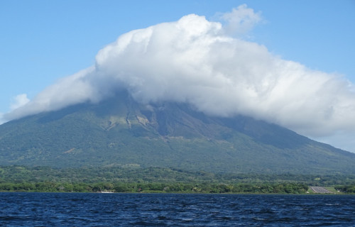
Ometepe Island
CCL: https://bit.ly/3beTob1
Ometepe Island Facts
- Next up among our selections for inclusion in this compendium of 5 Incredible South American Islands is the awesome Ometepe Island.
- Firstly, the name of the island derives directly from the ancient Nahuatl language. The combination consists of the words ome, which means two, and tepetl, which means mountain. Therefore, the unique name of the astonishing location quite literally translates as two mountains.
- Perhaps most notably, the truly remarkable island constitutes one of the most unique islands in the world. This statement holds true due to a combination of several fascinating factors. For one thing, much of the incredible island now qualifies as a UNESCO Biosphere Reserve.
- But that fact represents only the tip of the spear, so to speak. First of all, the island is actually composed of the tops of two volcanoes rising up out of the water. Secondly, it sits within the confines of a large lake, not the ocean. It also forms the largest of several islands within this lake.
- Not only that, but, due to its great size, Ometepe Island also holds a particularly singular title. That’s because the location remains the largest known volcanic island formed within a freshwater lake, anywhere in the world. Thus, the distinctive island truly qualifies as a marvel of Nature.
CCL: https://bit.ly/2GTGOzS
Ometepe Island Physical Description
First of all, the magnificent Ometepe Island has a most unusual shape, in addition to its other remarkable attributes. That’s because the two volcanoes that comprise the island are connected by a very shallow isthmus. This serves to give the island a strongly hourglass-shaped configuration.
The two volcanoes forming the island bear the names of Concepción and Maderas. For the moment, Concepción holds a roughly symmetrical cone shape. The mountain also continues to stir into activity on occasion. This volcano originally rose in the early Holocene Epoch, and, thanks to its continued occasional eruptions, now reaches the impressive height of 5,282 ft (1,610 m).
Meanwhile, the southeast half of the island consists of the other volcano, Maderas. This half of the pair appears to be either extinct or dormant. Volcanologists remain somewhat divided over this. Astoundingly, this volcano has itself holds a small lake in its crater. It also formed during the Holocene Epoch. For the moment, it reaches a height of roughly 4,573 ft (1,394 m).
CCL: https://bit.ly/2GTGOzS
Ometepe Island Location, Ecology, and Wildlife
Most remarkably of all, the stunning Ometepe Island formed in an equally amazing location. The fascinating and quite unique island itself sits in the middle of the beautiful Lake Nicaragua, situated in the Republic of Nicaragua. Furthermore, this amazing island of South America has a total area measuring an impressive 107 sq mi (276 sq km).
Quite unfortunately, the northwest section of the island possesses a rather stark, and exceedingly harsh landscape. However, the southeast portion of the island, where Maderas sits, presently holds a remarkably rich and diverse rainforest environment. The small lake in its crater, discovered in 1930, contributes strongly to making such an ecosystem possible.
Primarily concentrated within the rainforest environment of the southeast section of the island, a rich array of wildlife calls the location home. This includes several species of primates, such as the White-Headed Capuchin, and the Mantled Howler Monkey. But, it also flora and fauna unique to the location. Currently, efforts to study and preserve these species are ongoing.
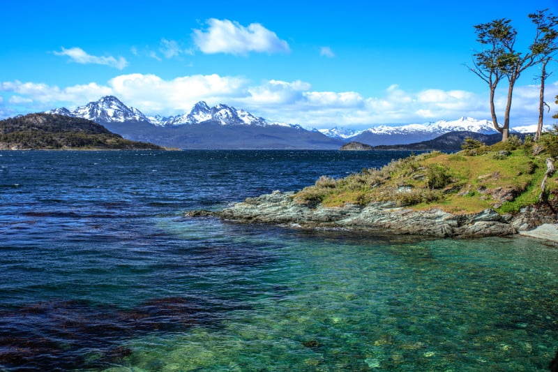
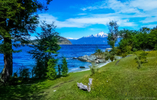
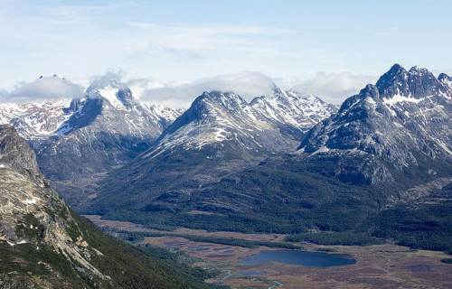
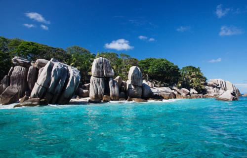
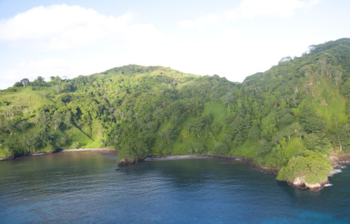
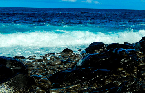
Tierra del Fuego

CCL: http://bit.ly/2xLZ0ap
Tierra del Fuego Facts
- Our third choice for inclusion in this article about 5 Incredible South American Islands is the breathtaking Tierra del Fuego.
- Perhaps most notably, the breathtaking location tops the list of many as one of the most beautiful spots on earth. The truly astounding location holds this high status despite its highly rugged landscape.
- In addition, this mesmerizing location also serves as home to numerous species of animals and plants. Furthermore, to make this even more awesome, some of the plants evolved as completely unique in nature.
- This stunning location constitutes one of the most visually striking archipelagos in the world. However, most of its total area consists of one larger island, and a group of numerous much smaller islands.
- Despite the extreme ruggedness of much of its terrain, this site nevertheless also shows evidence of a rather surprising past. That’s because it shows signs of human habitation going back more than 8,000 years.
CCL: https://bit.ly/36YrPPU
Tierra del Fuego Physical Description
This amazing archipelago of Tierra del Fuego principally consists of the one large island, going by the same name as the archipelago. The stunning primary island itself is often simply referred to as either Tierra del Fuego or Isla Grande. The one island alone has a total area measuring roughly 18,572 sq mi (48, 100 sq km).
As can easily be seen, this breathtaking location boasts an incredible array of impressive landscapes. These marvels of Nature include such features as numerous bays and channels. But, amazingly, the island even holds several glaciers. Some of the small, ancient glaciers even extend all the way to the ocean.
Of further interest remains the fact that the topography can be divided into four regions. These consist of an outer archipelago region, a mountain region in the south, a plains region, and a sub-Andean zone between the last two zones. Each has its own separate and quite distinct geography.
CCL: http://bit.ly/2zBWbKi
Tierra del Fuego Location, Climate, and Life
Firstly, the wondrous main island of Tierra del Fuego is actually divided between two different countries in South America. The country of Chile controls 61.43% of the land area. Meanwhile, the country of Argentina controls the rest.
Perhaps even more surprising than other factors is its climate. That’s because this rather incredible spot on the earth possesses a subpolar oceanic climate. Its summers typically remain short and cool, while winters are long, wet, and moderate.
However, the southernmost of the islands in the archipelago possess a sub-antarctic climate, similar to such locations as the Aleutian Islands. Here, the harsh weather conditions makes any appreciable growth of foliage virtually impossible.
As a result of this, only 30% of the islands possess forests of any size. Yet, many of the the tree varieties that do grow bear fruit. Much of the remaining area comprises either steppes or semi-arid deserts, creating an overall harsh landscape.
Finally, and somewhat surprisingly, a comparatively large number of animal species appear to thrive in the region. These include such creatures and foxes, seagulls, penguins, condors, owls. Several varieties of whales also call the local waters home.
CCL: https://bit.ly/2vUDWRf
Cocos Island Facts
- Taking the fourth spot on our list of 5 Incredible South American Islands is the remarkable spot known simply as Cocos Island.
- First of all, it must be pointed out that the truly amazing island remains remarkable for several different reasons. For starters, this fabulous location represents a small but impressive island with a most unusual origin. That’s because the stunning wonder of geology formed due to the occurrence of both volcanic and tectonic activities.
- Secondly, however, the feature actually constitutes the only emergent island of what scientists name the Cocos Plate. This represents one of the earth’s minor tectonic plates, of which many exist. Furthermore, the most recent scientific testing established the age of the oldest rocks on the island to be in the approximate range of 1.91-2.44 million years.
- The first known sighting of the island occurred in the year 1526. The credit for the discovery went to the Spanish navigator Juan de Cabezas. In modern times, the nation it forms a small part of designated the entirety of the island as a National Park. As a result, the island has no permanent inhabitants, except for a small group of park rangers.
CCL: https://bit.ly/381696P
Cocos Island Physical Description
Most notably, the magnificent Cocos Island boast a composition consisting primarily of basalt. This, in turn, formed from cooling lava. In addition, the terrain of the site remains quite mountainous and highly irregular. It does boast a mountain whose height measures roughly 1,888 ft (576 m), named Cerro Iglesias.
In spite of its largely mountainous character, flatter areas measuring between 656-853 ft. (200-260 m) in elevation do occur. These mainly appear in the central part of the island, however. These areas perhaps represent a transitional stage of the geomorphological cycle of V-shaped valleys.
Four bays also appear here. Three of them in the north side, named Wafer, Chatham, and Weston. Cocos Island also has a large number of short rivers and streams that drain the abundant rainfall into these. Due to a large range of roughly 300-foot (91.4 m) high cliffs that ring much of the island, the easiest point of entry is at Chatham Bay.
CCL: https://bit.ly/2S3iNNn
Cocos Island Climate
The largest rivers on the island bear the names of Genio and the Pittier. These drain into Wafer Bay. The mountainous landscape and the tropical climate combine to create more than 200 waterfalls throughout the island.
The island’s soils mainly consist of entisols. These remain highly acidic and could be easily eroded by the island’s high rainfall on the steep slopes if it was not for the dense forest coverage. Root systems, therefore, remain very critical in protecting from erosion.
Cocos Island is famous for the cloudiness and precipitation that appears constant throughout the year. This makes the climate humid and tropical with an average annual temperature of 74.5 fahrenheit. (26.6 C). It also has an average annual rainfall of more than 275 in (699 cm).
CCL: https://bit.ly/3bgjgDj
Cocos Island Location, Flora, and Fauna
The marvelous Cocos Island sits roughly 340 mi (550 km) from the Pacific shore of Costa Rica, in South America. With an area measuring about 9.2 sq mi (23.8 sq km) and a perimeter of roughly 14.4 mi (23.3 km), this island has an almost rectangular in shape
Amazingly, a number of oceanic currents from the central Pacific Ocean converge on the island. These also, understandably, have an important influence on the weather. As a result, Cocos Island is home to dense and exuberant tropical moist forests.
It does, in fact, constitute the only oceanic island in the eastern Pacific region with such rainforests and their characteristic types of flora and fauna. Further, the cloud forests at higher elevations also remain unique in the eastern .
Finally, evidence indicates that the island never formed part of a continent. Therefore, the flora and fauna arrived via long-distance dispersal from North America and South America. Cocos Island has, therefore, a high proportion of unique endemic species.
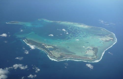
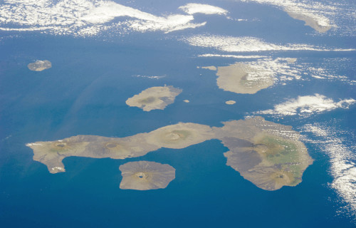
Galapagos Islands
Galapagos Islands Facts
- The fifth and final location on our list of 5 Incredible South American Islands, the Galapagos Islands, lands there solely due to random selection.
- Firstly, the truly breathtaking location constitutes a largely pristine archipelago of volcanic islands. Furthermore, this magnificent site also represents a rather incredible marvel of both geology and biology. This fabulous location also remains considered to be a unique location of incomparably vast ecological importance and significance.
- In addition to this, the larger islands and the numerous smaller bodies comprising the archipelago formed in a quite fascinating location. That holds true due to the fact that this marvel of Nature straddles the equator. Therefore, part of the remarkable archipelago lies in the Northern Hemisphere, while the rest lies in the Southern Hemisphere.
- Further, the studies of this breathtaking location by Charles Darwin played a pivotal role in the development of his theory of evolution. Due to the incomprehensible value this archipelago holds to science, it now holds several distinctions. The islands themselves no comprise the Galapagos National Park, and the surrounding waters form Galapagos Marine Reserve.
Public Domain Image
Galapagos Islands Physical Description
Perhaps most notably, the astonishing Galapagos Islands actually includes an extensive array of sites. That’s because it consists of a grand total of 18 primary islands, 3 smaller islands and 107 rocks and islets. Together, the magnificent archipelago also totals an impressive 3,040 sq mi (7,880 sq km) in total area.
In addition, this astounding island chain formed through volcanic activity, like many others in the immediate area. Studies indicate that this process occurred over a period of roughly 20 million years. In fact, it continues to grow slowly, due to ongoing volcanic activity. However, this remains minor in our age. In modern times, the few eruptions have remained minor.
Many of the individual islands and islets also serve as home to one or more volcanoes. Some of these volcanoes remain active even today, though none have erupted violently in modern times. However, two of the islands, Fernandina and Isabela, are still growing through slow volcanic processes.
Galapagos Islands Location and Ecological Importance
The uniquely placed Galapagos Islands straddle both sides of the equator in the Pacific Ocean. More specifically, this location also roughly encircles the center of the Western Hemisphere. This amazing location lies roughly 500 nautical miles (926 km) west of continental Ecuador, in South America.
Only 5 of the islands have a population, all of them sparsely settled. This population totals around 25,000 individuals. None of these constitute a native population, however. Of further interest is the fact that the Galapagos Islands remains one of those few places on earth without a true indigenous people.
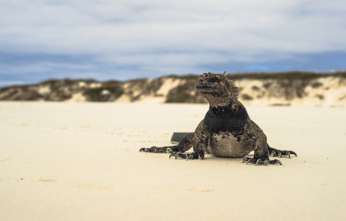
Interestingly, the archipelago does remain extremely well known for its large number of indigenous plant and animal species. In fact, the environmental importance of this unique area is clear from the fact that not only is it a UNESCO World Heritage Site, but it also constitutes a Biosphere Reserve.
Some of the amazing species calling the site home live nowhere else on earth. These include such species as the Galapagos Penguin and the Marine Iguana. Quite sadly, however, various invasive species now form a problem for some of the native species. Also, a total of 27,000 sq miles (70,000 sq km) of the surrounding ocean is a marine reserve, and a National Park.
CCL: https://bit.ly/1p2b8Ke
5 Incredible South American Islands
We truly hope that you have enjoyed this article about 5 Incredible South American Islands. Each of these brings something different to the article, but all remain equally marvelous. However, many of them need our help to preserve their natural beauty for our posterity. Let us do all that we can to keep them as they are, so that our descendants can marvel at and appreciate their natural splendor just as we do.
Check out our other articles on 4 Remarkably Unique Rabbits, Sensational Christmas Namesakes of the World, 5 Phenomenal Sea Turtles, 7 Stunning European Flowering Plants