


CCL: https://bit.ly/1ryPA8o
5 Marvels of New Zealand and Australia
Here, we present to you our choice of 5 Marvels of New Zealand and Australia. These are lands of countless things to amaze us. They give us scenes of incredible beauty and harsh reality, all on the same continent. For the moment, we concentrate our focus on the astonishing works of Nature in the form of geological features. We hope you enjoy!
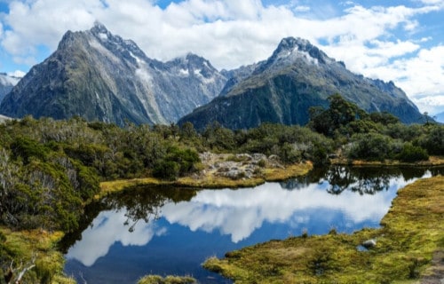
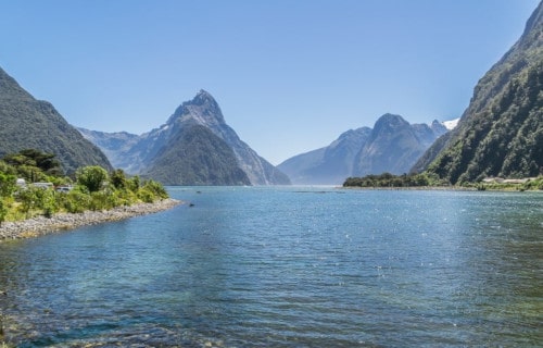
Milford Sound

Milford Sound Facts
- The breathtaking Milford Sound represents a stunning fjord that ranks as the number one travel destination in the world, by numerous sources.
- The highly respected writer Rudyard Kipling himself once referred to this astonishing location as the eighth wonder of the world.
- In addition to its own rather remarkable beauty, the site also serves as home to an astonishing variety of wildlife, including right whales
- area routinely receives copious amounts of rainfall. In fact, it ranks as one of the wettest permanently inhabited regions of the world.
CCL: https://bit.ly/1xMszCg
Milford Sound Physical Description
The gorgeous Milford Sound extends a length of roughly 9.3 mi (15 km). It also remains bordered by enormous and rather sheer rock walls.
In some places along the length of the picturesque fjord, these walls rise to a height of as much as 3,900 ft (1,200 m). Several large individual peaks also line the length. Two of these exceed 4,200 ft (1,280 m) in height.
In addition to such splendor, the magnificent location also boasts two magnificent permanent waterfalls, known as Lady Bowen Falls and Stirling Falls.
After particularly heavy rains, numerous temporary waterfalls also frequently cascade over the steep rocky slopes. Water drenched moss feeds these, and they usually last only a few days, once the rain stops.
At its entrance, this marvel of Nature connects to the Tasman Sea. This occurs at a location known as Dale Point.
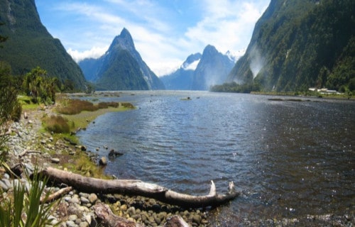
Photo: Joan Campderrós-i-Canas
CCL: https://bit.ly/1ryPA8o
Milford Sound Location, Climate, and Wildlife
The fabulous and world-renowned Milford Sound lies in the southwest portion of New Zealand’s South Island, near Australia. More specifically, it sits within Fiordland National Park.
It also forms part of the Piopiotahi Marine Reserve, and the Te Wahipounamu World Heritage Site. The names derive from the language of the native Maori.
This site also constitutes the wettest part of the country of New Zealand. The region receives an average annual rainfall of about 252 in (6,412 mm). Rainfall totals of as much as 10 in (25 cm) in a single day sometimes occur.
Such a region rather easily plays host to numerous species. Some of these include seals, bottlenose dolphins, and several species each of whales and penguins.
Hot Water Beach
CCL: https://bit.ly/349xXWf
Hot Water B Facts
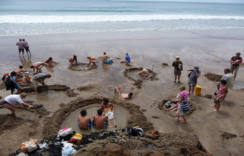
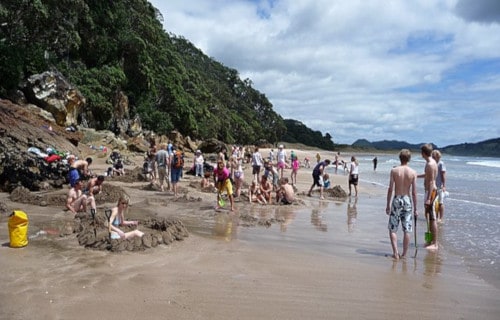
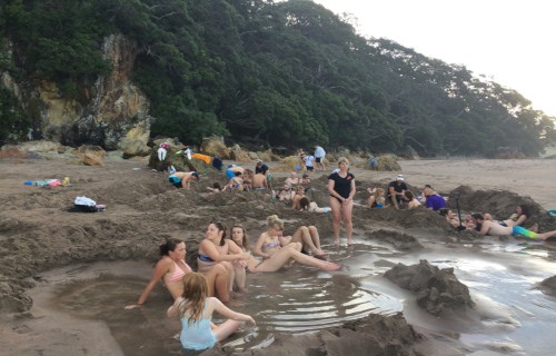
- An outing to the extraordinary Hot Water Beach would likely be the one time you actually want to find yourself in hot water while on a trip to the beach.
- The aptly named beach is an extremely unusual geological interface between the ocean and naturally occurring hot springs. This amazing location forms part of Mercury Bay, in New Zealand.
- During part of the day, the localized hot springs remain submerged beneath the waves. However, for approximately two hours before low tide, and two hours afterward each day, the unique feature of Hot Water Beach appears. Therefore, you must catch it at just the right time.
CCL: https://bit.ly/3oHRuqv
Hot Water Beach G Nature
Hot Water Beach owes its nature to the presence of underground hot springs situated almost directly beneath the small beach.
The hot water rarely does more than slightly bubble above the surface on its own.
However, digging even slightly into the sand of Hot Water Beach will cause the cavity to be filled with hot water.
The heated water filters up from two small fissures situated quite close to each other. The water from the hot spring sometimes reaches temperatures of as much as 147 F (64 C).
CCL: http://bit.ly/2xQPH8p
Hot Water Beach Tourism and Dangers
Unsurprisingly, the uniqueness of this beach has made it a popular vacation spot for both local inhabitants and tourists. Approximately 700,000 people visit the site annually.
The spot does have its perils, however. Even during low tide, Hot Water Beach sits in close proximity to the waves, which can be large and powerful.
As if this wasn’t enough, powerful rip currents also quite commonly occur in the area.
Groupings of large rocks also sit just offshore. Though lifeguards do watch the area, officials wisely recommend that only highly experienced swimmers or surfers venture beyond the beach itself.
Ebor Falls
CCL: https://bit.ly/3fTOO4Y
Ebor Falls Facts
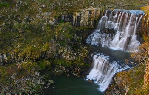
- Ebor Falls is a beautiful waterfall near Ebor, in the New England region of New South Wales.
- The falls represent a cascade waterfall and sit on the Guy Fawkes River. They are also a highly popular tourist attraction within the Guy Fawkes River National Park.
- A number of viewing platforms also exist and the area has been protected since 1895, originally as part of a recreation reserve.
- As a result of its great beauty, an average of roughly 80,000 tourists visit the falls annually.
CCL: https://bit.ly/2R9kafI
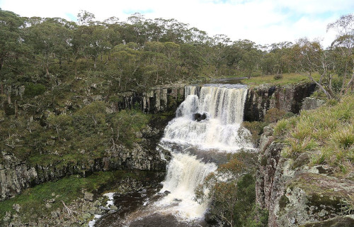
Ebor Falls Physical Description
Ebor Falls is a rather moderate flow waterfall and sits at an altitude of 4,232 ft (1,290 m) above sea level.
The geology of the underlying rock is also predominately basalt. The black color of the basalt makes for a striking background as the water plunges over the falls.
The combined height of the two sections of Ebor Falls also measures about 377 ft (115 m). About 2,000 ft 600 m) downriver from the second half of the fall, is yet another plunge.
This one also falls into a steep gorge, filled with forest. What a beautiful sight.
CCL: https://bit.ly/3wH14N0
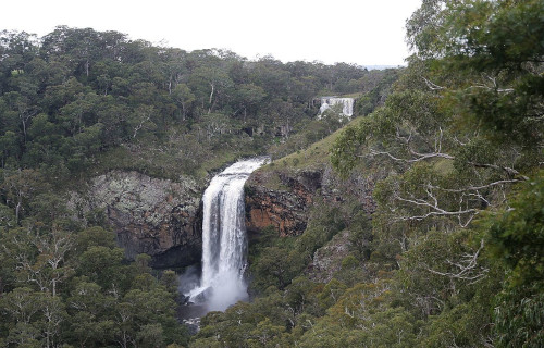
Ebor Falls Underlying Geology
The breathtaking Ebor Falls are a particularly unique geological formation. They have formed at a point where ancient lava flows joined, which is the source of the underlying basalt.
The basalt averages roughly 164 ft (50 m) in thickness but in places, it is as thick as an impressive 984 ft (300 m).
The basaltic bedrock was formed from a particular type of lava, one rich in magnesium and iron, and is known as mafic lava.
On the lower section of the falls, large vertical basalt columns are easily visible. Large blocks of volcanic stone are also abundant under and around the waterfall.
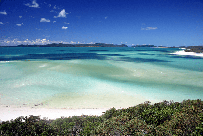
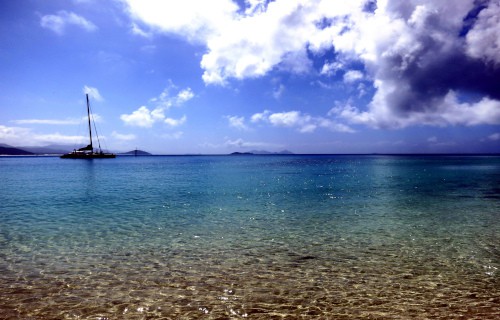
Whitehaven Beach
CCL: https://bit.ly/1ryPA8o
Whitehaven Beach Facts
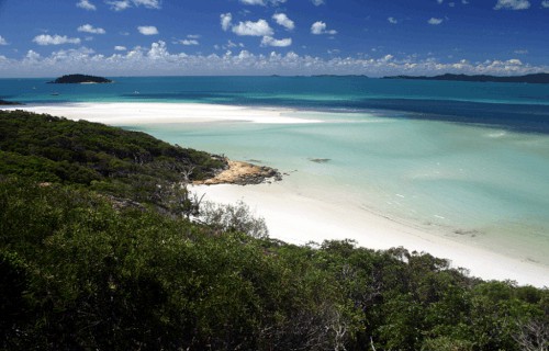
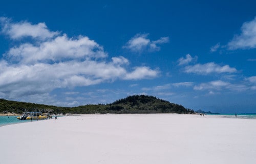
- Whitehaven Beach remains a rather spectacular 4.3 mi (7 km) stretch of the shoreline of the Whitsunday Islands.
- In addition, the island is accessible by boat from the mainland tourist ports of Airlie Beach, Shute Harbor, and the upscale Hamilton Island.
- The beach was also discovered in 1879, by Staff Commander EP Bedwell who also gave the beach its name.
- This was one of the many names from the British county of Cumberland that Bedwell brought to the area.
- It was also James Cook who gave the Cumberland island group its name, in 1770.

CCL: https://bit.ly/1ryPA8o
Whitehaven Beach Geography
The phenomenally beautiful Whitehaven Beach is also quite famous for its white sands which consists of 98% pure silica giving the beach a bright white color.
Unlike regular sand, the sand on Whitehaven Beach does not retain heat.
This makes it rather pleasantly comfortable enough to walk barefoot on a hot day. We tried and tested it.
CCL: https://bit.ly/1E6HPMf
Whitehaven Beach Distinctiveness
The geology of the island itself also shows little or no trace of silica. Thus the sands most likely came to the beach via prevailing sea currents.
But, this has likely occurred over a period of several million years.
The sand of Whitehaven Beach is also extremely fine. This means that it can damage electronic equipment such as telephones and cameras.
It is, however, extremely useful for polishing fine jewelry.
CCL: http://bit.ly/2xQPH8p
Whitehaven Beach Preservation Efforts
In 2008, the beach also gained worldwide fame as the cleanest beach in Queensland, Australia, per Keep Australia Beautiful. This was part of the Clean Beach Challenge State Awards.
In July 2010, CNN.com named the beach the number one Eco-Friendly beach in the world. Dogs are not permitted there and cigarette smoking is also prohibited.
Moeraki Boulders
Moeraki Boulders Facts
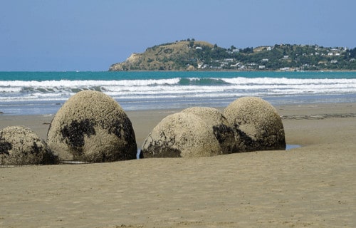
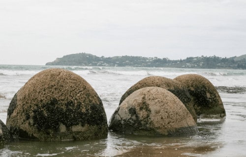
- The Moeraki Boulders comprise an unusual geological feature comprising a rather startling collection of large boulders along a section of beach on the coast of Otago.
- The majority of the surprising boulders lie in large clusters. Each of these boulders also measures roughly spherical in shape.
- In addition, some of these geological marvels also possess large fissures, as well.
- These fascinating and rather remarkable features occur in the sovereign island nation of New Zealand.
- Fortunately for posterity, the section of beach that they appear on now forms a protected reserve.
CCL: https://bit.ly/1p2b8Ke
Moeraki Boulders Physical Description
The eye-catching Moeraki Boulders have long fascinated those who encounter them. The great majority of them fall into two distinct size ranges.
Approximately 30% of them measure between 1.6-3.3 ft (0.5-1.0 m) in diameter, while the vast majority of the rest all stay in the range of 4.9-7.2 ft (1.5-2.2 m).
Yet they do have one basic factor in common. All of the boulders display a dark gray color, due to the particular nature of their composition.
Most of these unique objects have a roughly spherical shape, yet a rather small percentage of them possess a slightly elongated shape.
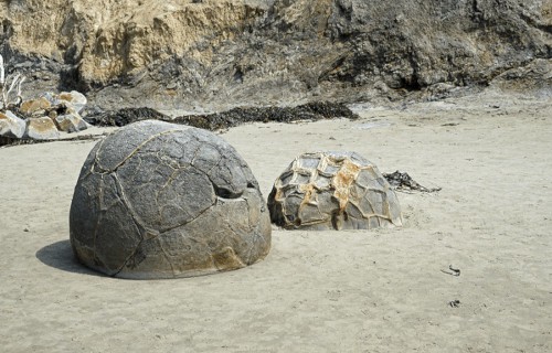
Moeraki Boulders Composition and Origin
The astonishing Moeraki Boulders formed as septarian concretions. They consist of a combination of silt, clay, and mud, bonded together by calcite.
Beneath the extremely hard outer shell, they remain relatively soft, as they are less compacted.
A few have also broken open, and their interiors eroded by the elements. Further, the inner cores of many of these formations have linings of calcite crystals.
The Moeraki Boulders were formed during the Paleocene Era as the calcite deposited in the mud on the seafloor. As further mud layers deposited, the pressures began their formation.
The process required millions of years. Coastal erosion then exhumed them from the sea mud.
5 Marvels of New Zealand and Australia
CCL: https://bit.ly/1ryPA8o
Here you have seen our listing of 5 Marvels of New Zealand and Australia. Of course, this list barely scratches the surface of the wonders of geology that to be seen in these incredible lands. Yet these wonders remain fragile, and some of them face the imminent danger of loss due to the actions of mankind. We must do all we can to protect and preserve these wonders of Nature for our posterity.
Check out our other articles on 9 of the Weirdest Animals on Earth, 8 Swoon-Worthy Caves, Wonderful Wild Cats of the World