


We certainly hope that you enjoy this article on 5 Natural Marvels of Iceland. While natural beauty appears in all sections of our world, this region just seems to have more than its share. It also comes in many varied forms, to be certain, but all display extraordinary beauty. Please, read on now, and partake of the wonder and majesty that this corner of the globe has been blessed with.
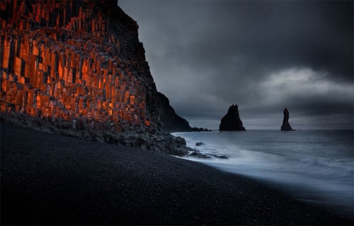
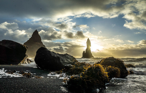
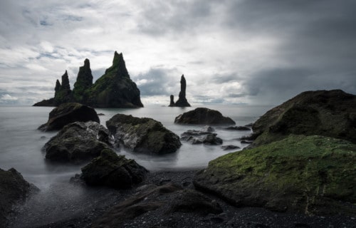
Reynisfjara Beach
Reynisfjara Beach Facts
- Leading off our listing of 5 Natural Marvels of Iceland is the eerily beautiful site known as Reynisfjara Beach.
- Without a doubt, this magnificent site ranks as one of the most unusual beaches in the world, and also one of the most isolated known to man.
- But its isolation also helps this geological wonder to remain relatively pristine. Very few tourists choose to brave the environmental conditions of its location, so tourism stays rather limited.
- We have been there – check out our photo in our OBP Around the World gallery.
- The waves in the area stay extremely powerful and rather unpredictable. Previously, numerous fatalities also occurred there among those attempting to swim in the dangerous waters.
- As a result of the unique landscape, numerous science fiction and horror movie filmmakers continue to use the site for filming movies.
CCL: https://bit.ly/3qHe0AO
Reynisfjara Beach Location and Geological Description
Reynisfjara Beach sits roughly 112 mi (180 km) from Reykjavik, in Iceland, in Europe, and faces the cold, open waters of the northern Atlantic Ocean. This incredible site stretches for about 3.1 mi (5 km).
Most noteworthy is the fact that the beach actually has an astonishing black color. That occurs due to is composition of basalt, gradually eroded with the relentless passage of time.
In addition, the location continues to be famous for the presence of incredible stone features just offshore. These constitute black basalt columns known as Reynisdrangar, which began as enormous volcanic boulders.
Since their expulsion from the earth ages ago, erosion occurred from the action of wind and waves. This subsequently created the incredible shapes found there today.
CCL: http://bit.ly/2JszWtI
Reynisfjara Beach Climate and Ecology
The climatic conditions at Reynisfjara Beach remain extreme, usually enough to dissuade investigation by all but the most ardent beach fans.
It also rains there an average of 340 days per year, making it the wettest place in Iceland. And it already rains in Iceland a lot.
One magazine named the location one of the 10 most outstanding non-tropical beaches on earth, in 1991. This was despite (or perhaps as a result of) these conditions.
Surprisingly, rather than being devoid of wildlife, the location teems with a variety of birds. These include fulmars, guillemots, and puffins, showcasing the extraordinary adaptability of Nature.
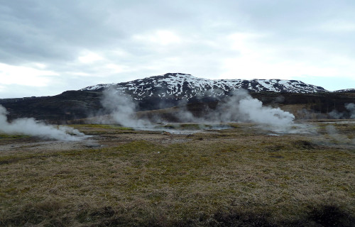
Haukadalur Geothermal Area
CCL: https://bit.ly/3jAyTfr
Haukadalur Geothermal Area Facts
- The second location among our 5 Natural Marvels of Iceland is the astonishing region known as the Haukadalur Geothermal Area.
- This breathtaking site remains an extraordinary region of geological beauty in the southern portion of Iceland.
- In fact, one of the geysers found in the area actually represents one of the first geysers that modern man discovered.
- In addition, the earliest known recorded mention of the spectacular landscape features was in 1294. Further, at that time, an earthquake activated numerous hot springs within the region.
- The region has also been a major attraction for tourists since the 18th century and continues to thrive in that regard.
CCL: http://bit.ly/2QZT99x
Haukadalur Geothermal Area Origins and Nature
The Haukadalur Geothermal Area originally formed at the end of the last Ice Age. Yet, occasional earthquakes in the region continue to alter its nature even today. The last such earthquake in the region occurred in July of 2000.
There are currently 40 geothermal based features present in the remarkable region. All of these are volcanic in nature. They include multiple geysers, hot springs, fumaroles, and mud pots.
The largest of the geysers is Strokkur and many of the geysers are comparatively regular in the timing of their eruptions.
CCL: https://bit.ly/3ArMDim
Haukadalur Geothermal Area Physical and Biological Distinctiveness
Several of the small springs in the area are quite unique. The water within them is sodium bicarbonate thermal water due to the extremely high concentrations of sodium bicarbonate.
These same streams in the Haukadalur Geothermal Area also contain comparatively high concentrations of radon.
Living within this unique environment are numerous species of microorganism and algae that have adapted to survive within the unique water and extreme heat.
In fact, many of them are incapable of surviving in water temperatures below 158 F (70 C).
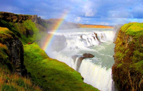
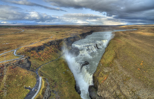
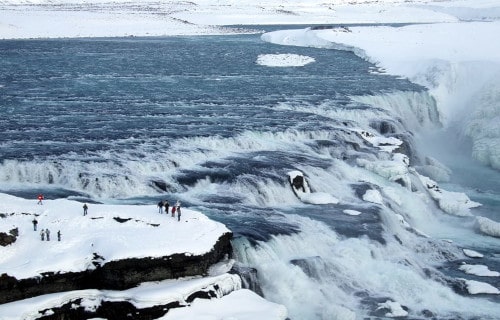
Gullfoss
Gullfoss Facts
- The third entry in this article about 5 Natural Marvels of Iceland is one of mesmerizing beauty, the location known simply as Gullfoss.
- Firstly, Gullfoss serves as the name of a spectacular waterfall located in the southern section of Iceland. This astounding marvel of geology also forms an integral part of the Hvita River.
- Further, the surrounding terrain stays extremely rugged, and relatively untouched by man. The rapidly flowing water of Gullfoss originates from the second largest glacier in Iceland, named Langjokull.
- Additionally, in terms of tourist interest, this site is the most popular waterfall in all of Iceland. This holds true for multiple reasons, as the stunning location holds great natural beauty.
- Due to a unique combination of factors, on days when the sun is shining, a rainbow is visible throughout the day. However, on some occasions, multiple rainbows appear visible as well.
CCL: https://bit.ly/368mjMj
Gullfoss Physical Description
Most notably, Gullfoss is situated in a unique and isolated location. The southward-flowing river takes a decidedly sharp right turn about o.62 mi (1 km) before reaching the waterfall. Then it rapidly flows into a uniquely curved, three-step staircase.
Subsequent to that, it further plummets in two distinct stages. A drop of about 36 ft (11 m) constitutes the first of these. Furthermore, a second drop measuring roughly 69 ft (21 m) represents the second of them.
Finally, these two drops take place within a crevice 105 ft (32 m) deep, and only 60 ft (20 m) wide. The crevice itself also measures about 1.6 mi (2.5 km) in length and flows perpendicular to the river itself.
CCL: https://bit.ly/1ryPA8o
Gullfoss Cultural Significance
Additionally, Gullfoss holds a special place in the culture of the region. Throughout much of the first half of the 20th century, there was great interest in utilizing it as a source of hydroelectric power.
Foreign investors purchased the rights to the waterfall for just that reason. However, the daughter of the man who owned those rights before protested vehemently for the preservation of the pristine beauty of Gullfoss. After years of court battles, the young woman lost her case.
However, the foreign owners had exhausted their funds, partly due to the expense of the trials. As a result, the rights were sold to the government, which promptly established a conservation area to protect it.
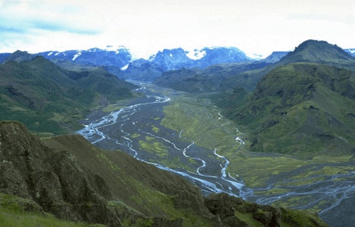
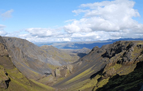
Thorsmork
CCL: https://bit.ly/2u410Z3
Thorsmork Facts
- The next of our 5 Natural Marvels of Iceland is the incredible wonder of geology that bears the name of Thorsmork.
- It forms a beautifully rugged mountain ridge located in a rather rugged section of Iceland. This geological marvel bears the name of the Norse god Thor, and the name, therefore, translates as Thor’s Forest.
- Locals often use the same name to refer to the greater overall region in which the ridge sits. The site also sits in the southern portion of the country, lying between the glaciers of Eyjafjallajokull and Tindfjallokull.
- Further, this picturesque ridge remains surrounded by three rivers. Locals named these named Prouga, Krossa, and Markarfljot.
- Yet another glacier remains at one end of Thorsmork that has the name of Myrdaljokull.
- The nature of the landscape makes the region rather popular with hikers and climbers. However, this the potential for great danger, as the site remains rather active.
- In 2010, the nearby peak Eyjafjallajokull notoriously erupted, creating widespread disruption of air travel throughout much of Europe.
CCL: https://bit.ly/1E6HPMf
Thorsmork Climate and Conditions
The unique environmental conditions present in Thorsmork led to the formation of a climate much more temperate than most of southern Iceland. This has led to the development of a rather unique and delicate ecosystem in the region.
Within the shelter and protection of the valley, a variety of vegetation grows in great abundance. The most prevalent types of plants include Birchwood, ferns, and moss, along with a wide variety of small shrubs.
Fed by the melting glaciers, numerous waterfalls, large and small, also developed within Thorsmork. Much of the region was later inundated by a layer of volcanic ash from the aforementioned eruption in the spring of 2010.
This occurred when the nearby volcano Eyjafjallajokull erupted, to the great surprise of many experts. It required several months before the rather delicate local climate returned to normal.
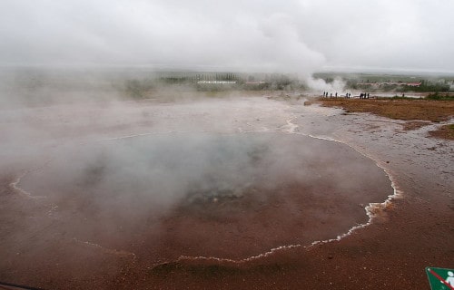
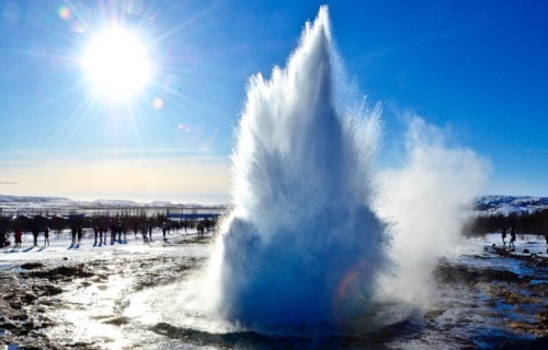
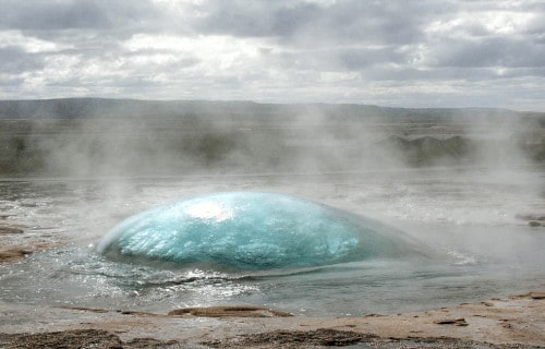
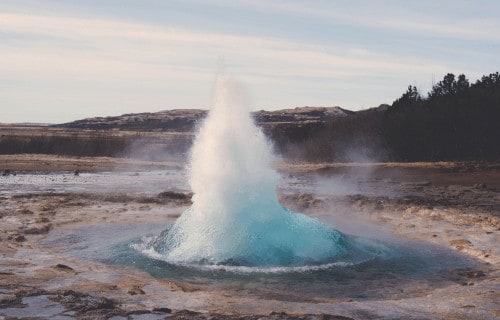
Strokkur Geyser
CCL: http://bit.ly/2OUHszC
Strokkur Geyser Facts
- The final wonder that we have chosen to list among these 5 Natural Marvels of Iceland is the awesome Strokkur Geyser.
- This incredible geothermal feature is a powerful fountain geyser found in a geothermal area in a remote and sparsely populated portion of Europe.
- The beautiful and extremely regular geyser remains one of the most famous of its kind within the region in which it formed.
- Further, this marvel of geology erupts in a steady frequency range of between 4-8 minutes. Variations in the schedule rarely occur.
- This lovely geyser also remains one of the few known geysers to erupt with a regular frequency. Another is located in the United States.
- This has, quite understandably, made it a leading tourist attraction in the region.
CCL: https://bit.ly/24dGLTK
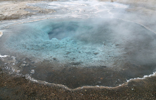
Strokkur Geyser Physical Description
Eruptions of Strokkur Geyser attain an average height of between 49.2-65.6 ft (15-20 m). Yet exceptional occurrences occasionally attain a height of as much as 131 ft (40 m).
It also comprises part of the Haukadalur valley area. There, numerous other geothermal features also exist. These include fumaroles, mud pools, and other geysers that continue to be located around it.
Shortly before eruptions, the pool of hot water fills and then pulses up and down rhythmically. Following this, a large bubble forms, and then the eruption spews forth.
Strokkur Geyser Location and History
Most notably, geological evidence indicates that Strokkur Geyser formed roughly 1,000 years ago, subsequent to an earthquake in the geologically active region.
The earliest recorded reports of its activity date back to the year 1294. At an uncertain time after this, another quake deactivated the site.
In 1789, yet another quake reactivated it. It also subsequently remained active until 1896 when still another earthquake deactivated it once again.
In 1963 local residents succeeded in unblocking Strokkur Geyser once again, and it has remained active since that time.
This constitutes the only recorded instance of human actions intentionally creating or reactivating a geyser.
Finally, this wonder of Nature, like the others on this list, formed in what now constitutes the country of Iceland. This area is beside the Hvita River, in the southwest portion of the country.
CCL: http://bit.ly/2JszWtI
We certainly hope that you have enjoyed this article on 5 Natural Marvels of Iceland. Sites such as these, serve as proof that great natural beauty exists in even the most remote parts of the world. Nature created the beauty that surrounds us, but it remains up to us to make every effort to preserve it for future generations to enjoy.
Check out our other articles on Breathtaking Asian Species, Incredible Sharks of the World, North American Gulches and Canyons, Earth’s Extremely Threatened Flowers