


CCL: https://bit.ly/2GS08gY
We greatly hope that you will enjoy this article about 5 Obscure United States Geological Gems. It certainly thrilled us to compile it for you, our readers. This region of the world seems to have been blessed more than some with natural wonders in many forms.
Many of those natural wonders are now quite well known, of course. Others, however, remain veiled in obscurity, some to greater or lesser degrees. It’s those that we present to you herein, to increase awareness of the existence, as well as their stunning beauty.
Ramona Falls
CCL: https://bit.ly/3g1LrqZ
Ramona Falls Facts
- Leading off this article about 5 Obscure United States Geological Gems comes the stunningly beautiful formation known to those who do know it as Ramona Falls.
- The breathtaking geological formation known by this simple name remains one of the most beautiful cascades known to man. Part of its extreme beauty comes from the fact that it also has one of the most distinctive appearances of any such formation.
- To many people, this marvel of Nature looks like someone blended a waterfall with the inside of a beehive. Not so coincidentally, the type of remarkable rock formation over which it flows many people know as a honeycomb structure.
- The first reported sighting of this stunningly beautiful waterfall in modern times, amazingly, did not occur until 1933. At that time, a Forest Service employee named John E. Mills came across it and named it. He did this while creating a trail.
- The incredible flow of water that he named Ramona Falls had, however, long been known by local populations of Native Americans. Today, the area may only be accessed via a hike along a rugged trail. This helps account for its being little known.
- Yet, the region in which the wonder of geology lies now forms part of the magnificent Pacific Coast Trail. In fact, the spot also represents the junction of two extremely popular hiking trails. These bear the names the Timberline and the Ramona Falls Trail.
CCL: https://bit.ly/2Vo739a
Ramona Falls Physical Description
The truly breathtaking cascade referred to simply as the Ramon Falls never fails to dazzle those who see it. It does not do so due to seer physical size, though. That’s because this wonder of Nature has a total height that measures approximately 120 ft (37 m).
Yet this frequently overlooked, but nonetheless awesome fall also possesses other, highly respectable, and to some, surprising, statistics. Among these remains the fact that the gorgeous flow of water sits at an elevation that measures 3,560 ft (1,090 m) above sea level.
The staggering beauty of Ramona Falls derives from not simply its height. This only ranks as average, but it has remarkable structure. It’s composition of a series of interlocking, hexagonal-shaped columns creates a multi-layered visual effect that leaves one breathless.
CCL: https://bit.ly/2YC51UR
Ramona Falls Location, Formation, and Nature
The awe-inspiring work of Nature named Ramona Falls formed in a truly picturesque, and somewhat out of the way, part of the world. This geological gem formed on the western side of what’s now known as Mount Hood, in the state of Oregon, in the United States.
More precisely, however, this beautiful cascade also finds itself in an area already so admired for its beauty that it’s garnered federal attention. The waterfall sits within the boundaries of the Mount Hood National Forest, though it remains little known to tourists.
A large component of the great beauty of the site remains the distinctive nature of the rocks over which the water flows. These formed as the result of an ancient volcanic flow, although even volcanologists differ as to exactly when in the past this action occurred.
At the time of the eruption, the flowing lava, largely basaltic in nature, slowly cooled. As it did so, it formed countless vertical hexagonal columns. Erosion later created the distinctive honeycomb pattern, over which the water flows with such beauty now.
The flow of water for the fabulous Ramona Falls itself originates from nearby Mount Hood, although rainfall obviously adds to this flow at times, and in varying amounts. There, the steady process of glacial melt provides a steady stream for a moderate flow.
Sliding Rock
Public Domain Image
Sliding Rock Facts
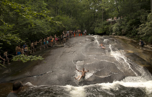
- Next up among our choices for inclusion in the article about 5 Obscure United States Geological Gems comes the marvelous formation known as Sliding Rock.
- This distinctive marvel of Nature bears the appropriate common name that it does for reasons that appear readily apparent to those who visit it. The time of its original discovery by the local Indigenous People, though, remains shrouded in mystery.
- The aptly-named formation, furthermore, forms a small yet marvelous slide-type waterfall. This geological formation formed in a region of the globe well known for its natural beauty. The formation formed in what now consittutes western North Carolina.
- Slide-type waterfalls do not rank as rare, yet few exist that have the length and breadth of this one. This makes it stand out from the others. The name derived from the fact that people can slide the gently sloped length of the waterfall with little risk of injury.
- Certain weather conditions in the region, however, occasionally make the site temporarily unsafe, especially to younger children. During the summer, when tourists most commonly appear, the US Forest Service periodically provides a lifeguard.
- The beautiful, as well as enjoyable, Sliding Rock represents a natural marvel little known outside of its immediate region, however. This, though, actually serves to provide it with a modicum of protection, by limiting the annual tourist draw to the site.
CCL: https://bit.ly/1p2b8Ke
Sliding Rock Physical Description
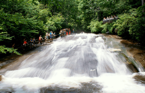
The magnificent formation known as Sliding Rock quickly amazes an dimpresses those who encounter it. The site does not do so, however, due to sheer physical size. Though it’s quite large for its type of formation, it nonetheless doesn’t have extreme measurements.
That’s due to the fact that it measures roughly 60 ft (18.3 m) in total length. The width of this wondrous spot to experience also varies moderately significantly, That’s because this ranges from between roughly 20-40 ft (6.1-12.2 m) over the length of the waterfall.
Originating from mountain springs high in the beautiful Appalachian Mountains, which form Looking Glass Creek, the water temperature rarely rises above 50-60F (10-15.6C) even during the summer. This accounts for a largfe portion of its long-lived popularity.
At the base of the waterfall yet another pleasant feature occurs. More precisely, in this location a small plunge pool formed long ago. This measures roughly 30 ft (9.1 m) in width, and averages between 6-8 ft (1.8-2.4 m) in depth depending on the time of year.
The flowrate of the formation naturally varies, depending on environmental conditions, however. Overall, though, that rate remains respectable, given its moderately small size. Roughly 11,000 gallons (41,640 liters) flows over Sliding Rock per minute, on average.
CCL: https://bit.ly/1jxQJMa
Sliding Rock Popularity and History
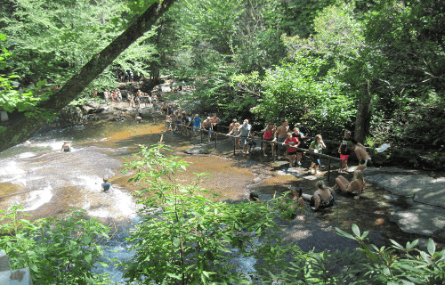
The marvelous splendor of Sliding Rock formed in a region already highly appreciated and valued for its abundance of natural beauty. More precisely, the intriguing geological formation constitutes part of Looking Glass Creek, located in the Pisgah National Forest.
The area also serves, quite understandably, as a popular regional tourist site that the US Forest Service monitors and maintains. Parking areas, changing facilities, and a restroom have been provided for the influx of tourists. The site’s also carefuly monitored for its care.
The government agency does, however, charge a small fee for access to the site between Memorial Day and Labor Day weekends. This small fee, though, pays for the lifeguards, who are only on duty during this peak period, to allow for a safe experience by visitors.
For the moment, the date of origin of Sliding Rock remains a mystery to researchers. The surrounding mountains, though, rank among the oldest on the entire planet. It’s likely, however, that the formation of this specific feature occurred relatively recently.
Long before European settlers arrived in the area, the waterfall constituted a popular location for cooling off on hot summer days for the indigenous Native American tribes. Sadly, however, no record of exactly when the locals first noticed the site exist.
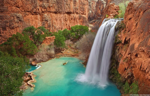
Havasu Falls
CCL: https://bit.ly/2GS08gY
Havasu Falls Facts
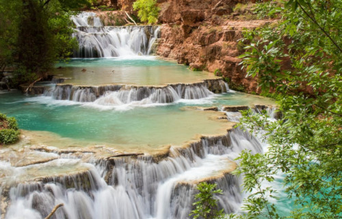
- The third entry into this collection of 5 Obscure United States Geological Gems places there only due to random selection, the magnficent Havasu Falls.
- Without doubt, the mesmerizing flow of water easily ranks as one of the most beautiful waterfalls in the world. It also goes by the name of Havasupai Falls. By either name, the site also remains one of the most difficult falls in the world to access.
- That lamentable fact, however, serves to provide it with at least a measure of protection, to preserve it in its natural state. In point of fact, two very specific factors currently serve to limit access to this marvel of Nature, aiding its preservation.
- The site sits on tribal land belonging to a small group of Indigenous Peoples. Understandably, the tribe strictly regulates the number of visitors to the location. Access to the site remains limited to those acquiring a permit from local authorities.
- In addition to this requirement of man, the very nature of the surrounding terrain also serves to make it difficult to access. Although this makes it more difficult for those who appreciate Nature to view it, this fact can certainly be respected.
- The local topography makes it nearly impossible to gain access to the site from the ground without the knowledge of the indigenous inhabitants of the region. Its sheer natural beauty gives this awesome wonder of Nature a truly powerful allure.
- This trait has garnered breathtaking Havasu Falls international attention several times, in some ways. With the permission and cooperation of local authorities, its beauty has been featured in both a Hollywood movie, and a music video.
CCL: https://bit.ly/31kFWh4
Havasu Falls Physical Description
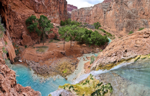
The fame of the truly stunning Havasu Falls derives purely from its natural beauty. This notoriety, although certainly well-deserved, has no basis in its physical size. This holds true due to the fact that the waterfall represents no more than an average sized cascade.
This status pertains to both its height and width. For one thing in particular, the waterfall itself consists of a single stage, much like the vast majority of similar features scattered throughout the world. In its case, the water plunges a total of about 100 ft (30 m).
It also does so over a series of several vertical cliffs. These cliffs have a composition primarily consisting of dark reddish sandstone. Without a doubt, the most visually striking feature of Havasu Falls remains the breathtaking color of the water itself.
This occurs due entirely to the fact that the underlying rock strata contains high concentrations of calcium carbonate. This natural compound slowly but steadily distills into the flow of water, continually providing that water with an astounding aquamarine color.
Havasu Falls Location, Formation, and History
Surprisingly, Havasu Falls sits within another larger, and far better known, natural marvel. That other wonder of Nature is none other than the Grand Canyon itself. The waterfall, therefore, formed in what now constitutes the state of Arizona, in the United States.
Along with the canyon, this waterfall forms another of the great natural wonders of North America. The stunning cascade formed on what became tribal land of the Native American tribe, the Havasupai. The tribe has lived at the site for more than 800 years.
This astonishingly beautiful cascade also formed through a unique, but highly effective, combination of two processes. These factors in its creation consisted of both slow erosion over time, and rapid erosion due to the occurrence of flash floods in the area.
The high levels of calcium carbonate in the water also leaves deposits as it flows along. Over time, these minerals built up in several places, forming small but magnificent travertine steps. The frequent flash floods in the region often changes these, however.
Sometimes one or more of these beautiful but very delicate features becomes reduced due to the force of the flood, or even demolished, to be reformed later. Because of the occurrence of the same flash floods, the nature of the waterfall itself often changes.
Prior to one powerful flood, Havasu Falls flowed in one broad sheet. Since then, the form of the flow has changed on several occasions. Currently, it flows in a single sheet of water, whose temperature remains a near-constant 70 degrees Fahrenheit (20 Celsius).
Lost Lake

Lost Lake Facts
- Appearing next in this listing of 5 Obscure United States Geological gems is the most mystifying of the group, the aptly-named Lost lake.
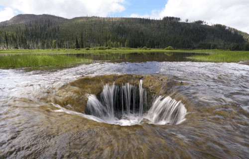
- The body of water popular as Lost Lake represents a truly fascinating geological oddity. That holds true due to the fact that each year the entire lake disappears during the winter. Yet, this does not occur due to evaporation, as you might expect.
- An extraordinary event takes place in this location on an annual basis. Routinely, the entire volume of water in this quite lovely, but otherwise unassuming lake, vanishes. In its case, this water quite literally vanishes down a hole in the ground.
- Plus, its existence never formed a secret to the indigenous population inhabiting the region. Local Native Americans have long known of the uniqueness of the site. They called the lake Kwoneksamach. European Americans first discovered it in the 1870’s.
- In our current age, Lost Lake now plays an important role in the local region. That’s due partly to the fact that it remains quite popular with photographers. This incredible feature also now represents a highly popular camping site.
Lost Lake Physical Description
While the presence of the remarkable vanishing water makes Lost Lake unique, it has much to offer even aside from this. For one, the lake itself has its own appeal. The location also ranks as the second-deepest lake in its particular portion of the country in which it formed.
The wonderful site has a marginally oval shape to it, being only slightly longer than it is wide. Firstly, the lake has a maximum measured length of roughly 5,395 ft (1,644 m). Secondly, the maximum measured width of the body of water equals about 4,150 ft (1,260 m).
Provided its length and width, the natural wonder has a respectable area of coverage. Its measurements give the gorgeous and surprising Lost Lake a surface area of roughly 245 acres (99.1 ha). It also boasts the impressive maximum measured depth of 167 ft (51 m).
CCL: https://bit.ly/3ht30nF
Lost Lake Location, Formation, and Mystery
The small, but truly lovely Lost Lake lies in an intentionally undeveloped portion of its continent. It formed in Santiam Pass, Oregon, in the United States, in North America. The magnificent and mysterious body also forms part of the Mount Hood National Forest.
The truly awesome site itself further sits amid even more natural beauty, which only serves to augment its own. To begin with, to the east the wonder of nature remains bounded by the huge Lost lake Butte, which stands an impressive 4,468 ft (1,362 m) high.
But the awesomeness of its surroundings does not end there. To the southwest of the region lies the 4,556 ft (1,389 m) Preachers Peak. This fascinating development of Nature also receives its water from a total of three small but active creeks.
The most astounding feature of this extremely fascinating site, though, doubtless remains the mystery surrounding the vanishing water. That remains true due to the incredible fact that its outlet continues to remain a complete enigma to any who research it.
Amazingly, in fact, despite numerous studies and investigations, no outlet for the disappearing water has ever been found by anyone. Although research, study, and various explorations continue, this aspect of Lost Lake remains a complete puzzle.
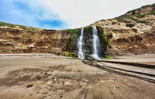
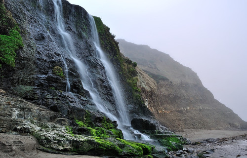
Alamere Falls
CCL: https://bit.ly/3hpOKfc
Alamere Falls Facts
- Last up among our choices for inclusion in this article about 5 Obscure United States Geological Gems, but by no means least, come the stunning Alamere Falls.
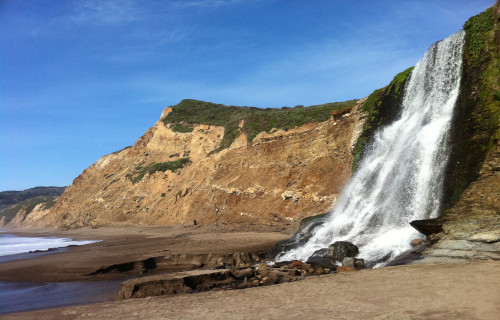
- The breathtaking work of geological forces known by nthe simple name stands out from the crowd. In point of fact, it represents not only a remarkably beautiful waterfall, but also a highly uncommon one. It also forms what’s known as a tidefall.
- The gorgeous site therefore stands out from other cascades, which only adds to its great allure. This truly remarkable and visually stunning fall forms one of only two such in the region. In fact, very few of this type exist anywhere on earth.
- Reaching the site, however, can be quite the arduous undertaking. It can also only be achieved by land via the Coast Trail. This awesome environmental project, created by the California Coastal Conservancy, in 2001, cuts through the region.
- Much of the terrain surrounding the incredible Alamere Falls, however, remains quite rugged in nature. Surprisingly, though, this fact does not deter the determined explorers and adventurers who frequent the beautiful region.
- In point of fact, the very rugged nature of the area serves to make the location a popular one for hikers. Extreme caution must be exercised, however, given the nature of the local geography, as well as conditions in the proximity of the waterfall.
CCL: https://bit.ly/3jW6lgB
Alamere Falls Physical Description
Apart from its great beauty, Alamere Falls also has a very unusual and distinctive formation. It constitutes what’s known as a tiered waterfall, but it’s not content to be a normal one. It actually consists of two relatively widely separated sections.
The first section also often goes overlooked by those not paying sufficient attention to its nature. The lower section receives most of the attention, yet the upper section remains the most complex in nature. But have no fear, for we will explain.
Location upstream from what’s considered the main Alamere Falls further sits the upper falls. This section actually consists of a total of three drops. Uniquely, each of these formed with roughly the same measurements, having a slight plunge equaling roughly 10 ft (3.1 m).
The separated lower section of this stunning formation, though, drops roughly 40 ft (12.2 m) by itself. This additional plunge provides the complete cascade with a total drop of about 70 ft (21.3 m). Though not large in height, it nonetheless creates a striking effect.
CCL: https://bit.ly/3hsLu2T
Alamere Falls Location, Nature, and Distinctiveness
The magnificent feature man calls simply Alamere Falls formed in a part of the world already well known for its many beautiful sites. That’s because the distinctive, and remarkable, waterfall formed in the state of California, in the United States.
More precisely, though, it lies within the confines of what now forms the Point Reyes National Seashore, in Marin County. The formation itself also forms a part of the similarly-named Alamere Creek, which winds tortuously through the surrounding area.
Yet none of these factors, in themselves, explains the full extent of the appeal of the geological marvel to those who encounter it. This, however, actually stems form the incredibly picturesque, not to mention unique, location of the final drop of the waterfall.
The water of the fall itself generally flows throughout the year, and in respectable abundance. At the culmination of that flow remains where the true appeal of it comes into play. The small cliff which it drops over actually hangs over a small beach.
Yet the truly marvelous nature of the amazing Alamere Falls is taken even one step further by the creation of Nature. During periods of high tide, the flow from the falls will drop directly into the ocean, making for a once-in-a-lifetime viewing opportunity.
CCL: https://bit.ly/31kFWh4
5 Obscure United States Geological Gems
We truly hope that you have thoroughly enjoyed reading this article about 5 Obscure Untied States Geological Gems. Its our futher fervent hope that doing so has engendered in you a greater knowledge of, and appreciation for, such natural wonders of our world.
Sadly, however, many of the magnificent features created by natural processes across the ages now face threats. The actions of man threaten many of them with alteration, or even outright destruction. We must do all we can to protect these natural marvels.
Check out our other articles on 5 Amazing Andean Species, Earth’s Many Magical Moths, 4 Fabulous Marine Shrimp, 6 Mysterious Natural Phenomena, The Mighty Tornado