


We sincerely hope that you thoroughly enjoy this article about these 6 Geological Marvels of Oregon. This part of the world just seems to teem with more than its fair share of incredible natural beauty, and that principle certainly extends to its geology.
Some of these locations remain better known than others, as you will discover as you read on. But each and every one of them is fully deserving of appreciation. We welcome the opportunity to perhaps introduce you to a few, for you, previously unknown wonders.
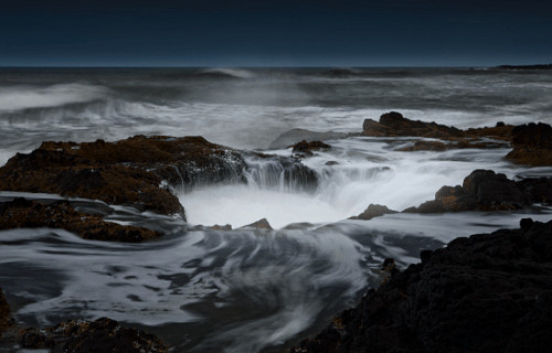
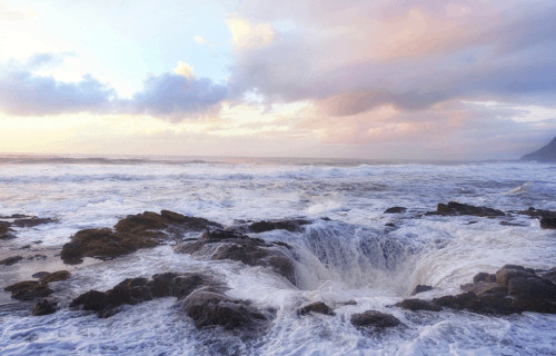
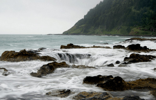
Thors Well

CCL: https://bit.ly/1xMszCg
Thors Well Facts
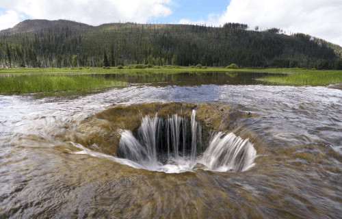
- Leading off this article about 6 Geological Marvels of Oregon comes the awe-inspiring site known as Thors Well.
- The absolutely breathtaking geological feature with the unique name forms an incredible sight to behold. Viewing it can present hazards if care is not taken, however. Local authorities, therefore, routinely issue advisories to those visiting the site.
- This wonder of Nature amply demonstrates the fact that the power of Nature must be respected. Rising tides and waves create a spectacular, but dangerous, effect. Water gets drawn in by a massive current, then spouted back out in a powerful fountain effect.
- Fortunately for us and our posterity, both the awesome Thors Well and the cape it sits in now form part of Siuslaw National Forest. This situation provides both the site itself, and those who visit it, with a certain measure of mutual protection.
- This geological marvel has been given many quite colorful common names since its discovery by relatively modern explorers. These alternate terms even include such colorfully descriptive names as the drainpipe of the Pacific.
CCL: https://bit.ly/1ryPA8o
Thors Well Physical Description
The stunning feature of the work of Nature men call Thors Well does not rely upon sheer size for its fame. This quite beautiful, though admittedly also quite dangerous, depression along the shoreline measures roughly 20 ft (6 m) deep, and about half that in width.
This stunning formation, which often leaves visitors nearly speechless, also bears a remarkably circular shape to its exterior. Although scientists believe they know the origin of the opening, they have no explanation for the nearly perfectly circular shape of it.
The remarkably and impressive opening of Thors Well connects directly to the nearby sea. This opening allows for the influx of water into and out of the hole, making for some truly spectacular fountains of water, especially at high tide or during the frequent storms.
CCL: https://bit.ly/1ryPA8o
Thors Well Location, Formation, and Hazards
The astonishing geological feature known as Thors Well formed in a part of the world already known for the beauty of its other geological marvels. This awesome structure formed at what man now calls Cape Perpetua, itself a particularly lovely headland.
More precisely, though, this fascinating, if potentially dangerous, wonder sits in the state of Oregon, in the United States of America, in North America. This naturally occurring depression also lies surrounded by a largely pristine section of old-growth forest.
Scientists have several theories about the formation of Thors Well. For the moment, the leading theory for the origins of this unique site propose that wave action first formed a small sea cave, only to have ongoing erosion later cause the roof to collapse inward.
The minor mystery, and major mystique and natural beauty of Thors Well serve to make it a popular tourist draw in the region. Quite unfortunately, many of those tourists approach the site without adequate knowledge of the potential dangers it frequently presents.
During low tide, the formation itself appears to simply be a large but otherwise unassuming depression along the shore. As the tide rises, however, this quickly changes. The rapidly and powerfully rising ocean currents create enormous pressures.
The water is drawn in and spouted out with great force, with the spume reaching great heights. The water then pulls back in with incredible force. Between the slippery conditions and the powerful flow of water, the conditions near Thor’s Well remain very hazardous.
Lost Lake
Lost Lake Facts
- Next up among our choices for inclusion in this compilation of 6 Geological Marvels of Oregon is the mysterious Lost Lake.
- The mysterious body of water perfectly represents a truly fascinating geological oddity. That holds true due to the fact that each year the entire lake disappears during the winter. Yet, this does not occur due to evaporation, as you might expect.
- An extraordinary event takes place in this location on an annual basis. Routinely, the entire volume of water in this quite lovely, but otherwise unassuming lake, vanishes. In its case, this water quite literally vanishes down a hole in the ground.
- Plus, its existence never formed a secret to the indigenous population inhabiting the region. Local Native Americans have long known of the uniqueness of the site. They called the lake Kwoneksamach. European Americans first discovered it in the 1870’s.
- In our current age, Lost Lake now plays an important role in the local region. That’s due partly to the fact that it remains quite popular with photographers. This incredible feature also now represents a highly popular camping site.
CCL: https://bit.ly/3ht30nF
Lost Lake Physical Description
While the presence of the remarkable vanishing water makes Lost Lake unique, it has much to offer even aside from this. For one, the lake itself has its own appeal. The location also ranks as the second-deepest lake in its particular portion of the country in which it formed.
The wonderful site has a marginally oval shape to it, being only slightly longer than it is wide. Firstly, the lake has a maximum measured length of roughly 5,395 ft (1,644 m). Secondly, the maximum measured width of the body of water equals about 4,150 ft (1,260 m).
Provided its length and width, the natural wonder has a respectable area of coverage. Its measurements give the gorgeous and surprising Lost Lake a surface area of roughly 245 acres (99.1 ha). It also boasts the impressive maximum measured depth of 167 ft (51 m).

Lost Lake Location, Formation, and Mystery
The small, but truly lovely Lost Lake lies in an intentionally undeveloped portion of its continent. It formed in Santiam Pass, Oregon, in the United States, in North America. The magnificent and mysterious body also forms part of the Mount Hood National Forest.
The truly awesome site itself further sits amid even more natural beauty, which only serves to augment its own. To begin with, to the east the wonder of nature remains bounded by the huge Lost lake Butte, which stands an impressive 4,468 ft (1,362 m) high.
But the awesomeness of its surroundings does not end there. To the southwest of the region lies the 4,556 ft (1,389 m) Preachers Peak. This fascinating development of Nature also receives its water from a total of three small but active creeks.
The most astounding feature of this extremely fascinating site, though, doubtless remains the mystery surrounding the vanishing water. That remains true due to the incredible fact that its outlet continues to remain a complete enigma to any who research it.
Amazingly, in fact, despite numerous studies and investigations, no outlet for the disappearing water has ever been found by anyone. Although research, study, and various explorations continue, this aspect of Lost Lake remains a complete puzzle.
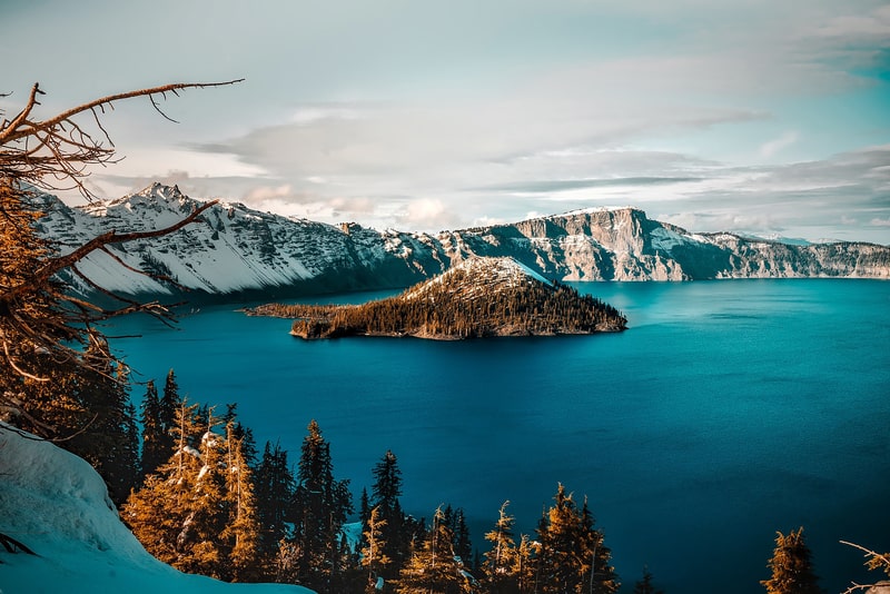
Crater Lake
Crater Lake Facts
- Placing third on this list of 6 Geological Marvels of Oregon, the stunning Crater Lake does so only due to random selection.
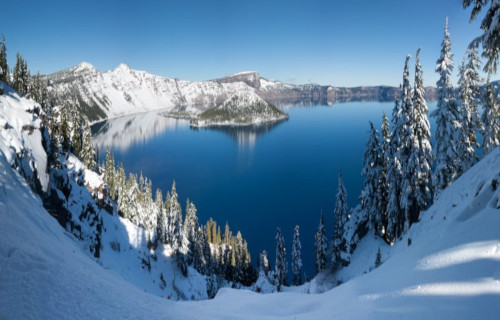
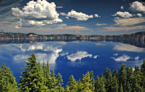
- Perhaps most notably, the mind-blowing site presently remains best known, and in fact quite famous for, two related things. These, quite understandably, consist of the gorgeous color and incredible clarity of the water within its boundaries.
- In fact, the magnificent lake routinely ranks in the top five among bodies of fresh water with the greatest clarity. The famous distinctive bluish hue of the waters occurs due to the combination of its great clarity and extreme depth.
- But the remarkable uniqueness of this marvel of Nature does not end there. This marvel of Nature also has two small islands within its confines. These two islands bear the names of Wizard Island and Phantom Ship.
- Native Americans knew of the gorgeous site now called Crater Lake for untold centuries prior to its discovery by European explorers. The first of these individuals or groups to report sighting of it was John Wesley Hillman, in 1853.
CCL: https://bit.ly/1p2b8Ke
Crater Lake Physical Description
Firstly, the incredibly stunning beauty of Crater Lake often overshadows the great volume of the site. The geological beauty quietly conceals a maximum measured water depth of an astounding 1,949 ft (594 m).
As a result, it ranks as the deepest lake in its country, and ninth in the entire world. But it isn’t just deep, to be certain. It also has a large overall area. The lake has a slightly rectangular shape, measuring 5 mi by 6 mi (8 by 9.6 km).
It also remains unusual for another reason. It has no bodies of water flowing into it. In a natural balance, evaporation is roughly compensated for by rainfall and melting snow. This makes it one of the few such lakes on earth.
The two small islands within the gorgeous Crater Lake further have distinctly different natures. Wizard Island is a cinder cone, roughly 316 acres (128 ha) in area. Phantom Ship, meanwhile, is a naturally formed pillar of rock.
CCL: https://bit.ly/1jxQJMa
Crater lake Location, Geology, and Climate
The awesome Crater Lake formed in what now is the state of Oregon, in the United States, in North America. This wonder of Nature now forms the principal feature in Crater Lake National Park, in the south-central part of the state.
This amazing lake sits in the caldera of an extinct volcano, named Mount Mazama. This volcano erupted quite violently roughly 7,700 years ago. Part of the Cascade Range, this volcano has now been quiet for about 6,000 years.
However, minimal amounts of geothermal activity still routinely appear along the floor of the breathtaking Crater Lake. This further indicates that, although considered unlikely, it has the potential to one day erupt again.
Finally, the region has a subalpine climate. As a a result of its great elevation and the influence of the North Pacific High, it has a very rare dry-summer climate. Summers therefore tend to be dry and mild, but winters are cold, with enormous snowfall amounts.
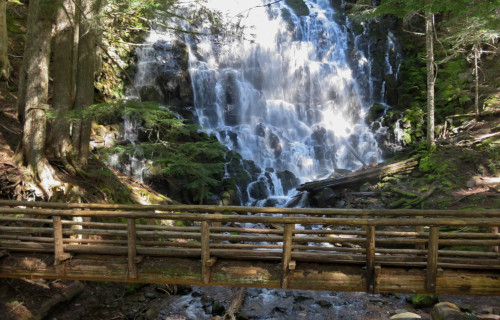
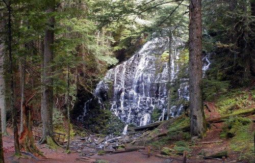
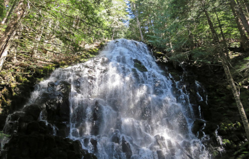
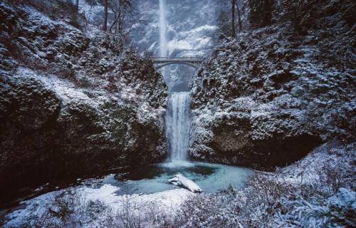
Ramona Falls
CCL: https://bit.ly/3g1LrqZ
Ramona Falls Facts
- The location appearing next within this compendium of 6 Geological Marvels of Oregon is the magnificent Ramona Falls.
- The breathtaking geological formation known by the simple name remains one of the most beautiful cascades known to man. Part of its extreme beauty comes from the fact that it also has one of the most distinctive appearances of any such formation.
- To many people, this marvel of Nature looks like someone blended a waterfall with the inside of a beehive. Not so coincidentally, the type of remarkable rock formation over which it flows many people know as a honeycomb structure.
- The first reported sighting of this stunningly beautiful waterfall in modern times, amazingly, did not occur until 1933. At that time, a Forest Service employee named John E. Mills came across it and named it. He did this while creating a trail.
- The incredible flow of water that he named Ramona Falls had, however, long been known by local populations of Native Americans. Today, the area may only be accessed via a hike along a rugged trail. This helps account for its being little known.
- Yet, the region in which the wonder of geology lies now forms part of the magnificent Pacific Coast Trail. In fact, the spot also represents the junction of two extremely popular hiking trails. These bear the names the Timberline and the Ramona Falls Trail.
CCL: https://bit.ly/2Vo739a
Ramona Falls Physical Description
The truly breathtaking cascade referred to simply as the Ramon Falls never fails to dazzle those who see it. It does not do so due to seer physical size, though. That’s because this wonder of Nature has a total height that measures approximately 120 ft (37 m).
Yet this frequently overlooked, but nonetheless awesome fall also possesses other, highly respectable, and to some, surprising, statistics. Among these remains the fact that the gorgeous flow of water sits at an elevation that measures 3,560 ft (1,090 m) above sea level.
The staggering beauty of Ramona Falls derives from not simply its height. This only ranks as average, but it has remarkable structure. It’s composition of a series of interlocking, hexagonal-shaped columns creates a multi-layered visual effect that leaves one breathless.
CCL: https://bit.ly/2YC51UR
Ramona Falls Location, Formation, and Nature
The awe-inspiring work of Nature named Ramona Falls formed in a truly picturesque, and somewhat out of the way, part of the world. This geological gem formed on the western side of what’s now known as Mount Hood, in the state of Oregon, in the United States.
More precisely, however, this beautiful cascade also finds itself in an area already so admired for its beauty that it’s garnered federal attention. The waterfall sits within the boundaries of the Mount Hood National Forest, though it remains little known to tourists.
A large component of the great beauty of the site remains the distinctive nature of the rocks over which the water flows. These formed as the result of an ancient volcanic flow, although even volcanologists differ as to exactly when in the past this action occurred.
At the time of the eruption, the flowing lava, largely basaltic in nature, slowly cooled. As it did so, it formed countless vertical hexagonal columns. Erosion later created the distinctive honeycomb pattern, over which the water flows with such beauty now.
The flow of water for the fabulous Ramona Falls itself originates from nearby Mount Hood, although rainfall obviously adds to this flow at times, and in varying amounts. There, the steady process of glacial melt provides a steady stream for a moderate flow.
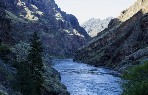
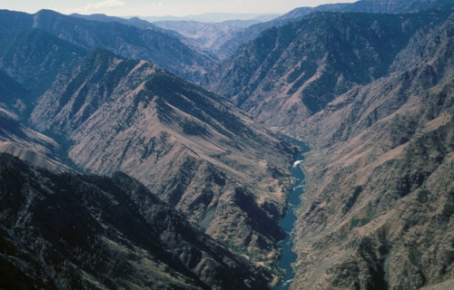
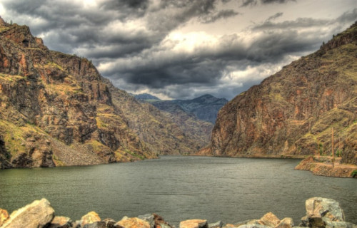
Hells Canyon
Public Domain Image
Hells Canyon Facts
- The fifth of our selection for inclusion among these 6 Geological Marvels of Oregon is the dazzling wonder known as Hells Canyon.
- Very notably, the breathtaking canyon remains one of the great marvels of its region. Quite surprisingly, to most of the world outside of its region, this wonder remains virtually unknown.
- It unfortunately remains in the shadow of that well-known marvel, the Grand Canyon. This amazing site surpasses it in depth, however. In fact, this ranks as the deepest canyon on its continent.
- It remained unknown to European settlers until 1806. At that time, members of the Lewis and Clark Expedition found the site. They turned back before exploring its entirety, though, for unknown reasons.
- But, the magnificent gorge had long been known to local Native Americans. Several different tribes used the canyon, in fact. These included the Nez Perce, Shoshone-Bannock, and the Paiute.
- Finally, today it serves as a locally very popular recreational area. Yet, most of it remains inaccessible by road. It currently serves as a major component of the Hells Canyon National Recreational Area.
Public Domain Image
Hells Canyon Physical Description
First of all, the sheer grandeur of the mesmerizing Hells Canyon must be taken into account. That’s because it’s sheer dimensions only tell part of its story. Those nevertheless remain impressive enough on their own.
Firstly, the magical geological wonder has a truly astounding overall width. That holds true because that measures roughly 10 mi (16 km). Secondly, its maximum depth measures an astounding 7,993 ft (2,436 m). It also has a total length of about 125 mi (200 km).
The beautiful Snake River also flows through the fabulous canyon. Yet, at one point it does so at more than 1 mi (1.6 km) below the western edge. On the other side, majestic mountains further soar to a height of 7,400 ft (2,300 m) above it.
The awesome Hells Canyon additionally serves as home to an abundance of wildlife. This includes large numbers of black bears, elk, cougar, mountain goats, and deer. Several plant species actually thrive there that exist nowhere else, as well.
Public Domain Image
Hells Canyon Location, Formation, and Usage
The sincerely stunning Hells Canyon formed in what now comprises the far northwest section of the United States. This enormous canyon also remains one of the great geological wonders of North America.
It is located roughly along the borders of three states. These consist of Idaho, Oregon, and Washington. Its earliest formation began around 300 million years ago. This began as the result volcanic activity, not tectonic.
Not only that, but due to the ongoing volcanic action, enormous quantities of limestone began to be deposited. Much later, tectonic activity then pushed the limestone, along with sedimentary rock, upward.
About 6 million years ago, though, the Snake River formed within what’s now Hells Canyon. Its mighty flow slowly but surely carved out the massive canyon. Then, roughly 15,000 years ago, a massive flood from a melting glacier further expanded it.
Lastly, today the site has several primary uses for mankind. First of all, three large hydroelectric dams have been constructed within its confines. Also, recreational activities happen in abundance within it. These include hiking, boating, fishing, camping, and rafting.
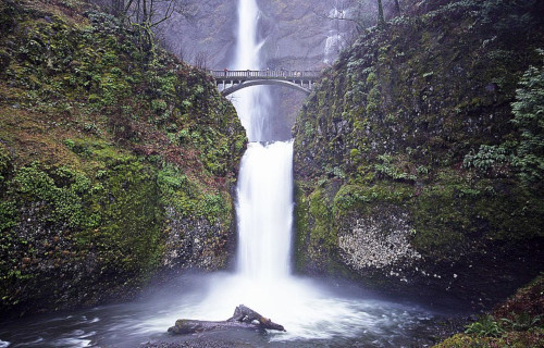
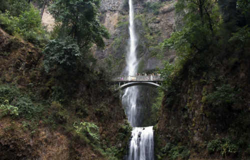
Multnomah Falls
CCL: https://bit.ly/1E6HPMf
Multnomah Falls Facts
- The final location appearing on this listing of 6 Geological marvels of Oregon is the breathtaking site man calls Multnomah Falls.
- The serenely breathtaking waterfall remains another of those stunning natural features that few people outside of its region known about. However, in that region, the cascade nonetheless forms one of the most often visited tourist sites.
- In order to facilitate the enormous volume of foot traffic, observation decks have been constructed in several locations around the feature. Thus, with the much greater ease of access, more than two million people visit the wonder of Nature each year.
- Evidence indicates that local Native American tribes knew of the site for centuries prior to the arrival of outside explorers. The Lewis and Clark expedition, in 1805, became the first known non-indigenous individuals to discover the gorgeous site.
- The magnificent Multnomah Falls itself derives its distinctive name from one local group, named the Multnomah. The beautiful location also holds great significance to the members of the tribe, including forming part of their tribal mythology.
CCL: https://bit.ly/1eBd9Ks
Multnomah Falls Physical Description
Perhaps surprisingly to some, the magnificent Multnomah Falls ranks as the tallest waterfall in its area. The awesome cascade, comprising a two-tier fall, has an overall height measuring roughly 620 ft. The upper section of the cascade comprises the majority of that, though.
In all its visual splendor, that upper section measures a total of about 542 ft (165 m) in height. The lower section, however, regardless of its visual appeal, only measures a total of 69 ft (21 m). A small decline equaling roughly 9 ft (3 m) also separates the two sections.
Despite its great height, the feature has a comparatively narrow width. In fact, this dimension of Multnomah Falls averages on 10 ft (3.05 m) throughout most of the year. Finally, these factors combine to provide it with an average flow rate of 150 cu ft/s (4.2 m3/s).
Multnomah Falls Location, History, and Formation
The supremely awe-inspiring geological feature known as Multnomah Falls formed in what now constitutes the state of Oregon, in the United States, in North America. Presently, visitors to the area can access the natural wonder via the Historic Columbia River Highway.
Numerous pieces of geological evidence also indicate that this marvelous cascade originally formed about 15,000 years ago. This fortuitous formation occurred as a result of the gargantuan period of activity known as the Missoula Floods, at the end of the last ice age.
But, separating Multnomah Falls from the majority of other waterfalls is the primary source of its water. Unlike most similar features, it doesn’t have runoff or rain as its major source. Although these do add to the flow, most of its water originates in underground springs.
CCL: https://bit.ly/1xMszCg
6 Geological Marvels of Oregon
We truly hope that you have greatly enjoyed reading this article about 6 Geological Marvels of Oregon. We also further hope that some of you may have discovered either places previously unknown to you, or, at least, some new wonderful facts about a place you already knew.
Sadly, though, some of these 6 Geological Marvels of Oregon will need our help in the future, to maintain them in their pristine conditions. In some areas, the encroachment of civilization threatens to destroy the ecosystems, which could disrupt these wonders.
Check out our other articles on 8 Incredible Asian Mammals, Earth’s Many Magnificent Marsupials, 7 Bizarre Ocean Invertebrates, 7 Lesser-Known South American Mammals