


It’s our hope that each of you, our readers, will enjoy and appreciate this article we present about these 7 Breathtaking East Coast Wonders. It was certainly our pleasure to gather the information for you. May it provide you with both education and increased awareness.
Certainly, these formations listed herein represent only a portion of the marvels found throughout this amazing region. It’s our belief, though, that they serve as excellent representations of the features found here. Check out some of our other articles, as well.
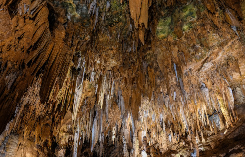
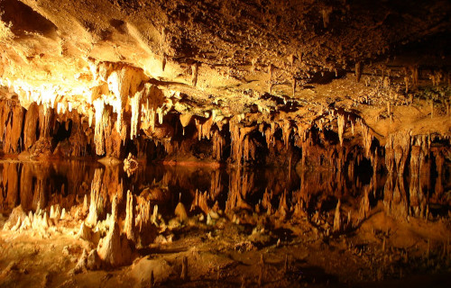
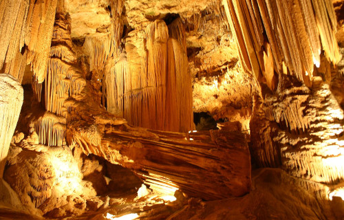
Luray Caverns
CCL: https://bit.ly/3GRja5g
Luray Caverns Facts
- Leading off this article about these 7 Breathtaking East Coast Wonders we present the subterranean beauty that is Luray Caverns.
- This spectacular, though lesser-known, marvel of geology most frequently goes by the deceptively simple name used herein. It did possess a slightly different name in the past, though. This magnificent site originially bore the name of Luray Cave.
- Not surprisingly, local Native American populations long knew of the existence of this fabulous formation. There’s no evidence of regular use or visitation by them, though. Exactly how long ago they discovered it also continues to remain unknown.
- In modern times, however, the first known sighting of the caverns by non-native settlers occurred on August 13, 1878. At that time, five locals stumbled upon the natural wonder. Their attention had been drawn by an air current from a small sinkhole.
- Legal disputes over ownership of the property on which the system lies quickly came into play, however. That occured because the men who discovered the site did not disclose it to the then owners, because the land was due to be sold at auction.
- Following this realization, legal battles began. The courts eventually nullified the first purchase of the land. Later, the overall tract of land changed hands several times in the next few years. Eventually, the Luracy Caverns Company purchased the site in 1893.
- Its stunning visual scenery understandly quickly drew massive attention to what later became known as Luray Caverns. The government officially listed the location as a National Natural Landmark in 1974. As of 2018, about 500,000 people visit it per year.
CCL: https://bit.ly/3Ms7t6o
Luray Caverns Physical Description
Luray Caverns represents a series of interconnected caverns. Each impresses the fortunate visitor with its abundance of wonders. Though it’s certainly not the most extensive such system known, it packs a real punch. Its physical description nevertheless bears mentioning.
The entrance from the surface begins as a path that angles downward. This quickly opens into the interconnected series of chambers of various dimensions. The smallest of these has a ceiling of about 30 ft (9 m). The highest, though, reaches an impressive 143 ft (90 m).
It’s not just about the pure size of the location, though. It’s also about the splendor to be observed there. This site boasts an extraordinary array of natural formations. For starters, it possesses a wide array of features such as stalactites, stalagmites, and mud flows.
This splendor’s also augmented by the presence of two bodies of water. These features bear the literary names of Dream Lake and the Silver Sea. The former remains the largest body of water present. Despite a naturally created illusion, it’s only around 20 in (50 cm) deep.
The most astonishing feature of the Luray Caverns, however, remains one named the Luray Singing Tower. That’s a remarkable assemblage of stalactites formed in close proximity. A total of 47 of them, in fact. This collection measures an incredible 117 ft (36 m) in height.
Colors of the various formations vary, of course. Surprisingly for many, though, white predominates. Incredibly, this memorable site packs all these wonders into a comparatively short length. That’s because the entirety of the structure only extends for 1.5 mi (2.4 km).
CCL: https://bit.ly/3Ms7t6o
Luray Caverns Location, Formation, and Illusions
The Luray Caverns formed in a region of the world already well known for its abundance of natural beauty. That’s due to the fact that this natural wonder formed in what now constitutes the continent of North America. Even here, it stands out from similar features.
Within this larger area, it lies within the confines of the United States. There, it further sits on the eastern side of the continent. Natural processes additionally created it in the region now called the state of Virginia. It’s situated close to the far northern border of the state.
The precise date of formation for this marvelous site also presently remains undetermined. The closest geologists can come is that its origins lie sometime during the Tertiary Period. That, though, places its beginnings anywhere between 66 and 2.6 million years ago.
The exact process that began its formation also remains definitively undetermined. The most likely cause, however, continues to be simple erosion of the surrounding rock strata by the actions of water. That’s composed primarily of a relatively soft stone known as dolomite.
Luray Caverns also boast two separate illusions within its walls. At Dream Lake, its water remains so still that stalactites hung from the ceiling are reflected in the water. This creates the illusion that they’re actually stalagmites. But the water’s only about 20 in (50 cm) deep.
A small greenish pond within the caverns creates the opposite illusion. Named the Wishing Well, this gives the appearance of being roughl 3 – 4 ft (0.91 – 1.22 m) in depth. Despite this, the small body of water actually measures 6 – 7 ft (1.8 – 2.1 m) in average depth.
Flume Gorge
CCL: https://bit.ly/3tyu8HW
Flume Gorge Facts
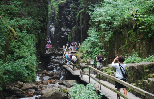
- Next up in this compendium of 7 Breathtaking East Coast Wonders we present the stuning beauty known as Flume Gorge.
- The somewhat understated term it goes by serves as the name of a stunning, lesser-known natural geological formation. While not widely known outside of its immediate area, it nonetheless fully deserves its own degree of merit and appreciation.
- It’s currently not officially known if the local Native American population knew of its existence in past ages. That’s only due to a lack of formal information on the subject. Given their long-term presence in the area, though, it seems likely they knew of it.
- The first recorded discovery of the site by a non-native, however, took place in 1808. That’s because, at that time, an elderly, local resident settler came upon it accidentally, while fishing. The intrepid 93-year-old was known as “Aunt” Jess Guernsey.
- In modern times, the remarkable Flume Gorge understandably became a popular recreational destination among locals. Subsequently, the gorgeous location became part of a small protected site. That’s the lovely Franconia Notch State Park.
- Due to this, it’s now only viewable by paid visitors to the site. This allows for a modicum of protection for the feature, from the depredations of unattended visitors. Concerted efforts also remain underway to preserve the gorge in its pristine condition.
CCL: https://bit.ly/3qp4B1R
Flume Gorge Physical Description
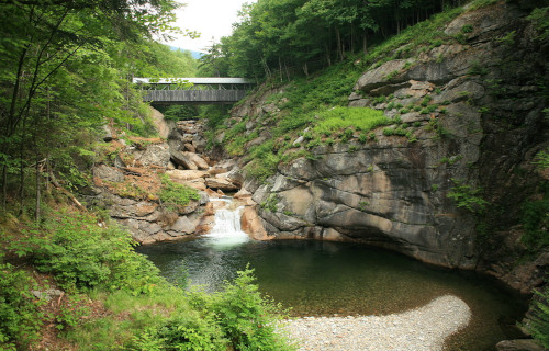
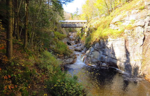
The magnificent formation known simply as Flume Gorge perfectly proves a well-known observation about Nature. That’s the belief by some that natural forces place no importance on relative size when it comes to the amount of beauty imbued within them.
That statement’s true since this naturally formed canyon actually remains rather small, compared to many such features around the world. But it packs a lot into that small space. Indeed, its confines also contain several smaller features, themselves worthy of some note.
This natural small canyon extends comparatively straight for approximately 800 ft (240 m). Given its short length, its walls further rise to relatively great heights. This measurement varies along its length, however. These range in height from roughly 70 – 90 ft (21 – 27 m).
Breathtaking Flume Gorge isn’t for those few visitors who suffer from claustrophobia, though. That’s because it’s also quite narrow, considering its length. Across the totality of its length, the distance between the sides only ranges from about 12 – 20 ft (3.7 – 6.1 m)!
The location also boasts its own stunning, if small, waterfall. Appropriately named Avalanche Falls, this formed in recent times. That formation occurred due to the actions of a powerful storm in 1883. The cascade plunges 45 ft (13.6 m) at the entrance to the gorge.
CCL: https://bit.ly/3isA8eH
Flume Gorge Location, Formation, and Ecology
Flume Gorge formed in a portion of the world known for its abundance on natural beauty. That’s due to the fact that it lies in a portion of the continent of North America. Though the region’s better known for its botanical beauty, it also hoasts geological ones as well.
More precisely, however, the wondrous site lies within the confines of the United States. There, its formation placed it in the far northeastern portion of the country. This geological masterpiece further sits near the base of Mount Liberty, in the state of New Hampshire.
It’s also surprisingly old. The origins of this work of geological forces reach all the way back roughly 200 million years. The specific rock of the region, known as Conway granite, began as deeply buried molten rock. This also broke into vertical fractures as it cooled.
Other forces of Nature subsequently acted to contribute to its formation. Erosion expanded the fractures, widening them. This led to water being allowed in, which further expanded the structure. Eventually, it reached the general dimensions it possesses at this time.
Due to its nature, few species make their home within the confines of Flume Gorge. Yet life always clings wherever it can. A scattering of trees managed to gain a foothold in cracks along the steep walls of the canyon. Moss and ferns also appear in scattered locations.
Because of the presence of the trees and ferns, a variety of locally prevalent insect species naturally appear as well. Various varieties of birds also make their homes in the branches of the trees. A handful of aquatic invertebrates and fish also live in the gently flowing stream.
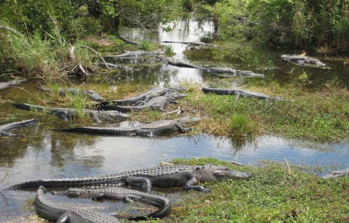
Everglades
CCL: https://bit.ly/35Fxz1L
Everglades Facts
- Here in this gathering of these 7 Breathtaking East Coast Wonders we give you the extraordinary locations known as the Everglades.
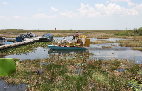
- The surprisingly simple term serves as the name of an astounding natural ecosystem unlike any other currently existing on the planet. This incredible formation actually represents a unique area of naturally occurring tropical wetlands.
- The first written mention of this marvelous work of Nature occurred on the maps on early Spanish explorers. However, those who composed the maps had not actually seen the site, but relied on reports of the local indigenous populations.
- Those same Native American populations, though, had long known of its existence. In fact, evidence indicates that the region has been inhabited for more than 15,000 years. Various tribes lived there, including the Calusa and Tequesta.
- Regrettably, as modern man encroached on the region, large sections of the site were drained. Beginning in 1882, numerous projects undertook this modification in an effort to create large sections of both farmland and urban areas.
- Quite thankfully, in modern times, the remarkable Everglades now enjoys a certain amount of legal protection. Both the Ramsar Convention and UNESCO currently designate this fantastic area as a Wetland Area of Global Importance.
Everglades Physical Description
The precise dimensions and area of the Everglades remains, quite literally somewhat fluid. This occurs as a wholly natural result of its very nature, though. Nevertheless, the region officially considered to comprise it covers an area of roughly 1.5 million acres (607,028 ha).
It also comprises a component of a large drainage basin, which accounts for its prodigious quantities of moisture. The formation further actually represents a very slow-moving body of water, though some pockets remain stationary for extended periods of time.
Although several large ecosystems exist in the Everglades, the single greatest one remains composed of areas of sawgrass marsh. Unlike any other wetland on the planet, this region maintains itself primarily through the regular, frequently heavy, rainfall amounts.
Everglades Location, Climate, and Ecosystems
The dazzling and wholly unique marvel of Nature that man now calls the Everglades formed in a part of the world that may surprise some people. That’s due to the fact that, though it has a tropical climate itself, the surrounding area remains a temperate zone.
In point of fact, this wonder formed in a small corner of the continent of North America. That exact location often amazes those who first learn of the remarkable site. More precisely, however, it lies in the southern portion of the state of Florida, in the United States.
The state itself lies almost directly across the dividing line between tropical and subtropical zones. The Everglades lie in the southern portion of that, which provides it with its tropical type climate. The majority of its rainfall occurs in the wet season, from May to October.
Others are present, but the great majority of the Everglades is composed of three separate ecosystems. The line of demarcation, though, also remains quite blurred. Sawgrass represents the single largest of these, and remains perhaps its best known feature.
Another of these is formed by large areas of sloughs. These are large, freely flowing channels of water wending through the sawgrass. While their width understandably varies, these typically maintain a depth about 3 ft (0.9 m) greater than that of the sawgrass.
The formation known as wet prairies rounds out the three. They also tend to serve as border areas between the other two ecosystems. These have the greatest diversity of flora, and the covering layer of water only averages about 4 in (10 cm) in overall depth.
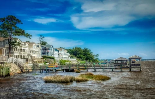
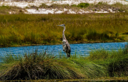
Outer Banks
Outer Banks Facts
- The next feature chosen for inclusion in this listing of these 7 Breathtaking East Coast Wonders is the mesmeric beauty named the Outer Banks.
- Perhaps most notably, the somewhat unique term serves as the name for a particularly visually stunning collective geological feature. Furthermore, this particular example of this type of formation has an incredibly beautiful composition.
- The remarkable site actually consists of an entire chain of what’s commonly known as barrier islands, as well as numerous large sandbars. Not surprisingly, of course, the local Native American tribes clearly knew of this fabulous site for countless centuries.
- This region remained unknown to the rest of the world until late in the 16th century, however. At that time, though, British sailor Richard Grenville, established the ill-fated settlement, now known as the Lost Colony, on one of the islands, in 1585.
- Subsequently, on June 22, 1587, John White, who had accompanied Richard Grenville on that first voyage, returned. During this period, along with 116 English settlers, he established the first successful European colony in this part of North America.
- Among other things, therefore, the Outer Banks played a key role in the history of this part of the world. Yet, that’s not its only claim to historical fame. Its unique location and resulting weather patterns have been put to good use.
- This holds true due to the fact that the Wright Brothers chose a location there for the first powered flight in recorded history. The choice occurred because of certain naturally occurring characteristics of the remarkable location aided in their efforts.
- Today, the Outer Banks remains of vital importance. Firstly, numerous national landmarks fill the area. Secondly, the region also contains many protected areas, due to its ecosystems. Thirdly, its great beauty makes it a popular tourist destination.
CCL: https://bit.ly/2yyyHbD
Outer Banks Physical Description
To begin with, it must be pointed out that the incredible location known as the Outer Banks includes more than just one feature. In point of fact, this dazzling wonder of Nature contains a total of 8 islands and peninsulas, along with numerous sandbars.
The islands bear the names of Corolla, Duck, Kitty Hawk, Kill Devil Hills, Nags Head, Roanoke Island, Hatteras Island, and Ocracoke Island. These principal islands, however, along with the various sandbars, stretch out over a distance of roughly 200 mi (320 km).
This forms a roughly arch-shaped structure, lying offshore of the continent itself. But the precise nature of the chain constantly changes in minor ways. Many of the smaller features, such as the sandbars frequently change, due to the influence of strong storms in the region.
The vast majority of the truly visually stunning landscape of the Outer Banks further remains quite flat in nature. The exceptions to this principle, though few, generally come in the form of sand dunes, some of which can reach 100 ft (30.5 m) in height.
Many of the fabulous islands also possess numerous beautiful beaches. These sometimes have relatively expansive dimensions. Some of the islands also possess a highly elongated shape, in some places being no more than 1 mi (1.6 km) in width.

Outer Banks Location and Wildlife
First of all, the magnificent work of Nature named the Outer Banks formed in the Northern Hemisphere, along the edge of a specific portion of the east coast of North America. More specifically, this area forms the eastern coast of the country of the United States.
Within that range, the majority of this feature extends along the shoreline of the state of North Carolina. A tiny portion of this geological wonder nevertheless extends northward, along the shore of the state of Virginia. But, that forms only the leading edge of it.
The Outer Banks serve as home to a rich and diverse ecological system. As a result of its unique climate and positioning, many species call it home. This includes a variety of seabirds. Many varieties of mammals also appear here, having arrived from the mainland.
Also, many forms of vegetation flourish here, as well. This includes such varied species as beach grasses and various trees, such as palms, as well as Spanish Moss. However, its most noted wildlife consists of a sizable herd of wild horses, living on the island of Corolla.

Outer Banks Climate
Because of its unique positioning, the stunning Outer Banks, along with its other marvels, enjoys a most remarkable climate. In point of fact, despite being less than 30 mi (48 km) offshore in most places, it has a decidedly humid subtropical climate.
Even the temperature of the ocean tends to be warmer than that along the continental shore. Specifically, this means that wintertime temperatures rarely reach the freezing point, in any part of its area. Also, the winds help to moderate the effects of summer temperatures.
Generally, though, the winter and fall periods remain somewhat warmer than inland areas. Meanwhile, spring and summer tend to be milder, thanks to nearly constant sea winds. Sadly, however, its location also makes the region prone to hurricanes.
In fact, regardless of its otherwise excellent conditions, it remains the most hurricane prone region north of the state of Florida. Finally, although snow in winter does happen, the average yearly total amounts to less than 3 in (7.6 cm) in even the most northern sections.
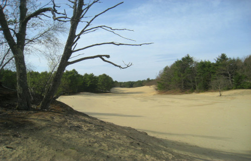
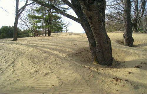
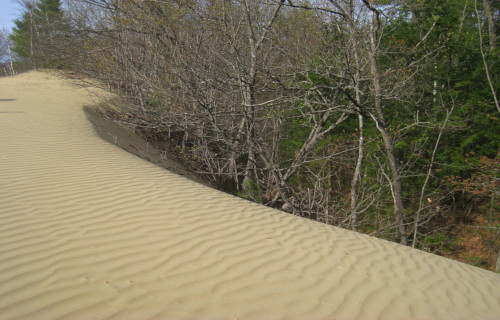
Maine Desert
Public Domain Image
Maine Desert Facts
- The fourth entry into this compilation of 7 Breathtaking East Coast Wonders bears the descriptive name of the Maine Desert.
- The remarkable location sometimes known by this simple term remains an incredibly unexpected feature within its region. This astonishing marvel of the work of Nature also goes by the similarly descriptive common name of the Desert of Maine.
- Regardless of the name one uses, however, one indisputable fact about this site clearly stands out. That’s the fact that this location actually forms a surprising geological phenomenon. Thus, it shows that names can sometimes be quite deceptive.
- That holds true due to the fact that, in the minds and opinions of some individuals, this site does not qualify as a true desert. That perspective occurs because the surrounding climate remains much too wet and cold to meet some definitions.
- The formation of this truly astounding feature, furthermore, did not come about naturally. In point of fact, this quite dry, arid region, whether it constitutes an actual desert or not, actually owes its existence to human activity. That alone sets it apart.
- Nonetheless, the surprising knowledge of its origins does nothing to detract from its fascinating nature. Quite understandably, the very uniqueness of the Maine Desert serves to garner the formation with a more than modest claim to fame.
- This surprising statement holds true due to yet another fascinating statistic. That’s the fact the location has been preserved as a natural oddity. That’s additionally been the case since 1925. A small museum and gift shop also presently exist on the property.
Public Domain Image
Maine Desert Physical Description
For all the controversy surrounding the Maine Desert, several key facts stand out when one considers it. Firstly, regardless of its origins, it covers a tiny area. Secondly, however, a debate over whether or not it’s actually a desert remains ongoing among concerned scientists.
As a result of this continuing situation, the formation does not officially hold the title of the smallest desert on earth. In fact, for the present moment, at least, the somewhat larger Carcoss Desert, in Canada, also finds itself in the very same predicament.
But, regardless of any official status, the site constitutes an interesting phenomenon. In terms of size, though, the Maine Desert only covers approximately 40 acres (16.2 ha). In this, it aptly demonstrates the fact that size has no bearing on impressiveness.
No matter its official situation, the remarkable feature definitely qualifies as unique, at the very least. That’s due not only to its origins, but also to its very nature. This occurs because it does not, in fact, consist of sand. It’s actually composed of glacial silt.
Public Domain Image
Maine Desert History and Formation
While it formed only recently, the beginnings of the story of the Maine Desert begins roughly 10,000 years ago. At the end of the last ice age, the glaciers retreated. As they did so, the foundations for the future formation of this fascinating site actually began.
The actual site of this beginning presently represents the state of Maine, in the United States, in North America. During the course of the slow but inexorable retreat of these glaciers, the withdrawing ice sheet went to work creating the masterpiece.
As a result of that movement, the ice ground rocks into a fine powder, known as glacial silt. Over the passage of millennia, copious quantities of topsoil became deposited over this. This finished condition remained comparatively stable for many thousands of years.
Then came huge numbers of European settlers. Eventually, a local family established a farm on this site. This occurred in 1797. Yet the people failed to manage the land properly. Poor farming practices also combined with overgrazing to erode the topsoil.
One day, a small patch of the underlying sand appeared. Furthermore, this formation quickly spread, eventually taking over the entire farm. Subsequent to this development, the Maine Desert was born. To date, it’s depth has never been measured.
Eventually, bowing to the inevitable, the family abandoned the farm in 1919. A man named Henry Goldrup purchased the property in 1925. Recognizing its uniqueness, he opened the site as a tourist attraction. Today, nature appears to be slowly reclaiming the area.
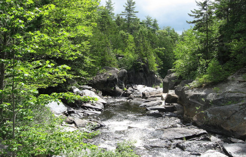
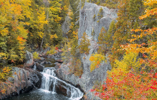
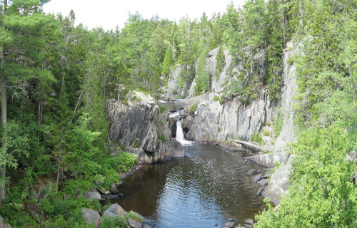
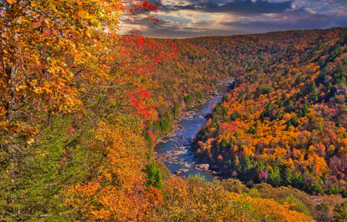
Gulf Hagas
CCL: https://bit.ly/3xfSrua
Gulf Hagas Facts
- Now making its appearance in this article about 7 Breathtaking East Coast Wonders we present you with the geological beauty named Gulf Hagas.
- This remote, ruggedly beautiful, yet little-known, marvel of geological processes bears the somewhat deceptive name given here. It’s quite obviously not a gulf, but is in fact a magnificent gorge cut through the surrounding terrain over a vast span of time.
- It’s not known when the first European settler in the region discovered this amazing site. The local Native American tribes, however, long knew of its existence. That’s because archaeological evidence of their presence dates back as much as 7,500 years.
- In modern times, though, the location constitutes one of 14 National Natural Landmarks in the region in which it formed. It thus represents a popular, if difficult to access, tourist area. It’s open to the public, for a fee, during the regular season.
- It also forms part of the incredible Appalachian Trail, which extends a total of 2,200 mi (3,500 km). In point of fact, the section in which it lies forms the last 100 mi (160 km) of the magnificent trail. It’s also considered by many to be the most remote portion.
- The opportunities for hiking therefore obviously form a primary appeal to visitors to Gulf Hagas. Its pure scenic beauty, however, also attracts many viewers. Other popular attractions to the site include kayaking its waters, though only for experts, and fishing.
CCL: https://bit.ly/3CO5rIG
Gulf Hagas Physical Description
The stunning Gulf Hagas quickly earns the appreciation of those fortunate enough to visit its location. That holds true due to numerous attributes, of course. Though it’s by no means the largest such feature on earth, it nonetheless boasts some respectable dimensions.
The beautiful gorge possesses a total length measuring approximately 3 mi (4.8 km). Much of that, though, holds a twisting, winding nature. While its walls naturally vary in height across its length, these reach a maximum height of 130 ft (40 m) in some locations.
A branch of the Pleasant River also flows through its length. Between it sheer vertical walls, the course of the river flows over a highly rocky bed. Numerous regions of rapids also appear along its length. Numerous small but lovely waterfalls also dot its course.
Along its length, though, the river also drops relatively significantly. More precisely, its elevation drops a total of 370 ft (110 m). Due to this comparatively steep decline, the flow becomes quite strong in some regions, creating the powerful rapids for which its known.
The width of the remarkable Gulf Hagas also, quite naturally, varies along its entire length. This variation becomes extreme in some places. In some sections, it attains a width of as much as 150 ft (45.7 m). In others, however, it narrows to as little as 26 ft (7.9 m).
CCL: https://bit.ly/3nH4vBK
Gulf Hagas Location, Formation, and Ecology
The astonishing beauty of Gulf Hagas formed in a region of the globe already well known for its abundance of geological marvels. That’s because this visually tantalizing work of Nature formed on the region that now constitutes the continent of North America.
More precisely, though, the gorge formed in the region that now comprises the state of Maine, in the United States. There, it further, and purely by coincidence, lies in the approximate middle of the state. It also lies about 90 mi (140 km) from the city of Bangor.
The section of the Appalachian Trail this wonder lies in also happens to bear the name of the Hundred-Mile Wilderness. It formed 400 million years ago. That occurred due to the convergence of tectonic plates. It’s part of what geologits call the Carrabassett formation.
Mud deposits slowly crystallized into the mineral slate. This now comprises the majority of the bedrock in its region. This mineral created angular edges when fractured, but wind erosion later smoothed these out. This further shows in the nature of the canyon walls.
Flora and fauna both abound within the confines of Gulf Hagas. In fact, its course wends its way through one of the last remaining virgin old growth forests in the region. Enormous eastern white pines line its course, some reaching as much as 150 ft (46 m) in height.
Many animal and insect species makes their homes within these forests, among the accompanying spruce and fir trees. Along with the usual small animals native to the region, such as the snowshoe hare, larger mammals such as various deer and elk also call it home.
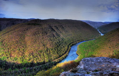
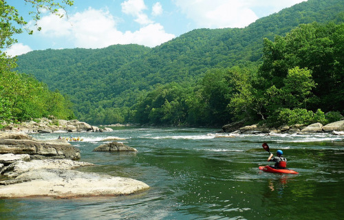
New River
CCL: https://bit.ly/2PiG13j
New River Facts
- Closing out this collection of 7 Breathtaking East Coast Wonders comes the winding body of water called the New River.
- This wonder of Nature, given this moniker, actually bears a potentially deceptive name. That’s due to the presence of a certain amount of controversy surrounding its exact age. Some, but not all, geologists consider it one of the oldest rivers on earth.
- Regardless of its status in that regard, however, this amazing work of geological forces still stands out from many similar features in the region. The body of water has long served as an important corridor for the spreading of flora and fauna through the region.
- Several portions of its length now hold man-made dams, for hydroelectricity generation. Some of the surrounding ridges, however, also serve as home to uncommon plants. Thankfully, great care has therefore been taken to preserve these native species.
- Local Native American tribes new of its presence for centuries prior to the arrival of European settlers, of course. The first recorded sighting of it by outsiders occurred in 1671. At that time, members of a fur trading expedition found and explored parts of it.
- Today, local residents greatly enjoy and appreciate its natural beauty. This further takes many forms. These frequently include such activities as kayaking and rafting. Numerous large, open ledges also dot its length, allowing for the creation of fabulous viewing sites.
- The origins of the name New River itself remain undetermined with complete certainty. One theory purports that it derives from a word in the language of the local tribes that means new waters. Several other theories, however, propose other origins.
New River Physical Description
While it’s certainly not the longest river in the world, the New River nevertheless boasts a length that’s quite respectable. Although it takes a somewhat winding course, the overall length of this flow of water measures out to approximately 360 mi (580 km).
It also stands out for another reason. The direction of its flow further distinguishes it from the many other rivers in its part of the world. That’s because it’s believed to be the only major river in the country in which it appears to primarily flow in a northward direction.
Along its wending course, the New River also cuts its way through numerous gorges. Some of these have an impressive depth, with the local walls rising as much as 1,500 ft (457.2 m) above the surface of the water. It also boast numerous areas of powerful rapids.
Its depth varies, in some cases extremely. Along most of its course, the depth varies, reaching as much as 100 ft (30.5 m). In a few sections, this dwindles to no more than a few inches! In areas other than around the rapids, the river typically has a slow, gentle flow.
New River Location, Formation, and Ecology
The controversially-named New River formed in a region of the world well known for its scenic beauty. This region consists of a long-settled portion of North America. More precisely, the natural marvel formed in the southeast portion of the United States.
There, this remarkable flow of water further finds its presence restricted to just 3 states. These fortunate states consist of North Carolina, Virginia, and West Virginia. Coincidentally, the meandering path it takes flows through far corners of all three of these states.
This wonder originates in a portion of the Blue Ridge Mountains in northwestern North Carolina, themselves part of the Appalachian Mountains. The spot from which it flows, the headwaters, in fact, lies only a short distance from the popular resort town of Boone.
Varying estimates place its time of origin to between 10 and 360 million years ago. During this time, the ancient Appalachian Mountains continued their slow yet inexorable push upward. This gradually altered the direction of its flow, and shortened its length.
The amazing New River also flows through the heart of the largest block of relatively unfragmented, mid-latitude forest still remaining in the world. This serves as home to countless plant varieties, including dozens of different species of trees, largely hardwoods.
Even more impressively, its banks provide a home to a relatively large abundance of flora, both in numbers of species, and sheer volume. This includes many uncommon forms of cedars, pines, and sedges. Some of these, in fact, appear nowhere else on earth.
Equally impressive, however, is the fact that fauna abounds in the region, partly thanks to its presence. Many evolved as endemic, while others migrate along its banks. At least 65 species of mammals live in the region, along with nearly 40 species of reptiles.
The waters of the New River also boast at least seven varieties of fish, with an abundant population. Some of these also appear nowhere else on earth. Many types of insects and birds, migratory and otherwise, appear in the region, including the majestic Bald Eagle.
CCL: https://bit.ly/2yyyHbD
7 Breathtaking East Coast Wonders
We hope that each of you enjoyed reading, and hopefully learning from, this article we’ve written about these 7 Breathtaking East Coast Wonders. It’s also our hope that doing so has left you with either a new or renewed appreciation for such wonders of Nature.
Unfortunately, many other such features around the world now find themselves facing threats to their continued existence in an undamaged state. Many of those dangers, in fact, stem from the actions of mankind. We must do all we can to protect and preserve them all.
Check out our other articles on 3 Enchanting Marvels of Ethiopia, Fabulous Fungi Around the Globe, 5 Woefully Rare Woody Shrubs, Wonderful Wild Cats of the World