


It’s our great hope that you, our readers, will appreciate reading, and hopefully learning from, this article about 7 Deceptively Dazzling Deserts. We certainly enjoyed compiling the information for you. May it serve to enthrall you with the wonders of Nature.
To be certain, these locations represents only a few of the 23 recognized deserts on earth today. As the data contained herein makes clear, these vary far more than most people realize. To learn of more such marvels, we encourage you to check out our other articles.
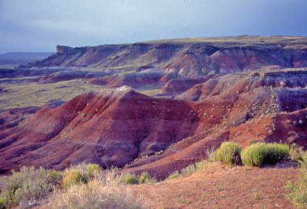
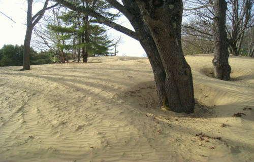
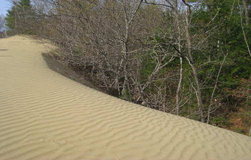
Maine Desert
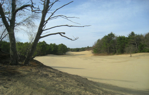
Maine Desert Facts
- Leading off this article about these 7 Deceptively Dazzling Deserts we present one that most people probably remain completely unaware of, the Maine Desert.
- The remarkable location sometimes known by this unexpected name remains an incredibly unexpected feature within its region. This astonishing marvel of the work of Nature also goes by the similarly descriptive common name of the Desert of Maine.
- Regardless of the name one uses, however, one indisputable fact about this site clearly stands out. That’s the fact that this location actually forms a surprising geological phenomenon. Thus, it shows that names can sometimes be quite deceptive.
- That holds true due to the fact that, in the minds and opinions of some individuals, this site does not qualify as a true desert. That perspective occurs because the surrounding climate remains much too wet and cold to meet some definitions.
- The formation of this truly astounding feature, furthermore, did not come about naturally. In point of fact, this quite dry, arid region, whether it constitutes an actual desert or not, actually owes its existence to human activity. That alone sets it apart.
- Nonetheless, the surprising knowledge of its origins does nothing to detract from its fascinating nature. Quite understandably, the very uniqueness of the Maine Desert serves to garner the formation with a more than modest claim to fame.
- This surprising statement holds true due to yet another fascinating statistic. That’s the fact the location has been preserved as a natural oddity. That’s additionally been the case since 1925. A small museum and gift shop also presently exist on the property.
Maine Desert Physical Description
For all the controversy surrounding the Maine Desert, several key facts stand out when one considers it. Firstly, regardless of its origins, it covers a tiny area. Secondly, however, a debate over whether or not it’s actually a desert remains ongoing among concerned scientists.
As a result of this continuing situation, the formation does not officially hold the title of the smallest desert on earth. In fact, for the present moment, at least, the somewhat larger Carcoss Desert, in Canada, also finds itself in the very same predicament.
But, regardless of any official status, the site constitutes an interesting phenomenon. In terms of size, though, the Maine Desert only covers approximately 40 acres (16.2 ha). In this, it aptly demonstrates the fact that size has no bearing on impressiveness.
No matter its official situation, the remarkable feature definitely qualifies as unique, at the very least. That’s due not only to its origins, but also to its very nature. This occurs because it does not, in fact, consist of sand. It’s actually composed of glacial silt.
Maine Desert History and Formation
While it formed only recently, the beginnings of the story of the Maine Desert begins roughly 10,000 years ago. At the end of the last ice age, the glaciers retreated. As they did so, the foundations for the future formation of this fascinating site actually began.
The actual site of this beginning presently represents the state of Maine, in the United States, in North America. During the course of the slow but inexorable retreat of these glaciers, the withdrawing ice sheet went to work creating the masterpiece.
As a result of that movement, the ice ground rocks into a fine powder, known as glacial silt. Over the passage of millennia, copious quantities of topsoil became deposited over this. This finished condition remained comparatively stable for many thousands of years.
Then came huge numbers of European settlers. Eventually, a local family established a farm on this site. This occurred in 1797. Yet the people failed to manage the land properly. Poor farming practices also combined with overgrazing to erode the topsoil.
One day, a small patch of the underlying sand appeared. Furthermore, this formation quickly spread, eventually taking over the entire farm. Subsequent to this development, the Maine Desert was born. To date, it’s depth has never been measured.
Eventually, bowing to the inevitable, the family abandoned the farm in 1919. A man named Henry Goldrup purchased the property in 1925. Recognizing its uniqueness, he opened the site as a tourist attraction. Today, nature appears to be slowly reclaiming the area.
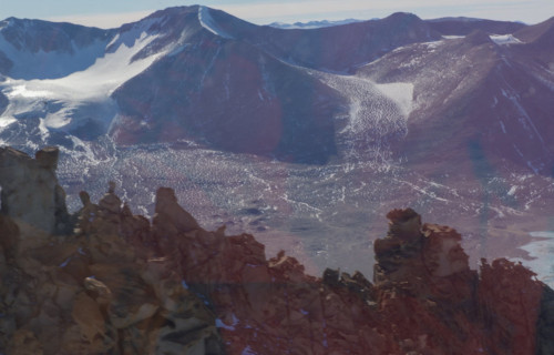
McMurdo Dry Valleys
McMurdo Dry Valleys Facts
- Next up among these choices for inclusion in this compilation of 7 Deceptively Dazzling Deserts comes perhaps the most unique one on the list, the McMurdo Dry Valleys.
- To the surprise of many, the region collectively known by the unsual name easily ranks as one of the most extreme deserts known to man. This fact astounds many who learn of it, simply because most people automatically associate deserts with other attributes.
- This remains especially remarkable given one particular, extraordinary fact. That holds true because the incredible feature formed in a section of the continent now known as Antarctica. Nature, it seems, never tires of astounding us mere humans!
- However, even in this inhospitable environment, life found ways to adapt. It’s not likely the type of life most of you might expect to find. That’s because certain types of photosynthetic bacteria inhabit the comparatively damp interiors of rocks in the area.
- The wonders of evolution to be found here do not end there. That holds true due to the fact that some incredible bacteria live here. More precisely, certain of these with metabolisms based entirely on sulfur and iron appear to thrive under a local glacier.
- McMurdo Dry Valleys includes geological features to amaze the explorer. These include more than a dozen separate valleys and eleven recognized glaciers. Due to a high saline content, liquid water flows in parts of the area, including streams and small lakes!
McMurdo Dry Valleys Geology
Intriguingly, the stunning McMurdo Dry Valleys formed in conjunction with a much larger formation. That’s what the majority of professional geologists call the Beacon Supergroup. This structure formed during a period ranging from 400 – 250 million years ago.
Yet the wonders continue. The unparalled region also cuts through sections of even older rock formations, largely consisting of various types of granite. Relatively large quantities of unsorted glacial sediment, known as tills, also cover the exposed areas of bedrock.
These deposits, in themselves fascinating, appear in widely scattered pockets. These largely differ in composition from tills found in other parts of the world. Most others remain rich in mud. This rather sharp contrast occurs as a result of the unique nature of their origin.
In the remarkable McMurdo Dry Valleys, the tills deposited from extremely cold-based ice. Similar deposits in other regions, however, formed as primarily moist-based. Due to these factors, large amounts of loose gravel also dot the landscape of the region.
McMurdo Dry Valleys Location and Climate
To the continual astonishment of many, the McMurdo Dry Valleys formed in a remote corner of the globe. That consists of one of the southernmost regions of the Southern Hemisphere. More specifically, the formation sits within the region known as Victoria Land.
This geological wonder also sits roughly due west of the site known as McMurdo Sound. The austerely beautiful region additionally has a total area of roughly 1,900 sq mi (4,800 sq km). This accounts for a respectable 0.03% of the total area of the entire continent.
It also, unsurprisingly, represents the largest ice-free region of the continent of Antarctica. The fascinating section of the world derives its name from its remarkable climate. That’s because, despite its location, it remains one of the most arid places on the planet.
This extreme lack of humidity contributes to, but does not solely account for, the lack of any permanent accumulations of snow or ice. The tiny average precipitation of only 100 mm per year occurs also occurs due to the relatively great height of the surrounding mountains.
These features, in themselves awesome, typically serve to prevent the advance of the local ice sheet. This fact plays another part in the nature of the valleys. Yet, the extreme winds in the region, known as katabatic winds, also play a pivotal role in its aridity.
These powerful, relatively warm winds, present within the McMurdo Dry Valleys, often achieve speeds of as much as 200 mph (320 kph). These powerful natural winds, therefore, continually serve to rapidly evaporate any recently deposited ice or snow.
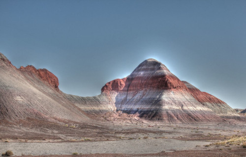
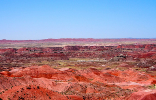
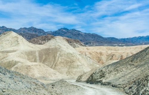
Painted Desert
Painted Desert Facts
- Appearing in the third position in this compendium of 7 Deceptively Dazzling Deserts, the aptly-named Painted Desert does so only due to random selection.
- Perhaps most notably, the term for this site applies to a geological formation unlike anything else in its portion of the globe. That’s instantly obvious to those who see it. Without doubt, this magnificent work of Nature certainly does live up to its name.
- This incredible landscape just seems to perfectly display Nature’s brushstrokes for us to behold and appreciate their majesty. This astonishing geological formation also formed in a region of the world already well known for its many natural wonders.
- In point of fact, the breathtaking site formed in a beautiful but rugged region. This comprises an area that stretches across portions of what now represents both the Petrified Forest National Park and the Grand Canyon National Park.
- One factor of its formation now serves to provide it with a certain measure of protection. The majority of the rugged terrain of the site lies within land belonging to the Navajo Nation. Large portions of the area can only be accessed by foot or dirt roads.
- The truly gorgeous landscape of the aptly named Painted Desert further has a potential dark side to it. Its beauty does come with a bit of a potential price for the unwary. That’s because, while beautiful, the area also remains quite dangerous.
- As a result of this natural characteristic, very specific precautions now exist for the safety of the intrepid and determined visitors. Travelling the rugged dirt roads of the arduous region now requires the acquisition of a very special permit.
Painted Desert Geology
The local Native American tribes take strict, but laudable precautions. These include carefully restricting access to the stunning Painted Desert. This the local population does to protect both its natural beauty, as well as the safety of the tourists themselves.
Thankfully, the traditions of these Indigenous Peoples have always respected the many wonders of Nature. Not surprisingly, this marvelous work of Nature formed from a highly unique combination of extremely slow, but nonetheless inexorable, factors.
That holds true due to the very distinct and complicated nature of the formation itself. This occurs due to the presence of a special combination of stratified layers of mudstone, shale, and sandstone. Millions of years of erosion subsequently exposed those layers.
The layers displayed in the Painted Desert also have different compositions. Each contains large quantities of both manganese and iron. As a result of the presence of these, the different concentrations of the minerals form the source of varying colors and shades.
Painted Desert Location and Climate Base
The wonder of the painted Desert formed in a section of the world already well known for its natural wonders. That’s because it formed in a rugged and remote portion of what’s now known as North America. Even there, though, its great beauty stands out.
More precisely, this wondrous example of the work of powerful geological processes forms part of the area presently known to many as the Badlands. That fascinating region, itself a natural work of art, sits in the remarkable Four Corners portion of the United States.
In addition to the deposits of minerals and subsequent erosion, other factors played a role in the creation of this masterpiece. Layers of ash from ancient volcanic activity contributed their own colors to the beauty of the area. The combination created a vivid effect.
This location deserves notice for yet another reason. That’s due to its sheer size, in total area, as well as its great visual beauty. In fact, the total area of the region equals roughly 93,500 acres (42,500 hectares). However, its size also leads to certain environmental factors.
That holds true since the region also has a unique climate. This occurs due to the rain shadow of the nearby formation known as the Mongolian Rim. As a result, the local summers become hot and dry. Winters in the Painted Desert become quite cold, though.
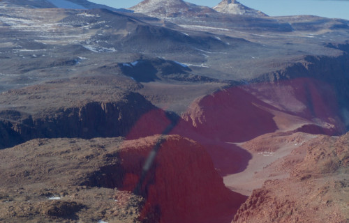
Namib Desert
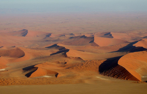
Namib Desert Facts
- Next up in this articlea bout 7 Deceptively Dazzling Deserts we present the amazing geological formation known to most as the Namib Desert.
- Most notably, the astounding formation remains one of the most remarkable and impressive such features in the world. The incredible feature of geology also represents the only true desert to be found in its part of the continent on which it appears.
- This truly spell-binding location actually holds several distinctions that quite clearly set it apart from other deserts. This marvel of Nature additionally appears to be extremely old. In fact, it potentially constitutes the oldest surviving desert in the world.
- The surprising uncertainty exists due to varying opinions among scientists as to its exact age. This astonishing feature also possesses a somewhat unusual shape. Its dimensions remain highly elongated, with its length being roughly ten times its width.
- The amazing Namib Desert also stands out from similar features for the extreme aridity it developed. It earns this recognition even in comparison with the other desert regions around the globe. To be precise, this magnificent site ranks as dry even for a desert.
- Portions of its area rank among the most arid regions of earth, with only the Atacama Desert, in South America, to rival them. Amazingly, this marvel also serves as home to several species found nowhere else on earth, including the awesome Medusas Head.
- Its many extremes further served to earn it an honorable distinction that few similar features can claim. That holds true since that UNESCO named it a World Heritage Site. Of the 23 recognized deserts in the world, only a handful can make that specific claim.
Namib Desert Physical Description
Although the stunning Namib Desert grabs one’s notice for many reasons, physical size isn’t among them. That statement holds true due to the fact that, despite its legitimately impressive numbers, the site only ranks as 23rd among the largest deserts on earth.
This particular desert, although not expansive relative to some, still garners much-deserved notice. To begin with, it must be noted that, like other similar features, the dimensions vary slightly. This, quite understandably, occurs due to various natural processes.
It has an overall length measuring roughly 1,200 mi (1,931 km). Despite this, its overall width generally only averages about 120 mi (193 km). These dimensions, while slightly variable, serve to give the site an extremely elongated, roughly rectangular shape.
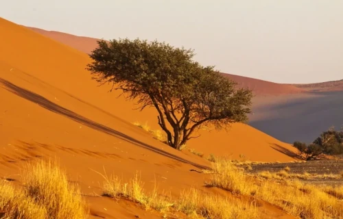
In addition to the ubiquitous sand inherent to its nature, the starkly stunning Namib Desert also boasts other remarkable features. Among these, however, its remarkable and visually impressive sand dunes remain of paramount interest to most viewers.
That’s partly because of their extreme size. Amazingly, these natural formations measure an astounding 980 ft (300 m) high. But, these also extend for a difficult to imagine length of about 20 mi (32 km). Due to that, these rank as the second largest in the world.
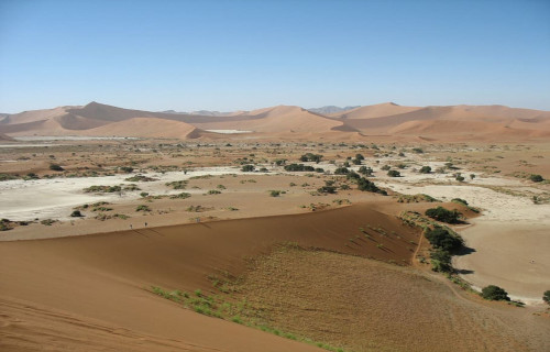
Namib Desert Location, Geology, and Climate
The Namib Desert also formed in a region of the world known for its natural wonders. It sits on the continent of Africa. The confines of this arid wonderland lie within the boundaries of the countries of South Africa, Angola, and Namibia, from which its name derives.
The site also holds another surprise. This desert actually runs along the edge of the continent, abutting the Atlantic Ocean. It also runs from the Angola-Namibia border in the north, to as far south as the Olifant River, located in Western Cape, South Africa.
The region includes a vast dune sea. These dunes exhibit varying colors. These include hues ranging from bright orange to pink. The variations in color result from differences in the mineral composition of the sand. This part of the desert comes from different sources.
The climate of the Namib Desert remains unique. It consists of several extremes. The aridity stems from dry air descending from a global atmospheric circulation. Meanwhile, humid winds from the ocean create frequent dense fogs along the edge of the desert.
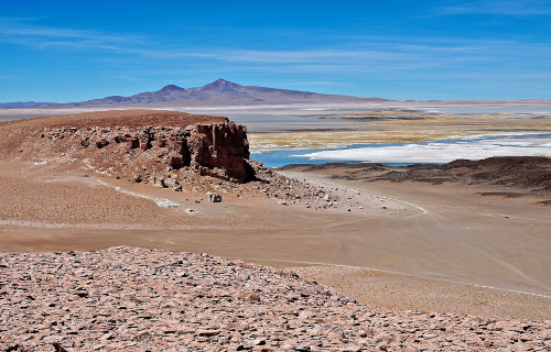
Atacama Desert
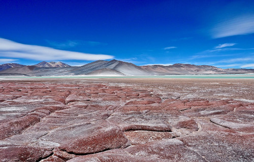
Atacama Desert Facts
- The fifth entry into this compendium of 7 Deceptively Dazzling Deserts is one with an otherworldy ambiance, the remote Atacama Desert.
- In terms of desert-like features, this absolutely breathtaking location puts even most other desert regions to shame! That holds true for several reasons, in fact. First and foremost, this stunning work of Nature ranks as the driest non-polar desert on earth.
- It bears noting that, by definition, a given region qualifies as a desert if its evaporation rate exceeds that of its rate of precipitation. That’s why certain polar regions qualify as deserts, to the surprise of many individuals, believing that desert areas must be hot.
- This wonder of Nature is also the oldest known desert on earth, by far. Evidence places its origins as far back in history as 20 million years, at least. Its extreme nature, as it exists today, however, appears to have only existed for around 3 million years, though.
- Yet its status isn’t earned simply due to this one factor. The stark section of the globe also qualifies as a unique variety of desert, known as a fog desert. That title’s earned when a desert region receives the majority of what little moisture it gets from fog drip.
- The distinctiveness of the fabulous, if stark, Atacama Desert does not go unnoticed or unappreciated by those who value Nature. As a result, portions of the site form a total of 3 protected areas. Sadly, though, these cover only a fraction of the regions total area.
- The sections set aside for protection form either National Parks or National Reserves. They bear the names of Pan de Azúcar National Park, Pampa del Tamarugal National Reserve, and La Chimba National Reserve. Other areas serve as experimentation sites.
Atacama Desert Physical Description
The magnificent Atacama Desert has a distincitve shape, in addition to its other outstanding features. That’s because this stark wonder of Nature has a highly elongated shape. Although its edges are naturally irregular, it’s average measurement is roughly 10 times as long as wide.
More precisely, its average length measures nearly 700 mi (1,120 km). The average width, however, only equals approximately 60 mi (96 km). Both these dimensions vary, of course, due to various environmental factors, though rarely to any significant degree.
These average dimensions give it a total area of roughly 41,000 sq mi (105,000 sq km). Some accounts provide a slightly greater area, though, due to differences in definition. That’s due to the fact that the other calculations include the barren slope of surrounding mountains.
Much of the astonishing Atacama Desert has an otherworldy appearance. This holds true due to the existence of an unusual, and distinctive, combinations of terrain. These include such varied features as salt lakes, stony terrain, ancient lava flows, and of course, sand.
Amazingly, its borders, of all things, qualify as yet another distinguishing characteristic. That distinction occurs because, firstly, on one side its bordered by now one but two mountain chains. And on the other side, to the amazement of many who see it, lies an ocean!
Atacama Desert Location, Formation, and Ecology
The awe inspiring Atacama Desert did not form in a part of the world that most people would expect to find such an extensive desert region. One the contrary, most of the rest of the continent on which it formed remains widely known for its verdant nature.
That’s because this marvel of natural processes formed on what now constitutes the continent of South America. More precisely still, the fabulous site lies on the Pacific coast, slightly west of the mighty Andes Mountains, within the borders of the country of Chile.
The conditions which formed it arose, and are maintained by, a constant temperature inversion. This occurs due to the presence of the Humboldt ocean current, along with a powerful semi-permanent Pacific weather pattern, commonly known as an anti-cyclone.
The driest part of the region lies between the Chilean Coast Range and the towering Andes. Their great height prevents virtually all flow of moisture from either the Atlantic Ocean or the Pacific Ocean. This portion receives an average of only 0.6 in (15mm) of rain per year!
Despite the conditions, life found a way to survive here, and some even flourish. More than 500 species of flora call the region home. These mainly consist of various herbs, along with several small flowers. Several types of trees, and numerous succulents also appear.
Few species of fauna live in the Atacama Desert, but a few manage it, mainly along the fringes. These include insects, such as grasshoppers and beetles. A few types of scorpions and lizards also dwell in its confines. Amazingly, many birds live along the ocean coastline.
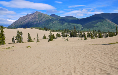
Carcross Desert Facts
- Here, in this listing of these 7 Deceptively Dazzling Deserts, we present yet another location many would never believe possible, the amazing Carcross Desert.
- The location known by the simple name stands out from other similar locations around the world. That’s partly due to its uniqueness. Just like the Maine Desert, its status as an actual desert also remains a source of ongoing debate among scientists.
- Assuming its status as confirmed, this remarkable geological feature further remains one of the northernmost deserts on earth. In point of fact, one of the most astounding things about this very surprising site remains its geographical location.
- That certainly isn’t the only thing that makes this impressive site so fascinating to those visit it, however. Quite interestingly, the story of the conservation efforts for the fabulous Carcross Desert unfolds significantly different from most similar sites.
- For one thing, there remains a most unusual story behind its formation. The beginning of this intriguing story took place in the year 1992. To be more precise, at that time, the local government attempted to enact a conservation program for the region.
- Astonishingly, and unfortunately, the local populace actually rejected the idea. This represented exactly the opposite of what usually happens in such situations. But, the cause was an ulterior motive. The location is popular with the local inhabitants.
Carcross Desert Physical Description
The small but gorgeous Carcross Desert elegantly proves the point that beauty does not depend upon sheer physical size. That statement holds true due to the simple fact that this marvel of Nature has a size that’s dwarfed by the better known deserts of the world.
In fact, this region of the world boasts an area equaling only roughly 6.23 sq mi (16.14 sq km). But, its distinctiveness does not end there. That’s because the entirety of the region of the Carcross Desert remains arid, despite the climate of the surrounding region.
This situation occurs in relation with local weather patterns. That’s due to the rain shadow effect of the nearby Yukon mountains. The distinctive area is also prone to strong winds which continually supply the region with new sand from the shores of Lake Bennet.
Carcross Desert Location, Ecology, and Recreation
Despite the name, the amazing Carcross Desert does not technically measure as dry enough to be classified as a desert. The feature nonetheless remains significantly drier than the surrounding area, though. In point of fact, this extends to the entire country.
That holds true due to the fact that the site receives less than 2 in (50 mm) of rain per year. The rest of the country in which it formed, Canada, has a much damper climate. Despite these highly arid conditions, however, a few hardy plants have adapted to the climate.
Most notable among these is the rare Baikal Sedge. The plant’s only known to exist in four other locations in North America. Another species of flora that flourishes here, despite being extremely rare in surrounding regions, is the lovely but delicate Yukon Lupine.
Geological evidence also shows that the area now forming the Carcross Desert holds a somewhat surprising history. To the great amazement of many, the region once comprised a lake bed. This, however, occurred long ago, back in the Pleistocene Epoch.
To be more precise, as well as technically correct, the area actually qualifies as a close grouping of separate sand dunes. These also appear closely adjacent to the nearby Lake Bennet. Also, the bountiful sand deposited during the last period of glacial activity.
The extremely unusual location further quickly earned the formation a distinct status. That’s due to its popularity for various recreational activities. As a result, numerous local residents, and increasingly tourists, as well, utilize the dunes for several activities.
These include numerous types of locally popular functions. Among these is such frequent uses as hiking, all-terrain vehicular activities, and sand boarding. Finally, the nature of the remarkable site also appears to be rapidly making it a popular site for skydiving.
Death Valley
Death Valley Facts
- Last up in this article about 7 Deceptively Dazzling Deserts, but certainly not least, we present the baffling site descriptively known as Death Valley.
- The term given to the site serves as the name of a severe desert valley. In addition, this marvel of Nature is located in an entirely surprising part of the world. That holds true because it formed in what’s now Eastern California, in the United States.
- Its unique geology helps to make it one of the most astounding of such sites in the world. This makes it the driest, lowest, and hottest region found in North America. This stunning location itself contains features completely unique to this part of the globe.
- Among them sits an area that holds a warm place in the record books. That’s the highly appropriately named Furnace Creek. That’s due to the fact that, in this location, in 1913, the highest air temperature ever recorded was reached; 134 F (56.7 C).
- Yet another feature found within the amazing Death Valley holds a prominent position, at least in scientific circles. This region is known by the unusual name of Badwater Basin. It has the lowest elevation in North America, at 282 ft (86 m) below sea level.
- Its also often dangerous, but still stark, beauty, additionally served it well. The desert region currently forms the cornerstone of the remarkable Death Valley National Park. This, in turn, comprises part of the Mojave and Colorado Deserts Biosphere Reserve.
Death Valley Geology
Death Valley remains considered to be one of the finest examples of its type of feature in the world. The area classifies among scientists as a basin and range configuration. The incredible area also sits at the extreme southern end of a trough known as Walker Lane.
This trough, itself quite impressive, proceeds north into the state of Oregon. The magnificent valley also remains bisected by a slip fault system. Furnace Creek also flows into the remarkable valley. Eventually, however, this dries up in the sands of the valley floor.
Quite noticeably, extensive areas of sand dunes also cover large portions of the Death Valley. In addition, numerous features known as salt pans are also located in the region. These form the remains of several inland seas that were present during the Pleistocene era.
The evaporation of these ancient seas also left behind an extremely impressive natural legacy. Their departure deposited large quantities of sodium and borax This long-term process also left behind large quantities of the minerals sodium and borax.
Death Valley Climate
The astounding feature aptly known as Death Valley fully earns its name. That’s due to the fact that it possesses a quite extensive subtropical, hot desert climate. This climate remains categorized by its long, extremely hot summers, followed by very short warm winters.
Rainfall also remains scarce and sporadic throughout the entirety of the region. More precisely, such moisture continues to be virtually non-existent in some portions of the site. Also, when the sun heats the air, what little does arrive evaporates with extreme speed.
The high valley walls also help add to the arid climate of the region. These structures efficiently serve to circulate the hot air back down to the floor of the valley. There it quickly becomes heated to even higher temperatures by the process of compression.
In addition to this, yet another condition adds to the situation. The density of the below sea level air further augments the already powerful process. It accomplishes this by reflecting even more of the already overwhelming heat downwards, back into the valley.
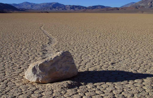
Death Valley Phenomenon
Death Valley also serves as home to a unique phenomenon that had baffled scientists since the 1940’s. Many referred to this as the sailing stones. In a remote region of the valley, known as Racetrack Playa, numerous stones of varying sizes litter the sandy floor of the playa.
Over the decades many of these stones appeared to move, leaving tracks in the sand. These also left behind no apparent explanation. Finally, in 2014, a team of researchers managed to catch the phenomenon in Death Valley in action, and explain it.
Under a rare and unique combination of conditions during the winter, thin sheets of ice form on the floor of the playa. Winds drive the stones slowly across the playa floor, as the ice also breaks up. The process also occurs rarely, and too slowly to be viewed by the naked eye.
7 Deceptively Dazzling Deserts
We sincerely hope that you have thoroughly enjoyed reading, and hopefully learning from, this article about these 7 Deceptively Dazzling Deserts. It’s also our fervent hope that doing so has left you inspired to learn of more such marvels of Nature around the world.
Sadly, though, many related natural marvels find themselves facing degradation, or even outright destruction. In many instances, this situation arises as a direct result of human activities. It’s up to each of us to do all that we can to protect and preserve such marvels.
Check out our other articles on 5 Surprising Freshwater Animals, Earth’s Many Stunning Waterfalls, 6 Magnificent Carnivorous Plants, Wonderful Wild Cats of the World