


CCL: https://bit.ly/2X8vYgB
We sincerely hope that you enjoy this article about 7 Highly Unusual Lakes. Now, to be certain, the world has countless lakes, of all shapes and sizes. And most, if not all of them, have their appeal. However, once in a while Nature likes a little variety. These particular lakes represent our choices of just a small representative selection. So, sit back, and enjoy reading and learning about these 7 Highly Unusual Lakes.
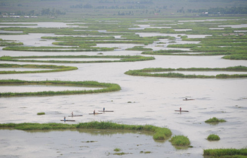
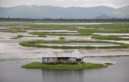
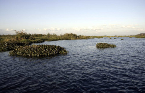
Loktak Lakes

CCL: https://bit.ly/37X3BWx
Loktak Lake Facts
- Leading off our article about 7 Highly Unusual Lakes is the incredible body of water known as Loktak Lake.
- The magnificent body of water truly constitutes one of those locations that will mesmerize and astound you. That’s because this astonishing lake in fact remains very much unlike other lakes throughout the world. Furthermore, it can make this claim for several different reasons. Some of these occur directly, others in an indirect manner.
- First of all, the marvelous geological feature holds several directly occurring claims to fame. For starters, this breathtaking body ranks as the largest known freshwater lake in its particular portion of the globe. Secondly, It boasts an incredible array of unique and fascinating, free-floating composite features known as phumdis within its boundaries.
- Indirectly, however, the site also remains important within its region of the world. Due to a combination of location and coincidence, it represents the last known refuge for an endangered animal species known as the Sangai. It also forms an important economic function in the region. Many local fisherman rely on it, and it serves as a source of hydroelectric power.
- Quite fortunately for those who appreciate Nature, efforts to preserve the region remain underway. Partly due to the presence of the phumdis, the southeastern section of the lake now forms the Keibul Lamjao national park. It’s the only floating national park in the world. The coincidental fact that the spot also forms the last known habitat of the Sangai serves as the other reason for the creation of the park.
CCL: https://bit.ly/2T2LGd0
Loktak Lake Physical Description
To the surprise of some, the most remarkable thing about the gorgeous Loktak Lake isn’t its physical size. Nevertheless, this marvel of geology does rank as a moderately large freshwater body, even more so in the area in which it formed. Understandably, its dimensions naturally vary over its extent, but certain measurements of the impressive body remain possible.
For starters, the marvelous geological feature has a maximum measured length of roughly 22 mi (35 km). The truly amazing location also has a maximum measure width of about 8 mi (13 km). These dimensions give the natural wonder an overall roughly oblong shape. Furthermore, the site also has a total surface area measuring roughly 111 sq mi (287 sq km).
However, the wonderful Loktak Lake, for all its incredible splendor, may surprise you with its depth. That’s because, for a lake of its other dimensions, one stands out as hard to believe. That holds true due to the fact that its maximum measured depth of reaches a mere 15.1 ft (4.6 m). But the average depth of the unique body only equals a meager 8.9 ft (2.7 m).
CCL: https://bit.ly/3cbh9Bh
Loktak Location, Formation, and Ecology
The fabulous location of the incredibly exotic marvel of Nature called Loktak Lake may come as no surprise to some of you. That’s because the marvel formed in a region already filled with countless other wonders of the natural world. That’s the region now known as the country of India, in Asia. More specifically, it lies in the northeastern part of the land.
In addition to everything else, this site owes its formation to the actions of not one, but two local rivers. These sources bear the local names of the Barak River and the Manipur River. Furthermore, much like the lake itself, these have a gentle slope, and often meander through their flow patterns. The site also has a highly convoluted drainage system, like the roots of a tree.
The area in which Loktak Lake formed has a monsoon climate, and receives copious amounts of rainfall. As a result, it boasts an impressive array of plant life adapted to living in water. In fact, its rich biological diversity includes a total of 233 known species of aquatic plants. However, doubtless the remarkable phumdis, floating islands made of soil, plants, and organic matter, remain the best known.
But, the remarkable list of life the area does not stop there. Firstly, avians thrive here. A total of 57 types of waterbirds live around it, along with 28 varieties of migrating waterfowl, and 14 species wetland birds. Secondly, 249 known species of vertebrates, and 176 types of invertebrates also inhabit the surrounding terrain. But, the best known of these remains the Endangered Sangai, which has no other known habitat.
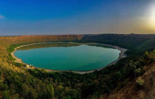
Lonar Lake
CCL: https://bit.ly/1xMszCg
Lonar Lake Facts
- Our next choice for inclusion among these 7 Highly Unusual Lakes is the breathtaking location known as Lonar Lake.
- First of all, the stunning site remains an extremely rare type of feature. That’s because the site in fact represents one of only four known examples of lakes formed from a highly specific combination of factors. This fact alone sets it apart from the majority of lakes.
- Furthermore, due to its highly unique nature, the government of the region it formed in assigned it a special status. The incredible site now holds the classification of a National Geo-heritage Monument. This action should serve to provide the lake with a measure of protection.
- However, a great debate currently rages among geologists. This occurs concerning the exact age of Lonar Lake. Firstly, some scientists estimate that it formed around 52,000 years ago. Meanwhile, others believe its formation actually occurred roughly 570,000 years ago.
- Furthermore, due to its unusual nature, many institutions have undertaken extensive studies of the site. These investigating bodies include the Smithsonian Institution and the United States Geological Survey, among others. These studies presently remain ongoing.
CCL: https://bit.ly/1iowB8m
Lonar Lake Physical Description
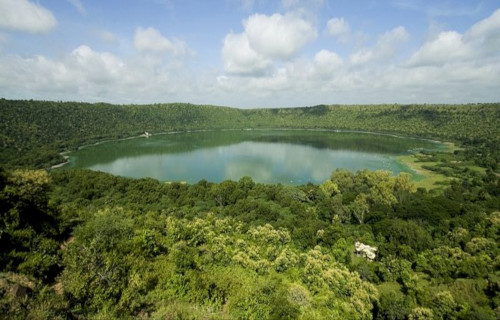
Firstly, the gorgeous Lonar Lake remains an extremely large lake. This fact especially holds true considering its origins. That’s because this wonder of Nature has a average width of roughly 3,900 ft (1,200 m). Furthermore, the lovely formation also has a maximum measured depth of 490 ft (149 m).
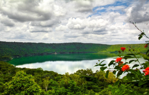
Furthermore, the water of remarkable Lonar Lake itself remains quite impressive in its own right. This ranks as true due to the fact that it contains quantities of numerous sodas and salts. During periods of dry weather, when the water level recedes, locals gather large quantities of soda left behind.
Also, two small streams, themselves quite lovely, also empty into the lake. These flows bear the names of Penganga and Purna, This action, therefore, helps maintain its levels under normal conditions. In addition, a well of fresh water can be found on the southern side, near the edge of the lake.
CCL: https://bit.ly/1p2b8Ke
Lonar Lake Location, Formation, and Ecosystem
It bears remembering that the marvelous Lonar Lake also stands out for yet another impressive region. In point of fact, the body of water sits in a rather remote and somewhat rugged part of the world. The fabulous site formed in what now constitutes the Maharashtra state, in India, in Asia.
But the formation of the magnificent and unique spot easily remains the most notable fact about the location. That’s because it actually formed as the result of a meteor strike into a large deposit of basalt. As one of only four such known, it is also the only one not found in Brazil, in South America.
Furthermore, the surface of the lovely Lonar Lake itself actually sits in a surprising location. That’s because it sits roughly 449 ft (137 m) below the rim of the old impact crater. However, the enormous crater created by the meteor strike itself has a diameter measuring about 5,900 ft (1, 800 m).
Furthermore, its distinctive combination of qualities has also led to yet another astonishing feature. That’s the formation of a truly remarkable ecosystem located within its boundaries. This amazing ecosystem comprises two separate and quite distinct sections that do not interact at all.
In a fascinating development, the inner section has an alkaline base, while the outer one does not. Quite amazingly, each also has its own flora and fauna. Overall, however, the site forms a haven for a wide variety of species. These include gazelles, monitor lizards, and numerous types of migratory birds.
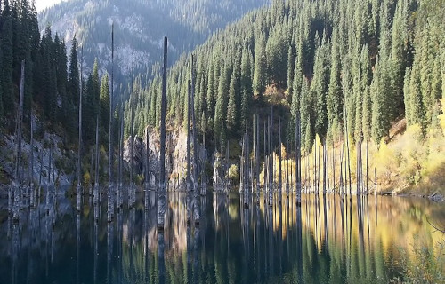
Lake Kaindy
CCL: https://bit.ly/3ynGNwH
Lake Kaindy Facts
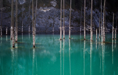
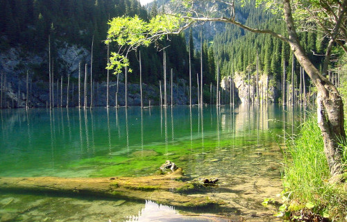
- The third of our selection for inclusion in this compendium of 7 Highly Unusual Lakes is the stupefying Lake Kaindy.
- To begin with, the extraordinary geological marvel has a remarkably recent time of origin. That’s because this marvel actually formed relatively recently due to an earthquake.
- In addition, the water remains quite cold. Due to a specific combination of factors, the water temperature rarely rises above 43F (6C). These conditions have aided in creating a truly remarkable location. It truly earns its spot among these 7 Highly Unusual lakes.
- Though the location of the lake can’t be called particularly remote, the surrounding terrain can be quite rugged. As a result of this, the scenic beauty of Lake Kaindy receives relatively few visitors.
- The most noteworthy aspect of the lake actually involves what lies within the lake. Its pristine waters contain a small forest, which has been completely upturned and preserved relatively unchanged.
CCL: https://bit.ly/2Vd7HcF
Lake Kaindy Physical Description
Firstly, it bears mentioning that, even without the startling presence of the bewildering flora within it, Lake Kaindy remains a lovely sight to behold. Secondly, this holds true, in part, due to the gorgeous color of the typically placid waters.
That’s because the frigid waters of the natural marvel maintain a brilliant bluish-green hue at all times. This occurs due to the strong presence of limestone deposits in the surrounding rocks. Minerals from these slowly erode into the water.
Furthermore, the stunning body of water also has a generally irregular, oblong shape. In addition, this shape understandably varies slightly as water levels rise and fall. However, the lake does maintain a roughly equal maximum depth.
Overall, this measured depth typically equals approximately 98 ft (100 m). Additionally, the beautiful Lake Kaindy also possesses a surprising maximum length. In point of fact, this dimension actually equals about 1,300 ft (400 m).
CCL: https://bit.ly/3qME9xU
Lake Kaindy Location, Formation, and Distinctiveness
The incredibly mesmerizing Lake Kaindy formed in a remote section of the country of Kazakhstan, located in central Asia. More precisely, however, the remarkable site lies about 80 mi (129 km) east of the city of Almaty. Quite fortunately for those who deeply appreciate and value Nature, this location coincidentally lies within the borders of the Kolsai Lakes National Park.
Furthermore, the dazzling body of water also sits at a surprising altitude. That’s because the surface of the lake lies at roughly 6,600 ft (2,000 m) above sea level. However, the stunning body of water has not always existed. This holds true because of the fact that the lake itself formed quite recently, in the year 1911. This formation occurred due to the actions of an earthquake.
The powerful quake, which measured 7.7 on the Richter scale, also generated an enormous landslide. Of further importance remains the fact that this action occurred in a large gorge, composed primarily of limestone. The landslide itself blocked the entrance to this gorge, creating a natural dam. Subsequently, a nearby mountain river filled the region with water.
Nevertheless, the most noteworthy feature of gorgeous Lake Kaindy undoubtedly remains what lies within its waters. That’s because the landslide that formed it, also deposited hundreds of trees within it, most of them literally turned upside down. Even though more than a century has elapsed, the trees remain. The extremely cold water has preserved them.
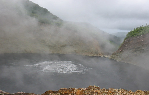
Boiling Lake
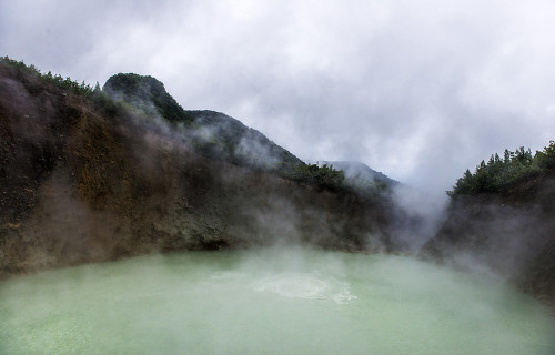
Photo: Göran Höglund (Kartläsarn)
CCL: https://bit.ly/3w716Nr
Boiling Lake Facts
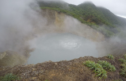
- Appearing next in this listing of 7 Highly Unusual Lakes is the astonishing location known as Boiling Lake.
- Perhaps the most noteworthy fact about the location remains its quite impressive status. That’s because the wonder of Nature ranks as the second-largest hot lake in the world. In addition, it itself forms part of the Morne Trois Pitons National Park, which is a World Heritage Site.
- It also has an impressive recent history. This holds true due to the fact that the first ever recorded sighting of this geological marvel occurred in 1870. This was carried out by Edmund Watt and Henry Nicholls. Also, the first scientific investigation of the site took place in 1875.
- Not only does the aptly-named Boiling Lake remain extremely unique, but it holds another notable claim. That’s because its location also ranks as somewhat remote. In point of fact, the nearest road sits about 8.1 mi (13 km) from the site. Therefore, access remains quite limited.
- Interestingly, the site also stays fairly active. Due to this, it will occasionally drain, and even form geyser-like fountains of hot water and steam. Occasionally, it will even empty and refill amazingly fast. Further, this complete cycle sometimes occurs in only a single day.
CCL: https://bit.ly/3jyrTjk
Boiling Lake Physical Description
Firstly, the dimensions of the Boiling Lake remain constantly variable. This occurs largely due to local conditions. Typically mild phreatic eruptions in the region occur periodically. Understandably, these dramatically affect the level of the small lake.
However, its diameter maintains a fairly regular size range. As a result, it averages between 200-250 ft (61-76 m) across. The depth of the lake naturally also varies. However, an average depth has been determined to be about 195 ft (59 m).
In addition, the color of the water of Boiling Lake also frequently varies. These stunning hues change, sometimes becoming green. But these remarkable colors usually range from grayish-blue to bright blue. In addition, the temperature of the body of water generally ranges between 180-197 F (82-92 C).
Further, this flooded fumarole sits amid jagged, rather formidable outcroppings of rock. These dangerous features themselves average approximately 100 ft (30 m) in height. In addition to the ever-present steam, the site will also occasionally spew forth various noxious gases as well.
CCL: https://bit.ly/3qFeVl7
Boiling Lake Location and Formation
The beautiful yet dangerous Boiling Lake sits about 6.5 mi (10.5 km) east of the town of Roseau. This town lies in the country of Dominica, near South America. Consequently, the site not only has the distinction of being remote, but the surrounding terrain also presents extremely rugged conditions.
Furthermore, the water of the lake itself originates from two separate sources. These consists of typically plentiful rainfall and two small streams that flow into the site. As a result of this inflow, the incoming water becomes super-heated by proximity to the underlying magma chamber.
However, the remarkable appearance of the hot water itself remains independent of the heating action. This occurs because various combinations of minerals in the water create the color. Being rather porous in nature, the surrounding rocks also allow the water to escape rapidly when the nearby volcanic activity interrupts the regular inflow.
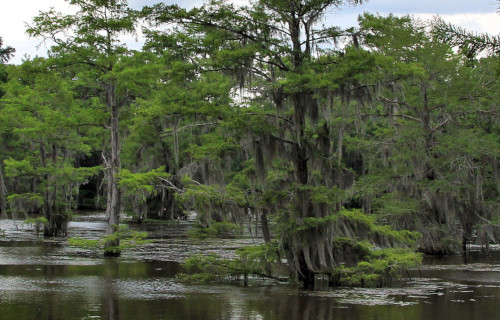
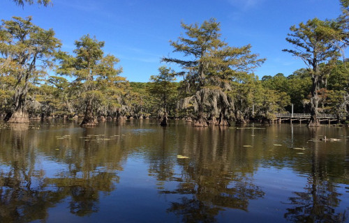
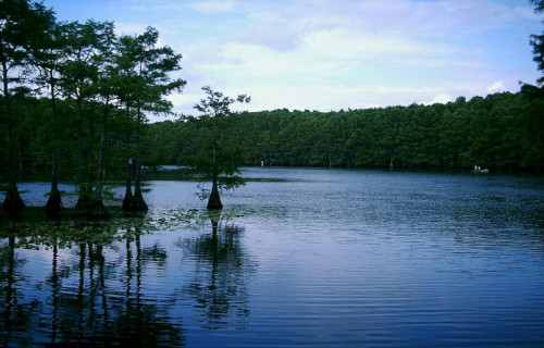
Caddo Lake
CCL: https://bit.ly/2X8vYgB
Caddo Lake Facts
- The fifth of the locations selected for this article on 7 Highly Unusual Lakes is the remarkable Caddo Lake.
- First of all, it must be mentioned that the marvelous lake immediately sets itself apart from other the majority of lakes. In fact, it represents a very special type of lake. That’s because the magnificent geological feature actually combines a moderately large lake with a bayou.
- Furthermore, the beautiful location also has a rather distinctive name, originating with the Native American tribe native to the area. The Caddo lived around the lake, depending upon it for much of their livelihood. The tribe lived there until their expulsion from the region in the 19th century.
- Not only is this gorgeous site a source of great natural beauty, but Caddo Lake also plays a role of vital ecological importance in the region. As a result of this high degree of environmental impact, it now constitutes an internationally protected wetland, under the auspices of the Ramsar Convention.
CCL: https://bit.ly/2qNJUAw
Caddo Lake Physical Description
Most notably, the fabulous Caddo Lake represents a comparatively large example of its uniquely specific type of geological feature. That holds true due to the fact that the impressive site actually has a total surface area measuring around 26,810 acres (10,850 ha).
In addition, the remarkable location actually sits at a surprisingly low elevation. In fact, the surface of the lake sits at an average altitude above sea level of only 161 ft (49 m). However, the precise altitude naturally varies slightly due to such factors as rainfall and evaporation.
But, quite surprisingly, the average depth of the bayou portion of the fascinating Caddo Lake remains different than that of the lake itself. The lake itself has an average depth ranging from 8 – 10 ft (2.4 – 3.0 m). Meanwhile, the bayou actually averages a depth of roughly 20 ft (6.1 m).
CCL: https://bit.ly/2Qertj5
Caddo Lake Formation, History, and Ecology
Firstly, the truly incredible Caddo Lake formed in a unique location. That’s because the site now straddles the border between two states in the United States, in North America. Secondly, and more specifically, this marvel of Nature sits on the border between the states of Louisiana and Texas.
However, the exact time period in which the lake formed, as well as the manner in which it formed, remains a subject of debate. Firstly, the legends of the Caddo state that it formed as a result of a series of powerful earthquakes, that occurred between the years 1811-1812. Truly, it earns this spot among these 7 Highly Unusual Lakes.
But secondly, some experts think it formed in an entirely different manner, and at a slightly later date. That’s because these experts believe it formed due to the occurrence of a gargantuan log jam. This log jam, which blocked a 100-mile (160 km) stretch of the Red River, occurred in the 1830’s.
Further, the local Native Americans used the lake for their purposes for untold centuries, perhaps longer. Commercial development, however, began in earnest in the 19th century. This happened subsequent to the invention of the steamboat, and the acquisition of the region by the United States.
Not surprisingly, in addition to its own natural beauty, Caddo Lake also serves as home to an impressive array of plant and animal life. Most notably among the flora is the extensive cypress swamp. Yet, the area also hosts large numbers of eagles, frogs, bobcats, otters, alligators, and North American Beaver, to name just a few species.
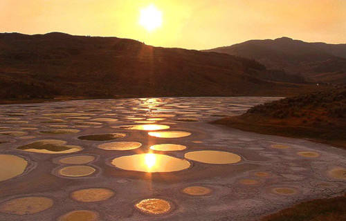
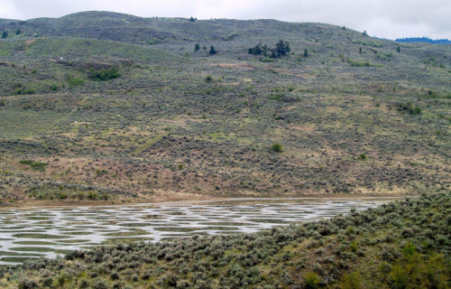
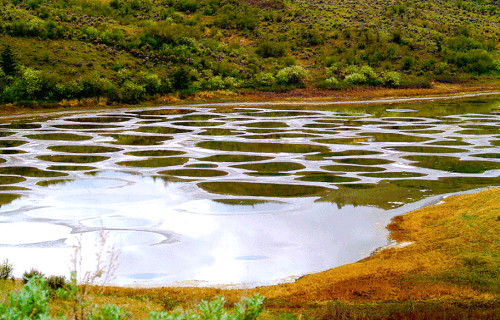
Spotted Lake
CCL: https://bit.ly/3xliBv3
Spotted Lake Facts
- The next awesome entry into this article about 7 Highly Unusual Lakes is the amazing Spotted Lake.
- The most noteworthy thing about the incredible location appears in the form of spots that materialize on its surface. In fact, these highly distinctive formations appear on a very regular basis. That’s because the features appear each summer as the water within the lake slowly evaporates.
- This astonishing geological site also played a surprising role in the history of the immediate region. The indigenous First Nations peoples of the region have considered its waters sacred for centuries. During World War 1, its minerals were used in the making of munitions for use by the Allies.
- The private owners of the land sold it to the Okanagan Syilx peoples, and today it forms a protected area. A protective barrier has also been erected around the site, restricting public access. The location remains both a sacred site and a source of traditional medicine for the First Nations.
CCL: https://bit.ly/2W4pTDG
Spotted Lake Physical Description
To begin with, the mesmerizing uniqueness of Spotted Lake does not rely on sheer size. That’s because it actually represents a very small lake. In point of fact, the site only has a maximum length of about 0.43 mi (0.7 km). Furthermore, it also only possesses a maximum width of roughly 0.16 mi (0.25 km). Further, it only has a total shore length of about 1.1 mi (1.7 km).
In addition, the lake itself also has another layer of variability. That holds true due to the fact that the altitude of the surface of the distinctive lake routinely varies. This occurs because of its constant evaporation with the seasons. Yet, on average, Spotted Lake sits at an altitude of 1,880 ft (573 m).
The distinctive circles themselves also vary in size, depth, and number each year. Yet, though their numbers vary, they average exactly 365 each year, one for every day of the year. While this appears to be a completely random occurrence, it nevertheless serves to add to the unique aura of the location.
CCL: https://bit.ly/2W4pTDG
Spotted Lake Location and Distinctiveness
While the remarkable Spotted Lake isn’t the only alkaline lake in the world, it’s certainly one of the most distinctive. This marvel of nature also formed in a somewhat remote area of the world. That’s because it formed in the area of the Similkameen Valley, in British Columbia, Canada, in North America.
Furthermore, the incredible site primarily contains great quantities of several minerals. These notably include calcium, magnesium sulfate, and sodium. In addition, it also contains smaller quantities of other minerals, and even trace amounts of titanium and silver suspended in its water.
When the water evaporates, the remarkable features of Spotted Lake appear. That’s due to the fact that these remain behind as deposits sitting on the newly dry lake bed. Since each spot forms independently, they also appear in different colors. The randomness occurs as a direct result of varying mineral composition.
The local Okanagan Syilx peoples, of the First Nations, continue to use the waters of the lake for medicinal purposes. The lake is a sacred site to their people, and numerous cairns surround the lake, containing graves. It’s primarily for this reason that the site remains fenced off from tourists, yet it can be viewed from nearby.
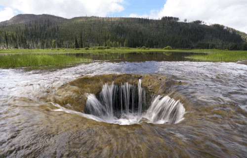
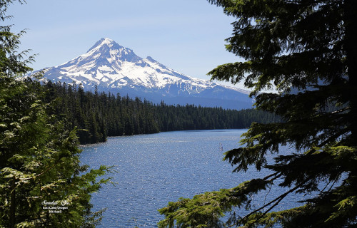
Lost Lake
Lost Lake Facts
- The seventh and final entry into this compendium of 7 Highly Unusual Lakes, known as Lost Lake, truly earns the distinction.
- Most notably, the body of water popular as Lost Lake represents a truly fascinating geological oddity. That holds true due to the fact that each year the entire lake disappears during the winter. However, the disappearance does not occur due to evaporation, as you might expect.
- That’s because an extraordinary event takes place in this remarkable location on an annual basis. Routinely, the entire volume of water in this quite lovely, but otherwise unassuming lake, vanishes. However, in its case, this water quite literally vanishes down a hole in the ground.
- Furthermore, its existence never formed a secret to the indigenous population inhabiting the region. In point of fact, local Native Americans have long known of the uniqueness of the site. They called the lake Kwoneksamach. European Americans first discovered it in the 1870’s.
- In addition, in our current age, this visually rustic, and rather mysterious lake now plays an important role in the local region. That’s due partly to the fact that it remains quite popular with photographers. Furthermore, Lost Lake also now represents a highly popular camping site.

Lost Lake Physical Description
While the presence of the remarkable vanishing water makes Lost Lake unique, it has much to offer even aside from this. That’s because the lake itself has its own beauty and appeal. Further, it also ranks as the second-deepest lake in its particular portion of the country in which it formed.
For starters, the wonderful body of water has a marginally oval shape to it, being only slightly longer than it is wide. Firstly, the lake has a maximum measured length of roughly 5,395 ft (1,644 m). Secondly, the maximum measured width of the body of water equals about 4,150 ft (1,260 m).
Furthermore, provided its length and width, the natural wonder has a respectable area of coverage. Its measurements give the gorgeous and surprising Lost Lake a surface area of roughly 245 acres (99.1 ha). Additionally, it also boasts the impressive maximum measured depth of approximately 167 ft (51 m).
CCL: https://bit.ly/3ht30nF
Lost Lake Location, Formation, and Mystery
The small, but truly lovely Lost Lake lies in an intentionally undeveloped portion of its continent. That’s because it formed in Santiam Pass, Oregon, in the United States, in North America. In addition, the magnificent and mysterious body of water forms part of the Mount Hood National Forest.
The awesome site itself further sits amid even more natural beauty. To begin with, to the east it remains bounded by the huge Lost lake Butte, which stands 4,468 ft (1,362 m) high. Further, to the southwest lies the 4,556 ft (1,389 m) Preachers Peak. It also receives it water from a total of three creeks.
However, the most astounding feature of this fascinating site doubtless remains the mystery surrounding the vanishing water. That holds true due to the incredible fact that its outlet continues to remain a complete enigma. In conclusion, in fact, despite numerous studies and investigations, no outlet for the disappearing water has ever been found by anyone.
CCL: https://bit.ly/3qME9xU
7 Highly Unusual Lakes
We hope that you have enjoyed this article about 7 Highly Unusual Lakes. These, of course, represent only a handful of the lakes available for your viewing pleasure throughout the world. They are, however, some of the most distinctive. However, many of these wonderful features need our protection, to preserve them in their natural state, for our posterity.
Check out our other articles on 4 Geological Wonders of Antarctica, Earth’s Many Mesmerizing Cephalopods, Spectacular Dolphins Throughout Our World, 6 Geological Marvels of Oregon