


CCL: https://bit.ly/2XDyRuE
It’s our hope that each of you, our readers, will enjoy and appreciate this article we present about these 7 Magnificent West Coast Marvels. It was certainly our pleasure to gather the information for you. May it provide you with both education and increased awareness.
Certainly, these locations listed herein represent only a portion of the wonders found throughout this amazing region. It’s our belief, though, that they serve as excellent representations of the marvels found here. Check out some of our other articles, as well.
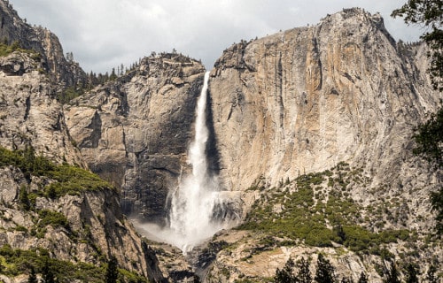
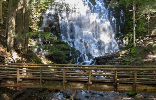
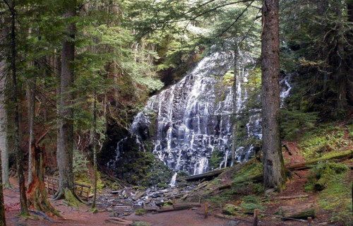
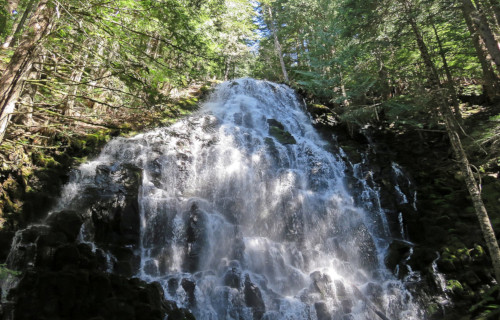
Yosemite Falls
Yosemite Falls Facts
- Leading off this compilation of 7 Magnificent West Coast Marvels we present you with the geological masterpeice named Yosemite Falls.
- The truly magnificent and often breathtaking feature known by this name forms the highest known waterfall in its part of the world. Although beauty remains relative, many also consider it one of the most beautiful features of its kind.
- This astounding work of geological forces also now forms a principal part of the Yosemite National Park. It comprises one of the key attractions of the park, in fact, especially in the spring, when the water flow usually reaches its peak levels.
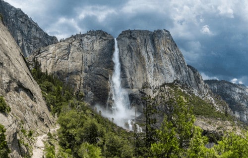
- This wonder of Nature has also played an important role in local history. The base of the gorgeous formation once served as the location of the main village of the indigenous Native Americans of the valley, named the Ahwabneechee tribe.
- The comparatively quite large plunge pool at the base of the waterfall served as a central component of their lives, as well as their mythology. In their native language, the original name for what’s now known as Yosemite Falls was Cholock.
- Given its great natural beauty, this incredible location currently represents one of the most popular tourist attractions in the National Park. In fact, an astonishing average of 4 million people visit this park, and this cascade, each year.
Yosemite Falls Physical Description
While the marvelous visual appeal of Yosemite Falls doesn’t depend on sheer height alone, that characteristic nonetheless remains quite impressive. The total measured height of the stunning waterfall actually measures roughly 2,425 ft (739 m).
The breathtaking site further constitutes what’s known as a multi-tiered waterfall, being, in fact, composed of three primary divisions. These distinct, be equally remarkable, sections, man now calls the Upper Fall, the Middle Cascade, and the Lower Fall.
Purely by itself, the mind-blowing section logically named the Upper Fall plunges approximately 1,430 ft (440 m). This portion alone stands apart as one of the twenty highest waterfalls on earth. The forces of nature, however, did not merely stop there.
The Middle Cascades account for drop of 675 ft (206 m). This section actually comprises five smaller, individual falls. The Lower Falls drop the final 320 ft (98 m), while the large plunge pool at its base remains surrounded by a highly treacherous jumble of talus.
CCL: https://bit.ly/1p2b8Ke
Yosemite Falls Location, Distinctiveness, and Dangers
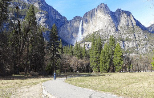
The truly gorgeous Yosemite Falls justifiably remains considered one of the most beautiful sites in its region. This geological beauty lies situated within the Sierra Nevada mountain range, in California, in the United States, which lies in North America.
Each year, unless rainfall totals in the surrounding region surpass the usual, a most surprising event occurs. To the amazement of those who experience it, the usually impressive flow of water ceases entirely during either the late summer or fall.
Rock climbers occasionally take this opportunity to scale the normally inaccessible rock face at this time. However, this remains extraordinarily dangerous. One scattered thunderstorm could send a surge of water over the falls, plunging the climbers to their deaths.
The local Ahwabneechee tribe hold a very specific legend concerning what’s now known as Yosemite Falls. According to that belief, the plunge pool at the base of the falls is inhabited by the spirits of several witches, collectively known as the Poloti.
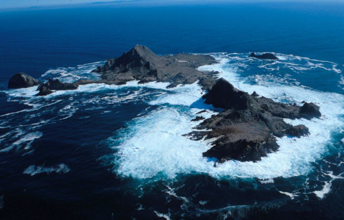
Farallon Islands
Public Domain Image
Farallon Islands Facts
- Appearing next in this article dealing with 7 Magnificent West Coast Marvels comes the distinctive feature known as the Farallon Islands.
- Remarkably, this formation constitutes a small grouping of islands, outcroppings, and shoals, that many people remain completely unaware of. Astoundingly, however, that lack of awareness even extends to many of the inhabitants of the local area itself!
- That’s because, also known as the Farallones, the collection of formations remains something of a mystery to many. One other commonly used named collectively applied to the geological structures provides an indication of one reason for this.
- Many mariners, even today, have a high degree of respect for its dangers. These refer to the structures as the Devil’s Teeth Islands. That’s due to the presence of an unusually high concentration of treacherous underwater shoals around most of the formations.
- Members of local Native American tribes knew of the structures for centuries prior to the arrival of European explorers, of course. Records indicate, though, that even these intrepid explorers never ventured to them, due to their dangers, and religious beliefs.
- It’s believed that members of the Juan Cabrillo expedition, in 1542, were the first non-indigenous individuals to see them. The first confirmed sighting, however, occurred in 1579, by members of the expedition of the English privateer Sir Francis Drake.
- Currently, the Farallon Islands form the core of the Farallon Islands National Wildlife Refuge. Due to this, researchers form the only permitted visitors. This further extends to the surrounding waters, forming the Greater Farallones National Marine Sanctuary.
CCL: https://bit.ly/3b6HJw1
Farallon Islands Physical Description
The starkly beautiful Farallon Islands represent an impressive combination of small islands and sea stacks. As such, they easily impress those who see them in a number of ways. Sheer physical size, however, doesn’t rank among those factors that make an impression.
That’s due to the fact that, both individually and collectively, these formations remain comparatively small in size. The dozens of individual formations come in widely varying shapes and sizes, though. Each further presents its own distinctive nature to the viewer.
In total, however, the entire group only covers an area equaling approximately 103.6 sq acres (41.9 sq ha). A single island, known as Southeast Farallon Island, furthermore, holds the vast majority of the total area. This island measures roughly 95.8 sq acres (38.78 sq ha).
Most of the impressive islands and seas stacks also display a prominently pyramidal shape. The highest point of any of the formations, though, only measures about 357.6 ft (109 m). Some of the various islands do, however, have relatively small flatter areas.
The inexorable process of erosion, both by wind and wave, has also helped shape the intriguing Farallon Islands. This holds especially true of the many sea stacks. Many of these present passageways and even keyhole-shaped openings through the structures.
CCL: https://bit.ly/2Zer6vA
Farallon Islands Location, Formation, History, and Ecology
The visually stunning Farallon Islands formed in a part of the world already well known for its abundance of geological marvels. That’s because it formed as part of the continent of North America. Its precise location, though, may come as a surprise to many of you.
That’s due to the fact that it actually sits in an area bearing the similar name of the Gulf of the Farallones. It’s just 30 mi (48 km) off the coast of the city of San Francisco, California, in the United States! On a clear day, in fact, it’s actually visible from the mainland.
The various components of this remarkable formation represent tiny outcroppings of the Salinian Block. That’s a huge granitic portion of the local continental crust. Movement of the Pacific Plate eventually moved it to its present location over a vast period of time.
The current name of the formation arose from the words of Friar Antonio de la Ascencion. He formed part of another expedition to the region, in 1603. For several centuries following this time, seal hunters heavily exploited the islands, for both seal fur and eggs.
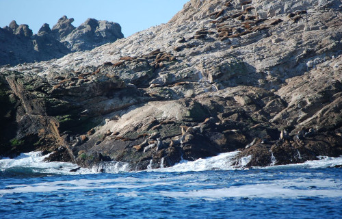
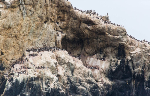
Despite the stark landscape of most of the Farallon Islands, a surprising number of animals appear there. In fact, one of the largest seabird colonies in all of North America resides on the islands. Large numbers of migratory birds also stop over on these formations.
A total of five species of pinnipeds also either live on or visit the site. This includes both seals and sea lions. Several varities of whales also appear in close proximity to the islands and sea stacks. The huge number of pinnipeds, however, also draws quite a few sharks.
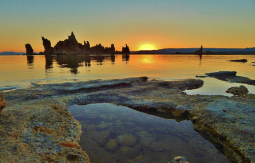
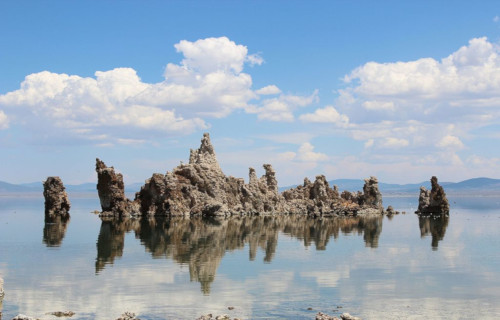
Mono Lake
CCL: http://bit.ly/2N3jmAM
Mono Lake Facts
- Our next choice for inclusion in this gathering of these 7 Magnificent West Coast Marvels, Mono Lake, remains renowned for its wonders.
- The relatively simple title it holds represents the name of a particularly impressive, and quite distinctive, body of water. Despite the comparative harshness of the surrounding environment, the site has a unique form of beauty all its own.
- The formation also has a highly unique history, extending far back into antiquity. In more modern times, ancient Native Americans, especially the Kutsadika’a tribe of the Paiute Nation, knew of and lived around the truly remarkable site.
- Much later, European explorers later discovered it while venturing into the area in the 1880’s. At that time, Edward S. Dana and Israel C. Russell provided the first recorded description of the lake and some of its extremely unique geological formations.
- Beginning in the year 1913, however, the city of Los Angeles began diverting water from the lake. This action had the unfortunate, but not surprising, effect of threatening the fragile and unique alkaline ecosystem existing there.
- Later, though, in 1994, a wonderful win for the environment and those who support its preservation occurred. At that time, a newly strong conservation movement succeeded in halting any further diversion of the remarkable waters of Mono Lake.
- Since that time, water levels have begun to slowly climb back toward historic levels. They’ve not yet reached them, though. As a result, exposed shorelines continue to be a source of alkaline dust that can be carried aloft by strong winds in the region.
CCL: https://bit.ly/2Vmlg6y
Mono Lake Physical Description
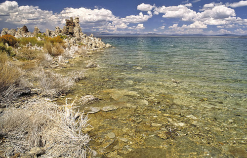
The eerily beautiful Mono Lake actually forms part of a large basin with no outlet to the ocean. This basin originally formed via the actions of geological forces that took place over the past five million years. The lake itself formed approximately 760,000 years ago.
The steady runoff from enormous salt deposits in the region has made this body of water extremely alkaline in nature. The site also continues to remain somewhat geologically active, with the most recent eruption occurring just over 350 years ago.
That eruption further formed another remarkable feature within the lake itself. That’s a small island bearing the name of Paoha Island. But is marvels do not end there, since numerous amazing limestone towers appear all along the perimeter of the incredible lake.
Mono Lake also boasts some impressive physical statistics. Presently, the site covers an area of roughly 70 sq mi (181 sq km). Its maximum depth currently sits at nearly 600 ft (183 m), and the surface sits at an altitude of 6,380 ft (1,945 m) above sea level.
CCL: https://bit.ly/2VnJ6yJ
Mono Lake Location and Ecosystem
The eerily magnificent body of water known as Mono Lake formed in an area of the world already well known for its geological splendor. To the surprise of many, given its unique nature, the lake formed in what now constitutes California, in Mono County.
More precisely, this itself forms a state in the United States, in North America. This fact may surprise many people, given the standard image of that region of the country. However, the area also has some desert regions, one of which serves as home to this site.
Despite being part of a desert environment, Mono Lake serves as home to a thriving ecosystem. Fish cannot live in these waters, but Nature adapts. At the heart of this astonishing system is the presence of a vast population of a diminutive brine shrimp species.
These actually represent an indigenous creature that actually thrives in the lake’s alkaline waters. These tiny crustaceans, which measure about the size of a fingernail, remain inedible to humans. Numerous shorebirds, however, easily and frequently thrive on them.
An enormous volume of microscopic algae also lives in the lake, sometimes creating a dramatic effect. The presence of such a quantity of algae has the unfortunate effect of occasionally turning it bright green in color. The native crustaceans feed on the algae.
The enormous quantities of these invertebrates, numbering as many as six trillion, populate the lake and provide an essential food supply for many shorebirds during their migrations. Each year, as many as two million of them pause at Mono Lake to rest and feed.
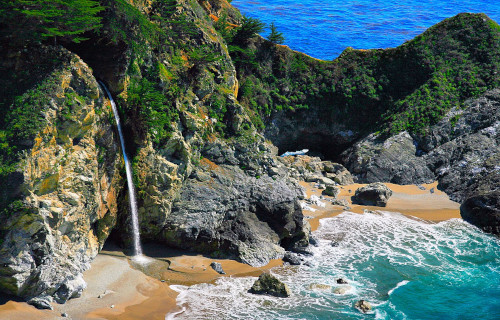
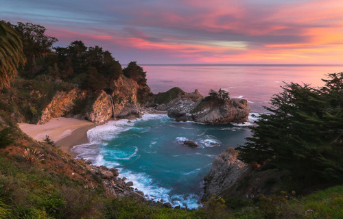
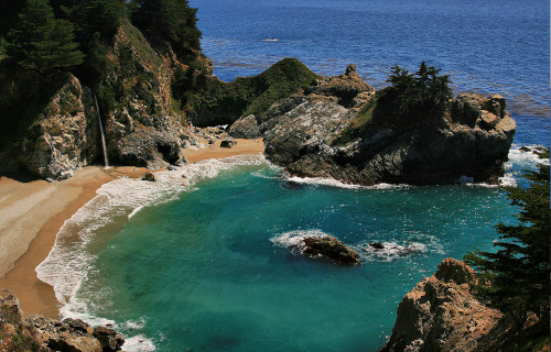
McWay Falls
CCL: https://bit.ly/2XDyRuE
McWay Falls Facts
- The breathtaking McWay Falls appears in the fourth spot in this listing of 7 Magnificent West Coast Marvels only due to random selection.
- This magnificent and secluded natural formation, blessed with so much ethereal beauty, goes by the deceptively simple name used herein. The site’s also a highly fascinating feature, in addition to being one of supreme natural allure and charm.
- Its charm’s enhanced by the fact that until relatively recently, it had slightly different physical characteristics. That’s because, in 1983, natural forces created the actual beach portion of the site, over a comparatively short span of time, where none existed before.
- Fortunately, this incredible site enjoys a great deal of protection from the depredations of man. This holds true due to the fact that it now constitutes part of a legally protected area. In fact, it currently froms an integral part of the Julia Pfeifer Burns State Park.
- Due to the nature of the surrounding terrain, no direct access to the beach itself from the surrounding cliffs exists. The only access is from the sea, which remains barred to the public. An overlook exists, however, that allows vistiors to view its natural splendor.
- In recent years, though, the wonder of McWay Falls garnered it a small place in current culture, more specifically in the annals of modern music. That’s due to the fact that the geological marvel appeared in a recent music video filmed by hip-hop artist, Dr. Dre.
CCL: https://bit.ly/3kmUjwD
McWay Falls Physical Description
Nature did not simply render the stunning McWay Falls so pleasing the eye due to a single aspect of its physical nature, however. That’s because the entire incredible site holds its own appeal, beyond that of the flow of water over the surround cliffs, as amazing as that is.
The cascade itself holds the most attraction, though, for most visitors. This plunges approximately 80 ft (24 m) from the cliffs. The flow itself, furthermore, springs from the similarly-named McWay Creek. It remains a small, gentle flow, under normal circumstances.
Yet its appeal extends to more than the falls themselves. That holds true due to the fact that this gorgeous formation constitutes what’s known as a tidefall. This means that, during at least a portion of each day, the flowing water plunges directly into the ocean!
The next natural marvel to admie about this site is the small, yet lovely, beach that surrounds it. Its exact dimensions vary from year to year, however, due to the actions of the tides. It remains a small, narrow beach, but nevertheless a magnificent one to behold.
At low tide, the always appealing McWay Falls drops directly onto the beach from the cliffs above. During high tide, though, the water reaches to the base of those cliffs, and the flow plunges directly into the surrounding ocean. The effect’s an incredible one.
CCL: https://bit.ly/3zl2ayL
McWay Falls Location, Formation, and History
The location of the awe-inspiring McWay Falls likely comes as no surprise to many people who learn of it. That’s because the site formed in a part of the world already renowned for its natural wonders. In point of fact, it lies in the western portion of North America.
More specifically, though, the site formed in what now constitutes the state of California, in the United States. There, it also lies only about 186 mi (299 km) from the only other tidefall in that part of the region. That other site’s the equally magnificent Alamere Falls.
The exact time frame during which this geological wonder formed, however, remains undetermined with any degree of precision. It’s now known by geologists, though, that the overall geology of the surrounding region formed several hundred million years ago.
At that time, water-borne sediments from a river in what’s now Mexico deposited along the coast. Over great spans of time, this developed into limestone and sandstone. Tectoinc action, furthermore, later compressed this into the geology as it exists today.
It’s currently unknown if the local Indigenous Peoples knew of it, but it’s highly likely. In modern times, though, the first known sighting of it took place by an American homesteader, named Christopher McWay. This fortuitous event occurred in the year 1874.
In 1924, Lathrop Brown and his wife visited and then purchased the land including McWay Falls. When he died, however, his widow donated the land, in 1961. She stipulated, though, that it could only be used as part of the local state park, as its stands today.
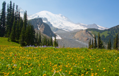
Mount Ranier
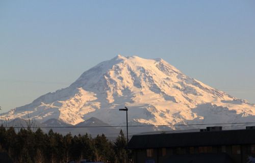
Mount Ranier Facts
- This breathtaking entry into this compendium of 7 Magnificent West Coast Marvels is the looming beauty named Mount Ranier.
- This magnificent natural feature currently bears the name given here. Originally, it bore several other names in the language of the local Native Americans. Those names, used for centuries, consisted of the three terms of Tahoma, Tacoma, and Talol.
- The first known outsiders to view the site did so as part of a surveying mission by Captain George Vancouver, of the British Navy, in 1792. He named it in honor of his friend, Peter Ranier. The Lewis and Clark expedition also saw it between 1804 – 1806.
- This geological marvel further stands out for a variety of reasons. For starters, it ranks as the highest mountain in its portion of the country in which it formed. This behemoth of natural processes also qualifies as the tallest peak in the range in which it sits.
- Its impressiveness doesn’t simply end there, however. That’s because it also ranks as the most topographically prominent mountain in the its immediate part of the globe. It’s also the tallest peak in what now bears the name of Cascade Volcanic Arc.
- That’s right, this site is actually a volcano. In fact, it forms one of 16 volcanoes listed on the Decade Volcano list. The stunning Mount Ranier actually remains a technically active volcano! It’s also considered among the most dangerous on earth.
- The last confirmed activity of the volcano occurred between 1820 – 1854. Given the population of the surrounding region, an estimated 80,000 people are at risk if another eruption occurred. A large scale eruption would also affect other nearby regions.
CCL: https://bit.ly/2U15C2K
Mount Ranier Physical Description
In the minds of most individuals who encounter it, the most notable characteristic of Mount Ranier likely remains its sheer size. This peak possesses a height measuring 14,411 ft (4,392 m) at its highest point. Its sheer height isn’t the only reason the site stands out, though.
That’s due to the nature of the region surrounding it. Relative to the lowest region around it, it stand the highest of any point in its region of the world. It additionally has a proportionately great width, making for an outline that stands out for any who see it.
More precisely, the total area of the base of this majestic formation measures an astonishing 100 sq mi (259 sq km). At its top, however, yet another volcanic feature captures one’s attention. Amazingly, the summit possesses not one, but two incredible craters.
Each of these, furthermore, measures more than 1,000 ft (300 m) in diamter. The one on the eastern side measures slightly larger than the one on the western side. The eastern of the mountain on also slightly overlaps the one formed on the western side of the volcano.
In the western crater, though, yet another feature merits attention. That’s due to the fact that, here, a small crater lake exists. This roughly rectangular measures roughly 130 ft x 30 ft (39.6 m x 9.1 m). It’s shallow, however, only averaging around 16 ft (5 m) in total depth.
Mount Ranier Location, Geology, and Ecology
The breathtaking Mount Ranier formed in a region of the Northern Hemisphere well known for geological activity. In fact, it lies only about 90 mi (145 km) from Mount Saint Helens. More precisely, it sits in the state of Washington, in the United States, in North America.
Its exact location, in fact, further places this remarkable stratovolcano only 54 mi (87 km) southeast of the city of Seattle. Its height, combined with the nature of the local geography, means that in clear weather it’s possible to see it from Portland, Oregon, 135 mi (217 km).
The majority of the mass of this fabulous volcano consists of a combination of debis flows, lava flows, and pyroclastic ejecta. Geological evidence indicates that the mountain began forming roughly 840,000 years ago. Most of its mass now is about 500,000 years old.
Astonishingly, most of its outer surface area has a covering of permanent snowfields and glaciers. Astoundingly, a total of 26 major glaciers presently cover much of the mountain. Due to this, it ranks as the most heavily glaciated site in the continental United States.
Fortunately, the entirety of Mount Ranier lies within the boundaries of the Mount Ranier National Park. The government of the country established this site as its 5th National Park, on March 2, 1899. This therefore provides it with a measure of protection.
The surrounding region thus provides a safe haven for numerous species of flora and fauna. Some of these are not only endemic, but appear nowhere else. The area further possesses a highly diverse ecosystem, due to differing climates at varying altitudes.
Fields surroung the volcano have a gorgeous covering of varied wildflower varities. The region also boasts large forests, some great in age. A vast array of insects and animals also live here, including 65 types of mammals, along with many birds and reptiles.
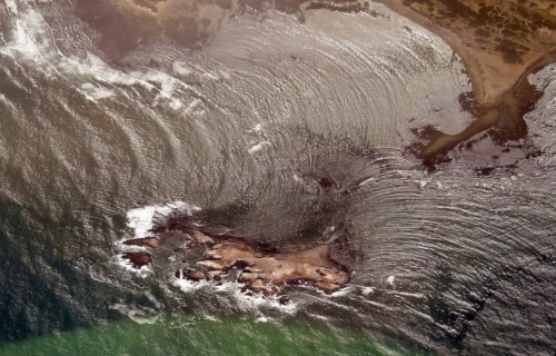
New Years Island
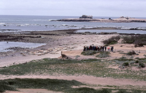
New Year’s Island Facts
- Our next item in this grouping of 7 Magnificent West Coast Marvels holds the celebrated name of New Year’s Island.
- To the great surprise of many people, this small, in some ways unremarkable location actually forms one of several in the world bearing the exact same name. This unusual fact, however, appears to have been entirely coincidental.
- It remains unverified if ancient Native Americans knew of its existence, but remains quite likely. In modern times, the first known sighting of the location took place in 1769, and happened as part of a Spanish expedition exploring the area.
- Despite its extremely tiny and seemingly barren surface area, the site also plays a surprisingly important role in its region. This occurs due to the fact that the spot conveniently serves as an important breeding site for many species of animals.
- The original name for the island, in Spanish, is Ano Nuevo Island. Fortunately for those who value its importance to wildlife, it also now forms part of the Ano Nuevo State Reserve. This luckily provides the local creatures with some protection.
- As part of ongoing efforts to protect New Year’s Island, access to it remains restricted to members of approved research teams. In addition, an ambitious restoration project began in 2010, partly to restore native plants to the site.
CCL: http://bit.ly/2xLZ0ap
New Year’s Island Physical Description
Regardless of its great ecological importance, the surprising New Year’s Island actually only has an extremely tiny total area. In point of fact, this relatively vital, yet little-known location only encompasses an area measuring about 392,000 sq ft, or 9 acres (3.6 ha).
It hasn’t always held this shape, however. Amazingly, up until the 18th century, the island still existed as a peninsula. Over time, though, a channel formed, which eventually resulted in its being separating it from the mainland, where it remains today.
A combination of shale and deposits from ancient dunes primarily makes up the composition of the site known as New Year’s Island. Its exact shape changes slightly quite often, though. Waves pound its soft shoreline, especially during strong storms.
New Year’s Island Location and Ecological Importance
The surprisingly ecologically important New Year’s Island formed in a part of the world already well known for the majesty of its natural formations. More precisely, the wonder sits just off the northern coast of California, in the United States, in North America.
To ensure its protection, the island is also managed under an agreement with the California Department of Parks and Recreation. Somewhat uniquely, perhaps, the actual management is carried out by the California Department of Parks and Recreation.
This admittedly visually unimpressive island nevertheless holds great importance. In fact, it has long served as a vital breeding ground for many animals. In point of fact, some of these rank as Endangered, and breed in few, if any, other locations in the world.
These include northern elephant seals, the endangered Steller Sea Lion, and several species of important seabirds. Due to the presence of so many seals and sea lions, however, Great White Sharks also quite commonly frequent the waters surrounding New Year’s Island.
Ramona Falls
CCL: https://bit.ly/3g1LrqZ
Ramona Falls Facts
- Finishing up this article about these 7 Magnificent West Coast Marvels we give you another gorgeous cascade, named Ramona Falls.
- The breathtaking geological formation known by this simple name remains one of the most beautiful cascades known to man. Part of its extreme beauty comes from the fact that it also has one of the most distinctive appearances of any such formation.
- To many people, this marvel of Nature looks like someone blended a waterfall with the inside of a beehive. Not so coincidentally, the type of remarkable rock formation over which it flows many people know as a honeycomb structure.
- The first reported sighting of this stunningly beautiful waterfall in modern times, amazingly, did not occur until 1933. At that time, a Forest Service employee named John E. Mills came across it and named it. He did this while creating a trail.
- The incredible flow of water that he named Ramona Falls had, however, long been known by local populations of Native Americans. Today, the area may only be accessed via a hike along a rugged trail. This helps account for its being little known.
- Yet, the region in which the wonder of geology lies now forms part of the magnificent Pacific Coast Trail. In fact, the spot also represents the junction of two extremely popular hiking trails. These bear the names the Timberline and the Ramona Falls Trail.
CCL: https://bit.ly/2Vo739a
Ramona Falls Physical Description
The truly breathtaking cascade referred to simply as the Ramon Falls never fails to dazzle those who see it. It does not do so due to seer physical size, though. That’s because this wonder of Nature has a total height that measures approximately 120 ft (37 m).
Yet this frequently overlooked, but nonetheless awesome fall also possesses other, highly respectable, and to some, surprising, statistics. Among these remains the fact that the gorgeous flow of water sits at an elevation that measures 3,560 ft (1,090 m) above sea level.
The staggering beauty of Ramona Falls derives from not simply its height. This only ranks as average, but it has remarkable structure. It’s composition of a series of interlocking, hexagonal-shaped columns creates a multi-layered visual effect that leaves one breathless.
CCL: https://bit.ly/2YC51UR
Ramona Falls Location, Formation, and Nature
The awe-inspiring work of Nature named Ramona Falls formed in a truly picturesque, and somewhat out of the way, part of the world. This geological gem formed on the western side of what’s now known as Mount Hood, in the state of Oregon, in the United States.
More precisely, however, this beautiful cascade also finds itself in an area already so admired for its beauty that it’s garnered federal attention. The waterfall sits within the boundaries of the Mount Hood National Forest, though it remains little known to tourists.
A large component of the great beauty of the site remains the distinctive nature of the rocks over which the water flows. These formed as the result of an ancient volcanic flow, although even volcanologists differ as to exactly when in the past this action occurred.
At the time of the eruption, the flowing lava, largely basaltic in nature, slowly cooled. As it did so, it formed countless vertical hexagonal columns. Erosion later created the distinctive honeycomb pattern, over which the water flows with such beauty now.
The flow of water for the fabulous Ramona Falls itself originates from nearby Mount Hood, although rainfall obviously adds to this flow at times, and in varying amounts. There, the steady process of glacial melt provides a steady stream for a moderate flow.
CCL: https://bit.ly/3kmUjwD
7 Magnificent West Coast Marvels
We hope that each of you thoroughly enjoyed reading, and hopefully learning from, this article we’ve written about these 7 Magnificent West Coast Marvels. It’s also our hope that doing so has left you with either a new or renewed appreciation for such wonders of Nature.
Unfortunately, many other such features around the world now find themselves facing threats to their continued existence in an undamaged state. Many of those dangers, in fact, stem from the actions of mankind. We must do all we can to protect and preserve them all.
Check out our other articles on 3 Geological Masterpieces of Virginia, 5 Beautiful North American Butterflies, 7 Captivating Mammals of Canada, 4 Remarkably Evolved Reptiles