


CCL: https://bit.ly/3yp1319
We hope that you enjoy this article on 8 Geological Wonders of North America. Every part of our world holds an abundance of such beauty, and this area is no exception to that. These come in a incredible variety of types, all wondrous to behold. Of course, these represent only the smallest fraction of the marvels of Nature you can find in this part of the world, or any part, for that matter. But, we hope that these few will serve to whet your appetite for more.
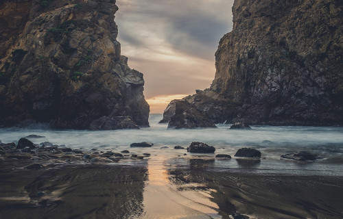
Hells Canyon
Public Domain Image
Hells Canyon Facts
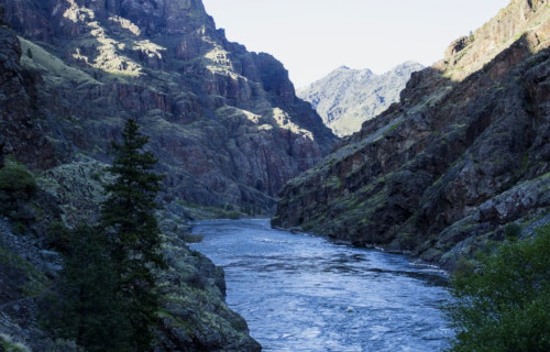
- First up among our choices for inclusion in this article about 8 Geological Wonders of North America comes the awesome Hells Canyon.
- Most notably, the breathtaking site easily remains one of the great marvels of its region. However, and quite surprisingly, to most of the world outside of its region it remains virtually unknown.
- Further, it remains in the shadow of that well-known marvel, the Grand Canyon. However, this amazing site surpasses it in depth. In fact, this ranks as the deepest canyon on its continent.
- It remained unknown to European settlers until 1806. At that time, members of the Lewis and Clark Expedition found the site. However, they turned back before exploring its entirety.
- But, the magnificent gorge had long been known to local Native Americans. Further, several different tribes used the canyon. These included the Nez Perce, Shoshone-Bannock, and the Paiute.
- Finally, today it serves as a locally very popular recreational area. Yet, most of it remains inaccessible by road. It currently serves as a major component of the Hells Canyon National Recreational Area.
Public Domain Image
Hells Canyon Physical Description
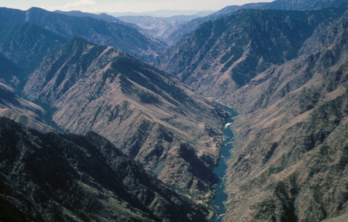
First of all, the sheer grandeur of the mesmerizing Hells Canyon must be taken into account. That’s because it’s sheer dimensions only tell part of its story. However, those remain impressive enough on their own.
Firstly, the magical geological wonder has a truly astounding overall width. That holds true because that measures roughly 10 mi (16 km). Further, its maximum depth measures an astounding 7,993 ft (2,436 m). It also has a total length of about 125 mi (200 km).
Also, the beautiful Snake River flows through the fabulous canyon. Yet, at one point it does so at more than 1 mi (1.6 km) below the western edge. Furthermore, on the other side, majestic mountains soar to a height of 7,400 ft (2,300 m) above it.
Additionally, the awesome site serves as home to an abundance of wildlife. This includes large numbers of black bears, elk, cougar, mountain goats, and deer. Finally, several plant species thrive there that exist nowhere else.
Hells Canyon Location, Formation, and Usage
The sincerely stunning Hells Canyon formed in what now comprises the far northwest section of the United States. This enormous canyon also remains one of the great geological wonders of North America.
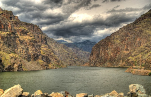
It is located roughly along the borders of three states. These consist of Idaho, Oregon, and Washington. Its earliest formation began around 300 million years ago. This began as the result volcanic activity, not tectonic.
Furthermore, due to ongoing volcanic action, enormous quantities of limestone began to be deposited. Much later, tectonic activity then pushed the limestone, along with sedimentary rock, upward.
In addition, about 6 million years ago, the Snake River formed. Its mighty flow slowly but surely carved out the massive canyon. Then, roughly 15,000 years ago, a massive flood from a melting glacier further expanded it.
Lastly, today the site has several primary uses for mankind. First of all, three large hydroelectric dams have been constructed within its confines. Also, numerous recreational activities happen in abundance within it. These include hiking, boating, fishing, camping, and rafting.
Homestead Caldera
CCL: https://bit.ly/3Aww0Ck
Homestead Caldera Facts
- Next up on this list of 8 Geological Wonders of North America is the magnificent and unique site known as the Homestead Caldera.
- First of all, one fact about the amazing Homestead Caldera stands out among the rest, due to the sheer level of incredulity. That’s the astounding fact that this gorgeous location ranks as perhaps one of the most interesting geological features most of us have never heard of.
- Yet the great majority of local residents know the fabulous feature as simply The Crater, rather than its official name. Both names remain quite deceptive, however. That holds true due to the fact that this marvel of Nature technically qualifies as neither a caldera nor a crater.
- Furthermore, the site also serves as the source of a minor mystery. Settlers and miners first officially discovered the awesome geological wonder in the 19th century. But, it presently remains unknown if Native Americans indigenous to its area ever knew of its existence.
- In addition, the startlingly lovely feature also presently sits on privately owned land. Not surprisingly, however, the current owners of the property subsequently turned the area into a comparatively popular tourist attraction.
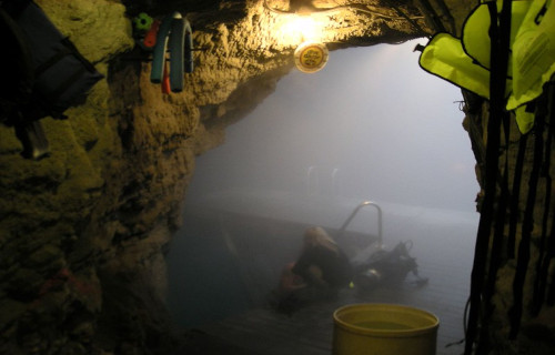
- Finally, this virtually unknown, and quite literally hidden site also holds a singular distinction. That’s because, in addition to everything else, it represents the only warm water destination for scuba diving found on its continent.
CCL: https://bit.ly/3AC3L5s
Homestead Caldera Physical Description
Firstly, geological evidence indicates that Homestead Caldera formed nearly 10,000 years ago. Furthermore, it constitutes only one of many found throughout the region. The impressive dome itself measures roughly 55 ft (16.7 m) in height. That dome also spans roughly 400 ft (122 m) in diameter.
Secondly, the marvelous structure remains mainly composed of limestone, and formed gradually over time. This remarkable formation occurred via the depositing of minerals from the geothermal spring. Subsequently, as a result of internal pressure, the newly-formed dome itself pushed outward.
A relatively small hole in the top of the dome allows sunlight to filter in naturally. Additionally, for tourist purposes, a tunnel was drilled into the side of the dome to allow better access. The geothermal activity also maintains a steady water temperature of between 90-96 F (32-36 C).
CCL: https://bit.ly/3Aww0Ck
Homestead Caldera Location, History, and Nature
Perhaps most notably, the magnificent Homestead Caldera formed near what now constitutes the city of Midway, Utah, in the United States, in North America. To the surprise of many, the magnificent caldera actually represents a geothermal spring contained inside a naturally formed dome.
Additionally, an ongoing archaeological project works to retrieve objects left behind over time by thoughtless humans from the silt. These include coins and antique firearms. Those, and numerous other objects, are retrieved from the silt deposits that line the bottom of the hot spring.
Also, the water found at the site has a typical,and somewhat surprising, depth of nearly 65 ft (19.8 m). Meanwhile the silt itself measures roughly 14 ft (4.3 m) deep in places. This extreme depth makes locating, not to mention retrieving, the various paraphernalia difficult.
Fortunately, however, the owners have committed to every effort to return the site to its natural pristine condition. Those same individuals have also committed to exploring the history surrounding the site, as well.
Purple Sand Beach
CCL: https://bit.ly/3e6VTiL
Purple Sand Beach Facts
- Our third selection for inclusion in this compendium of 8 Geological Wonders of North America is the stunning Purple Sand Beach.
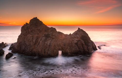
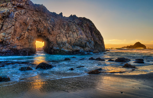
- Perhaps most notably, the incredibly picturesque beach truly ranks as an astonishing sight to see. The magnificent location also bears the alternate name of Pfeiffer Beach, which some people prefer. This gorgeous site derives its name from John Pfeiffer. This family immigrated from France, and represented some of the first settlers in the region.
- However, and perhaps to its benefit, this wonder of geology formed in a rather hard to reach locale. Due to this, although not far from Big Sur, this marvel of geology fortunately remains little-known. This remains a helpful fact, however, as it aids conservation efforts. In fact, not even road signs announce the presence of the site to non-locals.
- Interestingly, the quite unique color of the beautiful beach also appears most noticeable in the winter, after the passing of the seasonal storms. As a result of the effects of these storms, the newly moistened sand glistens in the light like at no other time. This spectacular effect occurs due to the specific mineral composition of the particles forming the beach.
CCL: https://bit.ly/3hhYlVu
Purple Sand Beach Physical Description
First of all, the dazzling and unique Purple Sand Beach actually owes its distinctive color to the nearby mountains. This holds true partly due to the fact that these formed in extremely close proximity to the seashore. This extremely unusual placement represents only the first in a series of factors that created the unique beach.
Secondly, playing yet another part in that chain of factors, these mountains also remain especially rich in mineral deposits. Further, in a most unusual occurrence, the mountains contain vast amounts of the mineral manganese garnet. As you probably guessed, this delicate mineral also forms a purplish-colored silicate.
Thirdly comes the final step in the remarkable process. Local rains wash fine crystals of the mineral down to the nearby seashore. This, therefore, provides a naturally and continually renewing pigmentation of the beach. However, while pure purple predominates, traces of lilac and magenta can also be seen.
Public Domain Image
Purple Sand Beach Location and Geology
Located in North America, the lovely Purple Sand Beach does not merely represent a one-hit wonder of geology. This beach forms part of the Los Padres National Forest, in California, United States. Its brilliantly colored sand, however, is not the only distinctive feature found in this one location.
In addition to the incredible marvel of the beach itself, several marvelous sea caves also appear just along the shoreline. Quite understandably, these natural features remain extremely difficult to access, however. The ocean waves typically remain strong enough to make entering these extremely hazardous.
Additionally, just offshore sits the locally famous Keystone Arch, with a naturally occurring hole near its center. Due to its angle and placement, an incredible coincidence of Nature takes place here. That’s because the setting sun shines directly through the keyhole only during the weeks of the Winter Solstice.
Pewits Nest
CCL: https://bit.ly/3yp1319
Pewits Nest Facts
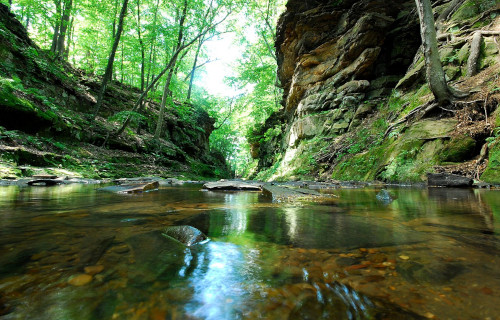
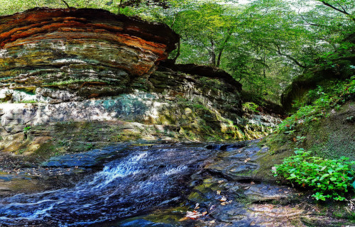
- The next of our choices of 8 Geological Wonders of North America is the truly magnificent site known simply as Pewits Nest.
- Perhaps most notably, the stunning location has one thing in common with some other geological features around the world. That’s because this site ranks as another of those incredible wonders of natural beauty that remain almost unknown outside of its immediate area.
- Furthermore, this area can rightfully make several claims to fame, at least among those who love the beauty of Nature. This statement holds true due to the fact that the location contains remarkably pristine beauty of two kinds. These include magnificent examples of geological, as well as botanical, beauty.
- This fabulous location lies within the confines of the aptly named Pewits Nest State Natural Area. The government created the small Nature Reserve specifically to preserve the natural splendor found there. Its name derives from a species known locally as peewits, which once inhabited the site in abundance.
CCL: https://bit.ly/2V3IEsc
Pewits Nest Physical Description
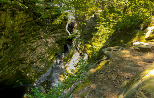
First of all, the Nature Reserve containing Pewits Nest actually only covers a surprisingly small region. That holds true due to the fact that it encompasses a total area of only 9 acres (3.6 hectares). However, the site perfectly proves the old adage that beauty comes in all sizes.
In addition, this awesome wonder of Nature formed across the landscape only about an estimated 10,000 years ago. It must be pointed out that, in geological terms, this makes it quite young. The wondrous site formed through the actions subsequent to the retreat of the last glacier in the region.
That’s because the action carved a narrow, and relatively deep, gorge into the soft and pliable sandstone of the area. The depth of the beautiful gorge ranges across its length. This runs from a depth measuring about 30-40 ft (9.1-12.2 m), not including the height of the several small cliffs which surround it.
In addition, the melting of the glacier also resulted in the creation of multiple small waterfalls, as well. Numerous formations known as potholes also formed, along with a small creek, known locally as Skillets Creek. In fact, this small waterway continues to run through the Reserve even today.
CCL: https://bit.ly/3ytCyju
Pewits Nest Location, Nature, and Preservation
The truly breathtaking Pewits Nest sits in the state of Wisconsin, in the United States, in North America. Further, the state of Wisconsin Department of Natural Resources owns and maintains the site. Its designation as a protected State Natural Area occurred in 1985.
Bountiful and beautiful flora thrives there, perhaps because the location resides within a small dry-mesic forest. The region also consists of rather dense undergrowth and numerous trees. The majority of these consist of white pine, hemlock, red cedar, and yellow birch.
Numerous small animals also such make their home in this magical area. Among others, this includes rabbits, squirrels, and multiple types of birds. Quite sadly, however, the species known as the peewit, from which its name derives, is rarely seen now.
Furthermore, the Pewits Nest State Nature Area remains open to the public. But, quite regrettably, few people outside of the immediate area know of its existence. The parking zone only holds 7-8 cars, since the government makes every effort to maintain the beauty of this small wonder.
However, the officials do not maintain the numerous trails, so visitors to the Nature Reserve must watch their step. Finally, Pewits Nest once contained a small mill, where a water wheel made use of the falls, but no trace of it exists today.
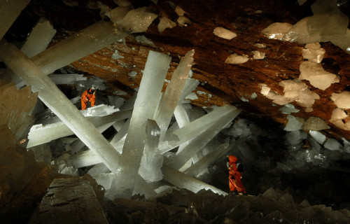
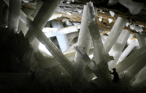
Giant Crystal Cave

CCL: https://bit.ly/1jxQJMa
Giant Crystal Cave Facts
- The fifth of our selections to include in this listing of 8 Geological Wonders of North America is the mind-boggling Giant Crystal Cave.
- Perhaps most notably of all, the term refers to one of the truly fabulous marvels of Nature. In fact, in many ways, this astounding location currently remains one of the most unique of its kind ever discovered. Furthermore, humans discovered this breathtaking place completely by accident, in the year 2000, in the course of mining activities.
- However, the very nature and precise location of the stunning site will forever make it unavailable to the general public. That’s because of its close proximity to a nearby magma chamber. In this, Nature provided this unbelievably unique site with a measure of built-in security from the intrusion of man. Therefore, the very forces that created it continue to protect and preserve it.
- Quite sadly, this fact made it impossible to visit this geologist’s paradise without extremely specialized protective gear. In fact, the temperature and humidity are so high that the heat index is 228 degrees Fahrenheit (105 C). It’s a moot point now, however. After a measure of scientific exploration, the pumps keeping water out of the mine were stopped. The cave then refilled with water, thus preventing further access.
CCL: https://bit.ly/1E6HPMf
Giant Crystal Cave Physical Description
First of all, the incredible Giant Crystal Cave serves as home to the largest crystals on earth. In point of fact, some of these attain a size as great as 34 ft (11 m) long and as estimated weight 55 tons. These monstrously large crystals have a composition primarily consisting of selenite. This mineral, the nearby magma chamber deposited over the course of countless centuries.
Furthermore, these enormous and remarkably impressive crystals formed as a result of an extremely special combination of factors. This process began with greatly heated groundwater being saturated with sulfide ions. Subsequent to this action, significantly colder surface water leaked down and contacted the mineral-saturated hot water. This formed the next step in the process of formation.
However, the two supplies of water did not mix together. This occurred due to the difference in the relative densities of the two separate water supplies. As a result of these unique factors, hydrated sulfates, primarily gypsum, formed at an extremely slow rate over the course of at least 500,000 years. As these crystallized, they formed the enormous crystals present in the cave today.
CCL: https://bit.ly/3wpHjJg
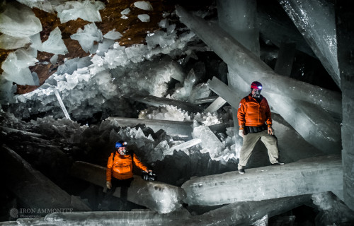
Giant Crystal Cave Location, Condition, and Exploration
The absolutely astounding Giant Crystal Cave formed in a region that now constitutes the area of Chihuahua, Mexico, in North America. In addition, and rather surprisingly to those who discovered it, the cave sits a mere 1000 ft (300 m) beneath the surface. Despite that, it remained unknown until modern times.
But, despite its proximity to the surface, due to the extreme conditions within the remarkable cave, humans still know very little about it. What we do know can be summed up rather briefly. Further, for the moment, no plans exist to explore the cave further, to preserve it in its natural state.
The amazing cave formed in what approximates a roughly horseshoe shape. It also lies within an enormous limestone deposit. Also, faceted crystalline blocks cover the floor, and the enormous crystalline beams protrude through these. This creates incredible patterns, serving to enhance its beauty.
When man originally discovered the cave, water filled the inside. The cave later became accessible only because the nearby mining operation which discovered it kept pumping the water away. Only authorized scientific researchers had access permits, due to the conditions. Finally, experts made the decision to allow the site to flood again, because exposure to air was beginning to erode the crystals.
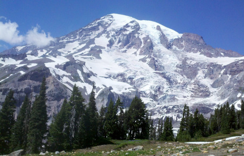
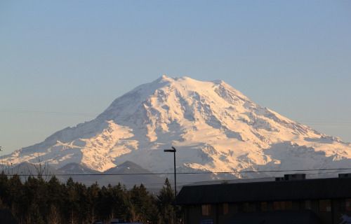
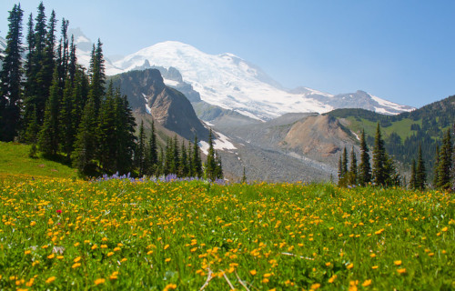
Mount Ranier
Mount Ranier Facts
- Coming up next in this article about 8 Geological Wonders of North America is the astounding site known simply as Mount Ranier.
- This magnificent natural feature currently bears the name of Mount Ranier. Originally, it bore several other names in the language of the local Native Americans. Those names, used for centuries, consisted of the three terms of Tahoma, Tacoma, and Talol.
- The first known outsiders to view the site did so as part of a surveying mission by Captain George Vancouver, of the British Navy, in 1792. He named it in honor of his friend, Peter Ranier. The Lewis and Clark expedition also saw it between 1804 – 1806.
- This geological marvel further stands out for a variety of reasons. For starters, it ranks as the highest mountain in its portion of the country in which it formed. This behemoth of natural processes also qualifies as the tallest peak in the range in which it sits.
- Its impressiveness doesn’t simply end there, however. That’s because it also ranks as the most topographically prominent mountain in the its immediate part of the globe. It’s also the tallest peak in what now bears the name of Cascade Volcanic Arc.
- That’s right, this site is actually a volcano. In fact, it forms one of 16 volcanoes listed on the Decade Volcano list. The stunning Mount Ranier actually remains a technically active volcano! It’s also considered among the most dangerous on earth.
- The last confirmed activity of the volcano occurred between 1820 – 1854. Given the population of the surrounding region, an estimated 80,000 people are at risk if another eruption occurred. A large scale eruption would also affect other nearby regions.
Mount Ranier Physical Description
In the minds of most individuals who encounter it, the most notable characteristic of Mount Ranier likely remains its sheer size. This peak possesses a height measuring 14,411 ft (4,392 m) at its highest point. Its sheer height isn’t the only reason the site stands out, though.
That’s due to the nature of the region surrounding it. Relative to the lowest region around it, it stand the highest of any point in its region of the world. It additionally has a proportionately great width, making for an outline that stands out for any who see it.
More precisely, the total area of the base of this majestic formation measures an astonishing 100 sq mi (259 sq km). At its top, however, yet another volcanic feature captures one’s attention. Amazingly, the summit possesses not one, but two incredible craters.
Each of these, furthermore, measures more than 1,000 ft (300 m) in diamter. The one on the eastern side measures slightly larger than the one on the western side. The eastern of the mountain on also slightly overlaps the one formed on the western side of the volcano.
In the western crater, though, yet another feature merits attention. That’s due to the fact that, here, a small crater lake exists. This roughly rectangular measures roughly 130 ft x 30 ft (39.6 m x 9.1 m). It’s shallow, however, only averaging around 16 ft (5 m) in total depth.
CCL: https://bit.ly/2U15C2K
Mount Ranier Location, Geology, and Ecology
The breathtaking Mount Ranier formed in a region of the Northern Hemisphere well known for geological activity. In fact, it lies only about 90 mi (145 km) from Mount Saint Helens. More precisely, it sits in the state of Washington, in the United States, in North America.
Its exact location, in fact, further places this remarkable stratovolcano only 54 mi (87 km) southeast of the city of Seattle. Its height, combined with the nature of the local geography, means that in clear weather it’s possible to see it from Portland, Oregon, 135 mi (217 km).
The majority of the mass of this fabulous volcano consists of a combination of debis flows, lava flows, and pyroclastic ejecta. Geological evidence indicates that the mountain began forming roughly 840,000 years ago. Most of its mass now is about 500,000 years old.
Astonishingly, most of its outer surface area has a covering of permanent snowfields and glaciers. Astoundingly, a total of 26 major glaciers presently cover much of the mountain. Due to this, it ranks as the most heavily glaciated site in the continental United States.
Fortunately, the entirety of Mount Ranier lies within the boundaries of the Mount Ranier National Park. The government of the country established this site as its 5th National Park, on March 2, 1899. This therefore provides it with a measure of protection.
The surrounding region thus provides a safe haven for numerous species of flora and fauna. Some of these are not only endemic, but appear nowhere else. The area further possesses a highly diverse ecosystem, due to differing climates at varying altitudes.
Fields surroung the volcano have a gorgeous covering of varied wildflower varities. The region also boasts large forests, some great in age. A vast array of insects and animals also live here, including 65 types of mammals, along with many birds and reptiles.
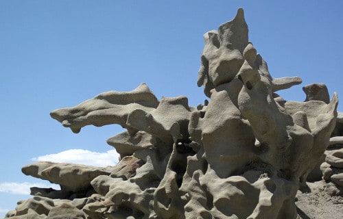
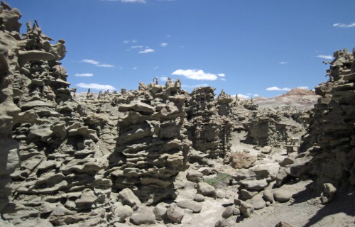
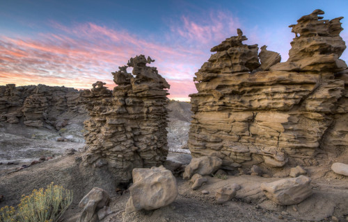
Fantasy Canyon
CCL: http://bit.ly/2xQPH8p
Fantasy Canyon Facts
- Placing seventh out our choices of 8 Geological Wonders of North America, though only due to random selection, is the gorgeous Fantasy Canyon.
- Most notably, if ever any place found on Earth had an appropriate name, the absolutely incredible Fantasy Canyon must be it. In addition to its own magnificent beauty, this truly astonishing geological masterpiece also remains quite isolated. That’s because the gorgeous canyon formed in what now represents a remote and rather rugged section of North America.
- Additionally, the stunning location also remains popular for the extraordinary geologic marvels present there. Many individuals further believe that these represent some of the most unique on Earth. Furthermore, the Bureau of Land Management in the area it lies in protects this small in area, but truly unique place, to preserve its pristine beauty for the future.
- The breathtaking beauty of the canyon continues to be extremely fragile, however. As a result, it now, therefore, occasionally goes by the alternate name of Nature’s China Shop. However, its official discovery occurred relatively recently, in the year 1909. The paleontologist Earl Douglass became the first known person to document this site. Native Americans likely knew of its existence, but no records exist.
CCL: http://bit.ly/2xQPH8p
Fantasy Canyon Physical Description
Firstly, the astounding rock formations found throughout the aptly-named Fantasy Canyon originally deposited during the late portions of the Eocene Epoch. This amazing action occurred between 38-50 million years ago. However, the extraordinary features of the canyon, contained within a scant 10 acres (4.6 hectares), do not constitute its only claim to distinction.
Furthermore, the subsequent erosion eventually led to the creation of the incredible features present today. However, this happened in conjunction with the particular composition of the rocks themselves. Furthermore, horizontal mineral deposits also run through the rock formations, with actually two different mineral veins present.
In addition, one of these two veins of mineral deposits consists of Gilsonite. This is a fascinating mineral based on hydrocarbons. The other vein remains comprised of magnetite, which forms a mineral containing unique magnetic properties. Therefore, the site remains distinctive for its composition, as well as its remarkable appearance.
Public Domain Image
Fantasy Canyon Location and Uniqueness
Most notably, the utterly astounding Fantasy Canyon formed in what now constitutes northeast Utah, in the United States. Also, the region in which the canyon formed originally bordered an ancient lake. This body of water therefore served as the original source of the sandstone in the area.
Further, ongoing sedimentation over the passage of time deposited various other minerals and material in the region. These primarily include sandstone, siltstone, and shale. These various minerals erode at different rates, however. But, the sandstone appears to be much more durable than the others.
Also, as the other deposited minerals eroded, the unique features of Fantasy Canyon developed. These have been further augmented by wind erosion over the ensuing millions of years. To top things off, the canyon also serves as home to an extensive number of fossils, dating back to the Eocene Epoch.
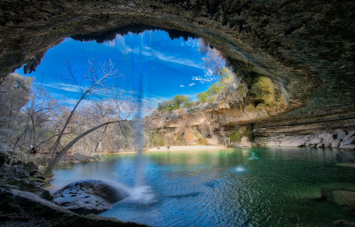
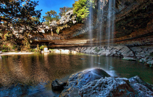
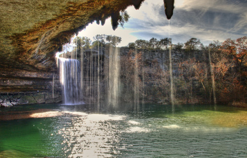
Hamilton Pool
Public Domain Image
Hamilton Pool Facts
- The last of our picks for 8 Geological Wonders of North America is the incredibly picturesque site known as the Hamilton Pool.
- Firstly, the truly breathtaking site known as Hamilton Pool ranks as another one of those rather incredible geological marvels. That’s because, like some others, the gorgeous site still remains virtually unknown outside of its own immediate area. However, it forms a popular destination for tourists who come to its area and then accidentally discover it.
- However, two Native American tribes, the Lipan and the Tonkawa, of the Apache Nation, previously utilized the site until the 19th century. But, the fabulous site then passed to the Hamilton family, who purchased it in the 1860’s, after the departure of the tribes. The family owned it until they decided to sell it to the state in the late 20th century.
- This incredible site also now serves as the cornerstone of the marvelously scenic Hamilton Pool Preserve. This legally protected area the state later established in the year 1985. Furthermore, the entire Preserve further constitutes a small but gorgeous protected area that covers roughly 232 acres (93.9 ha). This has allowed for an ongoing restoration of the local ecosystem.
CCL: https://bit.ly/3dRfOC1
Hamilton Pool Physical Description
First of all, the magnificent Hamilton Pool remains rather unique in several ways. The water of the awesome site comes from a small waterfall which steadily feeds and maintains the popular pool. Furthermore, this small but nonetheless picturesque waterfall plunges a total of about 50 ft (15.2 m).
Yet that is not the only remarkable trait of this fabulous geological marvel. That holds true due to the fact that the waterfall never completely dries up. But, it does slow to a trickle at times, due to various factors. As a result of this, the dimensions of the pool vary greatly. However, in terms of depth, the pool stays quite shallow.
The surrounding rocks are composed of limestone, and the natural filtering action keeps the water a jade green. The pool even remains surrounded by numerous large limestone slabs. And last but not least, numerous stalactites can even be seen hanging from the ceiling of the underground portion.
CCL: https://bit.ly/3dTcUfV
Hamilton Pool Location, Formation, and Ecology
It must be noted that the stunning marvel that we call the Hamilton Pool, with its picturesque beauty sits about 23 mi (37 km) west of Austin, Texas, in the United States. Its beauty stands out among the otherwise relatively harsh nature of its surroundings in this portion of North America.
Geologists remain uncertain when Hamilton Pool formed, yet believe it happened at least 10,000 years ago. But, its formation occurred due to the forces of erosion, working over a vast span of time. In addition, the dome covering an underground river collapsed at that time, forming the grotto.
Also, the waters of the breathtaking pool eventually flow into the mighty Colorado River. This area forms a small oasis in the region and, as a result, teems with flora and fauna. The stone overhang stays covered in dark green moss, and the banks teem with mountain juniper and various small shrubs.
Not only that, but several rare bird species also make their home around the pond. Officials allow public swimming, yet carefully monitor the activity since they do not artificially maintain the water quality. As a result, the site occasionally closes to public swimming, for public safety.
Public Domain Image
8 Geological Wonders of North America
We sincerely hope that you have thoroughly enjoyed reading and learning about these 8 Geological Wonders of North America. Countless others await your discovery among our other articles. We invite you to peruse them at your leisure, and share them with your friends for all to enjoy. But many of these marvels are in need of our help. They must be preserved for future generations to enjoy them as well. To that end, let us all do everything we can to ensure their preservation.
Check out our other articles on 8 Truly Monumental Orchids, 7 Wondrous Wasps Worldwide, Spectacular Dolphins Throughout Our World, 9 Bewildering African Plants