


CCL: http://bit.ly/2GGxvUT
We sincerely hope that you enjoy this article about 8 South American Geological Marvels. Every part of the world has been blessed by Nature with such wonders, to be certain. This region is no exception, as you will see as you read on. However, it must be pointed out that these represent only a handful of the splendors of Nature that you can find in this region. Further, since such things are entirely subjective, you may know of other features you would place on such a list. If so, we invite you to tell us about them.
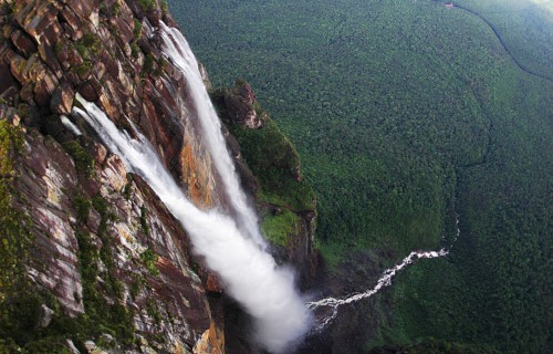
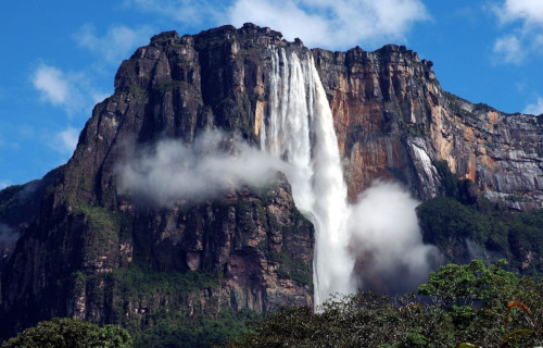
Angel Falls

CCL: https://bit.ly/1E6HPMf
Angel Falls Facts
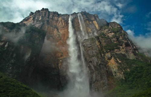
- It seems only right that this feature, the mind-boggling Angel Falls, lead off our list of 8 South American Geological Marvels.
- Firstly, Angel Falls is a magnificent waterfall in Venezuela, in South America. It also forms the highest uninterrupted waterfall on earth. It actually measures roughly 19 times higher than the Niagara Falls.
- Further, it boasts a height of 3,212 ft. (979 m) and an incredible plunge of 2,648 ft (807 m). Angel Falls also drops over the edge of the Auyantepui mountain in the Canaima National Park.
- The height figure consists only partly of the main plunge. It also includes about 1,300 ft (400 m) of sloped cascades and rapids below the drop. But it also includes as a 98 ft (30 m) high plunge downstream of the talus rapids.
- In addition, it now constitutes a UNESCO World Heritage Site, in the Gran Sabana region of Bolivar State.
Angel Falls Discovery
Most notably, the breathtaking Angel Falls formed as part of the Gauja River. This also flows into the Churun River, a tributary of the Carrao River. The waterfall has been known as the Angel Falls since the mid-twentieth century.
That’s because a United States aviator, Jimmie Angel, was the first person to fly over the falls. Consequently, per his request following his death, Angel’s ashes were scattered over the falls on July 2, 1960.
During a return flight on 9 October 1937, Angel tried to land his monoplane atop Auyan-tepui. However, the plane was damaged when the wheels sank into the marshy ground. Angel and his three companions, including his wife Marie, were forced to descend the tepui on foot.
Finally, it took them 11 days to make their way back to civilization via the gradually sloping backside. But, news of their adventure spread and the waterfall was subsequently named Angel Falls in his honor.
Angel Falls Scaling
The official height of the staggering Angel Falls was determined by a survey carried out by a later expedition. American journalist Ruth Robertson financed the trek, which occurred on 13 May 1949.
Also, the first known attempt to climb the face of the cliff was made in 1968 during the wet season. It failed because of slippery rock.
But, in 1969 a second attempt was made during the dry season. This attempt failed due to a lack of water and an overhang 400 ft (120 m) from the summit.
Finally, the first successful climb to the top of the cliff occurred on January 13, 1971. The intrepid climbers required nine and a half days to ascend and one and a half days to rappel down.
Cano Cristales
CCL: https://bit.ly/3xaDNnk
Cano Cristales Facts
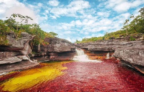
- The second of these 8 South American Geological Marvels is the kaleidoscopic flowing beauty known as Cano Cristales.
- Its mesmerizing beauty always enchants all who encounter its extraordinary scenery. This occurs due to a unique and breathtaking combination of geological and botanical factors.
- Many people also often refer to it by the names Liquid Rainbow and the River of Five Colors. As a result, many individuals consider Cano Cristales to be the most beautiful river on earth.
- This opinion comes, firstly, as a result of the fact that the river presents five separate colors. However, for about half of the year, only four of the gorgeous colors appear visible.
- Finally, during the other half of the year, the fifth color appears as well. This, therefore, completes the transformation. The colors presented include green, yellow, blue, black, and red.
Cano Cristales Unique Characteristics
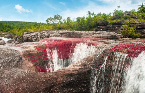
First of all, much of the riverbed of Cano Cristales formed covered with rocks composed of quartzite. These rocks form the source of the four colors present in the river year round.
Further, the stones originated with the Serraina de la Macarenia tableland. This formation is also around 1.2 billion years old. Because of this, these comprise some of the oldest exposed rocks known to man.
Additionally, Cano Cristales represents an extremely fast flowing river and possesses numerous waterfalls and rapids. Nature also carved many deep cavities in the geology of the river bed.
CCL: https://bit.ly/3xbS2s6
Cano Cristales Flora and Fauna
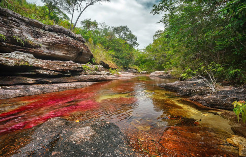
Most notably, the truly extraordinary river named Cano Cristales formed in a rather remote region. That area consists of the country of Colombia. This unique river remains located in the province of Meta.
Furthermore, this magnificent site has a border composed of three rather large ecosystems. In fact, these consist of the Eastern Llanos, the Andes, and also the amazing Amazon rainforest.
Each of these also contributes its own high diversity of flora and fauna to the river. One of these serves as the source of the fifth color in the river. This is due to the aquatic plant Macarenia clavigera. It blooms in vast quantities on the rocks on the riverbed and grows bright red in color.
Finally, the predominant biome of Cano Cristales equals a hydrophytic rainforest. The surrounding region serves as home to 420 known species of birds, 43 species of reptiles, 8 primates, and 420 avian species.
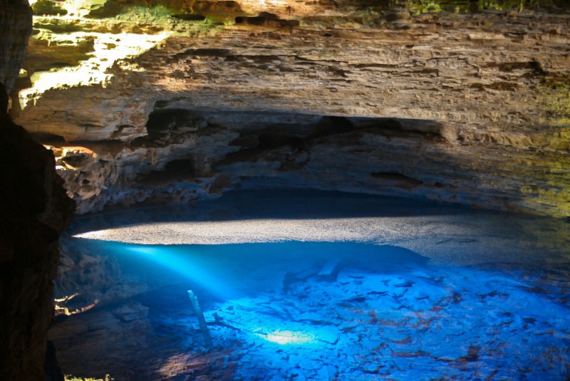
Enchanted Well

CCL: http://bit.ly/2xQPH8p
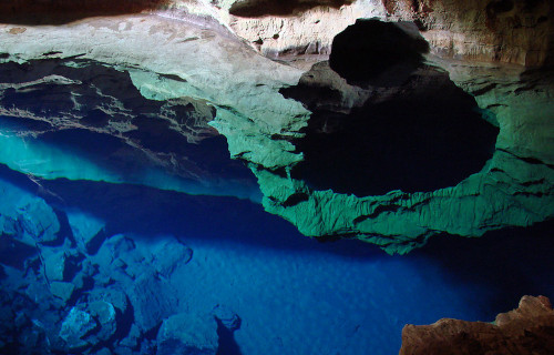
Enchanted Well Facts
- Placing third in this compendium of 8 South America Geological Marvels is the heavenly Enchanted Well, though only by random listing.
- Most notably, the appropriately named site truly merits its name. That’s because this marvelous site represents a breathtakingly beautiful site of geological awe and wonder
- Furthermore, this incredible geological feature formed in a rather remote part of the world. Coincidentally, by pure chance, the area in which it formed also happens to lie very close to a protected area.
- Due to its remarkable characteristics, roughly 7,000 visitors tour the Enchanted Well each year. However, the ecosystem of which it forms part remains quite fragile. Thankfully though, preservation efforts are in place
- Finally, this astonishing site has yet another fact to make it worthy of appreciation. It also continues to serve as home to a wide variety of animal life indigenous to the region.
CCL: https://bit.ly/3dxKCaB
Enchanted Well Physical Description
First of all, the seemingly magical Enchanted Well sits inside the sheltering confines of a moderately large limestone cave. Yet, its placement allows for adequate light to enter.
Further, the incredibly picturesque water of the well remains surprisingly deep. As a result, it has an average depth of roughly 197 ft (60 m). However, it also has a width of about 361 ft (110 m) at its widest.
But, the placement of the Enchanted Well isn’t its only claim to fame, by any means. Its water also remains world-renowned for its extraordinary clarity. This astounding characteristic occurs due to the presence of magnesium.
Because of the presence of the mineral in the water, the pool has almost unbelievable clearness. Therefore, its clarity remains so great that a visitor can see all the way to the bottom of the pool.
CCL: http://bit.ly/2xQPH8p
Enchanted Well Location, Formation, and Ecosystem
First, the astounding Enchanted Well formed in the eastern portion of the country of Brazil . Fortunately, the extreme ruggedness of the region, and also its relative inaccessibility, helps to limit tourism.
Luckily, natural forces created it within what now constitutes the boundaries of the Chapada Diamantina National Park.
In addition, this incredible site actually formed through the slow but relentless effects of erosion. This occurred because of the existence of an underground river within its surrounding limestone.
Further, Nature even provided just the right combination of factors to allow for its appreciation. A fortuitously placed natural opening allows sunlight to enter. Additionally, the light enters at just the right angle to create a stunning blue hue.
In addition to being blessed with great beauty, countless creatures native to the region call the site home. This includes numerous species of bats, along with a few frogs and snakes, all dependent on its ecosystem.
Finally, it also serves as one of only a few known locations where a rare species of blind catfish lives.
Lake Titicaca
CCL: https://bit.ly/1E6HPMf
Lake Titicaca Facts
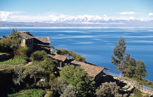
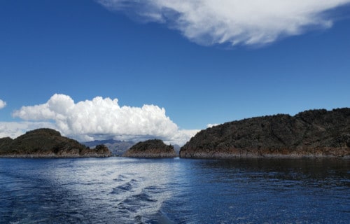
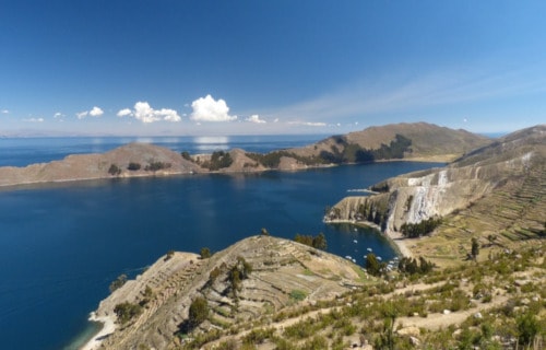
- Listing next out of these 8 South American Geological Marvels is the supremely impressive Lake Titicaca.
- First of all, this term serves as the name of a rather large lake. The stunning sight formed in the Andes mountains. The lake also lies on the borders of the countries of Peru and Bolivia.
- In regards to volume, it forms the largest lake in all of South America. Furthermore, it also comprises two sub-basins, joined by a strait.
- One basin has a maximum measured depth of about 932 ft (284 m). The other basin, however, remains much shallower. As a result, it has a deepest measured depth of only 131 ft (40 m).
- In addition, five major rivers flow into Lake Titicaca, along with twenty smaller streams. The lake also serves as home to 41 islands, and some of these remain densely populated.
- Finally, the water of the lake typically remains surprisingly cold. This occurs as a result of its sources, and also to the presence of near-constant high winds. Because of these factors, its temperature averages only 50 F (10 C).
CCL: https://bit.ly/1iowB8m
Lake Titicaca Geology
Perhaps most notably, gorgeous lake Titicaca lies within the Tinajani Basin. Further, this itself also forms part of a large intermontane basin. This feature originally formed between 27-20 million years ago.
Firstly, the magnificent site has a maximum length of roughly 118 mi (190 km). Secondly, its maximum width measures 50 mi (80 km). The total surface area equals around 3,232 sq mi (8.372 sq km). The surface of this geological marvel also sits at an altitude of 12, 507 ft (3,812 m).
Quite unfortunately, since 2000, the levels of the lake have been steadily receding. Receding glaciers and shortened rainy seasons, appear to be the leading culprits in this trend. These may be occurring due to climate change.
CCL: https://bit.ly/1E6HPMf
Lake Titicaca Climate and Ecology
Lake Titicaca possesses a rather strong alpine climate. The temperature stays cool to cold throughout the year. The average rainfall totals about 24 in (610 mm).
The lake itself remains home to more than 530 aquatic species. Large numbers of waterbirds also call the lake home. Lake Titicaca was designated a Ramsar Site in 1998. There are several animal species present that exist nowhere else on earth.
Numerous endemic species of fish also live in the lake. There are also several unidentified species of bivalves present in the lake. These are currently being studied as potentially previously unknown species.
Salar de Uyuni
CCL: https://bit.ly/1ryPA8o
Salar de Uyuni Facts
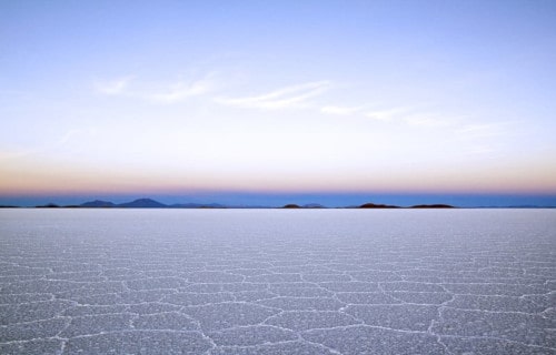
- The fifth of our 8 South American Geological Marvels is one of the most unusual places on earth, the incredible Salar de Uyuni.
- Most notably, the mind-blowing location easily ranks as the largest known salt flat on earth. But that isn’t all, since it also formed in an unbelievably remote and difficult to reach location
- Furthermore, the entire location remains exceedingly smooth and flat over the entire expanse. Because of this, the site is often actually used as a means of calibrating the altimeters aboard various satellites
- In addition, a remarkable transformation occurs after a period of rain. This results in an extremely thin and nearly perfectly calm layer of water. That transforms the site into what serves as the largest mirror on earth.
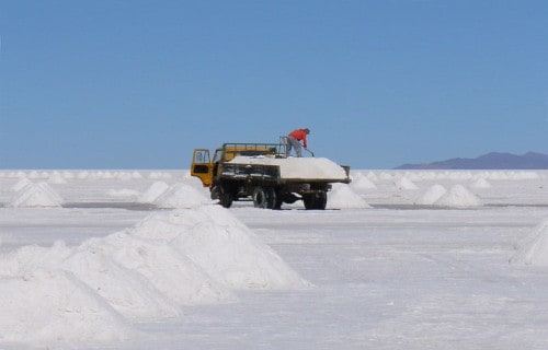
- Finally, in addition to the vast salt reserves, it also holds another valuable resource. That’s because Salar de Uyuni holds roughly 40% of the known reserves of lithium in the entire world.
CCL: https://bit.ly/1ryPA8o
Salar de Uyuni Physical Description
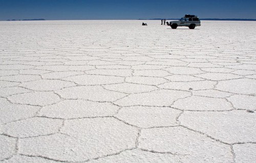
Firstly, the sheer size of the astonishing Salar de Uyuni must be put into perspective. The incredible site covers an astounding area of roughly 4,086 sq mi ((10,582 sq km). In comparison, that’s larger than 37 of the countries in the world.
Yet that hardly serves as the only wondrous thing about the site. First of all, the layer of salt actually has an average depth of more than 6 ft (2 m). In addition, it remains so smooth that the surface height does not vary by more than 3 ft (1 m).
Finally, its mineralogical wealth does not end at salt and lithium. Because of its unique nature, it also contains large quantities of other minerals. These valuable resources include potassium, magnesium, and borax.
CCL: https://bit.ly/1E6HPMf
Salar de Uyuni Location, Formation, and Geology
The visually staggering Salar de Uyuni formed in a rather rugged and remote location. That’s because the fabulous wonder of Nature formed in one of the highest sections of the Andes Mountains.
Further, it sits in the country of Bolivia, at an altitude of 11,995 ft (3,656 m) above sea level. Additionally, it formed during the uplift of the mountains, as several ancient lakes were transformed.
Furthermore, scientists estimate that this process began between 30,000 – 42,000 years ago. Between that time and roughly 11,500 years ago, several other lakes also formed and then eventually evaporated.
Finally, and amazingly, the central area holds yet another surprise. In that areas, several small islands actually appear. These represent the tops of ancient volcanoes, and also a source of numerous fossils.
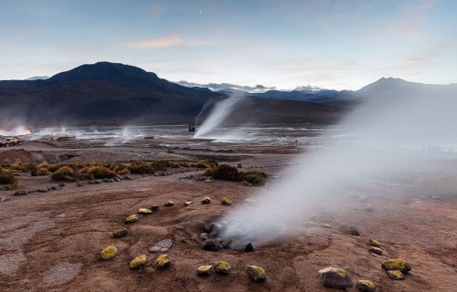
El Tatio
CCL: http://bit.ly/2GGxvUT
El Tatio Facts
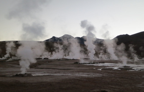
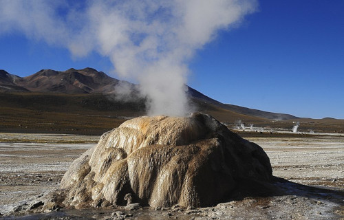
- The next of the 8 South American Geological Marvels on this list is the site whose landscape is hard to believe exists, El Tatio.
- The quite incredible location forms an extensive, highly active geyser field. This marvel of geology also sits at a high elevation, within the snow-capped Andes Mountains.
- Located in the northern section of Chile, El Tatio sits at an altitude of roughly 14, 173 ft (4,320 m). In terms of location, this makes it one of the highest situated such fields known to man.
- The name itself means grandfather, and the location also ranks as rather remote. Further, the nearest sizable population center remains about 55 mi (89 km) away.
- Visiting the site can also be dangerous, however, due to conditions. Further, on occasion, the fragile crust surrounding the geysers gives way beneath the weight of an individual.
El Tatio Landscape and Geyser Activity
El Tatio is also surrounded on all sides by the enormous mountains of the Andes. The geyser field boasts more than 80 active geysers. By number, this makes it the largest such field in the Southern Hemisphere. However, two larger fields exist in the Northern Hemisphere.
The majority of the individual geysers measure relatively small, in terms of elevation of the eruption. The average height of the geysers in El Tatio is about 29.5 in (0.75 m ). The most powerful individual geyser averages only 19.7 ft(6 m) in height.
CCL: https://bit.ly/3yhOR25
El Tatio Geothermal Activity
Geysers do not comprise the only geothermal activity that El Tatio remains known for, however. More than 100 steam fumaroles also exist within the area. The majority of these stay continuously active.
The contrast between the steam and the frigid air at the field’s altitude makes for a striking image. Visitors also find several large geothermal pools in the area.
The water within these contains a variety of minerals. These pools remain an almost constant 95F (35C) in temperature. Countless bubbling mud pots also fill the region. Both the mineral pools and the mud pots appear to be popular tourist attractions.
Boiling Lake
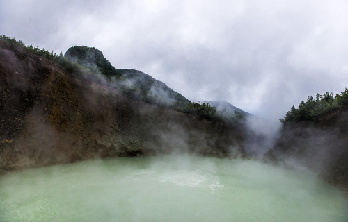
Photo: Göran Höglund (Kartläsarn)
CCL: https://bit.ly/3w716Nr
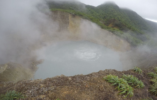
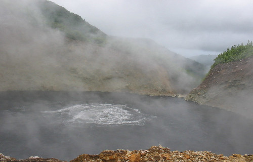
Boiling Lake Facts
- As the next to last of our selection of 8 South American Geological Marvels, the awesome Boiling Lake quite literally heats up the list.
- The most noteworthy fact about the natural wonder remains its status as the second-largest hot lake in the world. In addition, it itself forms part of the Morne Trois Pitons National Park, which is a World Heritage Site.
- The first ever recorded sighting of this geological marvel was in 1870, by Edmund Watt and Henry Nicholls. Also, the first scientific investigation of the site was carried out in 1875.
- Not only is it extremely unique, but its location also ranks as somewhat remote. The nearest road sits about 8.1 mi (13 km) from the site, thus access remains limited.
- Interestingly, the site stays active, so will occasionally drain, and even form geyser-like fountains of hot water and steam. Occasionally, it will even empty and refill in only a single day.
CCL: https://bit.ly/3jyrTjk
Boiling Lake Physical Description
Firstly, the dimensions of the Boiling Lake remain constantly variable, depending upon conditions. Typically mild phreatic eruptions in the region occur periodically and dramatically affect the level of the small lake.
However, its diameter averages between 200-250 ft (61-76 m) across. The depth of the lake naturally also varies, yet an average depth has been determined to be about 195 ft (59 m).
The color of the water also varies, including becoming green, yet usually, ranges from grayish-blue to bright blue. In addition, the temperature of Boiling Lake ranges between 180-197 F (82-92 C).
This flooded fumarole sits amid jagged outcroppings of rock, which average approximately 100 ft (30 m) in height. Besides to the ever-present steam, the site will occasionally spew forth various noxious gases as well.
CCL: https://bit.ly/3qFeVl7
Boiling Lake Location and Formation
The beautiful yet dangerous Boiling Lake sits about 6.5 mi (10.5 km) east of the town of Roseau, Dominica, near South America. Consequently, the site not only has the distinction of being remote, but the surrounding terrain also presents rugged conditions.
The water originates from plentiful rainfall and two small streams that flow into the site. As a result, the water becomes super-heated by proximity to the underlying magma chamber.
Various combinations of minerals in the water create the color, which varies, yet generally remains either bluish gray or bright blue.
Being rather porous in nature, the surrounding rocks also allow the water to escape rapidly when the nearby volcanic activity interrupts the regular inflow.
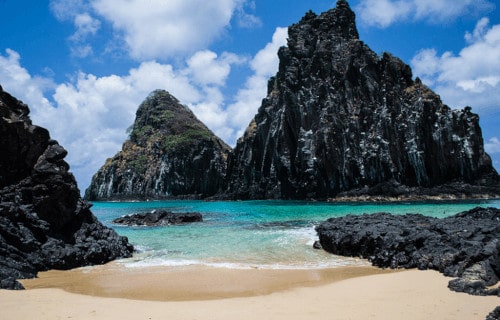
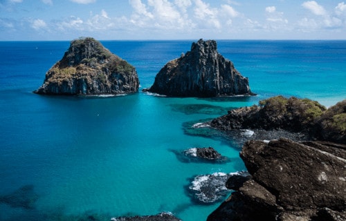
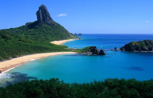
Fernando de Noronha
CCL: https://bit.ly/1p2b8Ke
Fernando de Noronha Facts
- Last, but absolutely not least, among our 8 South American Geological Marvels is the scintillating beauty of Fernando de Noronha.
- Most notably, this astounding site is a small archipelago situated in the Atlantic Ocean. Furthermore, it lies roughly 220 mi (354 km) off the coast of Brazil.
- The archipelago consists of 21 islands and islets. Additionally, the principal island has an area of 7.1 sq mi (18.4 sq km). The total area of all islands and islets is about 10 sq mi (26 sq km).
- The permanent population of Fernando de Noronha is less than 3,000 individuals. Since 2001, UNESCO has listed the location as a World Heritage Site as well. This occurred due to the importance of the unique environment of this marvel of geology.
CCL: https://bit.ly/1p2b8Ke
Fernando de Noronha Geology and Climate
Firstly, all components of Fernando de Noronha remain quite unique. That’s because these are the uppermost portions of an underwater mountain range. Further, the islands and islets all have a volcanic origin.
The base of this large volcanic formation also lies roughly 2,480 ft (756 m) beneath the surface of the ocean. In addition, the highest elevation of the archipelago lies at 1,060 ft (323 m).
The climate also has a primarily tropical nature. The temperature actually varies very little, either between day and night, or month to month. Additionally, it only has two seasons, rainy and dry.
CCL: https://bit.ly/1ryPA8o
Fernando de Noronha Flora and Fauna
Perhaps most notably, the archipelago of Fernando de Noronha is home to a diverse number of plant and animal species. Furthermore, many of these exist nowhere else. At least 15 endemic species of plants fit that description.
For example, the animals living only on this archipelago include three species of birds and two reptilians. But, a native rodent species once existed. However, it has now become extinct.
Finally, the islands and islets remain famous for a specific reason. That’s due to the beauty, variety, and quantity of marine life in the local waters. This include dolphins, sea turtles, and also albatrosses.
CCL: http://bit.ly/2xQPH8p
We truly hope that you have enjoyed this article on 8 South American Geological Marvels. We have certainly enjoyed creating and presenting it to you, our readers. Obviously, such marvels exist in all parts of the world, to be certain. We encourage you to explore those with us as well. But, this region has its equal share of them, too. All deserve our appreciation, often inspiring awe and wonder at the splendor of Nature at its finest. But, it remains up to us to protect and preserve for our posterity.
Check out our other articles on North American Gulches and Canyons, 6 Incredible Asian Islands, 5 Marvels of New Zealand and Australia, 7 Spellbinding African Marvels