


We hope that you enjoy this article on Earth’s Geothermal Marvels. These are some of the most incredible sites and locations in the world. The internal forces which drive our world often create locations of wondrous beauty. Although sometimes dangerous, their beauty cannot be denied and should be appreciated. Herein we present to you a selection of such marvels for your appreciation and enjoyment.
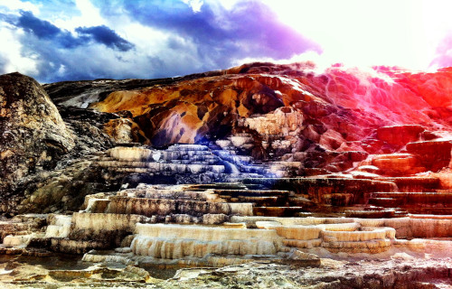
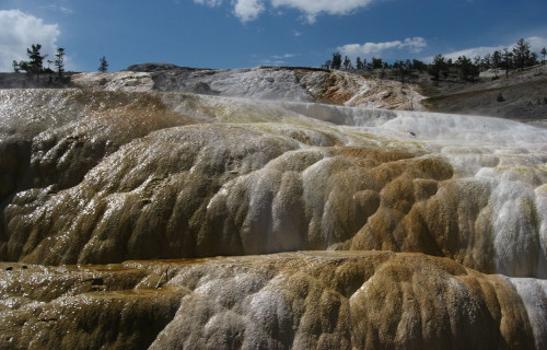
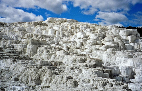
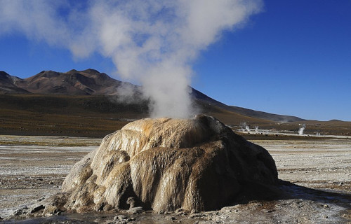
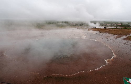
Minerva Springs and Terrace
CCL: https://bit.ly/2Vf6lOj
Minerva Springs and Terrace Facts
- First on our compendium of Earth’s Geothermal Marvels is the spellbinding Minerva Springs and Terrace, in all its splendor.
- Most notably, this fabulous location forms part of the equally beautiful and famous Mammoth Hot Springs.
- This forms a series of travertine terraces, yet only one of the myriad marvels of geology found in Yellowstone Park.
- In addition, this visually stunning marvel of geology formed within the boundaries of three states in the United States, in North America.
- Terrace Mountain at Mammoth Hot Springs also ranks as the largest known carbonate-depositing spring in the world. The most famous feature at the springs is the Minerva Terrace.
- The terraces have been deposited by the spring over many years, but, due to recent minor earthquake activity, the spring vent has shifted, rendering the terraces dry.
CCL: https://bit.ly/3wr2Np7
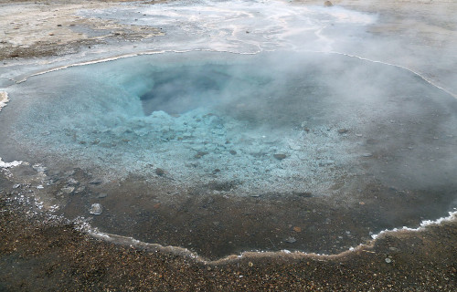
Minerva Springs and Terrace Physical Description
The precise dimension of the breathtaking Minerva Springs and Terrace remains quite impossible to define precisely.
This occurs due to the constantly slightly shifting of its shape due to ongoing geological forces.
The super-heated water, filled with minerals, generally flows slowly over numerous tiered formations.
This creates a rather unique physical appearance at the site.
The terraces themselves formed over extended periods of time due to the deposit of travertine, a form of limestone.
Also, algae found in the water commonly dyes the terraces brown, orange, red and green.
CCL: https://bit.ly/3xACxKA
Minerva Springs and Terrcae Growth
Roughly 500 gallons (1,893 l) of water flow over the Minerva Springs and Terrace each minute, depositing an estimated 4,000 lb (1,814 kg) of calcium carbonate in various colors every day.
The terraces continue to grow through such deposits. Augmenting its great beauty is the multi-colored nature of the water itself.
Thermal activity here remains extensive both over time and distance. The thermal flows also show much variability with some variations taking place over periods ranging from decades to days.
Finally, this hot spring stays heated by the magma chamber beneath Yellowstone, to a temperature of 170 F (80 C).
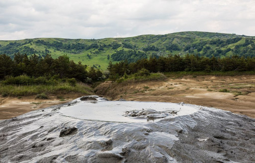
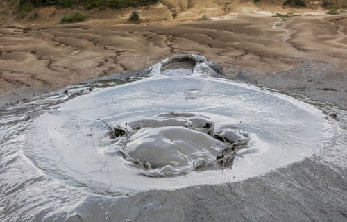
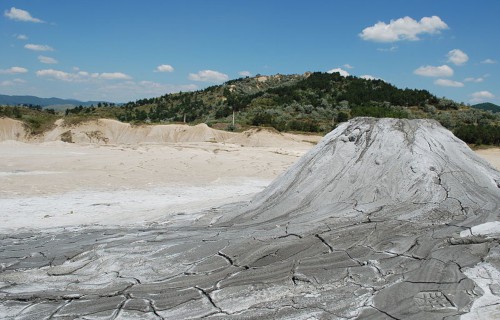
Berca Mud Volcanoes
CCL: https://bit.ly/3ha9nvU
Berca Mud Volcanoes Facts
- The next entry on our list of Earth’s Geothermal Marvels is the unique and truly fascinating Berca Mud Volcanoes.
- These features truly represent a unique sight to see. Consider them miniature volcanoes continuously erupting, but with mud instead of lava.
- As the principal component of a geological and botanical reservation, they also remain unique in Romania, in Europe. Along with the unusual environmental conditions they create, they also form a remarkable landscape.
- Further, many compare it to a piece of the moon brought to earth. Yet, despite the starkness of the landscape, the area is a popular attraction for both local inhabitants and tourists. Some say this is actually due to that same starkness.
CCL: http://bit.ly/2zBWbKi
Berca Mud Volcanoes Origins
Despite their volcanic nature, the Berca Mud Volcanoes are so low in temperature that they are cool.
The pressurized natural gas pushes salty mud deposits to the surface. This begins at a point approximately 9,800 ft (3,000 m) beneath the surface. The natural gas that forms them subsequently escapes in a constant bubbling motion.
Further, the expelled mud is actually only warm since it originates between the layers of the continental crust, and not from the mantle.
After surfacing, the mud quickly dries, forming the characteristic conical shapes. These cones average roughly 9.8 ft (3 m) in height.

CCL: http://bit.ly/2REt4fw
Berca Mud Volcanoes Botanical Uniqueness
Despite the incredible starkness of the resulting environmental conditions around the Berca Mud Volcanoes, a few plant species have found a way to adapt. Life is resilient and adaptable.
However, most vegetation cannot survive in the surrounding soil. That is because the features deposit large quantities of both sulfur and salt as they erupt.
Over the roughly 66 acres (30 ha) encompassed by the Berca Mud Volcanoes, sparse patches of hardy vegetation have adapted to the conditions. These include Nitraria schoberi and Obione verrucifera (both small perennial shrubs).
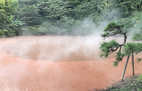
Bloody Hell Pond
CCL: https://bit.ly/3dFT8Va
Bloody Hell Pond Facts
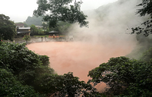
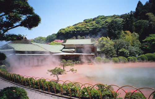
- The third location on our compilation of Earth’s Geothermal Marvels is the eerily beautiful Bloody Hell Pond.
- The Hellish waters of this location occasionally reach temperatures of as much as 194 F (90 C). Hellishly hot indeed. These temperatures would be (obviously) more appropriate for cooking than for use as a spa.
- This marvel of geology, found in Asia, has been known, and utilized by local inhabitants, for more than 1,300 years.
- It actually stays maintained by several small underwater geysers. These spew forth freshly heated (and brilliantly red colored) water at remarkably regular intervals.
- Bloody Hell Pond translates from the original name. The original name in the language of the local inhabitants is Chinoike Jigoku.
- Also, it’s original uses were just as hellish as the color of the water. At one time, the near-boiling temperature of the water was used as a means of torture, then a gruesome execution.
CCL: https://bit.ly/3dLwZVr
Bloody Hell Pond Physical Description
Bloody Hell Pond is a fairly small hot spring. In total area, it covers about 1,300 sq yds (1,087 sq m). Yet its diminutive size certainly doesn’t diminish its seemingly otherworldly nature.
The incredible red hue originates with the extremely high levels of iron oxide and magnesium in the water. Relatively high concentrations of both aluminum oxide and ferrous oxide are also present.
This remarkable pool also has an approximate depth of 90 ft (27.4 m). The underwater geysers that form and maintain the pond spew forth their eerily-hued contents every 40 minutes.
In addition, the ever-present plumes of steam rising from the surface add to the hellish appearance.
Interestingly, the color changes slightly with the weather. On sunny days the pond appears an orange-red. On cloudy days, however, it takes on the semblance of a blood-red scarlet.
CCL: https://bit.ly/3hjxh84
Bloody Hell Pond Location and History
The Bloody Hell Pond is located in the Oita Prefecture, in Japan. The local terrain is predominantly mountainous, and also quite rugged.
The predominant religious beliefs of the local population in ancient times considered that the location resembled a nightmarish underworld. For a period of time, its waters were used as a means of execution by literally boiling to death.
In modern times, the mud and hot water of the site have (ironically) become a source of various skin products. It also serves as one of the largest tourist attractions in the region.
It is not, however, usable as a spa, for obvious reasons. There are other hot springs in the immediate region usable for that purpose, though. Attempting to utilize this site for bathing is (quite understandably) forbidden by law.
El Tatio
El Tatio Facts
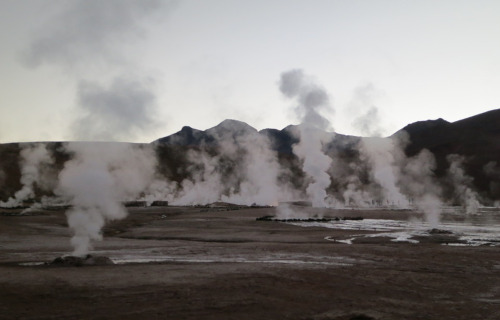
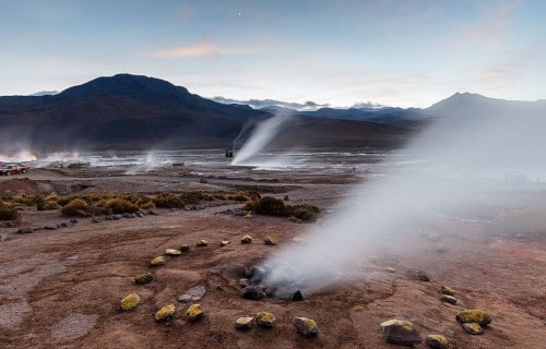
- Our next location in our article on Earth’s Geothermal Marvels is the breathtaking place known as El Tatio.
- This quite incredible site forms an extensive, highly active geyser field. This marvel of geology also sits at a high elevation, within the snow-capped Andes Mountains.
- Located in the northern section of Chile, in South America, El Tatio sits at an altitude of roughly 14, 173 ft (4,320 m). In terms of location, this makes it one of the highest situated such fields known to man.
- The name itself means grandfather, and the location also ranks as rather remote. Further, the nearest sizable population center remains about 55 mi (89 km) away.
- Visiting the site can also be dangerous, however, due to conditions. Further, on occasion, the fragile crust surrounding the geysers gives way beneath the weight of an individual.
CCL: http://bit.ly/2GGxvUT
El Tatio Landscape and Geyser Activity
El Tatio is also surrounded on all sides by the enormous mountains of the Andes. The geyser field boasts more than 80 active geysers. By number, this makes it the largest such field in the Southern Hemisphere. However, two larger fields exist in the Northern Hemisphere.
The majority of the individual geysers measure relatively small, in terms of elevation of the eruption. The average height of the geysers in El Tatio is about 29.5 in (0.75 m ). The most powerful individual geyser averages only 19.7 ft(6 m) in height.
CCL: https://bit.ly/3yhOR25
El Tatio Geothermal Activity
Geysers do not comprise the only geothermal activity that El Tatio remains known for, however. More than 100 steam fumaroles also exist within the area. The majority of these stay continuously active.
The contrast between the steam and the frigid air at the field’s altitude makes for a striking image. Visitors also find several large geothermal pools in the area.
The water within these contains a variety of minerals. These pools remain an almost constant 95F (35C) in temperature. Countless bubbling mud pots also fill the region. Both the mineral pools and the mud pots appear to be popular tourist attractions.
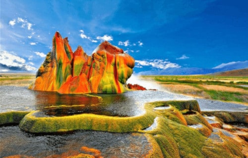
Fly Geyser
Fly Geyser Facts
- The fifth spot among this listing of Earth’s Geothermal Marvels is the absolutely astounding Fly Geyser.
- Most notably, this gorgeous feature constitutes an accidentally man-made small geothermal geyser. It formed in Washoe County, Nevada, United States, in North America.
- The geyser also sits on the private Fly Ranch in Hualapai Flat, about 0.3 mi (0.48 km) from State Route 34. The ranch remains privately owned, and a high fence and a locked gate topped with spikes exclude trespassers.
- The only access consists of a dirt road, but this breathtaking geyser remains viewable from the road.
- The geyser itself only stands about 5 ft (1.5 m) high, however. If you also include the mound it sits on, it measures a total of 12 ft (3.7 m) high.
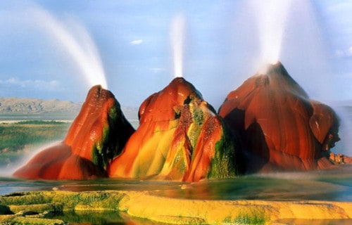
Fly Geyser Origins
Firstly, the stunning Fly Geyser accidentally formed in 1964. It occurred due to the digging of a well as part of an exploration for geothermal energy. It continues to be unclear whether the people failed to cap correctly, or not.
As a result, dissolved minerals began rising and accumulating. This further led to the creation of the travertine mound on which the geyser sits and continues to slowly grow.
To date, super-heated water continues to be released. The triple spumes reach nearly 6 ft (1.8 m) into the air.
Also, the Fly Geyser contains several terraces discharging water into 30 to 40 pools over an area of 74 acres (30 hectares).
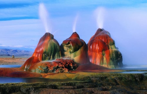
Fly Geyser Nature
The Fly Geyser mound consists of a series of different minerals, but its incredible colors occur due to thermophilic algae, making it most visually impressive.
A prior well-drilling attempt in 1917 resulted in the creation of a man-made geyser close to the currently active site. This earlier drilling created a pillar of calcium carbonate.
However, it ceased when the geyser began releasing water in 1964.
Two additional geysers in the area formed in a similar way and continue to grow. The first is roughly 3 feet (0.91 m) and looks like a miniature volcano while the second is cone-shaped and is almost twice as tall.
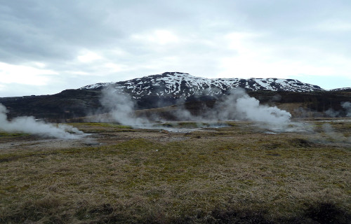
Haukadalur Geothermal Area
CCL: https://bit.ly/3jAyTfr
Haukadalur Geothermal Area Facts
- The next incredible spot on our list of Earth’s Geothermal Marvels is the impressive Haukadalur Geothermal Area.
- This mesmerizing spot forms an extraordinary region of geological beauty in southern Iceland, in Europe. In fact, one of the geysers found in the area actually represents one of the first geysers that modern man discovered.
- In addition, the earliest known recorded mention of the spectacular landscape features was in 1294. Further, at that time, an earthquake activated numerous hot springs within the region.
- The region has also been a major attraction for tourists since the 18th century and continues to thrive in that regard.
CCL: http://bit.ly/2QZT99x
Haukadalur Geothermal Area Origins and Nature
The Haukadalur Geothermal Area originally formed at the end of the last Ice Age. Yet, occasional earthquakes in the region continue to alter its nature even today. The last such earthquake in the region occurred in July of 2000.
There are currently 40 geothermal based features present in the remarkable region. All of these are volcanic in nature. They include multiple geysers, hot springs, fumaroles, and mud pots.
The largest of the geysers is Strokkur and many of the geysers are comparatively regular in the timing of their eruptions.
CCL: https://bit.ly/3ArMDim
Haukadalur Geothermal Area Physical and Biological Distinctiveness
Several of the small springs in the area are quite unique. The water within them is sodium bicarbonate thermal water due to the extremely high concentrations of sodium bicarbonate.
These same streams in the Haukadalur Geothermal Area also contain comparatively high concentrations of radon.
Living within this unique environment are numerous species of microorganism and algae that have adapted to survive within the unique water and extreme heat. In fact, many of them are incapable of surviving in water temperatures below 158 F (70 C).
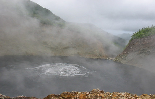
Boiling Lake
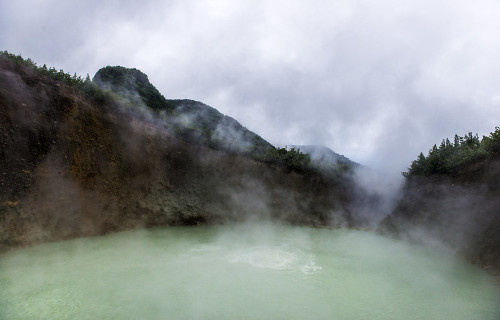
Photo: Göran Höglund (Kartläsarn)
CCL: https://bit.ly/3w716Nr
Boiling Lake Facts
- Placing seventh on our list of Earth’s Geothermal Marvels is the dazzling and surprising Boiling Lake.
- The most noteworthy fact about this place remains its status as the second-largest hot lake in the world. In addition, it itself forms part of the Morne Trois Pitons National Park, which is a World Heritage Site.
- The first ever recorded sighting of this geological marvel was in 1870, by Edmund Watt and Henry Nicholls. Also, the first scientific investigation of the site was carried out in 1875.
- Not only is it extremely unique, but its location also ranks as somewhat remote. The nearest road sits about 8.1 mi (13 km) from the site, thus access remains limited.
- Interestingly, the site stays active, so will occasionally drain, and even form geyser-like fountains of hot water and steam. Occasionally, it will even empty and refill in only a single day.
CCL: https://bit.ly/3jyrTjk
Boiling Lake Physical Description
Firstly, the dimensions of the Boiling Lake remain constantly variable, depending upon conditions. Typically mild phreatic eruptions in the region occur periodically and dramatically affect the level of the small lake.
However, its diameter averages between 200-250 ft (61-76 m) across. The depth of the lake naturally also varies, yet an average depth has been determined to be about 195 ft (59 m).
The color of the water also varies, including becoming green, yet usually, ranges from grayish-blue to bright blue. In addition, the temperature of Boiling Lake ranges between 180-197 F (82-92 C).
This flooded fumarole sits amid jagged outcroppings of rock, which average approximately 100 ft (30 m) in height. Besides to the ever-present steam, the site will occasionally spew forth various noxious gases as well.
CCL: https://bit.ly/3qFeVl7
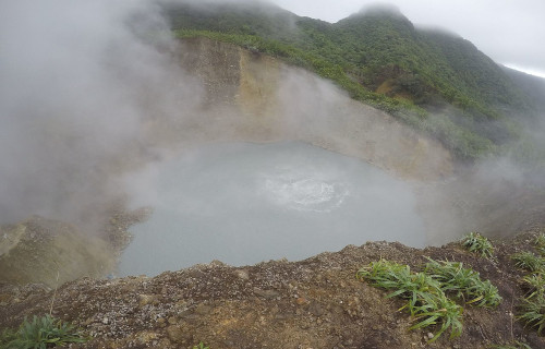
Boiling Lake Formation and Location
The beautiful yet dangerous Boiling Lake sits about 6.5 mi (10.5 km) east of the town of Roseau, Dominica, near South America. Consequently, the site not only has the distinction of being remote, but the surrounding terrain also presents rugged conditions.
The water originates from plentiful rainfall and two small streams that flow into the site. As a result, the water becomes super-heated by proximity to the underlying magma chamber.
Various combinations of minerals in the water create the color, which varies, yet generally remains either bluish gray or bright blue.
Being rather porous in nature, the surrounding rocks also allow the water to escape rapidly when the nearby volcanic activity interrupts the regular inflow.
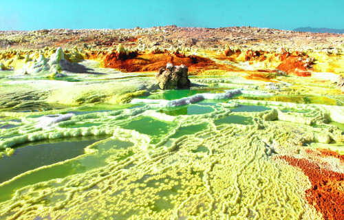
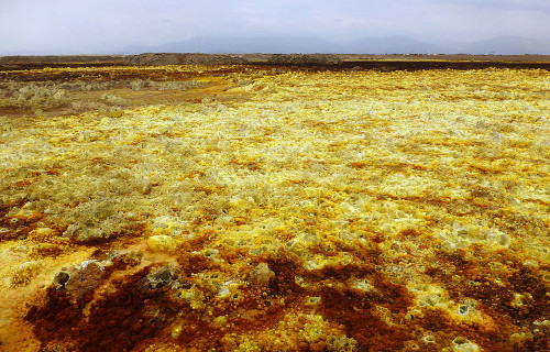
Dallol Hydrothermal Field
CCL: https://bit.ly/3Ad8z0O
Dallol Hydrothermal Field Facts
- Placing next on our list of Earth’s Geothermal Marvels is the wondrous location known as the Dallol Hydrothermal Field.
- Firstly, the breathtaking location represents an incredible wonder of geology that formed in a rather isolated and remote part of the world.
- The field also officially ranks as the lowest known subaerial volcanic region on earth. From the perspective of uniqueness, it remains one of the world’s most spectacular landscapes.
- This astonishing location also ranks as one of the hottest and driest locations on the planet. This simply serves to augment the enhance the uniqueness of the landscape.
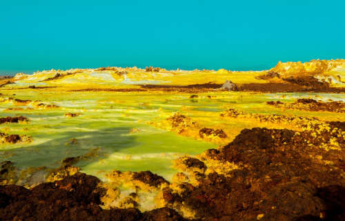
Dallol Hydrothermal Field Physical Description
In terms of overall average temperatures, the remarkable Dallol Hydrothermal Field also represents one of the hottest locations in the world that scientists currently know of.
In addition, the mean annual temperature is approximately 86 F (30 C).
However, the central feature of the site remains the Dallol volcano which has a rather broad shape and averages about 1 mi (1.6 km) in width.
However, it measures quite low, measuring roughly 164 ft (50 m) in height.
The surrounding region has numerous associated geological features, such as hot springs, brine pools, multicolored sand deposits, miniature geysers, and even acid pools.
CCL: https://bit.ly/2SBqk8X
Dallol Hydrothermal Field Location and Geology
The mind-blowing Dallol Hydrothermal Field formed in the northern Danakil Depression in what now constitutes Ethiopia, in Africa.
This amazing formation also sits at an astonishing 269 ft (82 m) below sea level.
This site comprises a rather expansive region of uplifted and quite thick salt deposits which intense fumarolic activity continuously affects.
Geologists believe that the presence of an active volcanic system beneath several miles of salt deposits perhaps serves as the major culprit.
The most recent of the many craters formed in 1926, as the result of a type of volcanic event known as a phreatic eruption.
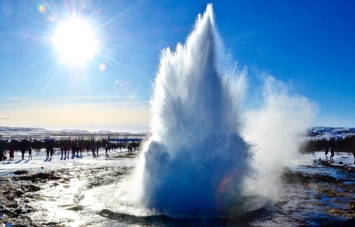
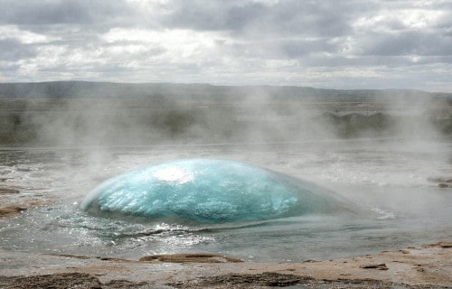
Strokkur Geyser
CCL: http://bit.ly/2OUHszC
Strokkur Geyser Facts
- The ninth entry on our list of Earth’s Geothermal Marvels is the magnificent and remote Strokkur Geyser.
- This awesome force of Nature represents a powerful fountain geyser found in a geothermal area in a remote and sparsely populated portion of Europe.
- The beautiful and extremely regular geyser remains one of the most famous of its kind within the region in which it formed.
- Further, this marvel of geology erupts in a steady frequency range of between 4-8 minutes. Variations in the schedule rarely occur.
- This lovely geyser also remains one of the few known geysers to erupt with a regular frequency. Another is located in the United States.
This has, quite understandably, made it a leading tourist attraction in the region.
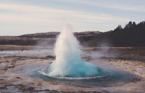
Strokkur Geyser Physical Description
Eruptions of Strokkur Geyser attain an average height of between 49.2-65.6 ft (15-20 m). Yet exceptional occurrences occasionally attain a height of as much as 131 ft (40 m).
It also comprises part of the Haukadalur valley area. There, numerous other geothermal features also exist. These include fumaroles, mud pools, and other geysers that continue to be located around it.
Shortly before eruptions, the pool of hot water fills and then pulses up and down rhythmically. Following this, a large bubble forms, and then the eruption spews forth.
CCL: https://bit.ly/24dGLTK
Strokkur Geyser Location and History
Most notably, geological evidence indicates that Strokkur Geyser formed roughly 1,000 years ago, subsequent to an earthquake the geologically active region.
The earliest recorded reports of its activity date back to the year 1294. At an uncertain time after this, another quake deactivated the site.
In 1789, yet another quake reactivated it. It also subsequently remained active until 1896 when still another earthquake deactivated it once again.
In 1963 local residents succeeded in unblocking Strokkur Geyser once again, and it has remained active since that time.
This constitutes the only recorded instance of human actions intentionally creating or reactivating a geyser.
Finally, this wonder of Nature formed in what now constitutes the country of Iceland. This area is beside the Hvita River, in the southwest portion of the country.
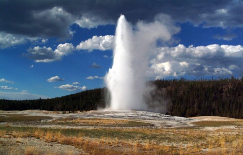
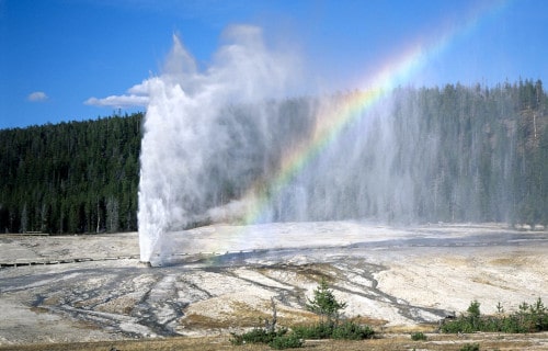
Old Faithful
Old Faithful Facts
- The next wonder on our list of Earth’s Geothermal Marvels is the astounding and famous Old Faithful.
- This feature represents a cone-type geyser located in Yellowstone National Park, in the United States, in North America. It also remains famous for being one of the most predictable geological features on the planet.
- The geyser received its name from the members of an expedition in 1870. Though not the largest geyser in the park, it certainly serves as the most predictable and regular.
- Between 1983 and 1994, four different scientific surveys lowered instruments into the geyser for research purposes. But, though many measurements took place, 72 ft (22 m) continues to be the deepest that probes have ever been able to reach.
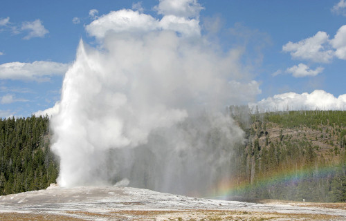
Old Faithful Eruptions
Old Faithful remains perhaps the most closely observed marvel of geology on earth. More than 137,000 eruptions have been monitored and recorded.
Nevertheless, eruptions of the site vary in interval, duration, volume, and height. However, these all fall within a given range, following regular patterns, and last between 1.5-5 minutes.
Intervals between eruptions stay between 45-125 minutes and average 90 minutes today. The average once only measured 66.5 minutes. The volume of water ejected ranges between 3,700-8,400 US gallons, depending upon the duration.
The average height of the ejecta usually reaches 145 ft (44 m).
CCL: https://bit.ly/3k1cW9l
Old Faithful Predictability and Interval
During the time that recordings of the patterns of Old Faithful have been kept, the interval between eruptions has changed. The average interval now measures significantly longer than it once did.
Scientists believe this to be the direct result of numerous small earthquakes within the area. These they also believe responsible for altering the levels of the subterranean water deposits which feed the geyser.
However, these alterations actually made the geyser even more predictable than before. So, the greater the duration of a given eruption, the more extended the next interval will be.
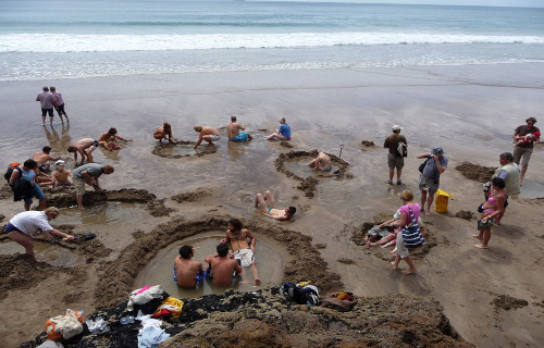
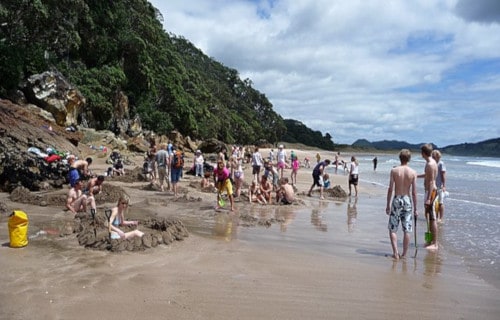
Hot Water Beach
CCL: https://bit.ly/349xXWf
Hot Water Beach Facts
- The eleventh of our choices of Earth’s Geothermal Marvels is the truly unique site known as Hot Water Beach.
- An outing to the extraordinary beach would likely be the one time you actually want to find yourself in hot water while on a trip to the beach.
- The aptly named beach is an extremely unusual geological interface between the ocean and naturally occurring hot springs. This amazing location forms part of Mercury Bay, in New Zealand.
- During part of the day, the localized hot springs remain submerged beneath the waves.
- However, for roughly two hours before low tide, and two hours afterward each day, the unique feature of this site appears. Therefore, you must catch it at just the right time.
CCL: http://bit.ly/2xQPH8p
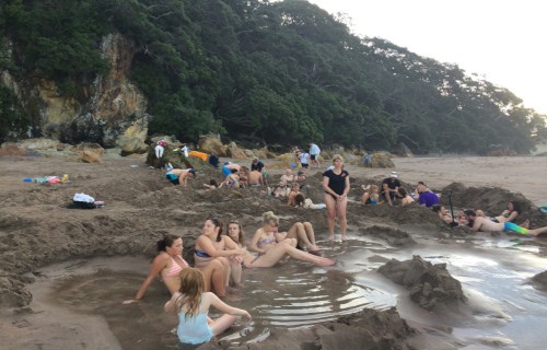
Hot Water Beach Geothermal Nature
Hot Water Beach owes its nature to the presence of underground hot springs situated almost directly beneath the small beach.
The hot water rarely does more than slightly bubble above the surface on its own.
However, digging even slightly into the sand of the beach will cause the cavity to be filled with hot water.
The heated water filters up from two small fissures situated quite close to each other. The water from the hot spring sometimes reaches temperatures of as much as 147 F (64 C).
CCL: https://bit.ly/3oHRuqv
Hot Water Beach Tourism and Dangers
Unsurprisingly, the uniqueness of this beach has made it a popular vacation spot for both local inhabitants and tourists. Approximately 700,000 people visit the site annually.
The spot does have its perils, however. Even during low tide, the beach sits in close proximity to the waves, which can be large and powerful.
As if this wasn’t enough, powerful rip currents also quite commonly occur in the area.
Groupings of large rocks also sit just offshore. Though lifeguards do watch the area, officials wisely recommend that only highly experienced swimmers or surfers venture beyond the beach itself.
We sincerely hope that you have enjoyed this article on Earth’s Geothermal Marvels. These sites, and others like them around the world, beguile us with their power and beauty. They give us a small glimpse into just how active our world still is. But we must do all that we can to protect them from the depredations of man. They deserve to be preserved as Nature created them.
Check out our other articles on 6 Incredible Asian Islands, North American Gulches and Canyons, 9 Truly Magnificent Mantises, Earth’s Extremely Threatened Flowers