


Earth’s Many Stunning Waterfalls
This tribute to Earth’s Many Stunning Waterfalls should come as no surprise to anyone who has ever enjoyed their beauty. Water is the source of all life on this planet, and mankind has held a deep fascination with it since time immemorial.
This understandable fascination is only increased by the sheer beauty and splendor that Nature creates in the form of waterfalls. Most of you have probably encountered at least a few in your lives. We hope you enjoy learning about these examples.
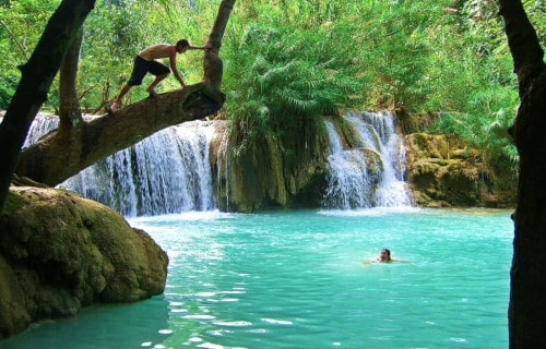
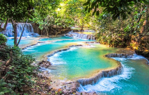
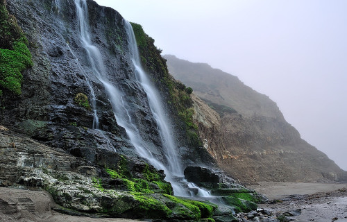
Kuang Si Falls

CCL: http://bit.ly/2OUHszC
Kuang Si Falls Facts
- The first of our choices of Earth’s Many Stunning Waterfalls is the magnificent Kuang Si Falls.
- Most notably, the remarkable site known as Kuang Si Falls ranks as an astonishingly beautiful waterfall. Not only that, but Nature blessed it with truly incredible qualities. It also has a somewhat remote setting, which serves to limit tourism. Consequently, the magnificent location remains comparatively pristine.
- Also worthy of note is the fact that this geological masterpiece formed in what now constitutes northern Laos, in Asia. In addition to everything else, the local terrain stays quite rugged. That holds true of its own specific location, so few tourists visit the spot without a guide.
- Furthermore, due to the dangerous conditions in the region, bridges and walkways surround the site for safety. This serves to both protect visitors and to preserve its natural state. As a result of its great beauty, the location has been named a World Heritage Site. This well-deserved honor showcases the ethereal beauty of the entire location.
CCL: http://bit.ly/2xQPH8p
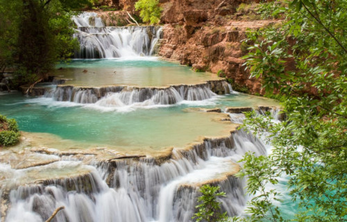
Kuang Si Falls Formation
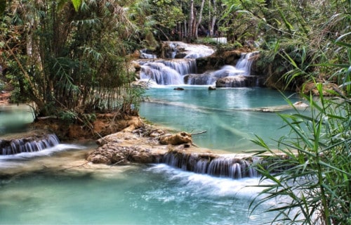
First of all, the amazng Kuang Si Falls remains a truly mesmerizing example of what experts call a three-tiered waterfall. However, it actually has humble origins, beginning as mere shallow pools on a steep hillside. Further, these pools subsequently flow into the main fall, which itself measures a total of 200 ft (60 m) high.
Additionally, a naturally occurring small level landing also appears at the bottom of the main fall. Yet another set of much smaller ones follow, only a short distance away. Not only that, but at the bottom, numerous small pools also formed. These only serve to augment its already great beauty.
But Nature did not cease its artistic efforts there. That’s because, at the same time, a multitude of miniature cascades flows from these pools. Additionally, quite a few of these gorgeous outpourings measure as much as 16 ft (5 m) in height themselves. But, though these remain much smaller, they seem no less beautiful.
Kuang Si Falls Distinctiveness
The breathtaking Kuang Si Falls derives its fabulous scenery due to several naturally occurring factors. It forms a travertine waterfall where limestone in the water deposited over the ages. However, while the numerous unique formations developed due to this action, the splendor of this location doesn’t depend solely on its geology.
In addition, to its many other incredible features, the wonderful water of the site also has incredible turquoise color. Also adding to its character is the fact that this water stays quite cold, regardless of the season. In one area of the location there also exists a comparatively large pool which many locals and tourists alike use for swimming.
Most of all, however, the dense surrounding jungle also gives the location a naturally occurring, and perpetual otherworldly feeling. Yet one of the larger pools continues to be off-limits to tourists, however. That occurs due to the fact that it is considered a sacred site by the local inhabitants.
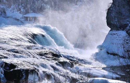
Rhine Falls
CCL: https://bit.ly/3ApateQ
Falls Facts
- Next among our choices of Earth’s Many Stunning Waterfalls is the fabulous one known simply as the Rhine Falls.
- First of all, probably the most noteworthy fact about the magnificent Rhine Falls remains its status. That holds true because the feature ranks as the largest waterfall in Europe. Consequently, and not surprisingly, its natural magnificence has served to inspire authors, poets, and painters for centuries.
- Further, it has its fair share of concerns, however. That’s because the sheer power of this geological marvel often makes it a potential source of hydroelectric power for surrounding regions. Thankfully, the public pressure to preserve the waterfall has thus far prevailed.
- Thankfully, it has never been used for generating electricity. However, mankind has utilized its power in other ways in the past. In fact, the tremendous strength of the waterfall has previously been utilized as a source for both a mill and an iron ore smelting facility.
- Finally, the awesome Rhine Falls presently remains one of the most popular tourist sites in Europe. This fact represents one of the reasons hydroelectricity has been ruled out. Additionally, the presence of Worth Castle nearby also augments the site’s beauty.
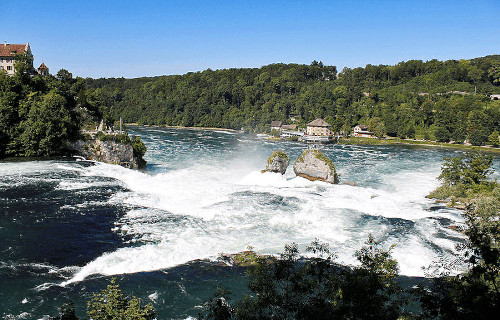
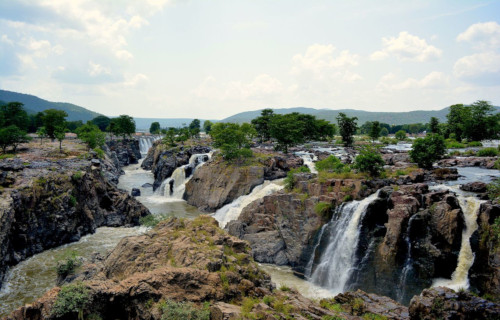
Rhine Falls Physical Description
Perhaps most notably, the astonishing Rhine Falls is an impressively large site. In fact, the marvelous cascade measures roughly 490 ft (150 m) in overall width. The waterfall itself has a moderate drop measuring a total of about 75 ft (23 m). Further, this marvelous waterfall itself sits at an elevation that measures roughly 1,194 ft (364 m).
Yet, it does not remain the same size at all times. In fact, its flow rate naturally varies by season, being greater in the summer than other times of the year. This variation happens due to run-off from mountain snowfall. In winter, the flow rate averages 8,800 cu ft/s (250 cu m/s), yet increases to a massive 21,000 cu ft/s (600 cu m/s) in summer.
lso worthy of note is the fact that the land the waterfall flows over primarily consists of limestone. Also, the out-flowing riverbed following the waterfall itself has a deep cover of gravel, likely from glacial activity. The World Waterfall database officially lists Rhine Falls as a magnificent example of what experts call a Segmented Block waterfall.
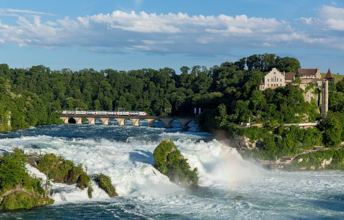
Photo: Kabelleger / David Gubler
CCL: https://bit.ly/3hr6cPk
Rhine Falls Location and Formation
Most notably, perhaps, is the location of the gorgeous site. That holds true because Nature placed the Rhine Falls on the High Rhine, rather near the border between the cantons of Zurich and Schaffhausen, Switzerland.
Remarkably, these magnificent falls formed between 14,000 – 17,000 years ago, during the last ice age. Further, this formation occurred because melting glaciers filled channels carved out by their previous expansion with torrential amounts of runoff.
While the source of the waterfall, the Rhine river, once flowed in another direction, it moved to its current course approximately 132,000 years ago. Consequently, this allowed for the formation of the waterfall once the glaciers retreated, as the moving water eroded the surrounding limestone.
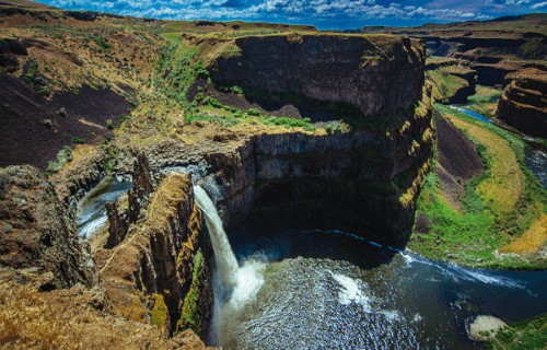
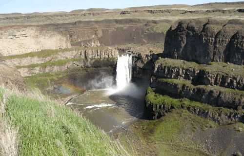
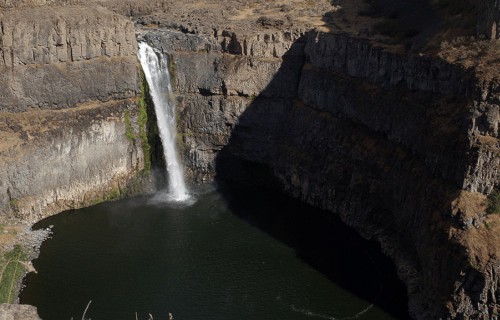
Palouse Falls
CCL: https://bit.ly/1ryPA8o
Palouse Falls Facts
- Placing third out of our choices of Earth’s Many Stunning Waterfalls is the gorgeous Palouse Falls. However, its placement bears no reflection on its beauty.
- Firstly, the term serves as the name of a rather remote waterfall, located on the Palouse River. It also sits roughly 4 mi (6.4 km) upstream from where the river joins the much larger Snake River.
- Both of these formed in the state of Washington, in the United States, in North America. As a result of its beauty, the falls constitute the central feature of a large park there, the Palouse Falls State Park.
- On February 12, 2014, the Washington House of Representatives passed a bill specifically pertaining to this site. In it, they unanimously chose this stunning site as the official state waterfall in Washington.
- Finally, the proposal for the bill actually began in a most unique manner. That’s because it started when a group of elementary school students in a nearby town decided to lobby the state legislature.
Public Domain Image
Palouse Falls Physical Description
Most notably, the breathtaking Palouse Falls represents a variety of waterfall known as a two-tiered waterfall. Its first drop is small, with the upper falls measuring only 18 ft (5.9 m). However, the second drop lies about 1,000 ft (305 m) from the upper falls. The lower falls portion measures about 180 ft (55 m).
In addition, both sections of the beautiful waterfall reside within an amazing location in its own right. This is a canyon which measures roughly 337 ft (115 m) in depth and remains surrounded by vast scablands.
This area also remains highly characterized by many other features. These include interconnected flood-created coulees, cataracts, plunge pools, potholes, rock benches, buttes, and pinnacles. The Missoula Floods which swept through the region repeatedly during the Pleistocene Epoch formed both the canyon and falls.
CCL: https://bit.ly/24dGLTK
Palouse Falls Economic and Recreational History
First of all, in 1984, the government presented a plan that many people living in the region strongly opposed. That’s because officials proposed the construction of a 98 ft (30 m) high dam upstream from Palouse Falls.
The idea was to provide less expensive hydroelectricity for the region. However, a significant majority of local residents voted against the construction because they preferred to retain the higher electric rates in return for preserving the falls.
Due to the efforts of the populace, the area has maintained the majority of its natural beauty. As a result, the areas surrounding the falls now serves as a popular recreational spot, most especially for those who enjoy kayaking.
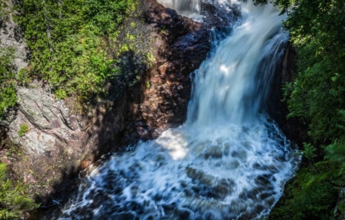
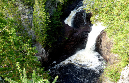
Devil’s Kettle Falls
CCL: http://bit.ly/2xLZ0ap
Devil’s Kettle Falls Facts
- Our next selection for inclusion in this articles about Earth’s Many Stunning Waterfalls, Devil’s Kettle Falls, earns its spot due to its rather remarkable air of mystery.
- The mysterious, not to mention appealing,secluded waterfall constitutes an almost unknown natural wonder.
- It also remains a mystery that still defies explanation. And who doesn’t love a good mystery?
- This unique waterfall known as Devil’s Kettle Falls remains a central part of the Judge C.R. Magney State Park.
- It is situated in the state of Minnesota, in the United States.
- The waterfall forms part of the final stages of the Brule River, as it approaches Lake Superior.
- It is here that a mystery occurs that remains unexplained to this day. Do you find yourself intrigued yet?
CCL: https://bit.ly/3yKAPq5
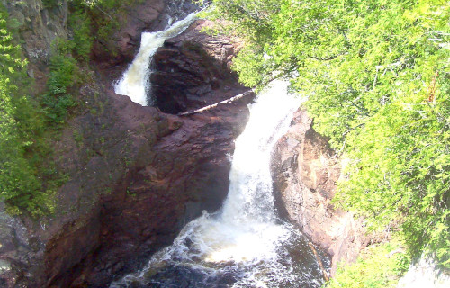
Devil’s Kettle Falls Geology
To the naked eye, the Geology of Devil’s Kettle Falls seems unremarkable, though certainly pleasing to the eye.
The waterfall occurs roughly 1.5 mi (2.4 km) before the end of the Brule River. The river drops an impressive 800 ft (244 m) over the course of only 8 mi (12.8 km), before flowing over a unique waterfall.
This flow gets divided by an outcropping of a type of volcanic rock known as rhyolite.
Its eastern section plunges nearly 50 ft (15 m) down a two-stage cascade. However, the other portion holds the beginning of the mystery.
CCL: https://bit.ly/3hSUcq3
Devil’s Kettle Falls Mystery
The unexplained phenomenon we call Devil’s Kettle Falls began perplexing mankind even before the first Europeans arrived on the continent. The Native Americans knew it well.
On the western side of the waterfall, the water swirls down a large hole in the rock. This hole measures approximately 10 ft (3 m) in diameter. No investigator, professional or amateur, has ever been able to determine.
It was once assumed it flowed into a subterranean river, into nearby Lake Superior. However, scientists have investigated, sending everything from ping pong balls to dye, to sensors down the flow.
No sign of any of these has ever been detected anywhere in the world, proving that Nature still keeps her mysteries.
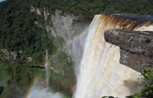
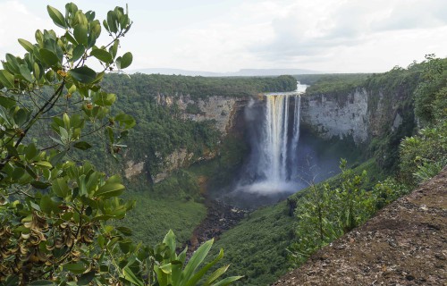
Kaieteur Falls
CCL: https://bit.ly/1E6HPMf
Kaieteur Falls Facts
- The fifth of our choices of Earth’s Many Stunning Waterfalls, the awesome Kaieteur Falls will take your breath away with its splendor.
- This geological feature is a magnificent high-volume waterfall and also forms a central part of the Kaieteur National Park within the Essequibo Territory, Guyana. The falls are also situated in the middle of Guyana’s rainforest.
- The Potaro River supplies this marvel of geology and flows from the escarpment of the Pakaraima Mountains while eventually flowing into the Essequibo River. The river is among the widest and longest rivers in all of South America.
- The name of the falls comes from a local legend which narrates that an unpleasant old man was once placed in a boat and shoved over the falls by his relatives. Therefore, the fall’s name is Kaieteur which literally means old man fall.
CCL: https://bit.ly/1p2b8Ke
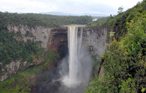
Kaieteur Falls Physical Description
Kaieteur Falls sits at an elevation of about 4,380 ft (1,335 m). It is a single drop waterfall and also ranks as the 123rd highest waterfall on earth.
The waters of this incredible site also plunge roughly 741 ft (226 m) to the rocks below.
Though not among the tallest, it has one of the highest volumes of all known waterfalls. It generates an average flow rate of roughly 23,400 cubic ft (663 cubic meters) per second.
This incredible rate of flow gives it the 19th greatest flow rate of any known waterfall.
CCL: https://bit.ly/1jxQJMa
Kaieteur Falls Geology
Kaieteur Falls flows over a cliff composed primarily of sandstone. At the bottom of the plunge, the water flows over a series of steep cascades.
If taken as part of the measurements, they give Kaieteur Falls a total drop of about 882 ft (251 m). The width of the falls measures around 500 ft (152 m)..
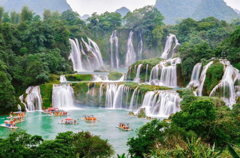
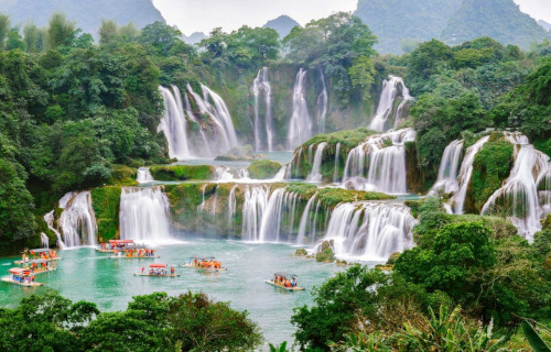
Ban Gioc-Detian Falls
Ban Gioc-Detian Falls Facts
- Next up in this compendium of Earth’s Many Stunning Waterfalls, Ban Gioc-Detian Falls, looks like something out of a dream or fairy tale.
- This natural wonder remains a rather spectacular sight; twin waterfalls on the Quay Son River, almost perfectly straddling the Sino-Vietnamese border, in Asia.
- One-half of the falls sits in the karst hills of Daxin County, Guangxi (China), and the other half – in Trung Khanh District, Cao Bang Province (Vietnam).
- The site also sits roughly 169 mi (272 km) north of Hanoi.
- These falls currently rank as the 4th largest waterfall along a national border, after Victoria Falls, Iguazu Falls, and Niagara Falls.
- The Vietnamese people consider the two falls to be two parts of one waterfall with the sole name Bản Gioc. Furthermore, the two parts are as thác chính (Main waterfall) and thác phụ (Subordinate waterfall).
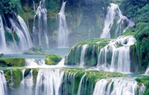
Ban Gioc-Detian Falls Description
Chinese texts sometimes name Ban Gioc-Detian Falls simply the Détiān falls. During the summer rains, the two waterfalls may also join together.
The waterfall drops a total of about 98 ft (30 m) and is separated into three falls by numerous rocks and trees.
During the summer rains, the two waterfalls may join together. Then, the waterfall drops a total of about 98 ft (30 m) and is separated into three falls by numerous rocks and trees.
On most days, the thunderous effect of the water hitting the cliffs is audible from a great distance.
The place was also one of the crossing points for the Chinese army during the brief Sino-Vietnamese War.
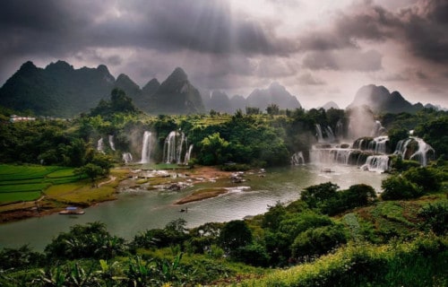
Ban Gioc-Detian Falls Ecology
Near Ban Gioc-Detian Falls is the Tongling Gorge, accessible only through a cavern from an adjoining gorge. Rediscovered only recently, it has many species of endemic plants that exist only in the gorge.
In the past, this cavern was a hideout for local bandits. In fact, the treasures are occasionally still found in the cliff-side caves.
A road running along the top of the falls leads to a stone marker that demarcates the border between China and Vietnam in both Chinese and French.
However, modern disputes arose, as there are discrepancies as to the correlating legal documents on border demarcation and the placement of markers between the French and Qing administrations in the 19th century.
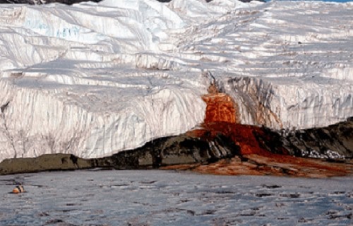
Blood Falls
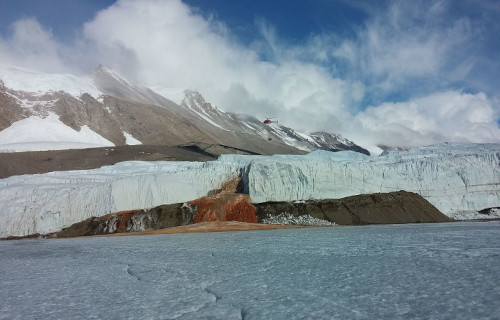
Photo: Jill Mikucki/University of Tennessee Knoxville
CCL: https://bit.ly/34aBrrQ
Blood Falls Facts
- Now for the seventh of our selection of Earth’s Many Stunning Waterfalls, we chose the truly unique and surprising Blood Falls.
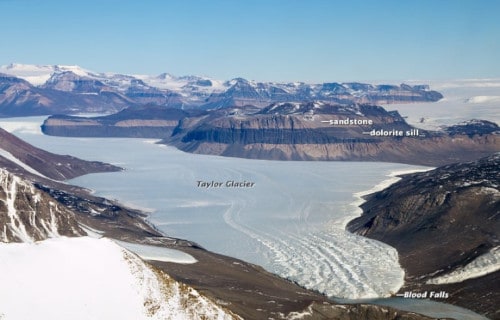
- This remarkable site represents an extraordinarily unique wonder of geology. It is an outpouring of melting salt water, which flows from a point on the Taylor Glacier.
- From there, the Blood Falls pour onto the frozen surface of West Lake Bonney which is in McMurdo Dry Valley, in the eastern section of Antarctica.
- This feature is famous for its constant blood red color.
- The same processes which form this wonder of nature serve to make Blood Falls of extraordinary interest to microbiologists.
- It is also of great interest to astrobiologists, who study it as a means of evaluating the possibility of life’s existence in harsh environments on other planets.
Public Domain Image
Blood Falls Geochemical Formation
The remarkable Blood Falls is an outpouring of iron-rich, hypersaline water which flows from small fractures in the layers of ice.
The source of the water is a subglacial pool, lying beneath approximately 1,300 ft (400 m) of ice. This pool sits about 2 mi (3.2 km) from the point where it emerges from the ice.
The precise size of the pool which spawns the Blood Falls also remains undetermined. Beneath the glacier, and between it and the underlying rock layer, is a region of brine with such a high saline level that it has remained liquid.
Rather high concentrations of ferric oxide within the deposit create a unique color.
Blood Falls Microbial Ecosystem
Due to its inherently unique development, Blood Falls also contains an incredible ecosystem of its own. Within its depths, autotrophic bacteria evolved and those actually metabolize ferric materials and sulfates for nourishment. In simple language, that is like eating iron.
An analysis of the water of the falls shows it contains at least 17 different species of microbes, and virtually no oxygen. Further, these microbes utilize sulfates as a catalyst for respiration.
Blood Falls is the only known place on earth where a form of life utilizing this metabolic process has been discovered. The rather amazing location presents scientists with the ability to study such a unique ecosystem thankfully without the need to drill down to it.
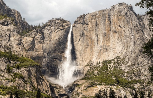
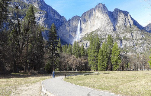
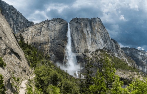
Yosemite Falls
Public Domain Image
Yosemite Falls Facts
- No article detailing Earth’s Many Stunning Waterfalls would be complete without mention of the awesome Yosemite Falls.
- Fist of all, the truly magnificent and often breathtaking feature remains the highest known waterfall in North America.
- It also forms a principal part of the Yosemite National Park. It comprises one of the key attractions of the park, especially in the spring, when the water flow reaches its heaviest.
- The base of the falls once served as the location of the main village of the indigenous Native Americans of the valley, named the Ahwabneechee tribe.
- The large plunge pool at the base of the falls served as a central component of their lives, as well as their mythology.
Yosemite Falls Physical Desription
The total measured height of the stunning Yosemite Falls measures roughly 2,425 ft (739 m). It forms a multi-tiered waterfall, composed of three primary divisions.
These we call the Upper Fall, the Middle Cascade, and the Lower Fall. The Upper Fall plunges 1,430 ft (440 m). This portion alone stands apart as one of the twenty highest waterfalls on earth.
The Middle Cascades account for another drop of 675 ft (206 m). This section actually comprises five smaller, individual falls.
The Lower Falls drop the final 320 ft (98 m). The large plunge pool at its base remains surrounded by a rather treacherous jumble of talus.
CCL: https://bit.ly/1p2b8Ke
Yosemite Falls Location, Distinctiveness, and Dangers
The gorgeous Yosemite Falls remains considered one of the most beautiful sites in its region. This geological beauty lies situated within the Sierra Nevada mountain range, in California, in the United States.
Each year, unless rainfall totals in the surrounding region surpass the usual, the flow of water ceases entirely during either the late summer or fall.
Rock climbers occasionally take this opportunity to scale the normally inaccessible rock face at this time. However, this remains extraordinarily dangerous.
One scattered thunderstorm could send a surge of water over the falls, plunging the climbers to their deaths.
The local Ahwabneecheee tribe hold the legend that the plunge pool at the base of the falls is inhabited by the spirits of several witches, known as the Poloti.
Gocta Cataracts
CCL: https://bit.ly/2yCTWYM
Gocta Cataracts Facts
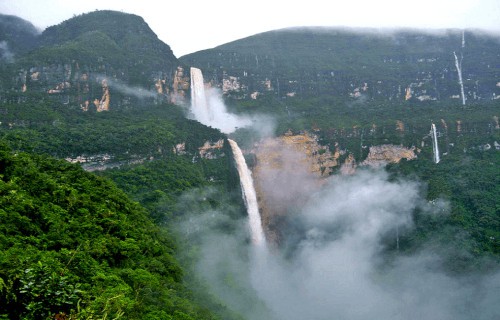
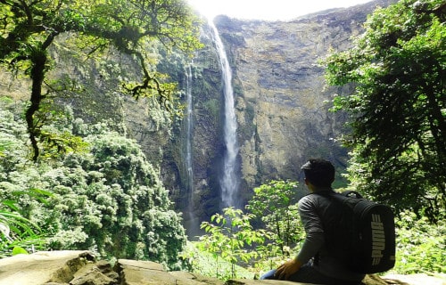
- Placing ninth on this listing of Earth’s Many Stunning Waterfalls, though only due to random selection,comes the other worldy beauty known as the Gocta Cataracts.
- The stunning marvel of Nature forms an incredible waterfall in an extremely remote section of the world, in Peru. It also ranks as the fifth highest waterfall that men know of.
- Though indigenous peoples knew about this place for centuries, it was completely secret to the rest of the world until 2005.
- The magnificent site flows into the Cocahuayco River. The area remains extremely remote, and the local terrain stays quite rugged and with a heavy forest.
- Yet, that does not scare tourists at all and a burgeoning tourist presence now appears to be developing in the area, despite the difficult terrain.
CCL: http://bit.ly/2zBWbKi
Gocta Cataracts Physical Description
The gorgeous Gocta Cataracts serves as a beautiful example of high altitude geology. The uppermost part of the waterfall lies at an altitude of about 7,500 ft (2,286 m).
Further, this marvel has two tiers and has a combined drop of an astounding 2,531 ft (771 m).
The upper section drops roughly 700 ft (213 m) while the lower falls plummets an incredible 1,831 ft (558 m). Also, the maximum width of the entire site measures roughly 200 ft (61 m).
The altitude at which this marvel of Nature formed is situated is sufficient that at times the uppermost portion is obscured by clouds.
CCL: https://bit.ly/2yCTWYM
Gocta Cataracts Location and History
The beautiful Gocta Cataracts lies within what ranks as one of the most remote and difficult to reach sections of the Peruvian jungle, in South America.
The researcher Stefan Ziemendorff was the first known non-local to ever see this astounding geological feature. Due to its remoteness and frequent cloud cover, this only occurred in 2002.
Regrettabl, for many conservationists, the Peruvian government decided in 2006 to develop the area surrounding the falls as a tourist site.
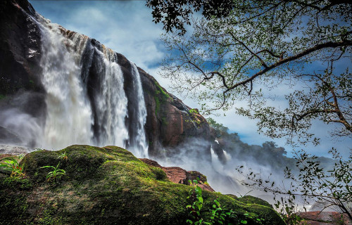
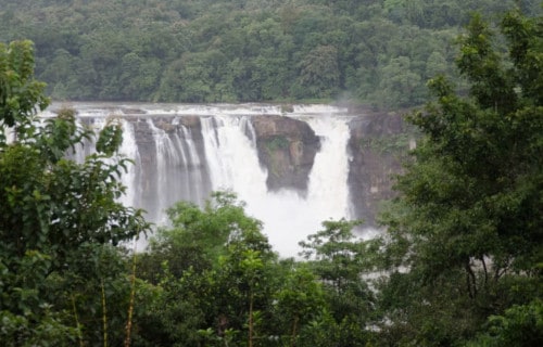
Athirapally Falls
CCL: http://bit.ly/2zBWbKi
Athirapally Falls Facts
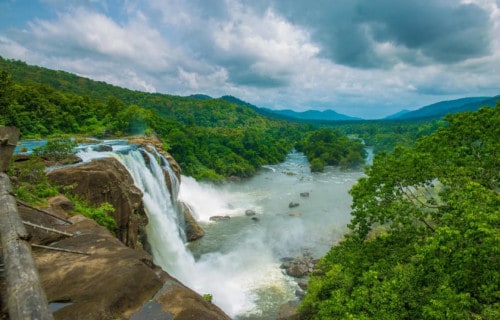
- Next among our selection of Earth’s Many Stunning Waterfalls comes the little-known beauty of Athirapally Falls.
- This natural wonder forms a rather picturesque marvel situated in Athirapally Panchayath, in Thrissur District of Kerala. This sits on the southwestern coast of India, in Asia.
- This waterfall is also located on the west-flowing Chalakudy River, near the Vazhachal Forest Division and the Sholayar ranges.
- This picturesque 80 ft (24 m) waterfall and the nearby Vazhachal Falls remain extremely popular tourist destinations. Athirapally Falls has also been nicknamed The Niagara Falls of India.
- Yet, controversy about a state-proposed hydroelectric dam on the Chalakudy River, at a spot above the waterfalls, began in the 1990s and continues on to this day.
CCL: https://bit.ly/3xiftQo
Athirapally Falls Source and Course
Athirapally Falls draws its water from the rather impressive 90 mi (145 km) long Chalakudy River. The river originates in the Anamudi mountains of the Western Ghats.
It then flows through the Vazhachal Forest toward the Arabian Sea. As a result, the river initially runs smoothly yet quickly becomes more turbulent as it nears Athirapally.
At Athirapally Falls, the water also surges around large and numerous rocks and cascades down in three separate plumes. Below the falls, the river remains rather turbulent for a distance of approximately 0.6 mi (1 km), until it reaches Kannamkuzhi.
At that point, it calms significantly and consequently flows smoothly until reaching the dam at Thumburmuzhi.
CCL: http://bit.ly/2xLZ0ap
Athirapally Falls Ecology
The Athirapally Falls themselves represent a beautiful example of Nature. Yet, they represent only part of the natural splendor of the region.
Forest wildlife in the area includes the Asiatic Elephant, tiger, bison, sambar, and the lion-tailed macaque. The unique 590 ft (180 m) elevation of the riparian forest in the Athirapally-Vazhachal area is also the only location where all four South Indian species of hornbills are found dwelling together.
These bear the names of the Malabar Pied Hornbill, the Great Hornbill, the Indian Grey Hornbill, and the Malabar Grey Hornbill.
Plantations in the region also contain great quantities of teak, eucalyptus, and bamboo. The river also provides a habitat for 85 known species of freshwater fishes. Among these, 35 are endemic species.
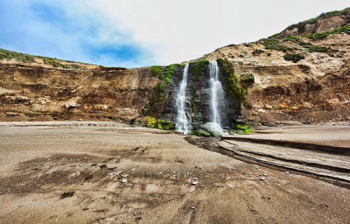
Alamere Falls
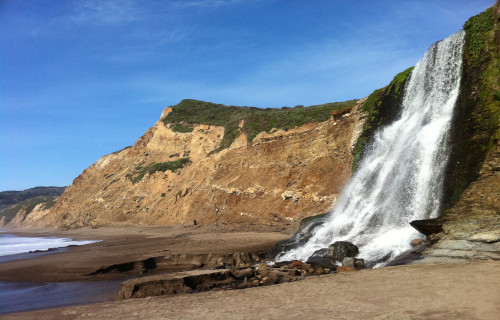
CCL: https://bit.ly/3hpOKfc
Alamere Falls Facts
- Now, the eleventh location included in the article on Earth’s Many Stunning Waterfalls, Alamere Falls, is an extremely rare kind.
- Firstly, this site forms a remarkably beautiful and unique waterfall. This geological masterpiece lists as a type of waterfall known as a tidefall.
- This truly remarkable and visually stunning fall forms one of only two in the region. In fact, very few of this type exist anywhere in the world.
- The falls may only be reached by land via the Coast Trail. The terrain leading to Alamere Falls from above stays comparatively rugged.
- Consequently, the rather rugged nature of the area also makes the location a popular one for hikers. However, caution remains advised when attempting it.
CCL: https://bit.ly/3jW6lgB
Alamere Falls Geography
Though the lowest section of Alamere Falls garners all the attention, this unique waterfall formed as a multi-tiered one. It consists of a total of 4 drops in all.
Each of the upper three falls drops roughly 10 ft (3.1 m) in height. The lowest drop measures roughly 40 ft (12.2 m) high, giving the waterfall a total drop of about 70 ft (21.3 m).
The waterfall sits on Alamere Creek. The water flows throughout the year. The final drop of falls flows directly onto the beach and then flows directly into the Pacific Ocean.
During periods of high tide, the flow from the falls will drop directly into the ocean, making for a once-in-a-lifetime viewing opportunity.
CCL: https://bit.ly/3hsLu2T
Alamere Falls Location and Nature
The incredibly beautiful and unique Alamere Falls sits within the confines of the Point Reyes National Seashore, in Marin County, California, in the United States.
By its very nature, this truly magnificent site remains the rarest type of cascade in the world. Many also consider the type to be among the most beautiful.
From land, the site can only be accessed by undertaking a moderately arduous hike of roughly 2.5 miles (4 km). The same hike also passes by two rather small lakes.
The gorgeous waterfall itself draws the entirety of its water from the similarly-named Alamere Creek, which winds through the area.
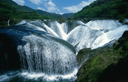
Pearl Shoal Waterfall
Pearl Shoal Waterfall Facts
- Now this gorgeous cascade, the amazing Pearl Shoal Waterfall, absolutely deserves mention in any listing of Earth’s Many Stunning Waterfalls.
- Most notably, the breathtaking waterfall remains considered by many to be the most beautiful waterfall in its region.
- In fact, this fabulous marvel of Nature formed within what now constitutes the confines of the Jiuzhaigou Nature Reserve.
- Rather understandably, given the beauty of this waterfall, and other features, this fabulous corner of the world is well-known.
- In addition, due to its great natural beauty, the Reserve represents both a World Heritage Site and a World Biosphere Reserve.
Public Domain Image
Pearl Shoal Waterfall Physical Description
The gorgeous Pearl Shoal Waterfall does not rank as large in terms of width, but it does, however, have a rather large width.
Its top has an average width of about 550 ft (163 m), although that changes somewhat as rainfall amounts in the region vary.
In addition, its drop measures around 130 ft 940 m), but the dimensions of the cascade are not the primary source of its beauty.
Finally, as it descends, the water flows over a series of uniquely placed outcroppings. This creates an incredible interlocking pattern of flows.
Pearl Shoal Waterfall Location and Ecology
The magnificent Pearl Shoal Waterfall formed in Asia, in what now constitutes Sichuan Province, in China, to be exact.
Furthermore, and perhaps, fortunately, this mesmerizing waterfall sits in a region that has been set aside as the Jiuzhaigou Nature Reserve.
It also represents a small portion of the Yangtze River system that has a vital impact on the region that it flows through.
The water flowing over the falls remains extremely rich in minerals, such as calcium carbonate, which gets deposited in quantity.
Finally, this mineral build up is so strong that allows plants and even small trees to actually grow within the middle area of the falls themselves.
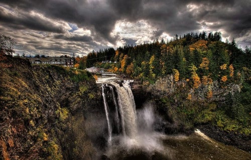
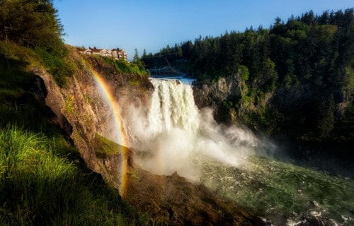
Snoqualmie Falls
CCL: https://bit.ly/1jxQJMa
Snoqualmie Falls Facts
- Including the magnificent Snoqualmie Falls within this compilation of Earth’s Many Stunning Waterfalls was an easy decision to make. It places thirteenth only due to random selection.
- Firstly, the gorgeous waterfall remains a natural masterpiece. The site also easily qualifies as one of those marvelous works of Nature that few people know the name of, outside its local region.
- However, within the country it formed in, it remains an extremely popular tourist site. Due to this fact, more than 1.5 million tourists visit the truly magnificent location annually.
- Yet, while few may know its name, many have seen images of it. This holds true because the location gained a measure of international notoriety in 1990. Producers used it as a backdrop in the cult classic TV series, Twin Peaks.
- Finally, officials named this stunning waterfall to the National Register of Historical Places, in 2009. This occurred due to its importance in the beliefs of the local Native American Snoqualmie Indian Tribe.
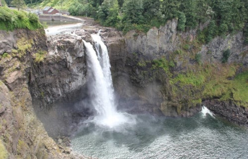
Snoqualmie Falls Physical Description
Most notably, the breathtaking Snoqualmie Falls has an average plunge of roughly 268 ft (82 m). Further, the marvelous site sits at an elevation of approximately 395 ft (120.4 m).
Sadly, much of the river is diverted for hydroelectric generation, yet enough flows over the falls to create an incredible sight. The plunging water generates an almost continuous, and rather impressive, quantity of spray.
The width of the waterfall, however, varies somewhat significantly. This occurs due to the occasional influx of locally heavy rainfall, or melting snow in the region.
In addition, the waterfall presents a small, lesser-known feature. This is located just to one side, as seen in the picture here. A small opening at the base of the rocks, off to one side, pours forth a small, second flow of water.
CCL: https://bit.ly/1eBd9Ks
Snoqualmie Falls Location and Importance
Firstly, the mesmerizing Snoqualmie Falls formed in what is now the northwestern part of the continental United States, in North America. Further, it sits about 25 mi (40 km) from the city of Seattle, Washington.
For centuries, the site played a rather pivotal role in the lives and beliefs of the Snoqualmie Indians. Due to this, the location formed the site of a sacred burial ground, and was central to their religious beliefs and culture.
But, in 1899, a power plant was built 270 ft (82 m) underground, that operated at the base of the falls. That power is still in operation today. Furthermore, it represented the first entirely underground power plant ever built.
In addition, the site now serves as the centerpiece of a large, beautiful National Park. Hiking in the region also serves as a popular pastime for many. Yet, despite the constant flow of people, many animals still call the area home.
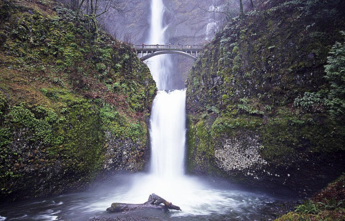
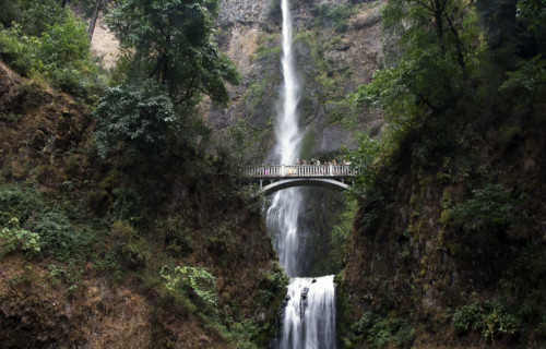
Multnomah Falls
CCL: https://bit.ly/1E6HPMf
Multnomah Falls Facts
- The next of our choices for inclusion in this article on Earth’s Many Stunning Waterfalls is the gorgeous Multnomah Falls.
- Most notably, the breathtaking site remains another of those stunning natural features that few people outside of its region known of. However, in that region it is one of the most often visited tourist sites in that area.
- Further, to facilitate the enormous volume of foot traffic, observation decks have been constructed in several locations. Thus, with the greater ease of access, more than two million people visit the wonder of Nature each year.
- Local Native American tribes knew of the site for centuries prior to the arrival of outside explorers. The Lewis and Clark expedition, in 1805, became the first known non-indigenous individuals to discover the gorgeous site.
- Also, the waterfall itself derives its name from one local group the Multnomah. The location also held great significance to the members of the tribe, including forming part of their mythology.
CCL: https://bit.ly/1eBd9Ks
Multnomah Falls Physical Description
First of all, the magnificent Multnomah Falls ranks as the tallest waterfall in its area. That’s because the awesome two-tier fall has an overall height of roughly 620 ft. The upper section comprises the majority of that, however.
That upper section measures a total of about 542 ft (165 m) in height. Meanwhile, the lower section only measures a total of 69 ft (21 m). Additionally, a small decline of 9 ft (3 m) separates the two sections.
Despite its height, the feature has a rather narrow width. In fact, this averages on 10 ft (3.05 m) throughout most of the year. Finally, these factors combine to provide it with an average flow rate of 150 cu ft/s (4.2 m3/s).
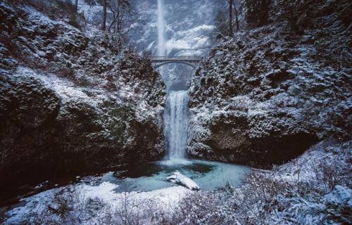
Multnomah Falls Location, History, and Formation
Firstly, the awe-inspiring Multnomah Falls formed in what now constitutes the state of Oregon, in the United States, in North America. Visitors can access the natural wonder via the Historic Columbia River Highway.
In addition, geological evidence indicates that this marvelous cascade originally formed about 15,000 years ago. This occurred as a result of the gargantuan Missoula Floods, at the end of the last ice age.
But, separating it from the majority of other waterfalls is the primary source of its water. Unlike most similar features, it doesn’t have runoff or rain as its major source. Although these do add to the flow, most of its water originates in underground springs.
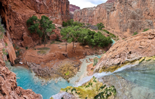
Havasu Falls
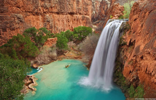
CCL: https://bit.ly/2GS08gY
Havasu Falls Facts
- Placing 15th among our choices of Earth’s Many Stunning Waterfalls comes the staggeringly beautiful Havasu Falls.
- Without doubt, the mesmerizing cascade easily ranks as one of the most beautiful waterfalls in the world. It also goes by the name of Havasupai Falls. By either name, it also remains one of the most difficult falls in the world to access. But, that fact serves to provide it with at least a measure of protection, to preserve it in its natural state.
- But, two specific factors serve to limit access to this marvel of Nature. Most notably, the site sits on tribal land belonging to a small group of Indigenous Peoples. The tribe strictly regulates the number of visitors to the location. Access to the site remains limited to those acquiring a permit from local authorities.
- In addition to this requirement of man, the very nature of the surrounding terrain also serves to make it difficult to access. The local topography makes it nearly physically impossible to gain access to the site from the ground, without the knowledge of the indigenous inhabitants of the region.
- However, its sheer natural beauty gives this wonder of Nature a powerful allure. This has garnered the site international attention several times, in some ways. With the permission and cooperation of local authorities, its beauty has been featured in both a Hollywood movie, and a music video.
CCL: https://bit.ly/31kFWh4
Havasu Falls Physical Description
Most notably, the fame of the truly stunning Havasu Falls derives purely from its natural beauty. This notoriety, although certainly well-deserved, has no basis in its physical size. This holds true due to the fact that the waterfall represents no more than an average sized cascade. This pertains to both its height and width.
First of all, the waterfall itself consists of a single stage, much like the vast majority of similar features scattered throughout the world. In its case, the water plunges a total of about 100 ft (30 m). It also does so over a series of several vertical cliffs. These cliffs have a composition primarily consisting of dark reddish sandstone.
But without a doubt, the most visually striking feature of the gorgeous Havasu Falls remains the breathtaking color of the water itself. The underlying rock strata contains high concentrations of calcium carbonate. This distills into the flow, providing the water with an astounding aquamarine color.
Havasu Falls Location, Formation, and History
Quite surprisingly, the gorgeous Havasu Falls sits within another larger, and far better known, natural marvel. That other wonder of Nature is none other than the Grand Canyon itself. The waterfall, therefore, formed in what now constitutes the state of Arizona, in the United States. Along with the canyon, this waterfall forms another of the great natural wonders of North America.
The stunning cascade formed on what became tribal land of the Native American tribe, the Havasupai. The tribe has lived at the site for more than 800 years. This astonishingly beautiful cascade formed through a combination of two processes. These consisted of both slow erosion over time, and rapid erosion due to the occurrence of flash floods in the area.
Furthermore, the high levels of calcium carbonate in the water also leaves deposits as it flows along. Over time, these minerals built up in several places, forming small but magnificent travertine steps. However, the frequent flash floods in the region often changes these. Sometimes one or more becomes reduced due to the force of the flood, or even demolished, to be reformed later.
In addition, because of the occurrence of the same flash floods, the nature of the waterfall itself often changes. Prior to one especially powerful flood, the waterfall flowed in one broad sheet. It bore the name of Bridal Veil Falls at that time. Since then, the form of the flow has changed on several occasions. Currently, it flows in a single sheet of water, whose temperature remains a near-constant 70 degrees fahrenheit (20 Celsius).
Hogenakkal Falls
CCL: https://bit.ly/2WV7LfJ
Hogenakkal Falls Facts
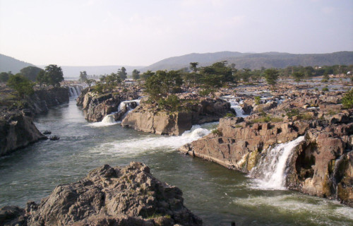
- Next up among our selections for inclusion in this article about Earth’s Many Stunning Waterfalls is the visually remarkable Hogenakkal Falls.
- Firstly, the incredibly stunning natural formation represents a particularly distinctive and ruggedly beautiful waterfall. In the language of the region this name means smoking rock. This magnificent example of the variety of nature also goes by another name. That’s because the local inhabitants also refer to it as Marikottayam.
- Secondly, this marvelous site has long played an important role in the culture and life of the inhabitants of the region. For starters, that’s because of the fact that it has long served as a site for bathing. In addition, the amazing site also now plays a vital economical role in the area. This holds true due to the fact that it now constitutes a popular tourist attraction.
- Finally, the fabulous Hogenakkal Falls also hold yet another role of importance in the area in which it formed. This occurs because of a proposal made by the local government. Under this proposal, the falls, sometimes called the Niagara Falls of its region, would be used as a source of drinking water for the inhabitants of the immediate area surrounding the falls.
CCL: https://bit.ly/3auZFP4
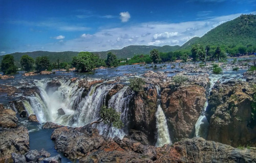
Hogenakkal Falls Physical Description
Perhaps most notably, the sincerely breathtaking Hogenakkal Falls has a truly unique structure to it. In this manner, this incredibly fascinating site distinguishes itself from the majority of other waterfalls to be found throughout the world. That’s because, instead of a comparatively simple plunge, or group of plunges, it has a decidedly different construction.
That’s due to the fact that it actually consists of a series of channels of varying sizes. Further, these remarkable structures total 14 in all, each with a different pattern. That’s because the drop in height for each channel remains different form the others. Some of them drop no more than 15 ft (4.6 m). Others, however, have a drop measuring as much as 65 ft (19.8 m).
Nevertheless, the most distinctive feature of the remarkable Hogenakkal Falls remains the rocks through which it flows. That’s because these unusual formations have a fascinating composition. Composed of carbonatite, these play an important role in the distinctiveness of the site. This holds true due to the fact that these structures are some of the oldest rocks on the continent.
CCL: https://bit.ly/3auZFP4
Hogenakkal Falls Location, Source, and Importance
The supremely mesmerizing natural formation known as Hogenakkal Falls formed in an area of the world that remains well known for its incredible natural beauty. That’s due to the fact that the cascade formed in what now constitutes the country of India, in Asia. More precisely, the remarkable waterfall sits about 79 mi (127 km) from the city of Bangalore in Karnataka.
In addition, located in the southern portion of the country, the incredible cascade formed on a section of the Kaveri River. Furthermore, the exact spot on which the stunning work of Nature sits actually borders two separate districts of the vast country. The two distinct areas within whose boundaries it lies are the districts of Chamrajnagar and Dharmapuri.
Also, the locally important river itself originates near a site known as Talakaveri. This particular location has long been considered a holy site by the local populace, and sits in the Western Ghats. From there, it quickly gathers force as it drops in elevation. Also, numerous small tributaries add to its volume as it flows downward, until it reaches Hogenakkal Falls.
Additionally, along the way, the flow of the water after the cascade carries large quantities of sediment downstream. As it deposits this, it serves to make the land more fertile, allowing for the successful growing of crops. Further on, it spreads out over numerous sandy beaches. Finally, it reaches the Mettur Dam, and forms the Stanley Reservoir, built in the year 1934.
Earth’s Many Stunning Waterfalls
These examples of Earth’s Many Stunning Waterfalls, as well as the countless others around the globe, truly represent some of nature’s most astonishing beauty. Yet these marvels remain fragile.
They must, therefore, be protected and preserved for our posterity to enjoy, just as we now do. It is up to us and our descendants to ensure that they never vanish from the earth. Let us all do our part to ensure they remain with us forever.
Check out our other articles on 6 Mysterious Natural Phenomena, 7 Bizarre and Unusual Birds, 10 Dazzling Denizens of the Depths