


Missouri River Facts
- This majestic flow of water, created over eons of time, most frequently goes by the somewhat deceptive common name of the Missouri River. This wonder does have a few other general titles, though. These tags include the colloquial terms Mighty Mo and Big Muddy.
- However, the beautiful river also holds still other names. These often reflect various historical, geographical, or cultural contexts. Though less known, these still exist within the native tongues of various populations of local Indigenous Peoples, who’ve long known of it.
- The Lakota People call it Mníšoše, which means “The Water of the Big River.” Meanwhile, in the original language of the Hidatsa People, this geological wonder bears the name “Horse River.” Both the Miami and Illinois tribes, though, referred to it as Peki-tan-oui.
- Archaeological evidence indicates that early humans likely first encountered this marvel of Nature somewhere between roughly 12,000-10,000 years ago. At the end of the last glacial period, large migrations took place, many apparently occuring along its winding path.
- European explorers did not discover the mighty flow until much later, however. The first documented sighting of it by a non-native took place in late June,1673. At that time, the well known French-Canadian explorering team of Louis Jolliet and Jacques Marquette sighted it.
- Today, the mighty Missouri River holds many distinctions. Among those comes the fact that it appears on the list of the seven great rivers of the world. It also stands out as the longest of all rivers in the nation in which it lies. Several areas along its length now enjoy special protection.
Related Articles
Missouri River Physical Description
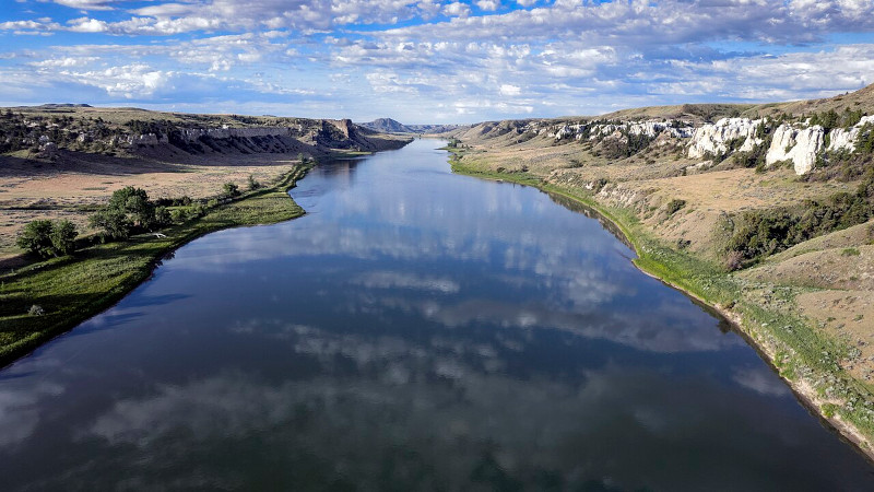
The indescribably impressive Missouri River rarely fails to mesmerize those who view this marvelous work of Nature for the first time. Those who do, though, often find themselves hard-pressed to choose which trait most amazes them. That’s because it’s both beautiful and extensive.
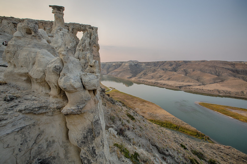
Though certainly not the longest river found on the planet, it’s nonetheless lengthy enough to merit its own respect in this regard. The mighty flow extends for a measured length of approximately 2,341 mi (3,767 km). Along its passage, the wonder incredibly also flows roughly both east and south.
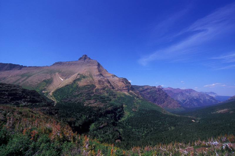
For purposes of clarification, most experts currently divide the river into three distinct regions. The first of these also understandably bears the fitting name of the Upper Missouri. This portion of the river begins in mountainous terrain, characterized by rugged landscapes and narrow valleys.
As it ponderously moves along, the moniker of the second division likewise follows the same pattern of naming. The Middle Missouri flows into the area of the nation called the Great Plains. As it does so, though, it broadens and meanders through wide valleys surrounded by prairies.
The final stretch of the fantastic river naturally holds the title of Lower Missouri. Here, the river flows into yet another of the seven great rivers of the world, the Mississippi River. Approaching that confluence, it passes through fertile agricultural regions and more developed areas.
The Missouri River also traverses a remarkable and highly diverse range of landscapes, including mountains, plains, and valleys. Its basin covers roughly 529,350 sq mi (1,371,000 sq km). This actually equals about one-sixth of the area of the continental part of the nation it resides in!
Historically, the river additionally carried an enormous amount of sediment, therefore earning it the nickname “Big Muddy.” However, the construction of several dams later reduced that. Despite these, its flow nevertheless still varies seasonally, being heavily influenced by snowmelt.
Missouri River Location, Formation, and Ecology
The amazing Missouri River formed in a region of the globe already well known for its impressive abundance of varied geological marvels. The exact location of this beautiful flow therefore likely won’t surprise many readers. Nature created it as part of what’s now North America.
Within that greater region, however, the entirety of its length actually lies completely within the national borders of the United States. Its admittedly rather circuitous course takes it from the approximate northwestern part of the country to slightly the eastern-central section of the country.
The awesome body of water originates in Montana. From there, it flows generally southeast, cutting through the central part of the nation. Along with that state, it passes through or along the borders of six others, including, North Dakota, South Dakota, Nebraska, Iowa, Kansas, and Missouri.
The formation of this work of Nature occurred due to a powerful combination of both complex geological and hydrological processes. This formative process also took place over the passage of many millions of years. In fact, evidence indiactes it dates back to nearly 70 million years ago.
At that time, a large inland sea covered the area that it now claims. This shallow sea gradually retreated as tectonic activity raised the land. The uplift of the Rocky Mountains and other ranges also provided a source of sediment and created a gradient that influenced the direction of flow.
As the majestic mountains rose, though, erosion processes began to irresistably wear them down, with streams and rivers carrying sediments eastward. The eroded material from the Rockies and other areas contributed to the development of extensive alluvial plains and river systems.
During what scientists call the Pleistocene epoch, roughly 2.6 million to 11,700 years ago, multiple glaciation events also played a significant role in shaping the landscape. Glaciers advanced and retreated over the region, carving out valleys and altering the flow patterns of rivers.
The melting of these provided a substantial amount of water, contributing to the river’s flow and helped define its current course. The modern course, however, established itself as the waters cut through the sedimentary plains. Its path additionally shifts over time due to natural processes.
This wonder supports a diverse and complex ecosystem that varies along its length, including a range of habitats from its headwaters to its confluence with the Mississippi River. Its ecology’s naturally shaped by factors such as climate, geology, hydrology, and even human activities.
In its upper reaches, the impressive river flows through numerous montane and riparian habitats, alike, all characterized by cold, clear water. This region further supports a broad variety of cold-water fish species, and the surrounding landscapes include many forests and alpine meadows.
Meanwhile, the middle section of the great Missouri River features large sandbars, islands, and braided channels, which are important for nesting birds and other wildlife. Some of these include the American white pelican, bald eagle, great blue heron, and various ducks and geese.
Near its confluence with the Mississippi River, though, it flows through a notably much more temperate region with a number of mixed deciduous forests, wetlands, and urbanized areas. Yet, it still hosts many other flora and fauna. A few examples include beaver, deer, muskrats, and otters.

Features Sharing Its Region
Check out our other articles on 4 Remarkable Reptiles of Thailand, Wisent, Komodo Island, Bird’s Foot Violet, Tree Bumblebee, Hellbender Salamander, Tiger Shark, Texas Alligator Lizard