


7 Truly Astounding Geological Wonders
Our beautiful world remains filled with wonders of geology to dazzle the mind and senses. These wonders come in all astonishing forms, shapes, and sizes. Some of them stand out, however, for their utter uniqueness. Here, we have attempted to list our choices for 7 Truly Astounding Geological Wonders.
As always, any such list remains highly subjective. What we consider bizarre others may not, and this is completely natural. If you have a few that you think should be on such a list, please let us know. In the meantime, we sincerely hope that you enjoy reading of those on this list.
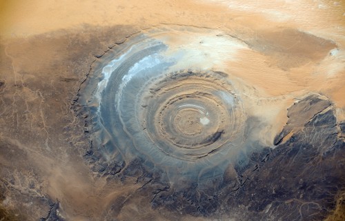
Eye of the Sahara
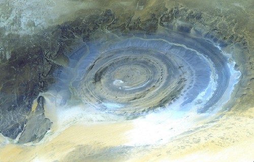
Eye of the Sahara Facts
- The Eye of the Sahara ranks as one of the most incredible geological marvels of our world. This phenomenal site sits in the Sahara Desert in western Mauritania, in Africa.
- This extraordinary geological feature was actually unknown until it was accidentally spotted from space. Between its extreme remoteness and its sheer size, no one noticed its uniqueness, even when passing through it.
- While competing theories concerning its origins exist, the debate still rages among some scientists. Nature seems reluctant to yield its mysteries to mankind.
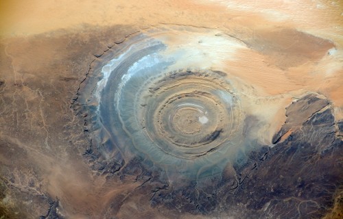
Eye of the Sahara Physical Description
Evidence indicates that the astonishing Eye of the Sahara represents the remnants of a geologic dome that formed approximately 100 million years ago.
It has a rough diameter of 25 mi (40 km). Actually consisting of several concentric rings, the largest, the central area, measures roughly 19 mi (30 km) in diameter.
A wide variety of rock structures appears in the various sections of the Eye, such as volcanic rocks, gabbros, carbonatites, and kimberlites.
Numerous hydrothermal features also exist within the site. These include formations consisting of sandstone, silica, and limestone.
Eye of the Sahara Mysterious Origins
Local people believed that the remarkable Eye of the Sahara was originally the result of a large meteor strike in ages past, but scientific studies have recently disproved that theory.
Also, different types of rock structures make up each of the separate rings. Scientists still have no definitive explanation for that rather surprising fact either.
The truly astonishing site actually remains visible from orbit. Scientists now believe it most likely is the result of the effects of uplift and erosion, although geologists admit that they are not certain about that. The cause of its circular shape remains a mystery.
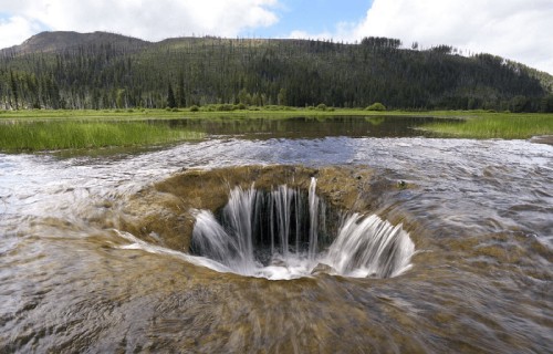
Lost Lake
Lost Lake Facts
- The body of water popular as Lost Lake is a fascinating geological oddity. Each year the entire lake disappears during the winter. However, the disappearance does not occur due to evaporation.
- Routinely, the entire volume of the rather lovely, but otherwise normal-seeming, small lake quite literally disappears down a hole.
- Local Native Americans have long known of the uniqueness of the site. They called the lake Kwoneksamach. European Americans first discovered it in the 1870s.
- This visually rustic, and rather mysterious lake remains quite popular with photographers, as well as being a popular camping site.

Lost Lake Physical Description
The entire region in which Lost Lake now sits comprises part of a rather extensive lava bed which geologists say formed about 3,000 years ago.
The source of the drainage is a lava tube formed during the period of volcanic activity. This surprising lava tube measures roughly 6 ft (2 m) wide.
During the spring and summer, the lake is full thanks to a combination of rainfall and the prodigious volume of runoff from snowmelt in the nearby mountains.
During the winter the inflow ceases, and the water drains away.
Lost Lake Location and Mystery
The small, but truly lovely Lost Lake lies in Santiam Pass, Oregon, in the United States, and forms part of the Mount Hood National Forest.
When present, the remarkable body of water remains a small, shallow, closed-basin lake lying roughly 18 mi (29 km) southwest of Mount Jefferson.
However, do not let the unassuming beauty of this location lull your senses. Scientists have yet to answer one long-standing question regarding the area.
To date, exactly where the water draining from Lost Lake goes remains a mystery at this time. Despite numerous studies and multiple theories, no answer has yet been found.
Nature likes to maintain her secrets.
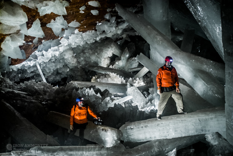
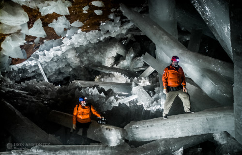
Giant Crystal Cave
Giant Crystal Cave Facts
- The Giant Crystal Cave or Cave of Crystal Giants names a true marvel of geology.
- It sits roughly 1000 ft (300 m) beneath the surface, outside of Chihuahua, Mexico, in North America. The site was accidentally discovered in 2000.
- The proximity of the incredible site to a nearby magma chamber makes it impossible to visit this geologist’s paradise without protective gear.
- In fact, the temperature and humidity are so high that the heat index is 228 degrees Fahrenheit (105 C).
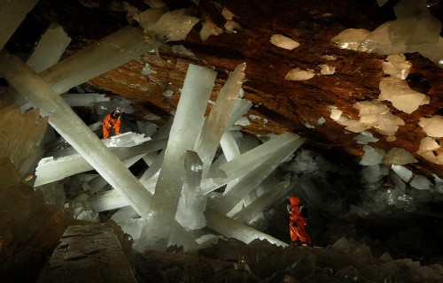
Giant Crystal Cave Description
The Incredible Giant Crystal Cave serves as home to the largest crystals on earth – some as large as 34 ft (11 m) long and weighing 55 tons. They are composed of selenite that a nearby magma chamber deposited over the centuries.
These enormous and impressive crystals formed as a result of heated groundwater being saturated with sulfide ions. Much colder surface water leaked down and contacted the mineral-saturated hot water.
Yet the two did not mix due to the difference in their densities. Hydrated sulfates formed at an extremely slow rate over the course of at least 500,000 years, forming the enormous crystals
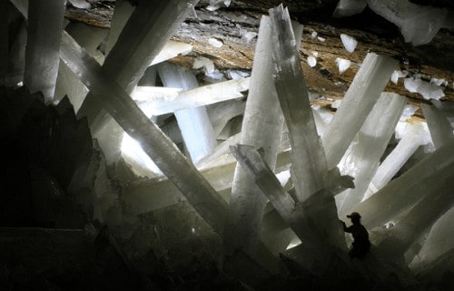
Exploration of the Giant Crystal Cave
Due to the extreme conditions within the Giant Crystal Cave, humans still know very little about it.
The cave has a roughly horseshoe shape and lies within an enormous limestone deposit. Also, faceted crystalline blocks cover the floor, and the enormous crystalline beams protrude through these.
When the cave originally discovered, water filled the inside. The cave is accessible now only because the nearby mining operation which discovered it keeps pumping the water away.
Only authorized scientific researchers have access permits, due to the conditions, and the fact that the crystals have started to slowly deteriorate from exposure to the air.
Kelimutu
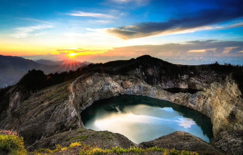
Kelimutu Facts
- Kelimutu stands out as a truly remarkable volcano. This marvel of geology is one of the few known volcanoes with 3 calderas. Plus, each of these holds a lake, and each has different colored water.
- The lakes only partially attain their colors as a result of the activities of the volcano. The volcanic gases emitted by fumaroles in the crater of Kelimutu also interact with chemicals in the water of each lake.
- The colors of the lakes actually change from time to time as a result of random periodic alterations in their chemical composition.
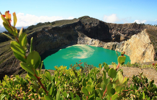
Kelimutu Physical Description
Kelimutu resides at an altitude of 5,377 ft (1,639 m) above sea level. Two of the calderas actually share a wall, while the third sits a short distance to the west. The walls of every one vary in height, with the highest prominence being 157 ft (48 m).
Each caldera boasts a small lake and the waters of each of these present different colors.
The lone lake to the west typically displays blue water, while the two sharing a wall typically display green and red water.
In addition, these colors change periodically and sometimes include brown and black. Geologists consider Kelimutu inactive since the last eruption was in 1968.
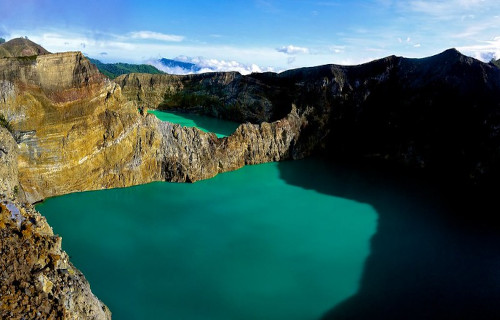
Kelimutu Location and Nature
This marvelous volcano sits on the island of Flores, in Indonesia.
Its summit has become highly elongated by geological forces and now has a roughly rectangular shape. The nearest populated area remains the town of Moni, at 50 mi (80 km) away, even today. Small fumaroles also populate the floors of the calderas.
The volcanic gases released by these fumaroles interact with the various chemicals and minerals inherent to the individual lakes. The resulting colors, therefore, present differently as well.
Despite its remoteness, Kelimutu has become a popular tourist attraction.
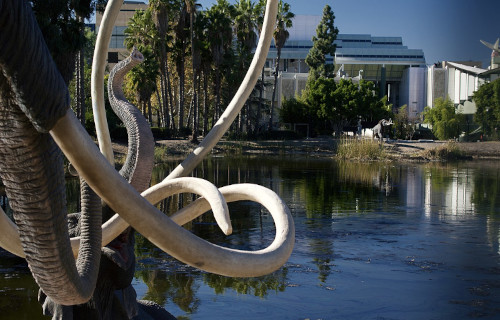
La Brea Tar Pits
La Brea Tar Pits Facts
- The La Brea Tar Pits ranks as an extraordinary and unique geological feature. Incredible as it may sound, they lie within a major metropolitan area in the United States.
- The ancient Native American tribes indigenous to the area knew these well. The Chumash and Tongva tribes used the naturally occurring tar to seal their canoes.
- Over time, countless animals fell prey to the La Brea Tar Pits. Humans subsequently excavated many of those remains, along with preserved specimens of numerous plants and insects. This incredible site, therefore, provides an unparalleled sample of prehistoric life.
- The oldest remains thus far excavated here date back more than 38,000 years. This location indeed serves as a naturally occurring time capsule.
La Brea Tar Pits Composition and Formation
Even though it remains impossible to determine the exact age of the La Brea Tar Pits, evidence shows their age to be at least 40,000 years.
The pits primarily formed from a heavy fraction of oil, and gilsonite. As it seeps to the surface, it cools into variously sized mounds. In many sites, the viscous liquid is quite often (in a seemingly other-worldly manner) bubbling. In fact, this impressively results from naturally occurring methane rising to the surface.
Bacteria living deep within the oil actually generate the methane. Perhaps at least 300 forms of these live within the pits and many of them exist nowhere else on Earth.
La Brea Tar Pits Today
Today, the La Brea Tar Pits serve as both a tourist attraction and a source of ongoing scientific research. They sit within the confines of Hancock Park, which is itself located within the city of Los Angeles.
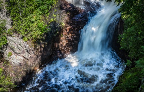
Devils Kettle Falls
CCL: http://bit.ly/2xLZ0ap
Devils Kettle Falls Facts
- The mysterious, not to mention appealing, Devil’s Kettle Falls constitutes an almost unknown natural wonder. It also remains a mystery that still defies explanation. And who doesn’t love a good mystery?
- This unique waterfall known as Devil’s Kettle Falls remains a central part of the Judge C.R. Magney State Park. It is situated in the state of Minnesota, in the United States.
- The waterfall forms part of the final stages of the Brule River, as it approaches Lake Superior. It is here that a mystery occurs that remains unexplained to this day. Do you find yourself intrigued yet?
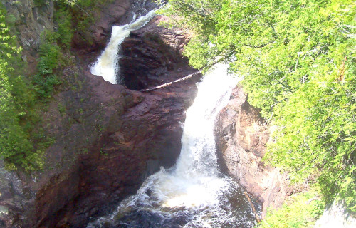
Devil’s Kettle Falls Geology
To the naked eye, the Geology of Devil’s Kettle Falls seems unremarkable, though certainly pleasing to the eye.
The waterfall occurs roughly 1.5 mi (2.4 km) before the end of the Brule River. The river drops an impressive 800 ft (244 m) over the course of only 8 mi (12.8 km), before flowing over a unique waterfall.
This flow gets divided by an outcropping of rhyolite (a volcanic rock). Its eastern section plunges nearly 50 ft (15 m) down a two-stage cascade. However, the other portion holds the beginning of the mystery.
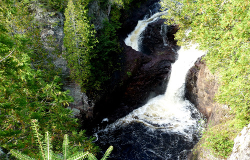
Devil’s Kettle Falls Mystery
The unexplained phenomenon we call Devil’s Kettle Falls began perplexing mankind even before the first Europeans arrived on the continent. The Native Americans knew it well.
On the western side of the waterfall, the water swirls down a large hole in the rock. This hole measures approximately 10 ft (3 m) in diameter. No investigator, professional or amateur, has ever been able to determine.
It was once assumed it flowed into a subterranean river, into nearby Lake Superior. However, scientists have investigated, sending everything from ping pong balls to dye, to sensors down the flow.
No sign of any of these has ever been detected anywhere in the world, proving that Nature still keeps her mysteries.
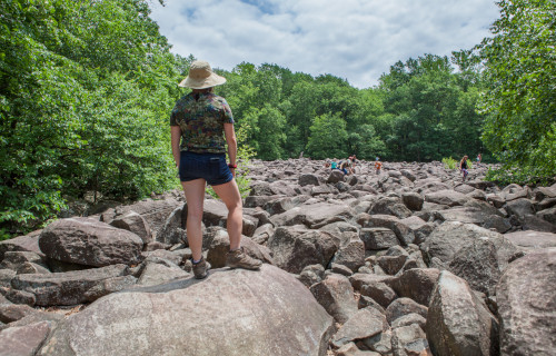
Ringing Rocks

CCL: https://bit.ly/3kfd8Cn
Ringing Rocks Facts
- Ringing Rocks represents proof that our beautiful world still harbors many mysteries, both large and small. This still unexplained conglomeration of stones forms one of those.
- This wonder of geology is a small (but no less mysterious for its size) field of boulders. It formed in what man now call Bucks County, Pennsylvania, United States. The field lies situated near the top of a hillside in what now forms a local park.
- When one strikes the rocks with a hammer or even another rock, a strange phenomenon occurs. At that time, some stones actually make a ringing sound, as if they were hollow, but they are not
- Despite numerous scientific studies of the stones comprising the Ringing Rocks, the cause of the effect is a complete mystery.
CCL: https://bit.ly/2T5pe5O
Ringing Rocks Physical Description
Part of the mystery of the Ringing Rocks surrounds the fact that there is nothing particularly rare or unique about their composition itself. Perhaps this demonstrates that we still have much to learn.
The various sized boulders that form the Ringing Rocks are composed of a substance known as diabase. This remains basically just volcanic basalt.
The time of the volcanic eruption which must have spewed them forth (since there is no indication that they were deposited by glacial activity) remains unknown.
They also contain high concentrations of aluminum and iron. Though it still remains theoretical, scientists believe that they broke apart during the Pleistocene Epoch, approximately 12,000 years ago. This could have occurred through repeated cycles of freezing and thawing.
Photo: Bureau of Land management
CCL: https://bit.ly/36nvRDq
Ringing Rocks Mysterious Nature
The mysterious nature of the Ringing Rocks is not limited to just the fact that the ringing itself remains completely unexplained. There are other mysteries surrounding the formation (Nature never fails to surprise us). A few of these include:
- Not all of the stones ring when struck! Only a percentage of the stones exhibit the unique property.
- The boulder field is relatively expansive. It covers an area of approximately 7.7 acres (3.5 hectares) to an average depth of 10 ft (3 m).
- Boulder fields on a hillside form at the bottom of the hill, as the result of slides. This one, however, sits near the top of the hill. How it could form there is yet another mystery.
- Though the surrounding area is thickly wooded, there is no sign of animal activity around the Ringing Rocks themselves.
- Despite the countless trees in the forest immediately adjacent to the boulder field, not one leaf ever seems to settle onto the boulder field.
- Though the field has been there for at least 12,000 years, only a small handful of weeds (following the outer periphery only) has appeared among the crevices of the stones.
The fact that science has been unable to explain any of these mysteries has led many to suggest that a paranormal explanation may lie behind the phenomena. Regardless of what the explanation is, it can not detract from the beauty and mystery of the place.
CCL: https://bit.ly/2SOHb8z
7 Truly Astounding Geological Wonders
The beauty, and occasionally mystery, of the earth, still amazes us. These 7 Truly Astounding Geological Wonders represent only a tiny fraction of the wonders and marvels our world holds for us. They exist everywhere we turn if we only take the time to look and see them. But such things remain vulnerable to destruction. It falls to us to protect and preserve them, just as it does for the various species around us.
Check out our articles on other wonders of geology, including Nyiragongo Volcano, Fantasy Canyon, Bloody Hell Pond