


CCL: http://bit.ly/2IjEG4n
We sincerely hope that you enjoy this reading article about 5 Geological Marvels of California as must as we enjoyed writing it. Obviously, these represent only a few of the natural wonders to be found in this part of the world, but we think they’re a good sampling.
The sheer variety of the wonders of Nature in this region of the Earth, including the geology, staggers the mind. No matter what manner of such natural features one prefers, most people will find numerous sites to visit, explore, and marvel at here. So enjoy!
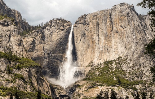
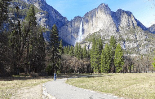
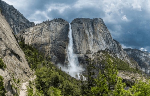
Yosemite Falls
Yosemite Falls Facts
- Leading off this article about 5 Geological Marvels of California comes the breathtaking site known as Yosemite Falls.
- The truly magnificent and often breathtaking feature with the simple name forms the highest known waterfall in its part of the world. Although beauty remains relative, many also consider it one of the most beautiful features of its kind.
- This astounding work of geological forces also now forms a principal part of the Yosemite National Park. It comprises one of the key attractions of the park, in fact, especially in the spring, when the water flow usually reaches its peak levels.
- This wonder of Nature has also played an important role in local history. The base of the gorgeous formation once served as the location of the main village of the indigenous Native Americans of the valley, named the Ahwabneechee tribe.
- The comparatively quite large plunge pool at the base of the waterfall served as a central component of their lives, as well as their mythology. In their native language, the original name for what’s now known as Yosemite Falls was Cholock.
- Given its great natural beauty, this incredible location currently represents one of the most popular tourist attractions in the National Park. In fact, an astonishing average of 4 million people visit this park, and this cascade, each year.
Yosemite Falls Physical Description
While the marvelous visual appeal of Yosemite Falls doesn’t depend on sheer height alone, that characteristic nonetheless remains quite impressive. The total measured height of the stunning waterfall actually measures roughly 2,425 ft (739 m).
The breathtaking site further constitutes what’s known as a multi-tiered waterfall, being, in fact, composed of three primary divisions. These distinct, be equally remarkable, sections, man now calls the Upper Fall, the Middle Cascade, and the Lower Fall.
Purely by itself, the mind-blowing section logically named the Upper Fall plunges approximately 1,430 ft (440 m). This portion alone stands apart as one of the twenty highest waterfalls on earth. The forces of nature, however, did not merely stop there.
The Middle Cascades account for drop of 675 ft (206 m). This section actually comprises five smaller, individual falls. The Lower Falls drop the final 320 ft (98 m), while the large plunge pool at its base remains surrounded by a highly treacherous jumble of talus.
CCL: https://bit.ly/1p2b8Ke
Yosemite Falls Location, Distinctiveness, and Dangers
The truly gorgeous Yosemite Falls justifiably remains considered one of the most beautiful sites in its region. This geological beauty lies situated within the Sierra Nevada mountain range, in California, in the United States, which lies in North America.
Each year, unless rainfall totals in the surrounding region surpass the usual, a most surprising event occurs. To the amazement of those who experience it, the usually impressive flow of water ceases entirely during either the late summer or fall.
Rock climbers occasionally take this opportunity to scale the normally inaccessible rock face at this time. However, this remains extraordinarily dangerous. One scattered thunderstorm could send a surge of water over the falls, plunging the climbers to their deaths.
The local Ahwabneechee tribe hold a very specific legend concerning what’s now known as Yosemite Falls. According to that belief, the plunge pool at the base of the falls is inhabited by the spirits of several witches, collectively known as the Poloti.
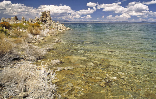
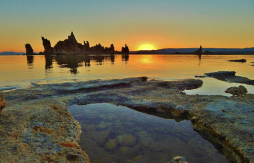
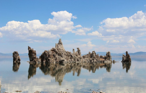
Mono Lake
CCL: http://bit.ly/2N3jmAM
Mono Lake Facts
- Next up among these choices for inclusion in this listing of 5 Geological Marvels of California is the fabulous Mono Lake.
- The relatively simple term for the site represents the name of a particularly impressive, and quite distinctive, body of water. Despite the comparative harshness of the surrounding environment, the site has a unique form of beauty all its own.
- The formation also has a highly unique history, extending far back into antiquity. In more modern times, ancient Native Americans, especially the Kutsadika’a tribe of the Paiute Nation, knew of and lived around the truly remarkable site.
- Much later, European explorers later discovered it while venturing into the area in the 1880’s. At that time, Edward S. Dana and Israel C. Russell provided the first recorded description of the lake and some of its extremely unique geological formations.
- Beginning in the year 1913, however, the city of Los Angeles began diverting water from the lake. This action had the unfortunate, but not surprising, effect of threatening the fragile and unique alkaline ecosystem existing there.
- Later, though, in 1994, a wonderful win for the environment and those who support its preservation occurred. At that time, a newly strong conservation movement succeeded in halting any further diversion of the remarkable waters of Mono Lake.
- Since that time, water levels have begun to slowly climb back toward historic levels. They’ve not yet reached them, though. As a result, exposed shorelines continue to be a source of alkaline dust that can be carried aloft by strong winds in the region.
CCL: https://bit.ly/2Vmlg6y
Mono Lake Physical Description
The eerily beautiful Mono Lake actually forms part of a large basin with no outlet to the ocean. This basin originally formed via the actions of geological forces that took place over the past five million years. The lake itself formed approximately 760,000 years ago.
The steady runoff from enormous salt deposits in the region has made this body of water extremely alkaline in nature. The site also continues to remain somewhat geologically active, with the most recent eruption occurring just over 350 years ago.
That eruption further formed another remarkable feature within the lake itself. That’s a small island bearing the name of Paoha Island. But is marvels do not end there, since numerous amazing limestone towers appear all along the perimeter of the incredible lake.
Mono Lake also boasts some impressive physical statistics. Presently, the site covers an area of roughly 70 sq mi (181 sq km). Its maximum depth currently sits at nearly 600 ft (183 m), and the surface sits at an altitude of 6,380 ft (1,945 m) above sea level.
CCL: https://bit.ly/2VnJ6yJ
Mono Lake Location and Ecosystem
The eerily magnificent body of water known as Mono Lake formed in an area of the world already well known for its geological splendor. To the surprise of many, given its unique nature, the lake formed in what now constitutes California, in Mono County.
More precisely, this itself forms a state in the United States, in North America. This fact may surprise many people, given the standard image of that region of the country. However, the area also has some desert regions, one of which serves as home to this site.
Despite being part of a desert environment, Mono Lake serves as home to a thriving ecosystem. Fish cannot live in these waters, but Nature adapts. At the heart of this astonishing system is the presence of a vast population of a diminutive brine shrimp species.
These actually represent an indigenous creature that actually thrives in the lake’s alkaline waters. These tiny crustaceans, which measure about the size of a fingernail, remain inedible to humans. Numerous shorebirds, however, easily and frequently thrive on them.
An enormous volume of microscopic algae also lives in the lake, sometimes creating a dramatic effect. The presence of such a quantity of algae has the unfortunate effect of occasionally turning it bright green in color. The native crustaceans feed on the algae.
The enormous quantities of these invertebrates, numbering as many as six trillion, populate the lake and provide an essential food supply for many shorebirds during their migrations. Each year, as many as two million of them pause at Mono Lake to rest and feed.
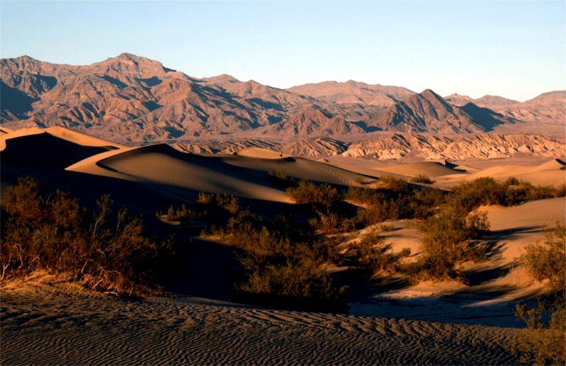
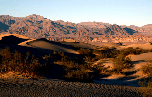
Death Valley
CCL: http://bit.ly/2IjEG4n
Death Valley Facts
- Taking the third spot in this compilation of 5 Geological Marvels of California, though only due to random selection, is the iconic Death valley.
- The term appropriately serves as the name of a severe desert valley. In addition, this marvel of Nature is located in an entirely surprising part of the world. That holds true because it formed in what’s now Eastern California, in the United States.
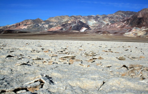
- Its unique geology helps to make it one of the most astounding of such sites in the world. This makes it the driest, lowest, and hottest region found in North America. This stunning location itself contains features completely unique to this part of the globe.
- Among them sits an area that holds a place in the record books. That’s the highly appropriately named Furnace Creek. That’s due to the fact that, in this location, in 1913, the highest air temperature ever recorded was reached; 134 F (56.7 C).
- Yet another feature found within Death Valley holds a prominent position, at least in scientific circles. This region is known by the unusual name of Badwater Basin. It has the lowest elevation in North America, at 282 ft (86 m) below sea level.
- Further, its dangerous, but stark, beauty, has served it well. The desert region currently forms the cornerstone of the remarkable Death Valley National Park. This, in turn, comprises part of the Mojave and Colorado Deserts Biosphere Reserve.
CCL: http://bit.ly/2IjEG4n
Death Valley Geology
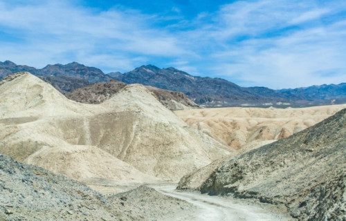
Death Valley remains considered to be one of the finest examples of its type of feature in the world. The area classifies among scientists as a basin and range configuration. The incredible area also sits at the extreme southern end of a trough known as Walker Lane.
This trough, itself quite impressive, proceeds north into the state of Oregon. The magnificent valley also remains bisected by a slip fault system. Furnace Creek also flows into the remarkable valley. Eventually, however, this dries up in the sands of the valley floor.
Quite noticeably, extensive areas of sand dunes also cover large portions of the Death Valley. In addition, numerous features known as salt pans are also located in the region. These form the remains of several inland seas that were present during the Pleistocene era.
The evaporation of these ancient seas also left behind an extremely impressive legacy. Their departure deposited large quantities of sodium and borax This long-term process also left behind large quantities of the minerals sodium and borax.
CCL: http://bit.ly/2IjEG4n
Death Valley Climate
The astounding feature aptly known as Death Valley fully earns its name. That’s due to the fact that it possesses a quite extensive subtropical, hot desert climate. This climate remains categorized by its long, extremely hot summers, followed by very short warm winters.
Furthermore, rainfall stays scarce and sporadic throughout the entirety of the region. More precisely, such moisture continues to be virtually non-existent in some portions of the site. Also, when the sun heats the air, what little does arrive evaporates with extreme speed.
The high valley walls also help add to the climate of the region. These structures efficiently serve to circulate the hot air back down to the floor of the valley. There it quickly becomes heated to even higher temperatures by the process of compression.
In addition to this, yet another condition adds to the situation. The density of the below sea level air further augments the already powerful process. It accomplishes this by reflecting even more of the already overwhelming heat downwards, back into the valley.
Public Domain Image
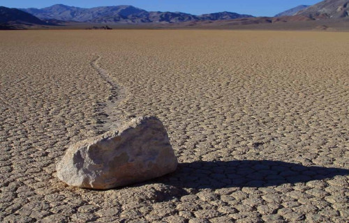
Death Valley Phenomenon
Death Valley also serves as home to a unique phenomenon that had baffled scientists since the 1940’s. Many referred to this as the sailing stones. In a remote region of the valley, known as Racetrack Playa, numerous stones of varying sizes litter the sandy floor of the playa.
Over the decades many of these stones appeared to move, leaving tracks in the sand. These also left behind no apparent explanation. Finally, in 2014, a team of researchers managed to catch the phenomenon in Death Valley in action, and explain it.
Under a rare and unique combination of conditions during the winter, thin sheets of ice form on the floor of the playa. Winds drive the stones slowly across the playa floor, as the ice also breaks up. The process also occurs rarely, and too slowly to be viewed by the naked eye.
New Year’s Island
CCL: http://bit.ly/2RcCTlc
New Year’s Island Facts
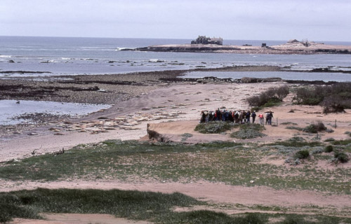
- Our next selection to add to this listing of 5 Geological Marvels of California is the surprisingly important New Year’s Island.
- To the great surprise of many people, this small, in some ways unremarkable location actually forms one of several in the world bearing precisely the same name. This unusual fact, however, appears to have been entirely coincidental.
- It remains unverified if ancient Native Americans knew of its existence, but remains quite likely. In modern times, the first known sighting of the location took place in 1769, and happened as part of a Spanish expedition exploring the area.
- Despite its extremely tiny and seemingly barren surface area, the site also plays a surprisingly important role in its region. This occurs due to the fact that the spot conveniently serves as an important breeding site for many species of animals.
- The original name for the island, in Spanish, is Ano Nuevo Island. Fortunately for those who value its importance to wildlife, it also now forms part of the Ano Nuevo State Reserve. This luckily provides the local creatures with some protection.
- As part of ongoing efforts to protect New Year’s Island, access to it remains restricted to members of approved research teams. In addition, an ambitious restoration project began in 2010, partly to restore native plants to the site.
New Year’s Island Physical Description
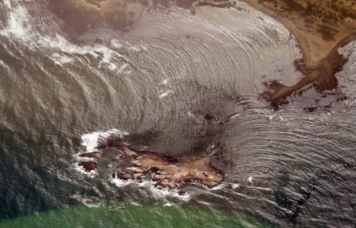
Regardless of its great ecological importance, the surprising New Year’s Island actually only has an extremely tiny total area. In point of fact, this relatively vital, yet little-known location only encompasses an area measuring about 392,000 sq ft, or 9 acres (3.6 ha).
It hasn’t always held this shape, however. Amazingly, up until the 18th century, the island still existed as a peninsula. Over time, though, a channel formed, which eventually resulted in its being separating it from the mainland, where it remains today.
A combination of shale and deposits from ancient dunes primarily makes up the composition of the site known as New Year’s Island. Its exact shape changes slightly quite often, though. Waves pound its soft shoreline, especially during strong storms.
CCL: http://bit.ly/2xLZ0ap
New Year’s Island Location and Ecological Importance
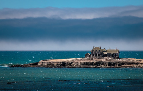
The surprisingly ecologically important New Year’s Island formed in a part of the world already well known for the majesty of its natural formations. More precisely, the wonder sits just off the northern coast of California, in the United States, in North America.
To ensure its protection, the island is also managed under an agreement with the California Department of Parks and Recreation. Somewhat uniquely, perhaps, the actual management is carried out by the California Department of Parks and Recreation.
This admittedly visually unimpressive island nevertheless holds great importance. In fact, it has long served as a vital breeding ground for many animals. In point of fact, some of these rank as Endangered, and breed in few, if any, other locations in the world.
These include northern elephant seals, the endangered Steller Sea Lion, and several species of important seabirds. Due to the presence of so many seals and sea lions, however, Great White Sharks also quite commonly frequent the waters surrounding New Year’s Island.
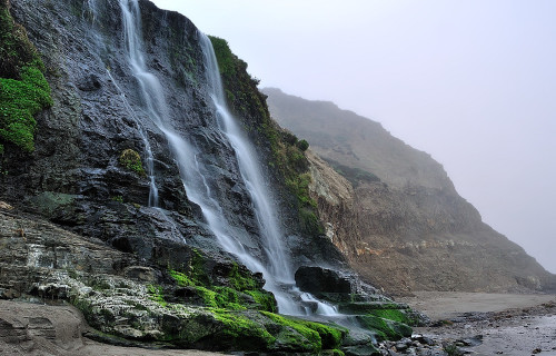
Alamere Falls
CCL: https://bit.ly/3hpOKfc
Alamere Falls Facts
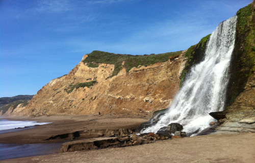
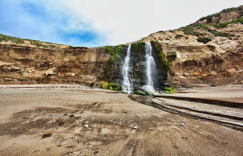
- The fifth and final entry into this article about 5 Geological Marvels of California is the incredibly unusual Alamere Falls.
- The breathtaking work of geological forces known by this name stands out from the crowd. In point of fact, it represents not only a remarkably beautiful waterfall, but also a highly uncommon one. It also forms what’s known as a tidefall.
- The gorgeous site therefore stands out from other cascades, which only adds to its great allure. This truly remarkable and visually stunning fall forms one of only two such in the region. In fact, very few of this type exist anywhere on earth.
- Reaching the site, however, can be quite the arduous undertaking. It can also only be achieved by land via the Coast Trail. This awesome environmental project, created by the California Coastal Conservancy, in 2001, cuts through the region.
- Much of the terrain surrounding the incredible Alamere Falls, however, remains quite rugged in nature. Surprisingly, though, this fact does not deter the determined explorers and adventurers who frequent the beautiful region.
- In point of fact, the very rugged nature of the area serves to make the location a popular one for hikers. Extreme caution must be exercised, however, given the nature of the local geography, as well as conditions in the proximity of the waterfall.
CCL: https://bit.ly/3jW6lgB
Alamere Falls Physical Description
Apart from its great beauty, Alamere Falls also has a very unusual and distinctive formation. It constitutes what’s known as a tiered waterfall, but it’s not content to be a normal one. It actually consists of two relatively widely separated sections.
The first section also often goes overlooked by those not paying sufficient attention to its nature. The lower section receives most of the attention, yet the upper section remains the most complex in nature. But have no fear, for we will explain.
Location upstream from what’s considered the main Alamere Falls further sits the upper falls. This section actually consists of a total of three drops. Uniquely, each of these formed with roughly the same measurements, having a slight plunge equaling roughly 10 ft (3.1 m).
The separated lower section of this stunning formation, though, drops roughly 40 ft (12.2 m) by itself. This additional plunge provides the complete cascade with a total drop of about 70 ft (21.3 m). Though not large in height, it nonetheless creates a striking effect.
CCL: https://bit.ly/3hsLu2T
Alamere Falls Location, Nature, and Distinctiveness
The magnificent feature man calls simply Alamere Falls formed in a part of the world already well known for its many beautiful sites. That’s because the distinctive, and remarkable, waterfall formed in the state of California, in the United States.
More precisely, though, it lies within the confines of what now forms the Point Reyes National Seashore, in Marin County. The formation itself also forms a part of the similarly-named Alamere Creek, which winds tortuously through the surrounding area.
Yet none of these factors, in themselves, explains the full extent of the appeal of the geological marvel to those who encounter it. This, however, actually stems form the incredibly picturesque, not to mention unique, location of the final drop of the waterfall.
The water of the fall itself generally flows throughout the year, and in respectable abundance. At the culmination of that flow remains where the true appeal of it comes into play. The small cliff which it drops over actually hangs over a small beach.
Yet the truly marvelous nature of the amazing Alamere Falls is taken even one step further by the creation of Nature. During periods of high tide, the flow from the falls will drop directly into the ocean, making for a once-in-a-lifetime viewing opportunity.
CCL: http://bit.ly/2N3jmAM
5 Geological Marvels of California
We sincerely hope that you have thoroughly enjoyed this article about 5 Geological marvels of California. Amazingly, these represent only a tiny handful of the wonders of geology with which Nature and time saw fit to bless this particular part of the world.
But these perhaps serve to provide you with a small taste of the beauty to be found here. Unfortunately, some of these 5 Geological Marvels of California now find themselves threatened by the actions of man. It’s up to each of us to protect and preserve them.
Check out our other articles on Earth’s Many Magnificent Marsupials, 4 Exceedingly Rare Trees, Astounding Lizards of the World, 8 Truly Monumental Orchids