It’s our hope that each of you, our readers, will enjoy and appreciate this article we present about these 3 Surprising Sahara Desert Sites. It was certainly our pleasure to gather the information for you. May it provide you with both education and increased awareness.
Certainly, these locations listed herein represent only a portion of the wonders found throughout this amazing region. It’s our belief, though, that they serve as excellent representations of the marvels found here. Check out some of our other articles, as well.
Waw an Namus
Waw an Namus Facts
- Leading off this compendiumof 3 Surprising Sahara Desert Sites we present the remarkable formation known as Waw an Namus.
- The astounding volcano known by the term we’ve used truly distinguishes itself from other, relatively ordinary volcanoes. The name of the magnificent site also has an alternate spelling, however. By either name, though, it’s a breathtaking sight to behold.
- Surprisingly, the English translation of the original name roughly equals Oasis of mosquitoes. The exact age of the formation also remains a point of controversy among scientists. Different pieces of evidence hint at varying ages for this work of Nature.
- The natives of the region knew of the existence of this masterpiece for centuries, prior to its discovery by outsiders. The first mention of it to the rest of the world occurred in 1862. The German explorer Karl Moritz von Beurmann made that report.
- The first known outsider to reach it, however, only did so in 1920. The French explorer Laurent Lapierre had that singular honor. The first known scientist to reach the volcano, did so in 1931. That distinction belongs to the Italian geologist, Ardito Desio.
- In our modern era, this creation of natural forces represents one of the most popular tourist destinations in its region. Those fortunate enough to visit Waw an Namus quickly realize that it has far more to offer the observer than many other volcanoes.
Waw an Namus Physical Description
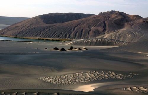
Despite not being its most notable feature, the sheer size of Waw an Namus quickly grabs the attention of visitors. That’s because the caldera itself measures a staggering 2.5 mi (4 km) in diameter. This same feature also boasts a depth measuring roughly 330 ft (100 m).
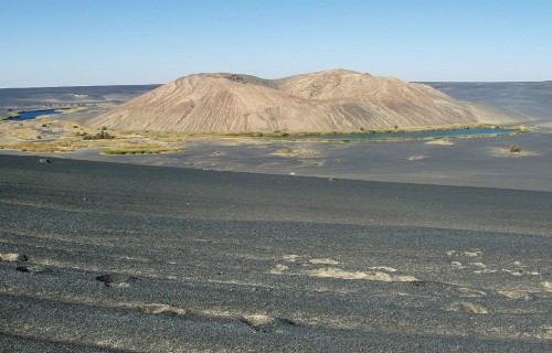
Nestled within the confines of the already remarkable caldera itself, though, lies an equally impressive scoria cone. This natural formation itself measures about 0.81 mi (1.3 km) wide at its base. This section of the volcano also has a height of approximately 460 ft (140 m).
Yet, amazingly, this feature holds yet another crater! This particular one, though, happens to measure roughly 260 ft (80 m) deep, and 490 ft (150 m) wide. The remains of yet another one is situated on the western section of the summit of the crater of Waw an Namus.
Its wonders do not end there, however. A darker colored layer of volcanic fragments extends outward around the central site. This layer, called tephra, extends a mind-boggling distance of 12.4 mi (20 km) in some directions. Its depth ranges from 0.8 – 59 in (2 – 150 cm).
Waw an Namus Location, History, and Ecosystem
The mesmerizing site known as Waw an Namus formed in a part of the world that may shock some individuals. That’s because it lies within the confines of the Sahara Desert! More specifically, it’s found in the Fezzan region of the country of Libya, in Africa.
To this day, the exact age of the structure remains a source of debate among researchers. Studies place its formation at somewhere around 200,000 years ago, give or take about 9,000 years. The scoria cone in the center, though, may be only a few thousand years old.
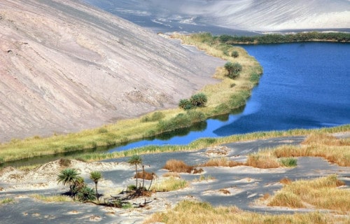
Incredibly, three small lakes actually lie within the caldera of Waw an Namus. Given that evaporation rates in the region exceed precipitation rates, that’s believed to be fed by groundwater. These have a total surface area of around 0.12 sq mi (0.3 sq km).
These lakes remain relatively shallow, however. In fact, the maximum depth of the deepest only reaches 49 – 52 ft (15 – 16 m). Seasonal variations affect the altitude of these bodies of water, as well. Nonetheless, this averages roughly 1,424 ft (434 m) above sea level.
Various other small bodies of water also appear within Waw an Namus. These, however, tend to come and go. All of them sometimes display various shades of red. Unsurprisingly, the colors derive from varying chemical compounds in the surrounding rock strata.
Eye of the Sahara
Eye of the Sahara Facts
- Next up among our choices for inclusion in this article about 3 Surprising Sahara Desert Sites comes the mind-boggling structure known as the Eye of the Sahara.
- This mind-blowing creation of geological processed most often goes by the attention-grabbing name that we’ve applied to it. That’s not the only moniker applied to it, though. That’s because it’s also called the Guelb er Richât and the Richat Structure.
- Regardless of the term one chooses to use, though, it remains an incredible feature. It’s also a source of some controversy among researchers. Although the preponderance of evidence indicates a terrestrial origin, some still think it’s an impact crater.
- Incredibly, this extraordinary geological feature was actually unknown to man until it was accidentally spotted from space. Between its extreme remoteness and its sheer size, no one noticed its uniqueness before, even when passing through it.
- Credit for its discovery as a unique structure goes to two astronauts. During their Gemini 4 mission, they noted the structure by accident. Astronauts White and McDivitt share credit for this highly fortuitous discovery within the annals of science.
- Yet, the aptly-named Eye of the Sahara isn’t only famous for its physical distinctiveness. That’s true due to the many remarkable items found there. The site also contains an extraordinary collection of stone tools dating back as far as 1.7 million years ago.
- Accordingly, the site holds a respected status for this, as well. Due to the existence of such an unparalleled find, it received numerous accolades. The International Union of Geological Sciences chose it as one of the first 100 geological heritage sites.
Eye of the Sahara Physical Description
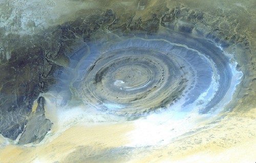
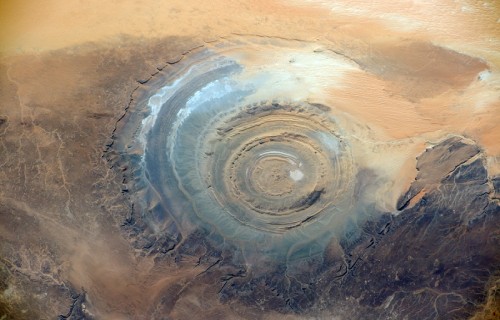
The amazing Eye of the Sahara immediately captivates all those who learn of it. Obviously, its sheer appearance represents an intriguing sight for many individuals. But, the sheer physical dimensions of this natural marvel nevertheless equally astounds the informed.
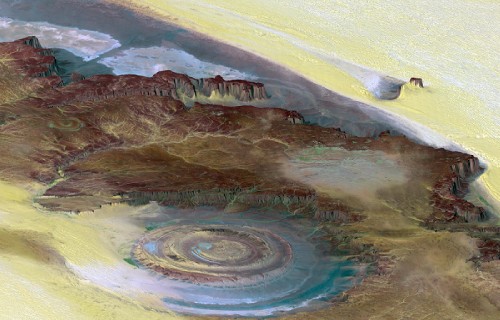
The formation boasts a roughly circular shape, with slightly irregular outlines. Overall, it holds a diameter that measures a stunning 25 mi (40 km). It’s also composed of several concentric rings. The largest of these, the central area, is roughly 19 mi (30 km) in diameter.
Each of its rings manifests a wall, called a dike. The inner ring dike averages 65.6 ft (20 m) thick. It sits about 1.9 mi (3 km) from the approximate center. The outer ring wall, though, is larger, at roughly 164 ft (50 m) thick. But it lies about 4.3-5.0 mi (7-8 km) from the center.
A wide variety of rock structures also appear within the various sections of the Eye of the Shara. These include differing volcanic rocks, gabbros, carbonatites, and kimberlites. Many of these seem to have originated from ancient lava flows within the awesome structure.
Nature didn’t simply stop there, though, when creating this masterpiece. As if these weren’t enough, numerous hydrothermal features also exist inside he confines of the site. These include a multitude of formations consisting of sandstone, silica, and limestone.
Eye of the Sahara Location, Structure, and Mysterious Origins
The location where the mesmerizing Eye of the Sahara formed probably won’t surprise many people. That’s true since it lies in a region of the world already quite well known for its abundance of natural marvels. The site sits on what’s now the continent of Africa.
What’s more, its location’s also extremely remote. This aided in its eluding discovery until modern times. It’s to be found in the western section of the country of Mauritania. This, as the common name clearly indicates, places it in the equally fascinating Sahara Desert.
Situated in the northwestern section of that continent, it’s further located inside another remarkable place. That amazing feature itself remains known, especially locally, as the Adrar Plateau. In the country it appears in, this puts it in the western central portion.
The Eye of the Sahara represents what scientists call an elliptical dome, albeit a highly eroded one. Several distinct layers of sedimentary rocks appear inside its walls. A wide variety of minerals are present, as well. These include limestone and quartz-rich sandstone.
It’s widely believed by the majority of geologists to be the result of uplift. Evidence indicates that its creation began approximately 100 million years ago. Studies undertaken in the 1950’s and 1960’s, in the minds of most researchers, disproved the impact theory.
Erg Chebbi
Erg Chebbi Facts
- Closing out this composition about these 3 Surprising Sahara Desert Sites we give you the impressive location known as Erg Chebbi.
- The simple term it’s known by serves as the english language translation of the name for this remarkable work of natural processes. Within the region in which it formed, however, it’s best known by another moniker in the Arabic language.
- This marvel of Nature also sits in a relatively remote area. That’s because the nearest sizable human habitation lies roughly 37 mi (60 km) from the boundary of this site. A small tourist center has also been established near the periphery of the region.
- The structure further distinguishes itself due to the scaricty of such features in the surrounding region. In fact, this geological formation represents one of only two such formations, known by the term of erg, found in the country in which it sits.
- Given its natural appeal and stark beauty, it’s not surprising that it now serves as a center of tourism. Its remoteness, though, serves to limit this, at least to a reasonable degree. It nevertheless does serve as a respectable source of income in the region.
- The predominant method of accessing Erg Chebbi continues to be camel train. Many local residents also access the site, however. Being buried neck-deep in the sands for a few minutes at at time is considered in local belief to be a treatment for rheumatism.
Erg Chebbi Physical Description
The amazing feature known as Erg Chebbi amazes those who encounter it for a variety of reasons pertaining to its physical characteristics. It’s impossible to say which of these ranks as most impressive, though, because individuals perspectives naturally vary.
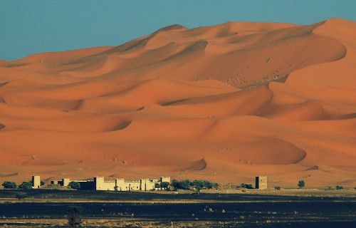
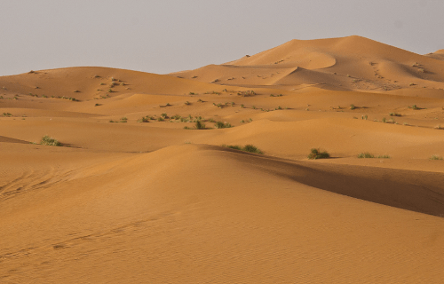
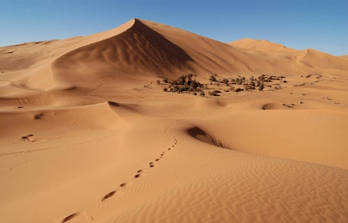
This product of natural forces represents a comparatively large example of what’s called a dune sea. It directly owes its formation to the action of widblown sands, accumulated over a vast span of time. Beneath them, however, lies a rocky base, known as a hamada.
Perhaps the most remarkable trait of this site, for the majority of individuals, is its sheer height. That’s due to the fact that these attain heights measuring as much as 492 ft (150 m) in some locations. These rise from the surrounding terrain, creating a visual masterpiece.
Yet the earth wasn’t content to simply stop its efforts here at pure size alone. Combined with the actions of local forces, random chance also created a highly unique shape here. More precisely, this wonder of the desert possesses a roughly rectangular shape.
Erg Chebbi also displays other respectable dimensions. Running from north to south, this imposing structure measures about 31 mi (49.9 km). Extending east to west, however, it extends about 6.2 mi (10 km). Both of these vary, of course, due to local conditions.
Erg Chebbi Location and Ecology
The visual marvel known by the name of Erg Chebbi formed in a remote region of the globe. This area is already renowned for its abundance of natural wonders. That’s due to the fact that it’s situated on what now bears the moniker of the continent of Africa.
More exactly, it lies in the extreme northwestern portion of the continent. Its location further places it within the confines of the country of Morocco. The varying boundaries of the structure also coincidentally cause it to roughly line the border with Algeria.
As a general principle, the local climate of the surrounding area developed as quite harsh and arid. As remains typical of such regions, vegetation amid the stark beauty of the site also generally qualifies as almost non-existent within its boundaries.
Largely due to this situation fauna also remains extremely scarce within its boundaries. The few known species that do survive inside this dune field in sporadic concentrations include pink asphodels, mauve statice, Fennec Fox, desert hedgehog, and jerboa.
Researchers discovered an entirely new, and physically distinctive, species of wolf spider living within the confines of the erg. A preliminary scientific study of this new species remains underway. Therefore, no detailed information about it is available at this time.
The predominant weather patterns of Erg Chebbi classify as seasonal and generally quite unpredictable. Sandstorms also occur frequently and often arise with little warning. Rainfall within the boundaries of this remarkable site also occurs highly infrequently.
3 Surprising Sahara Desert Sites
We hope that each of you thoroughly enjoyed reading, and hopefully learning from, this article we’ve written about these 3 Surprising Sahara Desert Sites. It’s also our hope that doing so has left you with either a new or renewed appreciation for such wonders of Nature.
Unfortunately, many other such features around the world now find themselves facing threats to their continued existence in an undamaged state. Many of those dangers, in fact, stem from the actions of mankind. We must do all we can to protect and preserve them all.
Check out our other articles on 7 Magical North American Moths, The Mighty Tornado, 5 Fully Fabulous Foxes, 4 Remarkably Evolved Reptiles, Fabulous Fungi Around the Globe


Leave a Reply