


CCL: https://bit.ly/3Ad8z0O
It’s our great hope that each of you, our readers, will enjoy and appreciate this article we present to you about Africa’s Many Geological Masterpieces. It was certainly our true pleasure to gather the information for you. May it serve to provide you with both education and increased awareness.
Certainly, these formations listed herein represent only a portion of the wonders found throughout this amazing region of the world. It’s our belief, though, that they serve as excellent representations of the marvels found here. Check out some of our other numerous other articles, as well.
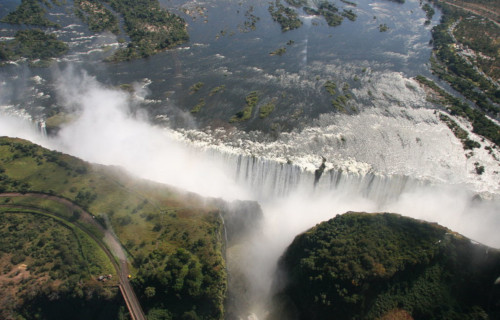
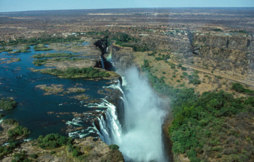
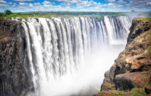
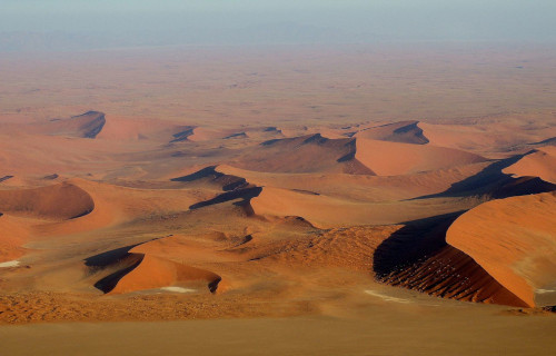
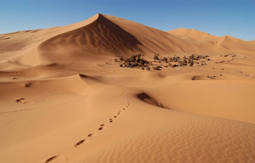
Victoria Falls
CCL: https://bit.ly/3oUY0Jv
Victoria Falls Facts
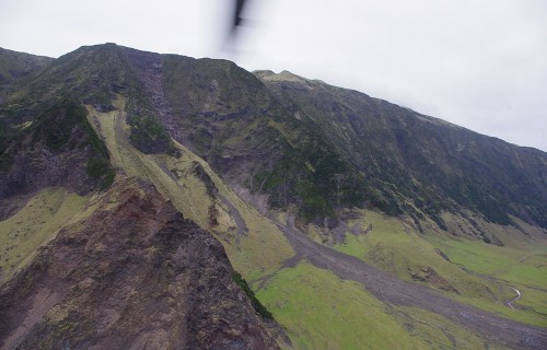
- Leadinng off this article about Africa’s Many Geological Mastepieces we present the astounding beauty of the site known as Victoria Falls.
- The natural marvel known by this name remains one of the most spectacular sites on earth. That’s the name applied to it by European explorers, however. The local Indigenous Peoples named it Mosi-oa-Tunya, meaning The Smoke that Thunders.
- The renowned Scottish explorer and missionary, Stanley Livingstone, became the first known European to encounter it. That history setting event occurred on November 16, 1885. Evidence indicates, however, that locals knew of it as far back as the Stone Age.
- The combination of its extreme width and height earn it a place in the record books. These statistics qualify it as one of the largest waterfalls in the entire world. As a result, UNESCO currently lists this wonder of Nature as a World Heritage Site.
- Somewhat ironically, though not surprisingly, another waterfall bears the exact same name. This one, located in Scotland, in Europe, however, though lovely, holds no comparison in terms of size. Both bear their names in honor of Queen Victoria.
- The better known Victoria Falls now finds itself facing severe threats. Environmental conditions related to climate change threaten its natural existence. Steadily increasing temperatures have begun to dramatically and steadily reduce the water flow.
CCL: https://bit.ly/3quUrtZ
Victoria Falls Physical Description
Despite its great and fully deserved fame, the wondrous Victoria Falls isn’t either the widest or tallest known waterfall. Its combined physical statistics nevertheless make for a truly impressive example of the work of Nature. It’s also a breathtakingly beautiful site to behold.
The precise width of the body of water actually varies, due to the inflow of water. That variation, however, until recent years, always remained proportionately minor. On average, though, this stunning waterfall boasts a width of roughly 5,604 ft (1,708 m).
Its measured height of approximately 354 ft (108 m) also makes it nearly twice as tall as Niagara Falls, in North America. The combination of its height and width provides it with what’s generally regarded as the single largest sheet of falling water on earth.
Two small islands also appear in the flow, situated quite close to the edge of Victoria Falls. These do, however, remain large enough to divide the flow of water, even during extreme flow. These features bear the names of Boaruka Island, and Livingstone Island.
Victoria Falls Location, Formation, and Ecosystem
In a twist of irony, the staggering Victoria Falls formed in a region of the world usually associated with aridity. That’s because this wonder formed in a portion of the continent of Africa. More precisely, though, it lies in what now forms the country of Zimbabwe.
This feature, itself worthy of note, further represents part of the Zambezi River. In the distant past, however, the rive followed an entirely different route. An gradual but steady upward movement of the land about 2 million years ago, altered that to its current course.
Evidence also indicates that its course could be in the process of changing again. That’s due to the fact that a portion of one edge of the western bank seems to be eroding. This section currently carries the greatest concentration of the flow rate during flooding.
Two small but vital National Parks presently lie along its banks. These bear the names of Victoria Falls National Park, and Mosi-oa-Tunya National Park. Though locally important, both nevertheless have a combined total area of only around 33.9 sq mi (89 sq km).
These contain large numbers of wildlife, both in species and individuals. This include sizeable populations of Cape Buffalo, giraffe, elephants, lions, and several types of antelopes. Smaller but relatively significant numbers of leopards and cheetahs also appear here.
Vervet monkeys also live within the parks in large numbers, along with various baboons. Crocodiles and hippos additionally thrive in the waters approaching the beautiful Victoria Falls. Dozens of species of birds, including raptors further inhabit the parks.
The surrounding environment, meanwhile, mostly consists of mopane woodland savannah. Less sizeable, but nonetheless important, areas of woodlands and scrubland also dots the surrounding region. A thriving rainforest also appears, due to the moisture.
Waw an Namus
CCL: https://bit.ly/3outSoq
Waw an Namus Facts
- Now appearing in this compilation of Africa’s Many Geological Materpieces comes the intriguing creation named Waw an Namus.
- The astounding volcano with the unique name truly distinguishes itself from other, relatively ordinary volcanoes. The name of the magnificent site also has an alternate spelling, however. By either name, though, it’s a breathtaking sight to behold.
- Surprisingly, the English translation of the original name roughly equals Oasis of mosquitoes. The exact age of the formation also remains a point of controversy among scientists. Different pieces of evidence hint at varying ages for this work of Nature.
- The natives of the region knew of the existence of this masterpiece for centuries, prior to its discovery by outsiders. The first mention of it to the rest of the world occurred in 1862. The German explorer Karl Moritz von Beurmann made that report.
- The first known outsider to reach it, however, only did so in 1920. The French explorer Laurent Lapierre had that singular honor. The first known scientist to reach the volcano, did so in 1931. That distinction belongs to the Italian geologist, Ardito Desio.
- In our modern era, this creation of natural forces represents one of the most popular tourist destinations in its region. Those fortunate enough to visit Waw an Namus quickly realize that it has far more to offer the observer than many other volcanoes.
Public Domain Image
Waw an Namus Physical Description
Despite not being its most notable feature, the sheer size of Waw an Namus quickly grabs the attention of visitors. That’s because the caldera itself measures a staggering 2.5 mi (4 km) in diameter. This same feature also boasts a depth measuring roughly 330 ft (100 m).
Nestled within the confines of the already remarkable caldera itself, though, lies an equally impressive scoria cone. This natural formation itself measures about 0.81 mi (1.3 km) wide at its base. This section of the volcano also has a height of approximately 460 ft (140 m).
Yet, amazingly, this feature holds yet another crater! This particular one, though, happens to measure roughly 260 ft (80 m) deep, and 490 ft (150 m) wide. The remains of yet another one is situated on the western section of the summit of the crater of Waw an Namus.
Its wonders do not end there, however. A darker colored layer of volcanic fragments extends outward around the central site. This layer, called tephra, extends a mind-boggling distance of 12.4 mi (20 km) in some directions. Its depth ranges from 0.8 – 59 in (2 – 150 cm).
CCL: https://bit.ly/2MM3wQH
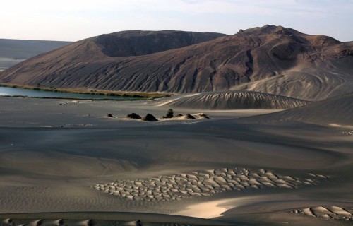
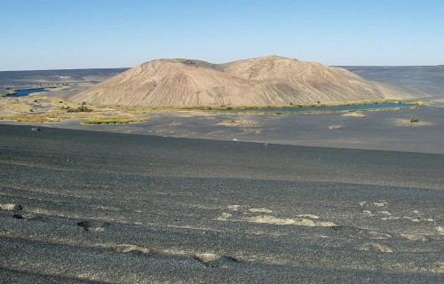
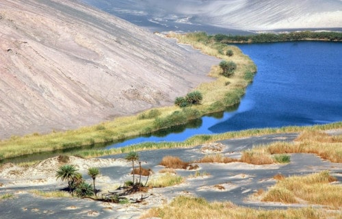
Waw an Namus Location, History, and Ecosystem
The mesmerizing site known as Waw an Namus formed in a part of the world that may shock some individuals. That’s because it lies within the confines of the Sahara Desert! More specifically, it’s found in the Fezzan region of the country of Libya, in Africa.
To this day, the exact age of the structure remains a source of debate among researchers. Studies place its formation at somewhere around 200,000 years ago, give or take about 9,000 years. The scoria cone in the center, though, may be only a few thousand years old.
Incredibly, three small lakes actually lie within the caldera of Waw an Namus. Given that evaporation rates in the region exceed precipitation rates, that’s believed to be fed by groundwater. These have a total surface area of around 0.12 sq mi (0.3 sq km).
These lakes remain relatively shallow, however. In fact, the maximum depth of the deepest only reaches 49 – 52 ft (15 – 16 m). Seasonal variations affect the altitude of these bodies of water, as well. Nonetheless, this averages roughly 1,424 ft (434 m) above sea level.
Various other small bodies of water also appear within Waw an Namus. These, however, tend to come and go. All of them sometimes display various shades of red. Unsurprisingly, the colors derive from varying chemical compounds in the surrounding rock strata.
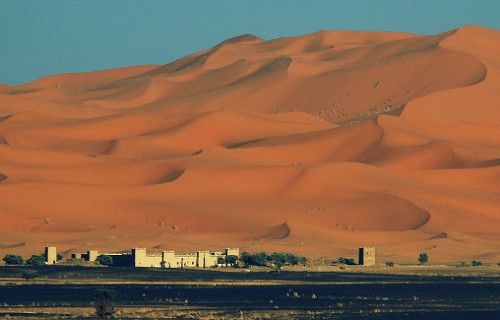
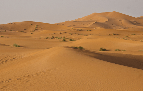
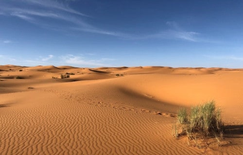
Namib Desert
CCL: https://bit.ly/3eNhB9V
Namib Desert Facts
- The third entry into this compendium of Africa’s Many Geological Masterpieces is the fabulous location known as the Namib Desert.
- Most notably, this astounding location remains one of the most remarkable and impressive such features in the world. The incredible feature of geology also represents the only true desert to be found in its part of the continent on which it appears.
- This truly spell-binding location actually holds several distinctions that quite clearly set it apart from other deserts. This marvel of Nature additionally appears to be extremely old. In fact, it potentially constitutes the oldest surviving desert in the world.
- The surprising uncertainty exists due to varying opinions among scientists as to its exact age. This astonishing feature also possesses a somewhat unusual shape. Its dimensions remain highly elongated, with its length being roughly ten times its width.
- The amazing Namib Desert also stands out from similar features for the extreme aridity it developed. It earns this recognition even in comparison with the other desert regions around the globe. To be precise, this magnificent site ranks as dry even for a desert.
- Portions of its area rank among the most arid regions of earth, with only the Atacama Desert, in South America, to rival them. Amazingly, this marvel also serves as home to several species found nowhere else on earth, including the awesome Medusas Head.
- Its many extremes further served to earn it an honorable distinction that few similar features can claim. That holds true since that UNESCO named it a World Heritage Site. Of the 23 recognized deserts in the world, only a handful can make that specific claim.
Namib Desert Physical Description
Although the stunning Namib Desert grabs one’s notice for many reasons, physical size isn’t among them. That statement holds true due to the fact that, despite its legitimately impressive numbers, the site only ranks as 23rd among the largest deserts on earth.
This particular desert, although not expansive relative to some, still garners much-deserved notice. To begin with, it must be noted that, like other similar features, the dimensions vary slightly. This, quite understandably, occurs due to various natural processes.
It has an overall length measuring roughly 1,200 mi (1,931 km). Despite this, its overall width generally only averages about 120 mi (193 km). These dimensions, while slightly variable, serve to give the site an extremely elongated, roughly rectangular shape.
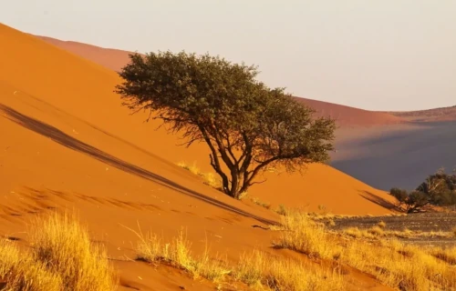
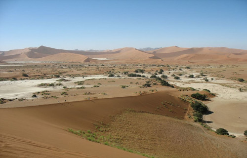
In addition to the ubiquitous sand inherent to its nature, the starkly stunning Namib Desert also boasts other remarkable features. Among these, however, its remarkable and visually impressive sand dunes remain of paramount interest to most viewers.
That’s partly because of their extreme size. Amazingly, these natural formations measure an astounding 980 ft (300 m) high. But, these also extend for a difficult to imagine length of about 20 mi (32 km). Due to that, these rank as the second largest in the world.
Namib Desert Location, Geology, and Climate
The Namib Desert also formed in a region of the world known for its natural wonders. It sits on the continent of Africa. The confines of this arid wonderland lie within the boundaries of the countries of South Africa, Angola, and Namibia, from which its name derives.
The site also holds another surprise. This desert actually runs along the edge of the continent, abutting the Atlantic Ocean. It also runs from the Angola-Namibia border in the north, to as far south as the Olifant River, located in Western Cape, South Africa.
The region includes a vast dune sea. These dunes exhibit varying colors. These include hues ranging from bright orange to pink. The variations in color result from differences in the mineral composition of the sand. This part of the desert comes from different sources.
The climate of the Namib Desert remains unique. It consists of several extremes. The aridity stems from dry air descending from a global atmospheric circulation. Meanwhile, humid winds from the ocean create frequent dense fogs along the edge of the desert.
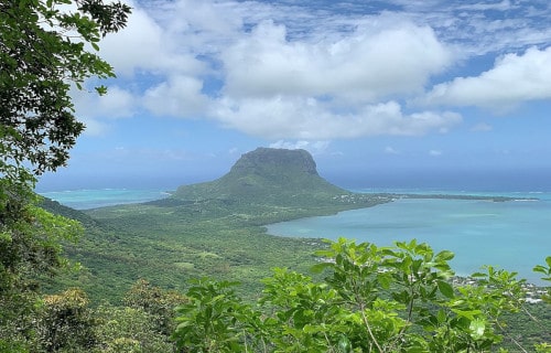
Le Morne Brabant
CCL: https://bit.ly/3qDoPnb
Le Morne Brabant Facts
- Making its appearance now in this listing of Africa’s Many Geological masterpieces we give you the marvel that is Le Morne Brabant.
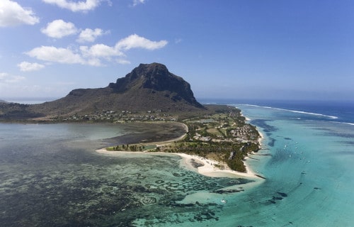
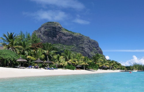
- As can be clearly seen, the term applied to it serves as the name for a geological marvel. It also ranks as an incredibly beautiful and unique geological formation. In point of fact, this fabulous site represents a highly distinctive peninsula.
- This magnificent site itself also formed as connected to an equally beautiful location. It actually connects to the equally stunning island of Mauritius. Intriguingly, the awesome work of Nature was additonally named in honor of its very discovery.
- It just so happened that a ship forming part of the Dutch East India Company ran aground on the cliffs of the stunning site. The ship, quite unsurprisingly, bore the name of the Brabant. This fortuitous accident occurred in the year 1783.
- This visually captivatinig site also possesses a history rich in varied culture. In some cases, this historical richness also extends to include legends. Originally, in the early 19th century, the breathtaking location served as a haven for runaway slaves.
- After the abolition of slavery in Mauritius, a true tragedy subsequently took place here. Many escaped slaves supposedly jumped to their deaths when police came to inform them of their liberation, believing they had come to retake them.
- But, the peninsula of Le Morne Brabant boasts many claims to fame. Among others is the fact that its natural beauty and historical significance earned it a very great honor. In point of fact, UNESCO named it a World Heritage Site in the year 2008.
CCL: https://bit.ly/2RHjNWB
Le Morne Brabant Physical Description
Although physically attached to the island of Mauritius, the dazzling Le Morne Brabant nevertheless has its own physical dimensions. Those are impressive in themselves. By definition, the astonishingly lovely natural site developed with a roughly rectangular shape.
The total area of the beautiful peninsula further measures roughly 864 acres (349.6 ha). That’s a quite respectable area in its own right. This unique spot on the surface of the earth currently remains best known for two separate natural wonders, however.
The first of these continues to be the presence of an enormous monolith, primarily formed of basalt. Its summit sits at an altitude of 1,824 ft (556 m) above sea level. The summit of this towering monolith covers a total of an extraordinary 30 acres (12 ha).
The second of the startling natural marvels for which Le Morne Brabant remains famous truly stuns the first-time observer. This marvel of illusion also lies situated just off the southwestern shore. For most people visiting, this sight must be seen to be believed.
That’s because, in that precise location, Nature itself creates a mind-boggling illusion. It’s formed by a sediment comprised of silt and sand. These come together in a manner that, to the observer, gives the appearance of an actual underwater waterfall.
Le Morne Brabant Location, Geology, and Ecology
Given its attachment to Mauritius, the location named Le Morne Brabant developed at the extreme southwestern point of the island. More precisely, however, this positioning places this particular wonder of Nature 1,200 mi (2,000 km) from the continent of Africa.
The underwater waterfall and the towering monolith should be enough to amaze one. But, the workings of natural forces also blessed the site with many other natural marvels. These stunning sights for the eye also come in many forms. That’s also amazing in itself.
For one, the shoreline of the peninsula has numerous beaches, blessed with dazzling white sand and crystal clear waters. In addition to that, the peninsula also a multitude of caves. Many of these formations provided shelter to escaped slaves in the past.
The extremely steep slopes of the breathtaking monolith also boast yet another astonishing feature. That’s formed by a dotting of sheer overhangs for the adventurous. The site itself remains almost completely surrounded by a combination of a lagoons and reefs.
One must never forget the beautiful flora and fauna of Le Morne Brabant, though. Much of the site presently holds a steady covering of beautiful and impressive plant life. This includes such wonders as indigenous trees and countless smaller types of fauna.
Not stopping there, it also boasts one last claim to fame. In this case, it’s one of rarity. This holds true given the fact that the location provides a refuge for two extremely rare plants. Both evolved as small shrubs, and appear nowhere else except this island.
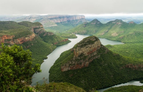
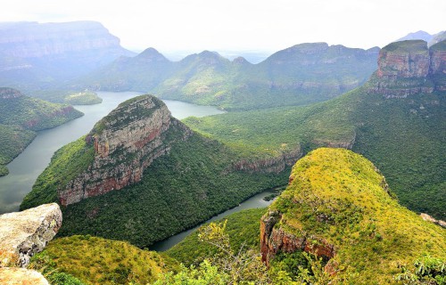
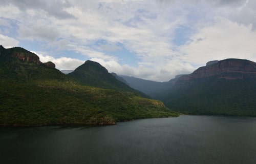
Blyde River Canyon
CCL: https://bit.ly/2RkdLeQ
Blyde River Canyon Facts
- The fifth feature showing in this article about Africa’s Many Geological Masterpieces holds the informative name of Blyde River Canyon.
- To the surprise of some, the truly stunning wonder of Nataure stands out from other such features throughout the world for several reasons. These reasons, however, involve a wide variety of factors. Admittedly, though, some of them concern perspectives.
- Perhaps chief among these reasons remains the fact that the site ranks as one of the largest known canyons in the world. This remarkable location additionally represents one of the largest examples of a specific type of canyon, known as a green canyon.
- The inhabitants of the continent it formed on further consider it to be one of the great natural wonders of that region of the globe. Its somewhat distinctive name only further serves to distinguish this geological marvel from other similar features.
- This particular moniker derives from those explorers who first encountered it. That’s due to a Dutch expedition that took place during the early portion of the 18th century. In that language, the word Blyde translates as either happy or glad.
- Impressively, this site also serves as the cornerstone of the Blyde River Canyon Nature Reserve. The canyon further serves as home to a wide variety of flora and fauna. Quite understandably, the location now constitutes and extremely popular tourist site.
Blyde River Canyon Physical Description
Likely the most notable thing about the truly magnificent Blyde River Canyon remains its sheer physical size. That holds true due to a truly impressive measurement. More precisely, this masterpiece of Nature stretches for an overall length of roughly 3.1 mi (50 km).
The feature also boasts a maximum measured depth of about 2,625 ft (800 m). Its overall physical measurements, however, do not represent its only claim to magnificence. That’s because, among other things, it also possesses some truly incredible cliffs.
In point of fact, these form some of the highest and most precipitous such features found in any canyon on the entire planet. The visually breathtaking Blyde River Canyon actually represents one wonder of Nature that contains many other natural surprises, as well.
That’s true since the gorgeous canyon also plays host to numerous natural marvels bearing their own share of distinctive names. These also represent many distinct types of natural features. Such wonders include such wonders as the Kadishi Tufa Waterfalls.
These additionally rank as the second highest of their kind in the world. Thesy include features bearing such intriguing names as The Pinnacle, God’s Window, Bourke’s Luck Potholes, the Three Rondavels, and the Echo Caves. Each forms a different type of feature.
Blyde River Canyon Location, Formation, and Life
The awesome wonder of Nature currently known as the Blyde River Canyon formed in what now constitutes the country of South Africa, on the continent of Africa. More specifically, the site lies within the boundaries of the province of Mpumalanga.
This location, itself appealing, sits in the eastern portion of the country. There, the fabulous canyon originally formed as part of the ancient super continent known as Gondwanaland. This gigantic formation eventually broke apart around 200 million years ago.
Subsequent to this, what had previously been a very deep undersea trench actually, over time, of course, became the canyon we see today. Today, though, the beautiful and incredible location possesses a remarkably lush environment within its boundaries.
As a result, it serves as home to numerous species of mammals, birds, and fish. Some of these species are rarely ever seen, thus it serves as a haven for these, and other species. Their presence only serves to enhance the majesty of the location to even greater degrees.
The mammals found within its boundaries include the Vervet Monkey. But the great majority of creatures found here consists of birds, including the amazing Crowned Eagle. Amazingly, reptilian species such as the crocodile also appear here in relatively large numbers.
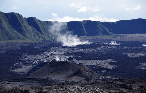
Piton de la Fournaise
CCL: https://bit.ly/1xMszCg
Piton de la Fournaise Facts
- The next wonderful location in this compendium of Africa’s Many Geological Masterpieces is the spellbinding Piton de la Fournaise.
- This magnificent creation of geological forces is best known throughout the world by the French language name that we’ve used here. Local residents sometimes also refer to this natural marvel simply by the short but descriptive term of le Volcan.
- Regardless of the moniker one applies to it, though, it stands out from others of its type due to its present nature. That holds true due to the fact that it’s highly active. In fact, it currently ranks as one of the most active volcanoes on the planet.
- This ranking actually places it with the likes of Mount Erebus, Stromboli, Mt. Etna, and Kilauea. Thus, while magnificent, it nevertheless remains an extremely hazardous location. Despite this, though, it’s become an extremely popular tourist destination.
- Local officials take every precaution possible with the safety of local population and tourists alike. To than end, the volcano continues to be closely monitored at all times by numerous instruments. This provides for some warning of impending eruptions.
- The most recent eruption of Piton de la Fournaise occurred on December 7, 2020. The aforementioned monitoring of the site, however, provided warning to local officials. That prompted the closing of the site to visitors prior to that eruption.
- In an ironic twist, this marvelous yet dangerous site sits within a National Park. Itself a World Heritage Site, it bears the name of the Réunion National Park .This serves as the principal reason for the diligence of the authorities in observing its activities.
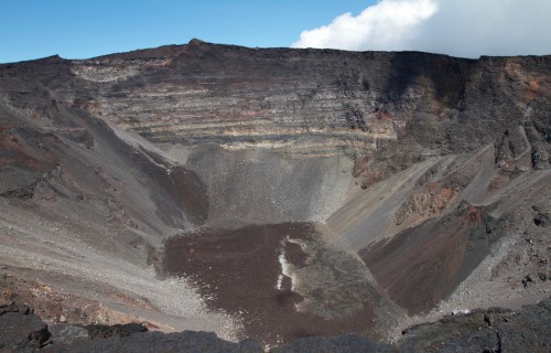
Piton de la Fournaise Physical Description
It bears noting that the breathtaking Piton de la Fournaise, cannot be compared with your typical volcano. That’s because its gigantic caldera boasts some truly impressive dimensions. More precisely, it has an astonishing diameter measuring roughly 5 mi (8 km).
In case this does not impress the reader, however, Nature did not simply stop there. That’s true since it also boasts other incredible dimensions. That’s because it stands an imposing 8,635 ft (2,632 m) tall. That alone elevates it to extreme status, no pun intended.
Yet the marvels of this geological wonder do not end there. Within its already incredible confines lies a lava shield that posseses a diameter of approximately 1,300 ft (396m). Few volcanoes on the planet have features rivaling those of this spectacular site.
Astonishingly, the list of features to be found in Piton de la Fournaise just keeps rolling. Indeed, numerous other geological formations line the inside of the enormous crater. These primarily consist of much smaller craters and volcanic features known as spatter cones.
Over time, and simply adding to its impressiveness, another visually stunning feature came into existence. That’s due to the fact that, on the southeast side of the caldera, the sea breached its walls. This only augments the incredible array of sights to behold here.
CCL: https://bit.ly/1xMszCg
Piton de la Fournaise Location and Activity
The air of magic pervading the marvelous yet dangerous Piton de la Fournaise also owes part of its presence to its location. That’s because the intriguing volcano additionally formed in an extremely remote part of the world. That region’s already known for its marvels.
More precisely, though, it sits on the eastern side of what now holds the name of Reunion Island. That site itself formed in the Indian Ocean, near the continent of Africa. This places the tantalizing creation of ongoing natural processes east of the island of Madagascar.
According to scientific research, this stunning volcano formed roughly 530,000 years ago. In relative geological terms, it is thus comparatively young. It further represents only a portion of what experts call the Reunion hotspot, active for nearly 66 million years.
Though extremely active, the phenomenal Piton de la Fournaise typically produces comparatively slow-moving flows, as opposed to violent eruptions. The majority of its activity therefore falls into the category of basaltic flows. Over 150 have been recorded.
While most of these remain inside the caldera, a few do leave its boundaries, however. The most recent of these occurred in February of 2019. But, in all of this, only 6 have reached beyond the caldera. That could change at some point though, due to its active nature.
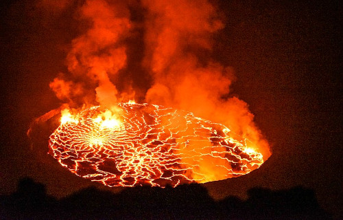
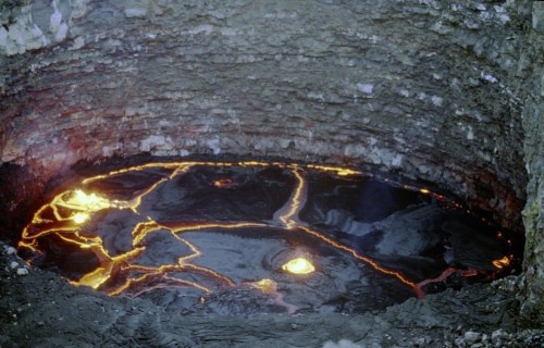
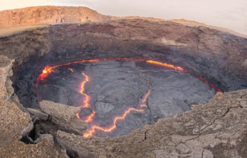
Nyiragongo Volcano
Nyiragongo Volcano Facts
- Our seventh choice for inclusion in this collection of Africa’s Many Geological Masterpieces bears the moniker of the Nyiragongo Volcano.
- Regrettably, this creation of geological processes bears this somewhat hard to pronounce name. It’s perhaps best known, at least to researchers, for its unique combination of factors. Vulcanologists continue to study the formation even today.
- In fact, those ongoing investigations keep geologists, vulcanologists, and those specializing in related fields busy. That’s mainly due to the extreme variability of conditions in and around its confines. While fascinating, this also remains dangerous.
- The site also stands out from similar formations around the world. It further does so for a variety of reasons. Perhaps chief among these is its sheer volume. While this varies, the average amount of lava contained within it staggers the imagination.
- More precisely, the average amount of lava it contains makes it the largest regularly maintained lava lake in the world. The lava produced by this volcano additionally garners much interest, and thus study, due to its intriguing and unusual nature.
- That’s true since the lava produced by the Nyiragongo Volcano has an extremely fluid consistency. This occurs due to its containing an unusually high concentration of alkali-rich volcanic rock. That nature creates a remarkable effect on its eruptions.
- Coincidentally, this impressive volcano also possesses a relatively steep slope. Its flows often literally do flow, almost like water. Combined with the fluid consistency of that lava and its proximity to populated areas, it’s viewed as a highly dangerous volcano.
CCL: https://bit.ly/3jv8FL5
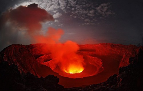
Nyiragongo Volcano Physical Description
The fabulous Nyiragongo Volcano represents an excellent example of the specific variety that experts classify as a stratovolcano. That’s one displaying a roughly conical shape, that’s also formed of multiple layers of hardened lava and debris, known as tephra.
This wonder of vulcanism also remains highly active, and indeed, is almost constantly so. This makes it one of the few of its type in the world for which this holds true. Its precise shape and dimensions are therefore constantly changing, at least to small degrees.
This turbulent marvel of its region additionally boasts other impressive physical statistics. It stands quite tall, with a height equaling roughly 11,380 ft (3,470 m). The primary crater itself also stands out for its sheer size, measuring almost 1.25 mi (2 km) in width.
The ever-present lava lake of the Nyiragongo Volcano adds yet another distinctive characteristic to the site. That’s because it has an average depth of nearly 2,000 ft ( 600 m). Yet the nature of the lava itself remains the most distinctive feature of this prodigious peak.
This has an extremely high alkali ratio, which allows for its flowing rapidly down its steep slopes. As a result, flow speeds sometimes reach 60 mph (96 kph). Due to its combination of slope and lava fluidity, its flow speeds represent the fastest currently known to man.
Nyiragongo Volcano Location and History
The extraordinary Nyiragongo Volcano formed in a region of the world already renowned for its wide variety of other natural wonders, many equaly amazing. That’s true since the earth’s forces created the site on what now constitutes the continent of Africa.
There, however, it sits in what’s now the Virunga National Park. This protected region itself sits within the boundaries of the Democratic Republic of the Congo. Astonishingly, its geographical location presently places it less than 12 mi (20 km) from a populated area.
For the moment, vulcanologists still know little of its ancient eruptive history. During its activity in modern times, though, events remains well documented. The volcano has erupted at least 34 times since 1882. Incredibly, some of these eruptions lasted for years at a time.
This amazing volcano also has an amazing history all its own. It actually overlaps with several older volcanoes and sits amid hundreds of small cinder cones. Because of its unique dangers, the Nyiragongo Volcano was named as a Decade Volcano in 1991.
In March of 2016, the Goma Volcano Observatory discovered that a new vent had opened on the northeast edge of the crater. Since that time, various rumblings and small quakes have continued to occur within its confines. It’s by no means finished amazing us.
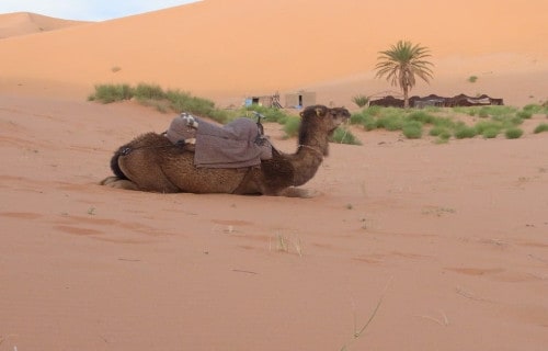
Erg Chebbi
CCL: https://bit.ly/1jxQJMa
Erg Chebbi Facts
- Here, among these selections of Africa’s Many Geological Masterpieces, we present the fabulous creation of Nature known as Erg Chebbi.
- The simple term for the wonder serves as the english language translation of the name for this remarkable work of natural processes. Within the region in which it formed, however, it’s best known by another moniker in the Arabic language.
- This marvel of Nature also sits in a relatively remote area. That’s because the nearest sizable human habitation lies roughly 37 mi (60 km) from the boundary of this site. A small tourist center has also been established near the periphery of the region.
- The structure further distinguishes itself due to the scaricty of such features in the surrounding region. In fact, this geological formation represents one of only two such formations, known by the term of erg, found in the country in which it sits.
- Given its natural appeal and stark beauty, it’s not surprising that it now serves as a center of tourism. Its remoteness, though, serves to limit this, at least to a reasonable degree. It nevertheless does serve as a respectable source of income in the region.
- The predominant method of accessing Erg Chebbi continues to be camel train. Many local residents also access the site, however. Being buried neck-deep in the sands for a few minutes at at time is considered in local belief to be a treatment for rheumatism.
CCL: https://bit.ly/1jxQJMa
Erg Chebbi Physical Description
The amazing feature known as Erg Chebbi amazes those who encounter it for a variety of reasons pertaining to its physical characteristics. It’s impossible to say which of these ranks as most impressive, though, because individuals perspectives naturally vary.
This product of natural forces represents a comparatively large example of what’s called a dune sea. It directly owes its formation to the action of widblown sands, accumulated over a vast span of time. Beneath them, however, lies a rocky base, known as a hamada.
Perhaps the most remarkable trait of this site, for the majority of individuals, is its sheer height. That’s due to the fact that these attain heights measuring as much as 492 ft (150 m) in some locations. These rise from the surrounding terrain, creating a visual masterpiece.
Yet the earth wasn’t content to simply stop its efforts here at pure size alone. Combined with the actions of local forces, random chance also created a highly unique shape here. More precisely, this wonder of the desert possesses a roughly rectangular shape.
Erg Chebbi also displays other respectable dimensions. Running from north to south, this imposing structure measures about 31 mi (49.9 km). Extending east to west, however, it extends about 6.2 mi (10 km). Both of these vary, of course, due to local conditions.
CCL: https://bit.ly/1jxQJMa
Erg Chebbi Location and Ecology
The visual marvel known by the name of Erg Chebbi formed in a remote region of the globe. This area is already renowned for its abundance of natural wonders. That’s due to the fact that it’s situated on what now bears the moniker of the continent of Africa.
More exactly, it lies in the extreme northwestern portion of the continent. Its location further places it within the confines of the country of Morocco. The varying boundaries of the structure also coincidentally cause it to roughly line the border with Algeria.
As a general principle, the local climate of the surrounding area developed as quite harsh and arid. As remains typical of such regions, vegetation amid the stark beauty of the site also generally qualifies as almost non-existent within its boundaries.
Largely due to this situation fauna also remains extremely scarce within its boundaries. The few known species that do survive inside this dune field in sporadic concentrations include pink asphodels, mauve statice, Fennec Fox, desert hedgehog, and jerboa.
Researchers discovered an entirely new, and physically distinctive, species of wolf spider living within the confines of the erg. A preliminary scientific study of this new species remains underway. Therefore, no detailed information about it is available at this time.
The predominant weather patterns of Erg Chebbi classify as seasonal and generally quite unpredictable. Sandstorms also occur frequently and often arise with little warning. Rainfall within the boundaries of this remarkable site also occurs highly infrequently.
Sahara
Sahara Facts
- The ninth entry into this article about Africa’s Many Geological Masterpieces is the world-renowned feature known as the Sahara.
- The term given refers to a truly phenomenal region. That’s because it qualifies as the largest and best known hot desert on earth. Only the Arctic and Antarctic measure larger in overall area. These, however, classify as cold deserts, thus do not compare.
- It partly owes its remarkableness to where it formed. That’s due to the fact that the majority of the desert lies in the northern part of Africa. The total area of the desert also compares to the combined surface area of both the United States and China.
- This formation also draws its name from the Arabic word for desert. The boundaries of the region remain roughly marked by the Atlas Mountains in the north, the Red Sea in the east, the Atlantic Ocean in the west, and the Niger River valley in the south.
- Prior to roughly 3,600 years ago the region now known as the Sahara possessed a significantly different climate. Owing to this, the area actually boasted a comparatively lush, tropical-like environment. Nature, though, frequently changes things.
- These changes, in fact, actually occur in rhythmic cycles. This occurs due to the precession the earth’s axis as it moves around the sun. The region therefore alternates between desert and lush savanna grassland approximately every 20,000 years.
Sahara Geographical Variety
The geological marvel that we call the Sahara easily distinguishes itself from other such features around the world. That’s due to the simple yet impressive fact that, in addition to sheer size, this site also possesses an extensive variety of geographical features.
That astounding characteristic nevertheless does bear mentioning, though. In total area, the desert covers roughly 3.5 million sq mi (9 million sq km). The vast expanse of sand simply boggles the mind for most individuals fortunate enough to journey within its confines.
The majority of the features of the Sahara are shaped by wind movement and erosion. The expansive sand dunes remain the most prominent and extensive of its features. Also present within its boundaries are sand seas, dry valleys, dry lakes, stone plateaus, and salt flats.
With the exception of the Nile river, streams and waterways remain scarce. Fed by underground water supplies, oases remain infrequent and typically small. Blowing sands frequently change local conditions, creating a breathtaking and ever-changing landscape.
CCL: http://bit.ly/2P4R3Ic
Sahara Climate
Some of the outlying portions of the region encompassed by the Sahara do possess a more moderate climate. The majority of its vast area qualifies as extremely arid, though. Much of its expanse, in fact, receives extremely little rainfall throughout the year.
More precisely, most of the desert receives less than 4 in (10 cm) of rain per year. The region also regularly suffers extremely high temperatures. The average temperature is approximately 104F (40C), yet on occasion, the temperature reaches a high as 122F (50C).
A slight wind almost constantly blows across the region. Occasionally, forces drive these winds to rather extreme velocities, forming powerful and dangerous sandstorms. The aridity of this wind quickly dehydrates those unprotected individuals exposed to it.
Sahara Flora and Fauna
Despite its decidedly inhospitable climate, life does exist within the Sahara. Its connfines roughly divide into three rather distinct biogeographical zones. The flora native to each zone varies dramatically, and the majority of the species concentrate in the outlying regions.
In total, an incredible total of roughly 2,800 species of plants live within the boundaries of the area. The nature of the majority of these doubtless come as no surprise to most people. Examples of these include palms, acacia trees, grasses, and spiny shrubs.
In most locations, where plants apapear animals do too. This site’s no exception. Fauna endemic to the Sahara includes camels, gazelles, scorpions, various reptiles, and several species of foxes. Several species of small crocodile also live in the Nile river and larger oases.
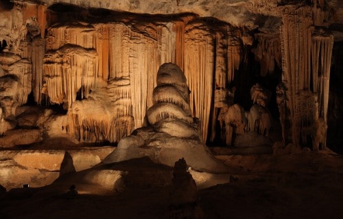
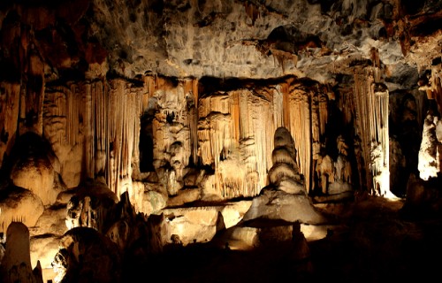
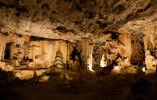
Cango Caves
CCL: https://bit.ly/3h6J4Xy
Cango Caves Facts
- Now showing in this gathering of Africa’s Many Geological Masterpieces is the incredible location that goes by the name of the Cango Caves.
- This breathtaking creation of natural processes goes by the english name that we’ve used here. Perhaps the most noteworthy fact about this site is its sheer status. That’s due to the fact that it’s the most extensive geological feature of its kind in the region.
- Archaeological evidence indicates that prehistoric man also knew of this natural masterpiece. This includes cave paintings and stone artifacts. Many of these date back to the Middle and Late Stone Age. It likely served as a convenient shelter and refuge.
- It appears that local inhabitants of the region forgot about the caves after the Stone Age, however. The rediscovery of the site in modern times occurred in the year 1780. At that time, a local farmer named Jacobus Van Zyl fortuitously stumbled upon them.
- The magnificent site remains one of the most popular tourist sites in the region. Despite this, tourists can only access approximately one-fourth of their extent. Those same tourists can only enter the complex as part of a supervised group, though.
- Exploration of the Cango Caves also remains ongoing. On multiple occasions since their discovery, these explorations added significant features and length to known aspects of the system. The municipality of Oudtshoorn currently manages the site.
CCL: https://bit.ly/3h6J4Xy
Cango Caves Physical Description
The remarkable Cango Caves stands out from many similar features around the world. It does so due to its pure nature. This awesome location boasts an impressive nature. This mainly consist of a series of an extensive series of hidden chambers and connecting tunnels.
Although only a portion remains accessible by the public, the entire confirmed system extends for a respectable distance. Its presently known length measures approximately 2.5 mi (4 km). Indications hint at further features lying beyond this distance, however.
Numerous large chambers exist within its confines. Most of these remain connected by twisting tunnels containing marvelous sights and experiences. The natural chambers vary in size, of course. The largest currently known measures roughly 984 ft (300 m) in length.
An intriguing coincidental aspect of the cave system also exists within its depths. The deepest section of the complex also lies a distance beneath the surface equal to the length of the aforementioned chamber. It’s a remarkable example of naturally occurring symmetry.
Thousands of visually impressive stalagmites and stalactites additionally fill the various chambers within the Cango Caves. The surrounding rock primarily consists of ancient limestone. A small underground river also flows through some of the chambers and tunnels.
CCL: https://bit.ly/2UI96aD
Cango Caves Location, Formation and Exploration
The magnificent Cango Caves formed in a region of the globe already renowned for its abundance of natural wonders. More precisely, it lies in what now constitutes the country of South Africa, in Africa. The nearest town presently sits about 10 mi (16 km) away.
Not surprisingly, given its extent, this complex of caves and tunnels also happens to be quite old. The limestone in which these appear formed during the Precambrian Period. Due to natural processes, the caves and tunnels formed an estimated 20 million years ago.
Like most similar features around the globe, research indicates that this complex formed quite slowly. Apparently, the system originally formed as a series of dripstone caverns. The site still lies in a limestone ridge running parallel to the intriguing Swartberg Mountains.
The first known attempt to formally map the expansive system occurred in 1897. This early effort mapped out a remarkable total of 26 chambers. Much later, the first scientific mapping of the complex was carried out by the South African Speleological Association, in 1956.
Subsequent efforts in 1972 artificially widened a passage to reveal yet another section. This area eventually became known as the equally impressive Cango 2. This section of the Cango Caves stretches a total of 890 ft (271 m). At its ends, however, a body of water existed.
Explorers later drained the water present in the chamber. Doing so thus exposed an obviously unknown passageway. Exploration of that, in turn, led to the discovery of another section, now known as Cango 3. Yet more chambers may lie beyond areas still under water.
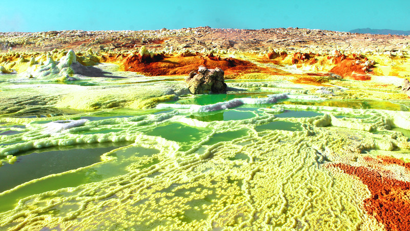
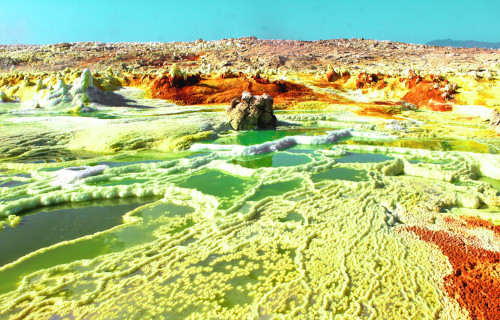
Dallol Hyrdrothermal Field
CCL: https://bit.ly/3Ad8z0O
Dallol Hydrothermal Field Facts
- Placing in the eleventh slot in this composition about Africa’s Many Geological Masterpieces, Dallol Hydrothermal Field does so only due to random selection.
- This breathtaking formation, with its otherworldly vistas, bears the descriptive and informative name that we used herein. The astounding system forms a truly unique creation of natural forces. No other site exactly like it appears anywhere else on earth.
- It remains unknown how long ago local inhabitants of its region discovered it. European settlers, however, first stumbled upon it during their colonizing expeditions. Though no official record exists, this likely occurred in the 17th or 18th century.
- The very nature of both the site itself and that of the surrounding region precluded extensive exploration at that time, though. Even today, scientific studyof the uniuqe creation of Nature, while ongoing, constitutes a complicated and hazardous procedure.
- Its name derives for the language of the Afar people. They comprise the local Indigenous Peoples of the surrounding region. Applied by that group long ago, in their ancient native language the term effectively translates as disinetegration or dissolution.
- Not surprisingly, despite its visual splendor, the Dallol Hydrothermal Field does not represent a tourist draw. That provides it with a measure of protection. The wonder of geology nonetheless remains well known for its eerily captivating color patterns.
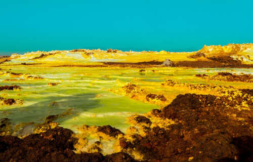
Dallol Hydrothermal Field Physical Description
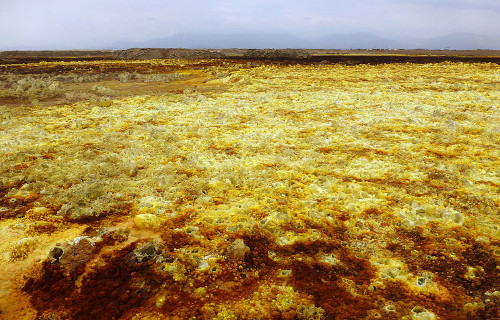
The astounding Dallol Hydrothermal Field immediately entrances those who encounter it with its unearthly sights. Despite its many physical marvels, though, its sheer physical size isn’t among them. That’s because Nature packs all its marvels into a small area.
Its outer perimeter underestandably possesses an extremely irregular boundary. In terms of pure area, though, it measures slightly less than 0.4 sq mi (1 sq km). The seemingly preternatural aspects of the world renowned site make it seem far more extensive, however.
These natural marvels also formed around a central feature. That’s the Dallol volcano itself. This feature boasts a relatively broad shape, averaging around 1 mi (1.6 km) in width. In terms of height, it’s quite shallow. In fact, it only measures 164 ft (50 m) in this regard.
The volcanic mountain in the midst of the Dallol Hydrothermal Field garners its own fair share of appreciation. It’s believed that a circular depression near its center represents a collapsed crater. The banks of the mount hold small pillars and fumaroles.
It’s the area surrounding the volcano that hosts its amazing features, though. These include such fabulous sorts as numerous hot springs, brine pools, multicolored sand deposits, miniature geysers, and even pools of acid! It’s truly like stepping onto another world entirely.
CCL: https://bit.ly/2SBqk8X
Dallol Hydrothermal Field Location, Formation, and Geology
The spellbinding Dallo Hydrothermal Field formed in a region of the globe already well known for its natural marvels. In fact, another equally impressive, albeit in a different manner, natural feature, Erta Ale, lies not far to the northeast of this impressive formation.
That’s due to the fact that, like the other aforementioned wonder, it formed on the continent of Africa. Its geographic location places it within the borders of the country of Ethiopia. The remarkable site further resides in the vast region now known as the Danakil Depression.
Evidence indicates that this marvel formed sometime during what geologists know as the Miocene epoch. This places its origins sometime between approximately 23 – 5.3 million years ago. Experts are still unable to determine its date of origin any more precisely.
Its creation originally occurred due to the intrusion of basaltic magma into the salt deposits of the region. The still ongoing hydrothermal activity seems to have begun sometime later. Minor eruptions actually caused the creation of the small volcano recently, in 1926.
The setting crafted by the Dallol Hydrothermal Field is truly unbelievable, unless one sees it for oneself. Many hot springs secrete brine and other acidic compounds continuously. Small, short-lived geysers manifest at random times and places, depositing cones of salt.
It’s doubtless the vibrant colors of the various deposits that garner the most attention, though. Several impurities, including iron, generate the bright brown, ochre, and yellow shades. Oxidation of older deposits often create the darker brown patches present.
Lake Nakuru
Lake Nakuru Facts
- Our next choice for inclusion in this compendium of Africa’s Many Geological Masterpieces is the remarkable site known as Lake Nakuru.
- The surprisingly simple term given to it serves as the english language name of this magnificent creation of natural forces. The comparatively short moniker also currently represents the only commonly used name for this geological wonder.
- That precise term stems directly from the language of the local Indigenous Peoples. In their language, the word roughly translates as either dusty place or simply dust. The reason for this surprising name, though, remains shrouded in antiquity.
- The magical location wasn’t discovered by outsiders until the early 1890’s. History records that Walter Gregory accomplished that noteworthy addition to science. At time, the Scottish geologist first encountered the lake and surrounding region.
- The stunning Lake Nakuru further represents one of a very unique group of lakes. Collectively, these remain known as the Rift Valley Soda Lakes. Along with the others of the group, it possesses a strongly alkaline nature that sets them apart from others.
- This lake also forms part of Lake Nakuru National Park, an astonishingly beautiful haven for wildlife, including many threatened species. The beauty and importance of this incredible site led to its being protected under the Ramsar Convention.
CCL: https://bit.ly/3tkqyzi
Lake Nakuru Physical Description
The fabulous Lake Nakuru garners much attention from those fortunate enough to visit the site. It further does so for a variety of reasons. Sheer physical size, however, does not rank among those considerations. That’s because it remains a relatively small body of water.
It nevertheless packs a great deal of impressive characteristics into that tiny area. It’s important to note, though, that its surface area varies dramatically. This occurs because the lake has no outflow. Its volume stems directly from rainfall in the surrounding region.
Due to these factors, the surface area of the formation varies quite widely, mostly according to the seasons. This typically ranges from 1.9 – 17.4 sq mi (5 – 45 sq km). Its overall diameter and precise borders also naturally change significantly over the course of the year.
Yet it boasts another physical dimension that’s hard to believe. In this case, that’s the simple depth of the lake. It’s extraordinarily shallow, averaging only 1 ft (0.3 m) in depth! In fact, the greatest measured depth of the lake at any spot only equals roughly 6 ft (1.8 m).
The nature of the water within Lake Nakuru constitutes its most remarkable trait, however. That’s due to the extremely high level of salt and alkaline levels found within its confines. The evaporation cycle present in the surrounding system maintains this distinctive trait.
CCL: https://bit.ly/1jxQJMa
Lake Nakuru Habitat and Wildlife
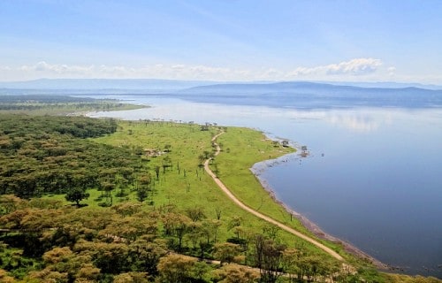
The mind-blowing Lake Nakuru formed in a region of the globe already well known for its abundance of natural wonders. That section of the planet likely comes as no surprise to most people, though. That’s because this remarkable body of water lies within Africa.
More precisely, it formed in what now constitutes the country of Kenya. It additionally lies south of the city of Nakuru, thus the name. This places it within the confines of the Rift Valley. That itself, along with the lake, resides in the approximate southwest of the country.
It’s not precisely known when this amazing location formed. It lies, though, at an altitude of roughly 5,755 ft (1,754 m). In the 1990’s, the water level of the site plunged dramatically. This, however, later recovered. In fact, it later rose to levels unprecedented in recent history.
That’s due to the fact that, in 2013, it received an incredible increase of water levels. Between then and 2020, it surface area temporarily expanded from 15.4 sq mi (40 sq km) to 26.3 sq mi (68 sq km). This resulted in the flooding of hundreds of local homes and park areas.
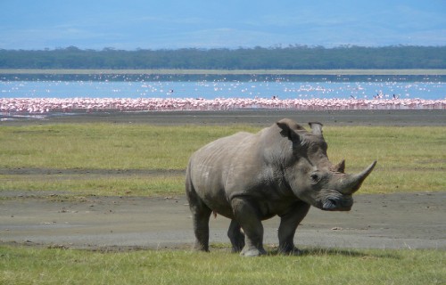
Despite its unusual waters, Lake Nakuru boasts an abundance of life. It remains extremely famous for its avian spectacle. More than 400 species of birds call this marvel of geology and the surrounding park home. Chief among these are two types of pink flamingo.
At times, up to 2 million of these birds stay on the lake at one time. The lake and surrounding park are also home to a myriad of animal species such as a population of both highly endangered black rhino and white rhinos. Cheetahs, lions, and leopards also appear.
Lake Turkana
CCL: https://bit.ly/3qA6w2x
Lake Turkana Facts
- The thirteenth position among this listing of Africa’s Many Geological Masterpieces goes to the fabulous Lake Turkana.
- This intriguing creation of geological processes, with its unusual characteristics, presently most often goes by the english language name. It previously held another name, though. Prior to 1975, the body of water bore the moniker of Lake Rudolf.
- The term it’s now known by honors the main tribe of Indigenous Peoples in the region. In their native language, however, it’s long borne their name for it. In that tongue it’s referred to as Anam Ka’alakol. This loosely translates as the sea of many fish.
- The native population knew of the site for untold centuries, of course. European explorers, however, did not see it for the first time until March 6, 1888. At that time, Count Sámuel Teleki de Szék and Lieutenant Ludwig Ritter Von Höhnel spotted it.
- It stands out from similar features around the world for several reasons. It ranks as both the largest alkaline lake and the largest permanent desert lak on earth. The impressive natural wonder further ranks as the fourth largest salt lake known to man.
- Given its unique nature and importance in the region, Lake Turkana merits special consideration. Due to its multi-faceted role in the area, UNESCO named it a World Heritage Site in 1997. Fortunately, it sees few visitors, helping to maintain its condition.
CCL: https://bit.ly/1p2b8Ke
Lake Turkana Physical Description
The magnificent Lake Turkana fully earns appreciation by those experts who monitor it. Unlike many other similar features, though, it does so for a wide variety of reasons. That’s yet another way in which this body of water distinguishes itself in the annals of science.
Its sheer size certainly qualifies as one of those factors, of course. This varies slightly over time, naturally, due to different reasons. In general, though, it boasts a maximum length of about 180 mi (290 km). The lake also holds a maximum width of roughly 20 mi (32 km).
These dimensions understandably bless it with an impressive surface area. That measures approximately 2,473 sq mi (6,405 sq km). It additionally has a maximum measured depth of 358 ft (109 m). Its average depth, though, measures much less, at just 99 ft (30.2 m).
Incredibly, the center of the lake also plays host to an active volcano! Appropriately named Central Island, this site routinely emits quantities of volcanic ash. This activity accounts for and maintains the unusually high levels of alkaline in the water of the surrounding lake.
The water comprising Lake Turkana also holds yet another wonder. Nature, it seems, decided to work overtime in creating this masterpiece. Due to the extreme nature of the site, the water maintains a surprising temperature. This averages between 81F – 88F (27C- 31C).
It also hosts a striking outer boundary. That’s partly due to the fact that the surrounding rocks are mainly volcanic in origin. Extremely rocky shores and outcroppings dominate much of the southern and eastern shores. Flats and dunes reign to the west and north.
CCL: https://bit.ly/3qBtUws
Lake Turkana Location, Formation, and Ecology
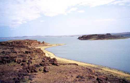
The area in which the remarkable Lake Turkana formed likely comes as no surprise to many people. That’s true since Nature created it in a region of the world well known for its natural marvels. More precisely, the impressive site lies in an amazing part of the continent of Africa.
Due to its great size, though, it actually formed within the boundaries of two separate countries. The greater part by far sits inside the borders of Kenya. A relatively small portion of it also crosses into neighboring Ethiopia. It’s also a 2-day drive from Nairobi.
This tantalizing geological marvel actually owes its formation and continued presence to a unique combination of factors. Amazingly, a total of three rivers actually flow into the basin where it sits. These themselves bear the names of the Turkwel, Omo, and Keiro Rivers.
That in itself isn’t particularly remarkable, it’s true. What is, though, is the fact that not a single one of them flows out of the lake! The only loss of water the lake suffers occurs due to evaporation. Only the great heat and general aridity of the region maintains a balance.
Due to inaccessibility, temperature, and aridity, Lake Turkana continues to retain its wild character. Nile crocodiles inhabit the lake in abundance, and scorpions and carpet vipers live in numerous around the shores. Hundred of bird species also make this site home.
A wide range of mammals also live around the lake. These include such species as zebras, gazelles, and giraffes. Their predators also appear, including cheetahs and lions. Plankton also lives in its waters. Despite its acidity, this allows a few fish species to thrive as well.
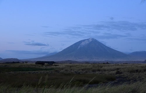
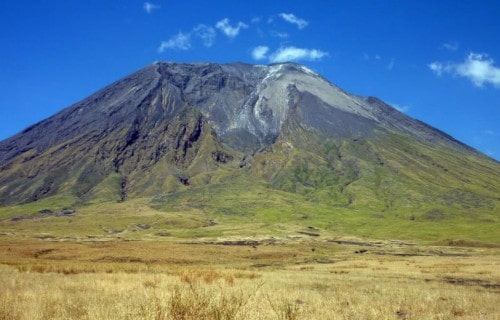
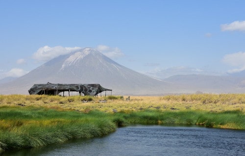
Ol Doinyo Lengai
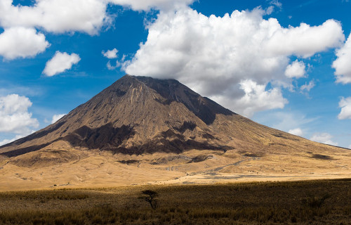
CCL: https://bit.ly/3dxridz
Ol Doinyo Lengai Facts
- The next location we’ve added to this gathering of Africa’s Many Geological Masterpieces is the magnificent Ol Doinyo Lengai.
- The term given to it serves as the most commonly used name for this true masterpiece of geological processes. But that term represents the english language translation of its name in the native tongue of the original inhabitants of its region.
- Two local groups of Indigenous Peoples share that common language. In the native tongue of the Maasai and the Sonjo, the term translates as The Mountain of God. They also use other terms, though, such as Basanjo, Donjo Ngai, and Mongogogura.
- Regardless of which moniker one uses, it’s an impressive natural feature. It also merits appreciation for its uniqueness. That’s due to the special attributes of the lava it produces. These easily rank it as one of the most unusual volcanoes on the planet.
- Due to its unique nature, the lava spewed forth by Ol Doinyo Lengai displays astonishing patterns. It’s initially black or brown in color. Within days, or sometimes only hours, however, it changes color. After that time, it changes to a snow-like white!
- Yet another quality of its flows distinguishes it from other volcanoes. Its flows are also highly liquid compared to others. In fact, these remain the most liquid like of any known such flows. These also emerge at significantly lower temperatures than others.
CCL: http://bit.ly/2xQPH8p
Ol Doinyo Lengai Physical Description
The fabulous Ol Doinyo Lengai easily merits attention and appreciation by the viewer. It further does so for a variety of reasons. The site’s not the largest of its kind around the world, of course. Yet, its physical dimensions certainly qualify it as an impressive volcano.
The site boasts a remarkably rounded and even cone shape structure. The intriguing mountain also rises to a respectable height above the surrounding terrain. This aspect of the site makes it clearly visible over great distances. It stands an impressive 5,900 ft (1,800 m).
Each side of the summit of the mountain additionally features a large crater. These remain separated by a ridge measuring approximately 360 ft (110 m) in length. Despite such close proximity to each other, the two craters displays striking different appearances.
The one on the southern flank appears to be completely inactive. This sometimes fills with water. The other crater, however, presents a vastly different view. It’s routinely covered in fresh lava flows. It also regularly forms small, temporary cones that produce lava.
Ol Doinyo Lengai further manifests several parasitic vents. These smaller formations appear on its flanks. Presently, four of these exist on its slopes. The western flank also displays large, deep fractures. Large debris fields dot its sides as well, from earlier events.
It’s the lava itself that ranks as its most unique structure, however. This stratovolcano produces eruptions with an incredibly low silica content. Its composition consists of more than 50% carbonate, even though this compound rarely appears on the earth’s surface.
Public Domain Image
Ol Doinyo Lengai Location, Formation, and Importance
The location of Ol Doinyo Lengai probably won’t surprise many of you. That’s because this wonder of geological processes formed in a region of the world well known for its natural marvels. That’s due to the fact that it formed on what’s now the continent of Africa.
There, it lies in the approximately southeastern section of the continent. That location places the formation with the boundaries of the country of Tanzania. Within that area, the volcano lies in the more northerly portion of the country, above the Serengeti.
The mountain itself forms an integral part of the East African Rift Valley. Geological research indicates that this continental rift began forming around 1.2 million years ago. Over time, the resulting thinned crust allowed for the formation of the site as it’s seen today.
Though far too infinitesimally slow for human observation, this expansion continues today. Such ongoing movement generates the heat that still maintains the activity of the mountain. This continued movement by the rift proceeds at a leisurely 0.12 in (3mm) per year.
The mighty Ol Doinyo Lengai has much to offer. It plays a vital role in the overall health of the surrounding ecosystem. Its unique lava actually breaks down quickly when it rains. The resulting runoff has helped lead to the remarkable verdure of the entire region.
It’s importance doesn’t end there, though. That’s true since it’s also quite important to research. Carbonatite, which it produces, remains invaluable to the study of rare earth elements. This site represents the only actively producing source of these elements.
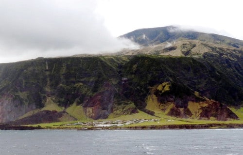
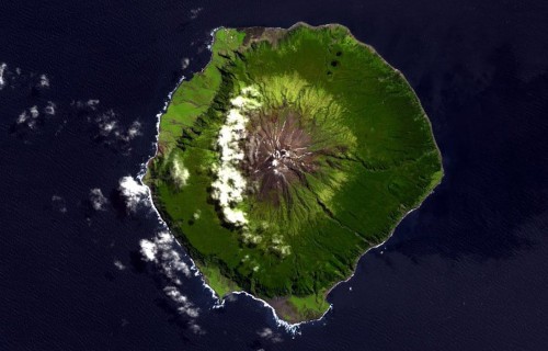
Tristan da Cunha
CCL: https://bit.ly/3dxeFP
Tristan da Cunha Facts
- Making this article about Africa’s Many Geological Materpieces, the incredible Tristan da Cunha lists in the fifteenth position.
- By any name used, this site actually holds several distinctions. That’s because it serves as the moniker for both an island and an archipelago. To the local population, though, both forms of this marvel of geology simply bear the name of Tristan.
- It’s presently unknown if ancient man ever knew of its existence, though it’s considered likely. In more modern times, however, European explorers were the first to locate it. Portuguese explorer, Tristão da Cunha, recorded the first known sighting.
- He noted that at the time, despite the fact that rough weather prevented making a landing. The explorer subsequently named the formation after himself. His original term for the collection of islands, later anglicized, was Ilha de Tristão da Cunha
- Reports exist of landings on the site by the Portuguese as early as 1520. These, remain unconfirmed, though. The first undisputed landing, however, occurred in 1643. This took place on February 7, 1643, by the crew of a Dutch East India Company ship.
- This remote location, and the accompanying islets, forms a British overseas territory. It’s still extremely sparsely populated,depsite this. Currently, the entire population of the main island of Tristan da Cunha numbers only 266 permanent residents.
CCL: https://bit.ly/3h4PI0m
Tristan da Cunha Physical Description
The stark, pristine formation of geological processes known as Tristan da Cunha clearly deserves full appreciation. That holds true for both the main island and the namesake archipelago. Sheer physical size, however, doesn’t qualify as one of those reasons.
That’s true since even the main island itself remains comparatively small in dimensions. The primary island of the grouping itself only has a dimatere measuring roughly 6.8 mi (11 km). Its irregular outline provides it with a total area of just over 38 sq mi (98 sq km).
Six other islands comprise the remander of the archipelago. Only one, though, named Gough Island, compares this one in size. It’s only 3.2 sq mi (8 sq km) smaller in total area. The remaining five islands of the collection actually total less than 8 sq mi (20.7 sq km).
The terrain of the main island itself is quite mountainous in nature. Despite the small size of the island, though, the highest point on the site consists of an impressive volcano. The summit of this active peak, named Queen Mary’s Peak, measures 6,765 ft (2,062 m).
In fact, just one comparatively flat section of any reasonable size exists on the entire primary island, Tristan da Cunha itself. That lone spot sits on the approximate northwest coast. It’s also site of both the only agricultural area and the sole settlement on the island.
The remaining portions of the collection have mostly inhospitable and desolate landscapes. A few small, rocky beaches exist between them, though they’re all relatively rocky. At just 25 acres each, two of them represent little more than small rocks jutting up from the sea.
Public Domain Image
Tristan da Cunha Location, Formation, and Ecology
Defining the location of the magnificent Tristan da Cunha isn’t as simple a proposition. That’s because it formed in an incredibly remote portion of the globe. It’s so remote, in fact, that it qualifies as the most isolated inhabited archipelago on the entire planet.
Due to this truly extreme situation, the nearest inhabited area lies nearly 1,200 mi (1,931 km) away! That location itself also consists of a single, small, sparsely populated island. The astounding formation of small islands lies in a section of the Southern Atlantic Ocean.
For better reference, its location places it roughly 1,732 mi (2,787 km) from Cape Town, South Africa, on the continent of Africa. Geologists still remain uncertain of the precise factors behind its formation. An uplifting of mantle forms the leading theory.
All parts of the gathering of islands possess a distinctive climate. That consists of an unusual oceanic climate. Temperatures stay generally pleasant, while rainfall’s most often moderately heavy and quite consistent. Temperatures stay mild sunshine limited.
The presence of a strong, nearly constant westerly wind augments its weather conditions. These conditions all naturally play a role in the nature of the local ecosystem. Despite the conditions, numerous species of trees, ferns, mosses, and flowering plants appear.
Yet, Tristan da Cunha is best known for its fauna. A total of 13 known bird species call the islands home. Due to this fact, it’s listed as an Important Bird Area. The waters surrounding it teems with a rich variety of species. This especially includes whales and dolphins.
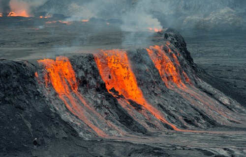
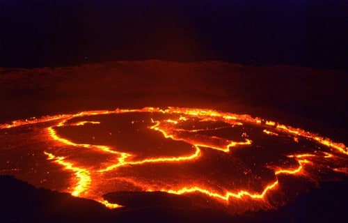
Erta Ale
CCL: http://bit.ly/2IjEG4n
Erta Ale Facts
- This spellbinding addition to this collection of Africa’s Many Geological Masterpieces, with its otherworldy aura, is named Erta Ale.
- That short term inadequately serves as the english language name for this spellbinding creation of naturally occurring geological forces. Like many such incredible features around the globe, it does have another, previously used moniker, though.
- It orgininally bore the name of Irta’ale in the native language of the indigenous population of its region. The commonly used title for the feature translates as smoking mountain. It comes from the native tongue of the local Indigenous People, the Afar.
- Obviously, the original inhabitants of the area have known of its existence for untold centuries. It’s unclear precisely when the first non-natives first spotted it, though. But, reports of sightings by various European explorers date back to the 16th century.
- Those reports, however, only mentioned the volcano itself. The most remarkable individual characteristic of the mountain, though, wasn’t reported until 1960! It’s believed that this, an extraordinary lava lake, formed about 107 years ago.
- Unfortunately, researchers still have only a very limited knowledge of Erta Ale. The terrain in the immediate area remains considered some of the most inhospitable in the world. This makes access to the site both extremely difficult and dangerous.
CCL: https://bit.ly/3jx2c2r
Erta Ale Physical Description
The eerily magnificent Erta Ale is an indescribably unique location. In some ways it’s an utterly unique formation. It therefore draws a great deal of interest for its natural wonders. The site garners such intense interest due to a combination of remarkable aspects.
Though certainly not the tallest volcano currently known to man, it nonetheless boasts a respectable size. In its present state, the mountain stands roughly 2,011 ft (613 m) tall. The base of the impressive formation also has an astonishing diameter measuring 31 mi (50 km)!
The caldera of this natural wonder further holds correspondingly attention-grabbing dimensions. This part of the awesome site’s roughly rectangular in shape. It measures approximately 1 mi (1.6 km) in length. Its width also stands out, at about 0.43 mi (0.7 km).
Simple size isn’t the only tantalizing aspect of the caldera, though. That’s because this itself holds two pit crater within it. Evidence indicates that both of these have often held lava lakes throughout its history. Only seven other volcanoes on earth host such active features.
The largest of the two of these within Erta Ale has a width of roughly 1,148 ft (350 m). It’s also about 656 ft (200 m) deep. The southern of the two ranks as the smaller of the pair. It’s roughly 328 ft (100 m) in depth. The measured diameter equals about 213 ft (65 m).
Though smaller than its companion, it’s by far the most famous. This stands out as the longest continually active feature of its kind known to science. Its longevity and unearthly appearance remain unlike any other. This garnered it the popular name of Gateway to Hell.
CCL: http://bit.ly/2zBWbKi
Erta Ale Location, Formation, and History
The location of the otherwordly creation of time and geological activity known as Erta Ale doesn’t surprise many people. That’s due to the fact that it formed in a part of the world widely known for its natural wonders. Nature provided the region with countless such.
More precisely, the volcanic mountain formed on what’s now known as the continent of Africa. It’s centered over what’s popularly known as the East African Rift. That places it in the Afar Region of northeastern Ethiopia. It also locates it within a local desert.
It’s very formation further distinguishes the mountain from other sites of its kind. That’s due to the fact that it’s the product of a triple junction of tectonic plates. To the present knowledge of geologists, this is the only place on earth where such a conjunction happens.
The movement of these plates creates the forces responsible for its many unique traits. The distinctive mount lies 246 ft (75 m) below sea level, because of the downward thrust of one of the plates. The mountain itself’s comprised of material slowly pushed upward.
Haunting yet captivating Erta Ale holds its share of perils, though, to be certain. Though far less common than its continued slow activity, eruptions do occur sporadically. In August of 2007, a flow escaped the crater, forcing an evacuation of hundreds of local residents.
Explosive eruptions also happen sometimes. In both 2008 and 2017 scientists reported these occurring. The last major eruption took place on September 25, 2005. During this event, thousands of inhabitants fled, two disappeared, and several hundred cattle perished.
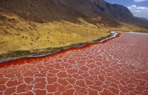
Lake Natron
Lake Natron Facts
- The seventeenth position in this article about Africa’s Many Geological Masterpieces goes to the incredible body of water named Lake Natron.
- This stunning creation of natural forces bears the deceptively simple name used here. But only the name qualifies as simple, though. That’s true since it ranks as a true marvel of Nature. It also boasts highly unusual physical properties.
- Its name belies its nature, though. The formation holds this title due to those same qualities. It’s named after a mineral known as natron. That’s an amalgamation of the chemicals forming hydrate sodium carbonate and sodium bicarbonate.
- This compound remains present in the body of water in prodigious quantities. The very distinctive chemical properties of the body of water have fascinating effects on the surroundings. At times, its contents are almost as caustic to the touch as ammonia!
- No record exists of how long the local Indigenous Peoples knew of its existence. It’s likely they long knew of its presence, however. This wonder of the earth remained completely unknown to the outside world, though, until its discovery in 1954.
- Today, the incredible attributes of Lake Natron justly earn it full appreciation. Despite the seeming inhospitableness of the site, it represents an important wetland within its region. That’s clearly acknowledged by its present listing as a Ramsar Site.
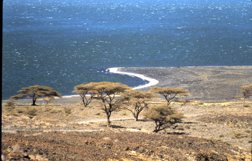
- This marvel of the world resides in a region full of other wonders. That’s because it formed on the continent of Africa. It sits in the East African Rift, like Ol Doinyo Lengai. More precisely, it lies within the current borders of the country of Tanzania.
CCL: https://bit.ly/3dx5X48
Lake Natron Unique Flora
One might think that the extreme conditions within Lake Natron would rended it devoid of life. Intriguingly, however, the reverse is actually the case. In its on way, this fabulous combination of conditions teems with life, albeit highly specialized types.
The microbiology of the body of unusual water remains dominated by salt-loving organisms. Given the high levels of this compound present, these thrive in vast quantities. Several species of these appear in the lake. The most prevalent one, though, is known as spirulina.
This cyanobacteria makes its own food, utilizing photosynthesis. One of the chemical compounds, an accessory to the process, is a bright red pigment. It’s this that creates the incredible eye-catching red blood-red hues for which the site’s perhaps best known.
The extremely high evaporation rate of the waters of Lake Natron maintain this ecosystem. That’s because such a remarkable rate generates very high salinity levels. A thin, alkali salt crust forms on the surface, serving as the perfect environment to sustain the bacteria.
CCL: http://bit.ly/2JszWtI
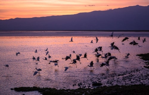
Lake Natron Wildlife
Despite the conditions of and immediately surrounding Lake Natron, bacteria aren’t the only life there. A surprising variety of fauna also calls the formation home. In the somewhat less salty, as well as slightly cooler regions around the edge, a few fish even survive.
Two species of these appear natively, in addition to one not endemic to the lake. The native varieties consist of tilapias. They bear the unoriginal names of wide-lipped Natron tilapia, and the narrow-mouthed Natron tilapia. When the invasive one appeared is unknown.
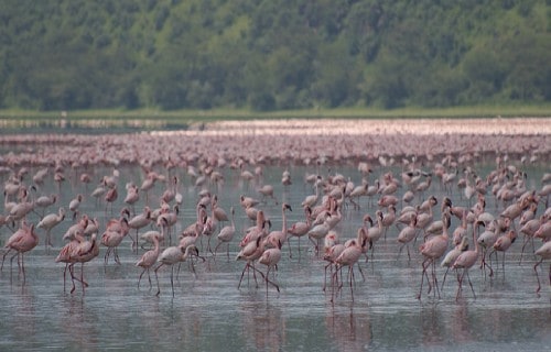
A few hardy types of invertebrates also make their home here. Yet, the most visible inhabitant of the region is astonishing. That’s due to the fact that this site serves as the sole breeding ground for the 2.5 million lesser flamingoes. They depend on this one region.
They feed voraciously on the specialized bacteria present in Lake Natron. Indeed, it’s the red algae they consume that creates their trademark pink hue! Special evolutionary adaptations make it possible for them to survive and feed here. The conditions also limit predators.
Lake Natron Threats and Preservation Efforts
Lake Natron represents a truly geologically unique and vitally important habitat. Unfortunately, the few species adapted to its unique environment cannot survive elsewhere. That very adaptation, however, leaves them extremely vulnerable to a wide range of threats.
Sadly, projected logging activities currently threaten to disrupt the delicate salinity balance of the lake. A hydroelectric plant on the Ewaso River is under consideration. Both of these projects are posed to severely affect the delicate environmental balance of the lake.
A proposed soda ash plant at the site, suggested for one shore, also constitutes a threat. This plant would extract sodium carbonate from its waters. That’s one of the key components of the unique attributes of its water. The lesser flamingoes, however, could not feed on it.
Efforts to protect and preserve Lake Natron do exist, though. These efforts remain ongoing, yet need more support. Dozens of preservation societies and environmental organizatios spearhead these efforts. Birdlife International represents one of the leading proponents.
Eye of the Sahara
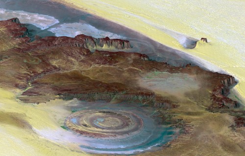
Public Domain Image
Eye of the Sahara Facts
- Next up among our selections to appear in this compilation of Africa’s Many Geological Masterpieces is the mysterious Eye of the Sahara.
- This mind-blowing creation of geological processed most often goes by the attention-grabbing name for understandable reasons. That’s not the only moniker applied to it, though. That’s because it’s also called the Guelb er Richât and the Richat Structure.
- Regardless of the term one chooses to use, though, it remains an incredible feature. It’s also a source of some controversy among researchers. Although the preponderance of evidence indicates a terrestrial origin, some still think it’s an impact crater.
- Incredibly, this extraordinary geological feature was actually unknown to man until it was accidentally spotted from space. Between its extreme remoteness and its sheer size, no one noticed its uniqueness before, even when passing through it.
- Credit for its discovery as a unique structure goes to two astronauts. During their Gemini 4 mission, they noted the structure by accident. Astronauts White and McDivitt share credit for this highly fortuitous discovery within the annals of science.
- Yet, the aptly-named Eye of the Sahara isn’t only famous for its physical distinctiveness. That’s true due to the many remarkable items found there. The site also contains an extraordinary collection of stone tools dating back as far as 1.7 million years ago.
- Accordingly, the site holds a respected status for this, as well. Due to the existence of such an unparalleled find, it received numerous accolades. The International Union of Geological Sciences chose it as one of the first 100 geological heritage sites.
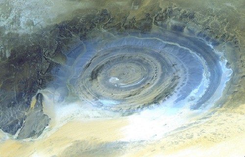
Eye of the Sahara Physical Description
The amazing Eye of the Sahara immediately captivates all those who learn of it. Obviously, its sheer appearance represents an intriguing sight for many individuals. But, the sheer physical dimensions of this natural marvel nevertheless equally astounds the informed.
The formation boasts a roughly circular shape, with slightly irregular outlines. Overall, it holds a diameter that measures a stunning 25 mi (40 km). It’s also composed of several concentric rings. The largest of these, the central area, is roughly 19 mi (30 km) in diameter.
Each of its rings manifests a wall, called a dike. The inner ring dike averages 65.6 ft (20 m) thick. It sits about 1.9 mi (3 km) from the approximate center. The outer ring wall, though, is larger, at roughly 164 ft (50 m) thick. But it lies about 4.3-5.0 mi (7-8 km) from the center.
A wide variety of rock structures also appear within the various sections of the Eye of the Shara. These include differing volcanic rocks, gabbros, carbonatites, and kimberlites. Many of these seem to have originated from ancient lava flows within the awesome structure.
Nature didn’t simply stop there, though, when creating this masterpiece. As if these weren’t enough, numerous hydrothermal features also exist inside he confines of the site. These include a multitude of formations consisting of sandstone, silica, and limestone.
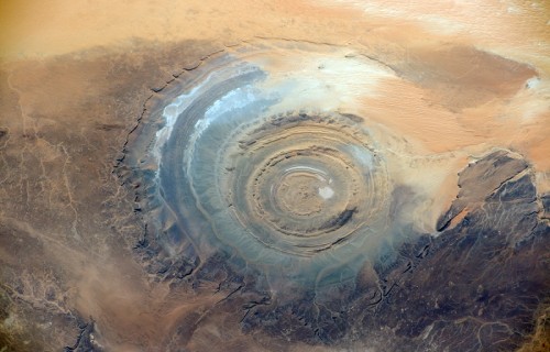
Public Domain Image
Eye of the Sahara Location, Structure, and Mysterious Origins
The location where the mesmerizing Eye of the Sahara formed probably won’t surprise many people. That’s true since it lies in a region of the world already quite well known for its abundance of natural marvels. The site sits on what’s now the continent of Africa.
What’s more, its location’s also extremely remote. This aided in its eluding discovery until modern times. It’s to be found in the western section of the country of Mauritania. This, as the common name clearly indicates, places it in the equally fascinating Sahara Desert.
Situated in the northwestern section of that continent, it’s further located inside another remarkable place. That amazing feature itself remains known, especially locally, as the Adrar Plateau. In the country it appears in, this puts it in the western central portion.
The Eye of the Sahara represents what scientists call an elliptical dome, albeit a highly eroded one. Several distinct layers of sedimentary rocks appear inside its walls. A wide variety of minerals are present, as well. These include limestone and quartz-rich sandstone.
It’s widely believed by the majority of geologists to be the result of uplift. Evidence indicates that its creation began approximately 100 million years ago. Studies undertaken in the 1950’s and 1960’s, in the minds of most researchers, disproved the impact theory.
Ngorongoro Crater
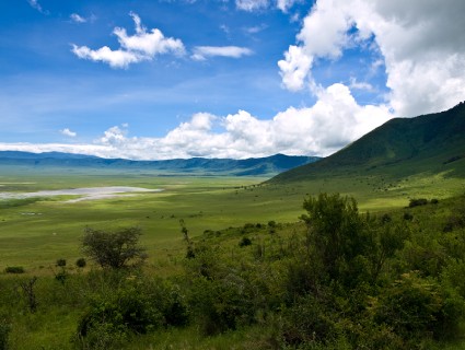
Ngorongoro Crater Facts
- The nineteenth spot in this listing of Africa’s Many Geological Masterpieces goes to the magnificent Ngorongoro Crater.
- This breathtaking creation of geological forces remains best known by the somewhat hard to pronounce term that we use here. It stands out due to the fact that it represents the largest inactive, intact, and unfilled volcanic caldera on earth.
- Evidence indicates that this masterpiece of Nature formed somewhere between 2 – 3 million years ago. This occurred due to the powerful explosion of a large volcano. The remnants of the mount subsequently collapsed inward, forming the site as it is now.
- Researchers currently estimate that the original volcano boasted a height between 14,800 – 19,000 ft (4,500 – 5,800 m). The formation as it exists now boasts some truly impressive phsyical dimensions. Its floor measures roughly 2,000 ft (610 m) in depth.
- The crater remains relatively circular in shape. It also measures about 12.4 mi (20 km) in diameter. The floor of this remarkable product of natural forces also distinguishes itself. That’s because it covers an area of about 100 sq mi (260 sq km).
- That same portion of Ngorongoro Crater further separates itself from similar features. The crater does so due to yet another surprising characteristic. The tantalizing wonder of geology lies at an elevation of around 5,900 ft (1,800 m) above sea level.
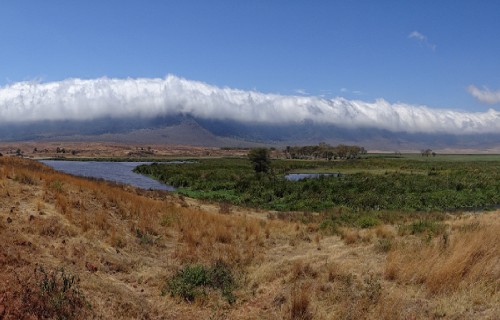
Ngorongoro Crater Wildlife
The lush setting of Ngorongoro Crater literally teems with life. This includes both plants and animals, to be certain. Yet it’s the fauna that make their home here that garner the most attention. These comprise in an incredible variety of animals, both large and small.
Roughly 25,000 large animals live within its confines. Ungualtes comprise the majority of these, though. This population includes such animals as the black rhino, hippo, and the cape buffalo. Wildebeests, zebras, elands, gazelles, and other herbivores also appear.
A relatively large lake also exists in the southwestern portion of the beautiful formation. Named Lake Madagi, it’s frequently filled with large numbers of lesser flamingoes. Other avians also appear in small numbers. One endangered species of shrew also lives there.
Intriguingly, many other creatures common to this part of the world remain abent. Whether that’s coincidental or due to some unknown factor remains undetermined. Impala, giraffe, oribi, and topi do not live here. Among predators, crocodiles are curiously absent.
Given the presence of so many potential prey species, many predators call the location home, too. It holds one of the densest known population of lions. They’re not the only large feline present, though. Servals additionally dwell in comparatively large numbers here.
Some additional creatures do appear in Ngorongoro Crater sporadically, however. These include such creatures as the African leopard, East African wild dog, and the cheetah. Some of the many animals here seem to migrate in and out of the amazing site, as well.
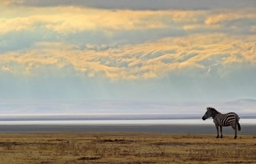
CCL: https://bit.ly/1p2b8Ke
Ngorongoro Crater Location, History, and Preservation
The location of the magical Ngorongoro Crater suits it perfectly as a backdrop for its wonders. That’s due to the fact that it formed in a region of the globe renowned for its many natural marvels. More specifically, it sits on the already impressive continent of Africa.
There, it formed on the approximate southeastern section of the landmass. That location places it inside the boundaries of the country of Tanzania. It further sits roughly 110 mi (177 km) west of Arusha City. This places it in the aptly-named Crater Highlands of the country.
Archaeological evidence indicates that prehistoric man knew of this wonder in the far-distant past. Fossil discoveries show that various hominid species have occupied the region for more than 3 million years! Pastoralists replaces hunter-gathers a few thousand years ago.
In more modern times, the Mbulu arrive in the region around 2,000 years ago. The Datooga joined them around 1700 years later. Yet another Indigenous People displaced both in the 1800’s. That group, the Maasai, still inhabit the immediate area of the site.
Efforts to preserve and maintain the vital Ngorongoro Crater remain ongoing. For one, it now forms part of the namesake Ngorongoro Conservation Area. In fact, this entire marvel of geology presently officially qualifies and lists as a UNESCO World Heritage Site.
Africa’s Many Geological Masterpieces
We hope that each of you enjoyed reading, and hopefully learning from, this article we’ve written about Africa’s Many Geological Masterpieces. It’s also our hope that doing so has left you with either a new or renewed appreciation for such wonders of Nature.
Unfortunately, however, many such features around the world now find themselves facing strong threats to their continued existence as in their natural state. Many of those dangers, in fact, stem from the actions of mankind. We must do all we can to protect and preserve them.
Check out our other articles on 3 Bewildering Birds of Africa, Spectacular Dolphins Throughout Our World, 5 Intriguing Insects of Greece, 7 Breathtaking East Coast Wonders
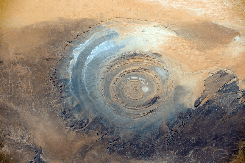