


Victoria Falls Facts
- The natural marvel known as Victoria Falls remains one of the most spectacular sites on earth. That’s the name applied to it by European explorers, however. The local Indigenous Peoples named it Mosi-oa-Tunya, meaning The Smoke that Thunders.
- The renowned Scottish explorer and missionary, Stanley Livingstone, became the first known European to encounter it. That history setting event occurred on November 16, 1885. Evidence indicates, however, that locals knew of it as far back as the Stone Age.
- The combination of its extreme width and height earn it a place in the record books. These statistics qualify it as one of the largest waterfalls in the entire world. As a result, UNESCO currently lists this wonder of Nature as a World Heritage Site.
- Somewhat ironically, though not surprisingly, another waterfall bears the exact same name. This one, located in Scotland, in Europe, however, though lovely, holds no comparison in terms of size. Both bear their names in honor of Queen Victoria.
- The better known Victoria Falls now finds itself facing severe threats. Environmental conditions related to climate change threaten its natural existence. Steadily increasing temperatures have begun to dramatically and steadily reduce the water flow.
Related Articles

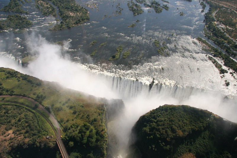
Victoria Falls Physical Description
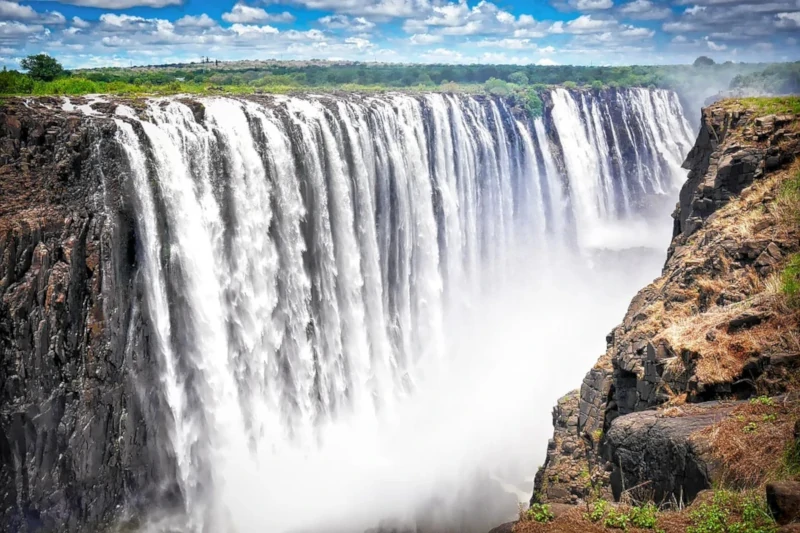
Despite its great and fully deserved fame, the wondrous Victoria Falls isn’t either the widest or tallest known waterfall. Its combined physical statistics nevertheless make for a truly impressive example of the work of Nature. It’s also a breathtakingly beautiful site to behold.
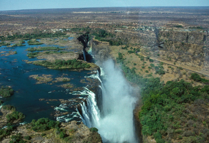
The precise width of the body of water actually varies, due to the inflow of water. That variation, however, until recent years, always remained proportionately minor. On average, though, this stunning waterfall boasts a width of roughly 5,604 ft (1,708 m).
Its measured height of approximately 354 ft (108 m) also makes it nearly twice as tall as Niagara Falls, in North America. The combination of its height and width provides it with what’s generally regarded as the single largest sheet of falling water on earth.
Two small islands also appear in the flow, situated quite close to the edge of Victoria Falls. These do, however, remain large enough to divide the flow of water, even during extreme flow. These features bear the names of Boaruka Island, and Livingstone Island.

Victoria Falls Location, Formation, and Ecosystem
In a twist of irony, the staggering Victoria Falls formed in a region of the world usually associated with aridity. That’s because this wonder formed in a portion of the continent of Africa. More precisely, though, it lies in what now forms the country of Zimbabwe.
This feature, itself worthy of note, further represents part of the Zambezi River. In the distant past, however, the river followed an entirely different route. A gradual but steady upward movement of the land about 2 million years ago, altered that to its current course.
Evidence also indicates that its course could be in the process of changing again. That’s due to the fact that a portion of one edge of the western bank seems to be eroding. This section currently carries the greatest concentration of the flow rate during flooding.
Two small but vital National Parks presently lie along its banks. These bear the names of Victoria Falls National Park, and Mosi-oa-Tunya National Park. Though locally important, both nevertheless have a combined total area of only around 33.9 sq mi (89 sq km).
These contain large numbers of wildlife, both in species and individuals. This includes sizeable populations of Cape Buffalo, giraffe, elephants, lions, and several types of antelopes. Smaller but relatively significant numbers of leopards and cheetahs also appear here.
Vervet monkeys also live within the parks in large numbers, along with various baboons. Crocodiles and hippos additionally thrive in the waters approaching the beautiful Victoria Falls. Dozens of species of birds, including raptors further inhabit the parks.
The surrounding environment, meanwhile, mostly consists of mopane woodland savannah. Less sizeable, but nonetheless important, areas of woodlands and scrubland also dot the surrounding region. A thriving rainforest also appears, due to the moisture.
![Victoria Falls - Mosi-oa-Tunya, Zambia & Zimbabwe [Amazing Places 4K]](https://i.ytimg.com/vi/iywqpda7d8k/hqdefault.jpg)
Features Sharing Its Region
Check out our other articles on 5 Spectacular North Carolina Spiders, Black Rain Frog, Kapok Tree, Grizzled Mantis, Spiny Dogfish, Rusty-Spotted Cat, Hyacinth Macaw, Jackson’s Chameleon