CCL: https://bit.ly/2U88ISI
It’s our sincere hope that each of you, our readers, will truly enjoy and appreciate this article we present about these 5 Intriguing Islands of Australia. It was certainly our great pleasure to gather the various information for you. May it provide you with both education and increased awareness.
Certainly, these few sites listed herein, while wondrous, nonetheless represent only a small portion of the wonders found throughout this amazing region. It’s our belief, though, that they serve as excellent representations of the marvels found here. Check out some of our other articles, as well.
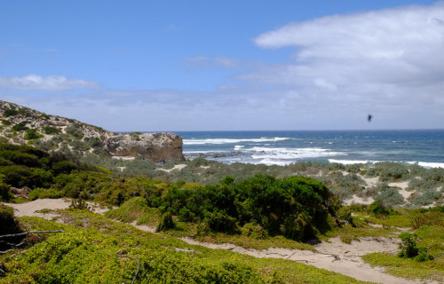
Kangaroo Island
CCL: https://tinyurl.com/22y23f9m
Kangaroo Island Facts
- Starting off this article about these 5 Intriguing Islands of Australia comes one that jumps out at you, the aptly-named Kangaroo Island.
- This breathtaking creation of time and geological forces most frequently goes by the distinctive english language name used for it here. Somewhat uncommonly, for the moment, this magnificent location does not yet possess any other broadly accepted general titles.
- Yet, this feature does have another moniker, albeit one much less known. That’s actually the original term for the marvel of geology. In the ancient native tongue of the local Indigenous Peoples, the Kaurna, it holds a tag that translates as Karta Pintingga, or Island of the Dead.
- It’s unclear to researchers exactly when the ancestors of the Kaurna population first settled the island. Archaeological evidence indicates, however, that this occurred sometime around 16,000 years ago. It’s currently believed that the last native inhabitant left about 2,000 years ago.
- Rising sea levels apparently precipitated this mass human exodus. This process began occurring approximately 10,000 years ago, due to the receding of ice from the last ice age. That rise cut this area off from the mainland, turning it into the fabulous island it exists as today.
- History credits captain Matthew Flinders as the first known European explorer to spot the site, though. This notable event took place when he landed on the northern coast, in March of 1802. Very soon after, whalers and sealers began establishing various temporary settlements.
- Fortunately, despite the undeniable beauty and numerous attractions possessed by Kangaroo Island, tourism still remains manageable. Several extensive Nature Reserves additionally serve to protect large portions of the island. Flinders Chase National Park ranks as the largest.

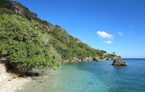
Photo: Marcello Saponaro
CCL: https://tinyurl.com/22y23f9m
Kangaroo Island Physical Description
Much like its namesake, the natural beauty of Kangaroo Island literally jumps out at those individuals fortunate enough to visit the stunning site. That’s simply because Nature blessed it with an abundance of natural marvels. The formation also boasts some highly respectable dimensions.
Its shape’s considered rather difficult to describe in so many words, though. That’s primarily roughly rectangular, with a small, thin, highly elongated extension situated at one end. This peninsular section of the island measures actually less than 0.6 mi (1 km) in width at one specific point.
Including this projection, the island holds a length totaling roughly 90 mi (144.8 km). Yet, at its widest point the mesmerizing geological wonder has a width of about 34 mi (54.7 km). Taken together, these measurements provide the formation with a total area of 1,701 sq mi (4,405 sq km).
The coastline of this beautiful creation of powerful natural processes also has its own highly irregular structure. This nature serves to generate a significantly greater extent of coastline than one might think. That’s because the perimeter of the site runs for an impressive 336 mi (540.7 km).
Yet, the purely physical marvels of the breathtaking Kangaroo Island do not simply end there. This mesmerizing location also contains numerous other structures and features to merit appreciation. These include several small mountains, with the highest standing about 1,007 ft (307 m).
Other spectacles of geological origin present include multiple pristine beaches and several intriguing rock formations. The best known of these bears the appropriate name of Remarkable Rocks. Magnificent bays, such as Vivonne Bay and Emu Bay further add to its undeniable allure.

Photo: Christian Wittmann
CCL: https://tinyurl.com/bde6zfd3
Kangaroo Island Location, Formation, and Ecology
The visually captivating Kangaroo Island formed in a region of the world already extremely renowned for the presence of other natural wonders. That region of the earth’s surface likely won’t amaze anyone, though. That’s because this amazing island formed just off the coast of Australia.
More precisely, the wonder of Nature lies off the south-southeast side of the continent. In fact, its precise location puts it a mere 8.4 mi (13.5 km) from the closest projection of the larger landmass, known as Snapper Point. This further places it roughly 70 mi (112 km) southwest of Adelaide.
The formation of this visually appealing section of the our beautiful planet truly began as a result of the aftermath of the last great ice age. Prior to the slow melting of the massive amounts of accumulated ice, this area was actually contiguous with what’s now the neighboring landmass.
That inexorable action occurred due to the enormous increase in the depths of the world’s oceans that created. So great was the quantity of water contained within the ice that its melting raised the sea level roughly 394 ft (120 m) globally. It rose at a rate of about 3.3 ft (1 m) per century.
The magnificent site of Kangaroo Island further possesses a warm-summer Mediterranean climate. Due to that, life abounds here, both flora and fauna. Among flora, scientists have recorded 891 species of plants native to the island. These include varieties of grasses, several orchids, and trees.
The site also teems with animal life. This includes birds, such as the Little Penguin, along with multiple other species. Several amphibians also live on the island, in addition to bats. The place remains best known, though, for its thriving kangaroo population, thus the distinctive name.
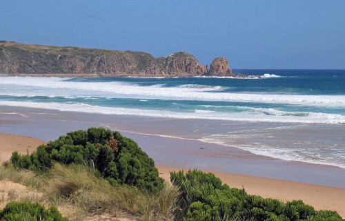
Phillip Island
CCL: https://tinyurl.com/ysjddhbz
Phillip Island Facts
- Next up in this compilation of 5 Intriguing Islands of Australia we present you with the marvel best known as Phillip Island.
- This magnificent creation of Nature and geological forces most frequently goes by the deceptively simple name we’re using. The amazing site previously held several other titles, though. These earlier monikers included the epithets Snapper Island and Grant Island.
- The local population of Indigenous People long knew of its existence, of course. Archaeological evidence indicates that members of the Bunurong people found it first. However, how long they knew of, and made use of the stunning location remains unknown.
- But, the first known European sighting of the magnificent formation only occurred in the year 1798. At that time, the British explorers Matthew Flinders and George Bass explored certain parts of the island. Following that, sealers frequently made use of the beautiful site.
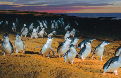
- Today, the visually appealing Phillip Island serves as a locally important tourist destination. That’s true since an average of 3.5 million people currently visit the marvel yearly. It’s best known for its amazing annual event known as the penguin parade, when many come ashore.
- Its extreme popularity understandably complicates efforts to maintain the pristine conditions of the formation, though. Nevertheless, the local authorities make efforts to this end. These include such actions as setting part of the island aside as the Phillip Island Nature Park.

CCL: https://tinyurl.com/bdes27an
Phillip Island Physical Description
The truly breathtaking Phillip Island almost immediately captivates those numerous fortunate visitors flocking to the site. The product of natural forces does not do so due to sheer size, however. That’s because, in this specific respect, it’s actually a moderately small formation of its type.
Yet Nature repeatedly proves that it cares nothing for such qualifications. Just as some of the most beautiful forms of life on the planet remain small in size, the same holds ture for many of its geological marvels. This location itself serves to strongly reinforce that fact in the minds of many.
While highly irregular in terms of its shape, its overall structure very roughly forms a rectangular pattern. The fascinating island also measures approximately 16 mi (25.7 km) in length, but only 5.6 mi (9 km) in general width. It does have several highly protruding, leg-shaped sections, though.
Its extremely irregular outlines also serve to provide the stunning Phillip Island with yet another surprising dimension. That’s true since, given its winding structure, the coastline actually totals a relatively impressive 60 mi (96.6 km). It further boasts a total area of roughly 39 sq mi (101 sq km).
Despite its other aspects, though, one particluar one surprises most people. That’s due to the fact that the site’s also relatively quite flat in nature. In fact, the highest point on the entire island only reaches 360 ft (110 m) above sea level. The landscape mainly consists of small hills and flat areas.
CCL: https://tinyurl.com/22y23f9m
Phillip Island Location, Formation, and Ecology
The gorgeous Phillip Island formed in a region of the world already well known for teeming with both biological and geological wonders. Given that seemingly bold statement, the precise area of the globe in which this breathtaking structure exists lies likely won’t surprise very many people.
That’s due to the fact that this geological gem formed in the zone of the world that lies quite close to the remarkable continent of Australia. More precisely, however, it lies roughly 78 mi (125.6 mi) south-southeast of the city of Melbourne. It thus forms a natural breakwater in the area.
This mesmerizing structure originally formed due to volcanic activity in the immediate region. The earliest origins of the site, in fact, reach back as far as approximately 500 million years! At that time, though, the site still remained beneath the surface of the sea. But then volcanic activity began.
This ation, in fact, repeated countless times throughout the ages, until comparatively recently. Research indicates that its present formation occurred during a period that extended from roughly between 3.2 – 2.3 million years ago. The extended actions deposited multiple layers of basalt.
Today, the astounding Phillip Island hosts an abundant variety of life, within differing ecosystems. That’s partly due to the moderate climate present throughout much of the year. This primarily consists of relatively cool summers combined with markedly mild winters for its zone of the earth.
A documented total of 80 species of flora exist on the island, with different types of grasses and shrubs predominating. Mammals, such as kangaroos and wallabies also appear in large numbers. Numerous avian species also reside here, including, amazingly, a small variety of penguin!
Ball’s Pyramid
CCL: https://bit.ly/2U88ISI
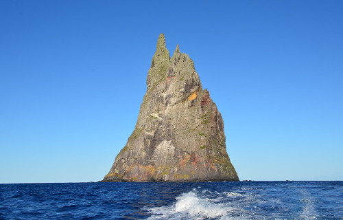
Ball’s Pyramid Facts
- Our next choice for inclusion in this listing of these 5 Intriguing Islands of Australia bears the somewhat descriptive name of Ball’s Pyramid.
- This astounding geological formation, jutting magnificently up from beneath the surface of the ocean, bears the simple name for good reason. This breathtaking landform further holds a place of great honor among the similar works of Nature found around the world.
- That holds true because the amazing site ranks as the tallest formation of its kind known to man. The local government thus accorded it a special place in their culture, due to this fact. The unique site now forms part of a protected area named the Lord Howe Island Marine Park.
- Presently, it’s still unknown if ancient mariners ever glimpsed this masterpiece of natural processes. The first recorded sighting of it, though, took place 1788. Its name pays homage to the first known person to spot it, Lieutenant Henry Lidgbird Ball, who made that sighting.
- This marvelous work of geological forces also shares a common fact with yet another remarkable landform. That’s because the very same intrepid officer also, for the first time in recorded history, discovered the fascinating formation now known as Lord Howe Island.
- Multiple attempts to scale the precarious heights of Ball’s Pyramid failed, until one finally succeeded in 1965. That team of four Australian climbers included Bryden Allen, John Davis, Jack Pettigrew, and David Witham. Several other attempts to climb it followed in later years.
- In the year 1982, however, the government of the region banned all such attempts. Then later, in 1986, the government subsequently banned all access to the site. But, in 1990, the leaders relaxed that restriction, to allow limited attempts. Doing so now requires an official permit.

CCL: https://bit.ly/3hcoung
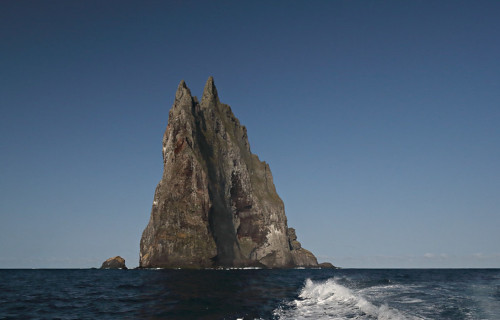
Ball’s Pyramid Physical Description
Certainly, the stark yet undeniably stunning Ball’s Pyramid, of aspecific type known as a stack, merits full appreciation. It does so, however, due to a combination of several unique statistics. The combination of these makes for a remarkable, not to mention, hard to believe, recounting.
For starters, the site juts sharply up from the surrounding sea, standing a respectable 1,844 ft (562 m) tall. Yet that statistic alone doesn’t serve to distinguish it from countless other sites around the world. Indeed, countless others reach far greater heights, relative to the surrounding waters.
The mesemric feature stands out, however, due to the sheer steepness of its slopes. At the point where it meets the water, it measures a mere 3,609 ft (1,100 m) in length. Its recorded width, though, only reaches a scant 984 ft (300 m) across at its widest point at any spot along its entire length.
Those measurements lend the awe-inspiring monolith men named Ball’s Pyramid a sharply triangular shape. Its steep sides also possess very few breaks or ledges to mar the otherwise relatively smooth surface. The combination creates a starkly beautiful, if mostly vertical, landscape.
CCL: https://bit.ly/2U88ISI
Ball’s Pyramid Location, Formation, and Ecology
Part of the reason why the incredible Ball’s Pyramid wasn’t discovered, to our knowledge, at least, until the 18th century, occurs due to its location on the earth’s surface. That’s because this wonder formed in a comparatively remote part of the ocean, situated in the Southern Hemisphere.
More precisely, though, this marvel of Nature and natural processes lies roughly 12 mi (20 km) from Lord Howe Island. That further places it approximately 400 mi (643.7 km) northeast of Sydney, Australia. The island, and the local region, presently forms a possession of that country.
To no great surprise for those possessing an understanding of geology, the site also has a volcanic origin. Specifically, it represents what’s known as an erosional remnant, due to the actions of the surrounding waves. It originally formed part of the caldera of what’s known as a shield volcano.
Evidence uncovered by researchers indicates that the original volcano formed sometime around 6.4 million years ago. Intriguingly, this impressive site itself actually forms part of the submerged continent named Zealandia. It’s now positioned roughly in the center of a submarine shelf.
Given the extremely harsh local environmental conditions, very little life inhabits the magnificent Ball’s Pyramid. Yet, the resourcefulness of Nature cannot be overlooked. Scant vegetation clings to the rocks there, however, struggling to surive in the harsh and inhospitable environment.
That scarce vegetation principally consists of a very small variety of grasses, mosses, and lichens. A limited population of small shrubs also appear, though, marginally eking out their survival. These plants mainly consist of a single species in the Myrtle family, endemic to the surrounding region.
Occasionally, however, a few seabirds choose to make their nests on the imposing site. Several locally numerous species make use of its special geography in this way for their purposes. That’s due to the understandable fact that the steep walls provide a refuge for the raising of the young.
Astonishingly, though, only a single known species of insect makes its home on the island. That’s because a tiny population of the awesome Lord Howe Island Stick Insect lives there. The entire known population, however, consists of only a few dozen specimens, living under a single bush!
Fraser Island
Fraser Island Facts
- Now appearing in this compendium of 5 Intriguing Islands of Australia we present you with the marvelous site known as Fraser Island.
- This breathtaking geological formation, holding numerous natural wonders, remains most widely known by the english name given here. Yet it’s also known by at least a few other terms. Those stem from the languages of two originally present Indigenous Peoples.
- One of those terms, that of K’gari, therefore, comes from the language of the Butchalla aborignes. In the mother tongue of the Badtjala people, however, it’s known by the even shorter term of Gari. Regardless of the name one uses, though, it’s an incredible natural marvel.
- Archaeological evidence indicates that local populations appeared on the island at least 5,000 years ago. In more recent times, though, outsiders did not discover the natural wonder until the British explorer James Cook sighted it in 1770. But he did not land on it at that time.
- The first historically recorded non-native presence on the island occurred in 1802. That’s because, at that time, the lesser-known British explorer, Matthew Flinders, landed at roughly the most northerly point of the site. Thereafter, it briefly bore the name Great Sandy Island.
- Thankfully, the incredible beauty of Fraser Island garnered it great appreciation by many people and groups, including UNESCO. Due to that, the organization named it a World Heritage Site, in 1992. This further led to its renaming to the aboriginal name of K’gari, in 2021.
- Though it’s understandably a popular tourist destination, the island does have a measure of protection. This holds true due to the fact that it now forms part of the Great Sandy National Park. Measures thus remain in place to monitor and protect it from human depredations.
CCL: https://bit.ly/3rhh0G1
Fraser Island Physical Description
The magnificent Fraser Island fully merits appreciation for its vast natural wonders. It further does so for not merely one, but several reasons. Though certainly not its greatest attraction by far, the sheer size of the site nonetheless deserves much respect and mention in any article dealing with it.
That’s because it somewhat surprisingly boasts an impressive total area. More precisely, this equals roughly 710 sq mi (1,840 sq km). Its overall shape, however, garners some notice from those who visit the site. In fact, the location has a roughly, though highly elongated, general shape.
Though its outline understandably remains highly irregular in general shape, some approximations can nevertheless be made. Regarding these statistics, the stunning island measures roughly 76 mi (123 km) in length. Overall, though, its width actually only measures about 14 mi (22 km).
Yet this creation of geology also stands out for another reason. That’s true since it ranks as the largest of all islands of its type, known as sand islands. As the term implies, such islands have a composition composed primarily of sand. This nature alone distinguishes it from many others.
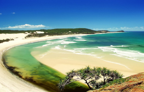
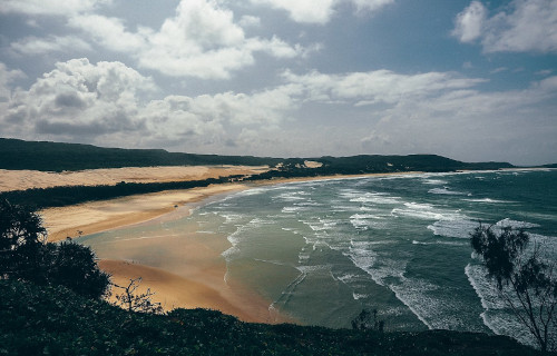
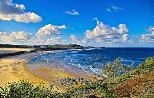
Its wonders only become even more impressive from there, however. Nature, along with time, truly outdid itself in its creation. Despite its relatively large sand component, the amazing Fraser Island also boasts numerous geological features that might surprise some individuals with their presence.
These multiple attractions include numerous free-flowing freshwater creeks, for one. Multiple sand dunes further add to its captivating visual appeal. Astonishingly, it also holds more than 100 lakes! These additionally hold some of the cleanest naturally occurring freshwater known to man.
CCL: https://bit.ly/3KXDBPp
Fraser Island Location, Formation, and Ecology
The awe-inspiring structure still best known as Fraser Island even holds one more intriguing statistic to amaze us. It formed in a part of the world already well known for its extreme abundance of natural marvels. That’s because it lies just off the coast of the gorgeous continent of Australia.
More precisely, the awesome site formed off the eastern coast of the landmass. However, the extremely elongated island additionally varies in proximity to the continent. Part of it lies relatively close to the shore, and roughly parallels it. Another section, though, angles sharply away from it.
This marvel of geology apparently began its inexorable formation around 750,000 years ago. At that time, sand began to routinely accumulate on volcanic bedrock. Over time, a strong offshore current carried prodigious quantities of this northward, along the coastline of the nearby continent.
Despite its largely sand-based composition, the island boasts an extremely rich and highly diverse ecosystem. That’s due to the presence of a naturally occuring mycorrhizal fungi present in the sand. This naturally releases nutrients into the sand otherwise absent, allowing life to flourish.
Due to the unique circumstances present on Fraser Island, an astonishing 865 known species of flora appear within its boundaries. Adding to its distinction is the fact that it’s the only place on the planet where a large rainforest grows in sand. What amazing wonders lie within its boundaries!
Mammalian species also appear, numbering an estimated 25 – 50. These include the Swamp Wallaby and Bandicoots, among others. A known total of 74 species of reptiles additionally reside here, including 18 recognized types of snakes. An amazing 350 known species of birds also live here.
Christmas Island

CCL: https://bit.ly/2RyD3Gy
Christmas Island Facts
- Closing out this article about these 5 Intriguing Islands of Australia comes the festively-named location known as Christmas Island.
- The highly charismatic name it’s known by serves as the most frequently used common name for this true wonder of natural processes. Yet, it also holds a few other titles by which it’s known. These include Island of the Red Crabs, Pulau Natal, and even Flying Fish Cove.
- Much like many other such formations found across the world, this wonder possesses a somewhat storied history. For the moment, however, it remains undetermined by either modern historians or archaeologists if ancient humans ever used or even knew of the location.
- The first recorded sighting of the island, though, occurred in the year 1615. At that time, Richard Rowe of the ship Thomas reported spotting the site. However, Captain William Mynors later named the island in honor of the day that he first encountered it, Christmas Day, 1643.
- Fortunately for history, the unique combination of its relative isolation and an apparently minimal human interference benefited its local ecology immensely. Due to these factors, much of its native flora and fauna, some of it entirely unique to the island, still remains intact.
- Great efforts have been taken by both groups and organizations to preserve these endemic species. That same effort continues to this day, as well. These efforts have been largely successful, despite a history of phosphate mining on an isolated section of Christmas Island.
- In fact, a total of 63% of the stunning island presently comprises the aptly-named Christmas Island National Park. This provides a certain measure of protection from the depredations of man. Nonetheless, it behooves us to be highly vigilant in our efforts to preserve the site.
CCL: https://bit.ly/2DWgeEN
Christmas Island Physical Description
Regardless of its unquestioned visual distinctiveness, Christmas Island nevertheless is a physically small location. The highly irregularly shaped island only possesses a total area of roughly 52 sq mi (135 sq km). Its unique shape covers an impressive total of 86.3 mi (138.9 km) of coastline.
Astoundingly, the entire island actually comprises the roughly flat summit of an undersea volcano. The total height of this huge mountain equals about 14,800 ft (4,500 m). But the highest measured point on this marvel of geology itself only reaches approximately 1,184 ft (361 m) above sea level.
Given that the beautiful site originally formed as a volcano, areas of basalt still lie exposed in places. The majority of the surface rock, though, actually consists of limestone. This surface area itself actually represents an enormous accumulation of coral due to extreme long-term growth.
Extremely steep cliffs also line much of the coastline of Christmas Island. These formations, in turn, give way to a largely central plateau. Outward, a narrow, but nevertheless quite dangerous coral reef surrounds virtually the entire island. This natural feature often poses a severe hazard to ships.
CCL: https://bit.ly/2saGdG4
Christmas Island Location, Climate, Flora, and Fauna
This mind-boggling beauty named Christmas Island formed in a region of the surface of the earth that surprises many people. The precise location of that creation actually places it in comparative proximity to an equally remarkable larger landmass. That’s the amazing continent of Australia.
More precisely, though, this product of long-term natural actions lies situated roughly 960 mi (1,550 km) northwest of the closest point of the mainland of the above-mentioned mainland. That setting places it inside the Indian Ocean, roughly about 220 mi (350 km) south of Sumatra and Java.
Because it formed in close proximity to the southern edge of the equatorial region, this island quite understandably boasts a predominantly tropical climate. As a direct result of this intriguing fact, the temperature on the island rarely varies more than a few degrees throughout the entire year.
Typically, this ranges from somewhere between 73 – 84 F (23 – 29 C). But the local wet season often brings torrential monsoon rains. Much of the island also boasts a rather dense covering of tropical rainforest. A total of 25 species of tree dominate much of this, with a smattering of other species.
Numerous types of flora, mainly including ferns, vines, and dazzling orchids also bloom in the area. Of the currently 135 identified plant species, 18 appear nowhere else on earth. The site also serves as home to an equally wide variety of fauna. This includes various types of bats, rats, and shrews.
Some of these forms of life seem to live nowhere else on earth. Sadly, a few of these have not been seen in many years, and may already be completely extinct. The most prevalent fauna of Christmas Island consists of the various seabirds and crabs, including the truly impressive Coconut Crab.
CCL: https://bit.ly/3hcoung
5 Intriguing Islands of Australia
We hope that each of you thoroughly enjoyed reading, and hopefully learning something from, this article we’ve written about these 5 Intriguing Islands of Australia. It’s also our hope that doing so has left you with either a new or renewed appreciation for such amazing wonders of Nature.
Unfortunately, many other such features located around the world now find themselves facing severe threats to their continued existence in an undamaged state. Many of those dangers, in fact, stem from the actions of mankind. We must do all we can to protect and preserve them all.
Check out our other articles on 5 Magnificent Mountains of Europe, Wonderful Wild Cats of the World, 7 Stunning Atlantic Ocean Sharks, Earth’s Geothermal Marvels, 5 Fantastic Fauna of Tunisia
Leave a Reply