


CCL: https://bit.ly/3Ad8z0O
7 Spellbinding African Marvels
Our choices for 7 Spellbinding African Marvels follow. To be certain, any such list remains entirely subjective, because criteria vary by personal opinion. But we here at Our Breathing Planet respect and admire the beauty of our world wherever it is found.
We also encourage everyone to do likewise and do everything within our collective power to protect and preserve these marvel for future generations.
Breathtaking marvels of Nature exist throughout the world. Yet, the continent of Africa seems to be blessed with more than its fair share of such incredible beauty. In this article, we present to you our choices for inclusion on this list. We hope that you enjoy and appreciate them as much as we do.
Eye of the Sahara
Eye of the Sahara Facts
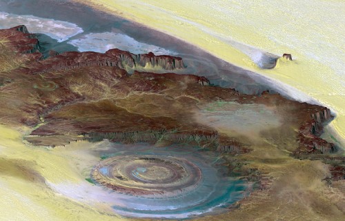
- The Eye of the Sahara ranks as one of the most incredible geological marvels of our world. This phenomenal site sits in the Sahara Desert in western Mauritania, in Africa.
- This extraordinary geological feature was actually unknown until it was accidentally spotted from space. Between its extreme remoteness and its sheer size, no one noticed its uniqueness, even when passing through it.
- While competing theories concerning its origins exist, the debate still rages among some scientists. Nature seems reluctant to yield its mysteries to mankind.
Eye of the Sahara Physical Description
Evidence indicates that the astonishing Eye of the Sahara represents the remnants of a geologic dome that formed approximately 100 million years ago.
It has a rough diameter of 25 mi (40 km). Actually consisting of several concentric rings, the largest, the central area, measures roughly 19 mi (30 km) in diameter.
A wide variety of rock structures appears in the various sections of the Eye, such as volcanic rocks, gabbros, carbonatites, and kimberlites.
Numerous hydrothermal features also exist within the site. These include formations consisting of sandstone, silica, and limestone.
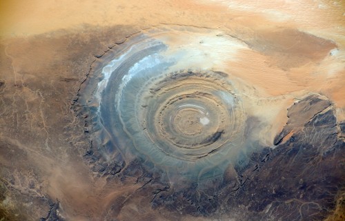
Eye of the Sahara Mysterious Origins
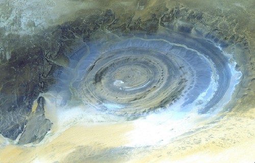
Local people believed that the remarkable Eye of the Sahara was originally the result of a large meteor strike in ages past, but scientific studies have recently disproved that theory.
Also, different types of rock structures make up each of the separate rings. Scientists still have no definitive explanation for that rather surprising fact either.
The truly astonishing site actually remains visible from orbit. Scientists now believe it most likely is the result of the effects of uplift and erosion, although geologists admit that they are not certain about that. The cause of its circular shape remains a mystery.
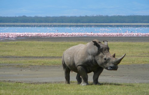
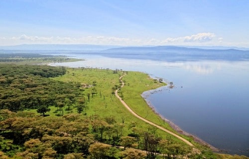
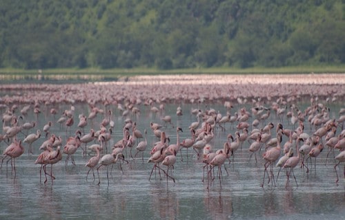
Lake Nakuru
CCL: https://bit.ly/3DaaxAD
Lake Nakuru Facts
- Lake Nakuru forms one of a rather unique group of lakes, also collectively known as the Rift Valley Soda Lakes.
- This picturesque lake also sits in an area of rugged beauty in the rift valley of Kenya, in Africa.
- The lake also forms part of Lake Nakuru National Park, an astonishingly beautiful haven for wildlife, including many threatened species.
- The beauty and importance of this incredible site led to its being protected under the Ramsar Convention on wetlands.
CCL: https://bit.ly/1p2b8Ke
Lake Nakuru Physical Description
The breathtaking Lake Nakuru also represents one of the most beautiful soda lakes in the world. It sits at an altitude of roughly 5,755 ft (1,754 m) above sea level.
The surface area of the lake varies dramatically, according to the seasons. As a result, its diameter varies between 2-18 sq mi (5-45 sq km).
The unique chemistry of the lake, the warm alkaline water, allows for the growth of prodigious quantities of algae. This, in turn, also draws enormous numbers of flamingos and other wildlife.
CCL: https://bit.ly/1jxQJMa
Lake Nakuru Habitat and Wildlife
Lake Nakuru remains extremely famous for its avian spectacle. More than 400 species of birds call this marvel of geology and the surrounding park home. Chief among these are two types of the pink flamingo.
At times, as many as 2 million of these birds stay on the lake at one time. What an incredible photo opportunity this must be.
The lake and surrounding park are also home to a myriad of animal species such as a population of both highly endangered black rhino and white rhinos.
Such a concentration of wildlife also draws numerous predators, as well. These include cheetahs, lions, and leopards.
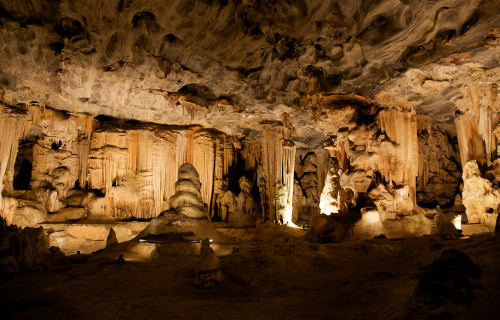
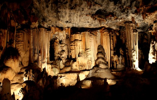
Cango Caves
CCL: https://bit.ly/2UI96aD
Cango Caves Facts
- Many people consider the most noteworthy fact about the Cango Caves to be their status as the most extensive and best known geological marvel of its kind found anywhere in the region.
- This complex of caves and tunnels also happens to be extremely old. The limestone in which they appear formed during the Precambrian Period, and the caves and tunnels formed approximately 20 million years ago.
- The site remains one of the most popular tourist sites in the region, yet tourists can only access approximately one-fourth of their extent. In addition, tourists can only enter the complex as part of a supervised group.
- The utilization of the Cango Caves began long ago. Stone artifacts found within the caves indicate that primitive man used them for shelter in both the Middle and Late Stone Age.
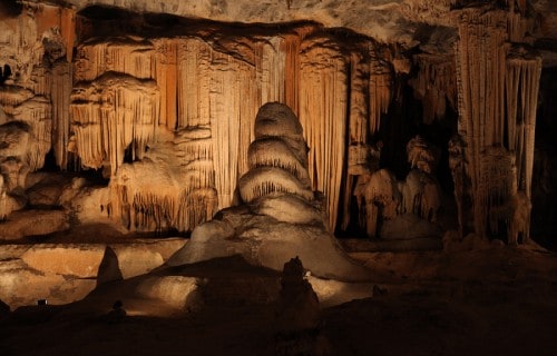
Cango Caves Physical Description
The remarkable Cango Caves consist of a series of an extensive series of hidden chambers and connecting tunnels. While only a portion remains accessible by the public, the entire system extends for approximately 2.5 mi (4 km).
Numerous large chambers connected by twisting tunnels contain marvelous sights and experiences. The chambers vary in size, yet the largest measures approximately 984 ft (300 m) in length.
The deepest section of the complex also lies an equal distance beneath the surface. In addition, thousands of stalagmites and stalactites fill the various chambers.
Also, the surrounding rock primarily consists of ancient limestone. A small underground river also flows through some of the chambers and tunnels.
Cango Caves Location, Formation and Exploration
The magnificent Cango Caves formed in what now constitutes the country of South Africa. The nearest town sits approximately 10 mi (16 km) away.
This complex originally formed as a series of dripstone caverns and lies in a limestone ridge running parallel to the Swartberg Mountains. The first recorded discovery of the complex in modern times occurred in 1780, yet archaeological evidence places human usage of the site as far back as nearly 300,000 years ago.
The first known attempt to map the system occurred in 1897. In addition, the first scientific mapping of the complex was carried out by the South African Speleological Association, in 1956. It also remains important to note that there may be more to the complex than we currently know, as portions of it still lie under water.
It also remains important to note that there may be more to the complex than we currently know, as portions of it still lie under water.
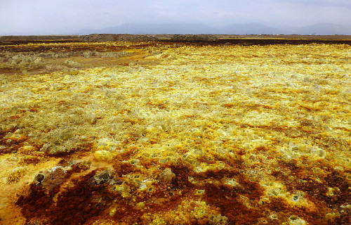
Dallol Hydrothermal Field
CCL: https://bit.ly/3Ad8z0O
Dallol Hydrothermal Field Facts
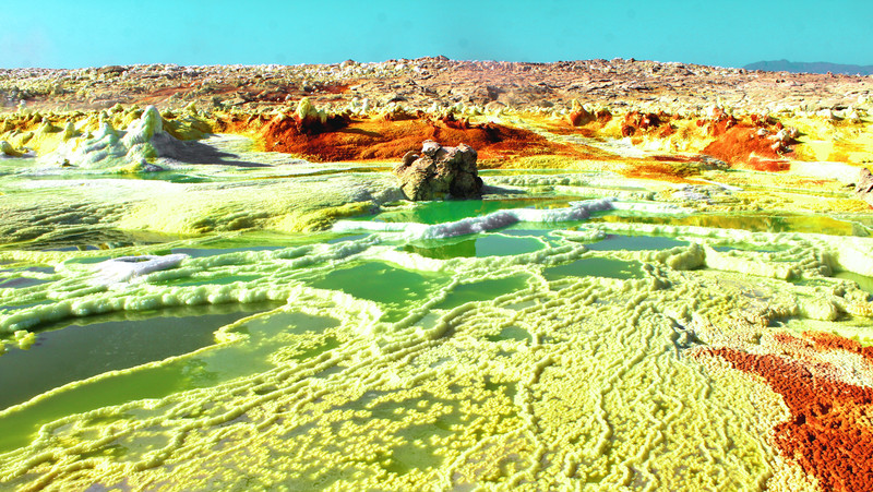
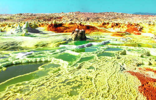
- The breathtaking Dallol Hydrothermal Field represents an incredible wonder of geology that formed in a rather isolated and remote part of the world.
- The field officially ranks as the lowest known subaerial volcanic region on earth. From the perspective of uniqueness, it remains one of the world’s most spectacular landscapes.
- This astonishing location also ranks as one of the hottest and driest locations on the planet. This simply serves to augment the enhance the uniqueness of the landscape.
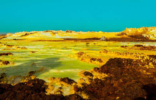
Dallol Hydrothermal Field Description
In terms of overall average temperatures, the remarkable Dallol Hydrothermal Field represents one of the hottest location in the world that scientists currently know of.
In fact, the mean annual temperature is approximately 86 F (30 C).
The central feature of the site remains the Dallol volcano which has a rather broad shape and averages about 1 mi (1.6 km) in width.
However, it measures quite low, measuring roughly 164 ft (50 m) in height.
The surrounding region has numerous associated geological features, such as hot springs, brine pools, multicolored sand deposits, miniature geysers, and even acid pools.
CCL: https://bit.ly/2SBqk8X
Dallol Hydrothermal Field Location and Geology
The mind-blowing Dallol Hydrothermal Field formed in the northern Danakil Depression in what now constitutes Ethiopia, in Africa.
This amazing formation sits at an astonishing 269 ft (82 m) below sea level.
This site comprises a rather expansive region of uplifted and quite thick salt deposits which intense fumarolic activity continuously affects.
Geologists believe that the presence of an active volcanic system beneath several miles of salt deposits perhaps serves as the major culprit.
The most recent of the many craters formed in 1926, as the result of a type of volcanic event known as a phreatic eruption.
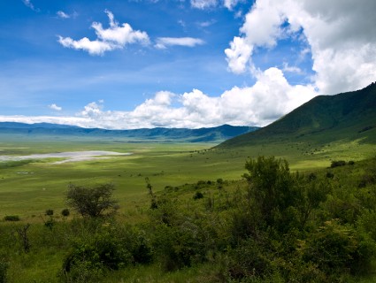
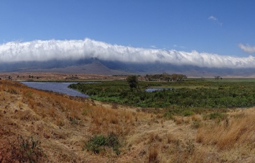
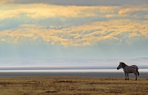
Ngorongoro Crater
CCL: https://bit.ly/1ryPA8o
Ngorongoro Crater Facts
- Ngorongoro Crater represents the largest inactive, intact, and unfilled volcanic caldera on earth. It sits in Tanzania, in Africa and also forms the remnants of a volcano that exploded violently between 2-3 million years ago.
- The volcano measures about 2,000 ft (610 m) deep, and its floor covers an area of 100 square mi (260 sq. km).
- The crater floor sits at 5,900 ft (1,800 m) above sea level and the crater walls serve as home to a combination of montane forests, grasslands, and bushlands. The floor of the crater primarily constitutes open grassland.
CCL: https://bit.ly/1p2b8Ke
Ngorongoro Crater Wildlife
A rather large salt lake sits in the middle of the impressive Ngorongoro Crater. Many species live within the crater, including black rhinos, hippos, and wildebeests.
Additionally, large numbers of bird species including flamingo love to visit the lake. Some of these species, like the wildebeest, migrate out of the crater during the wet season. Yet others, like East African lions, also known as crater lions, reside there year round.
In fact, this beautiful site also serves as the permanent home of the largest known population of the East African lions.
In total, roughly 25,000 large animals call this remarkable site their home.
CCL: https://bit.ly/1p2b8Ke
Ngorongoro Crater Preservation
The magnificent and breathtaking Ngorongoro Crater serves as part of the Ngorongoro Conservation Area. In fact, this entire marvel of geology is a UNESCO World Heritage Site.
Unfortunately, in the year 2000, a severe drought heavily damaged the plant life, and many of the herds of animals thinned greatly in numbers. Since then, they have thankfully steadily recovered.
Efforts to preserve the ecosystem within the crater remain ongoing and include controlled burns of the grasslands.
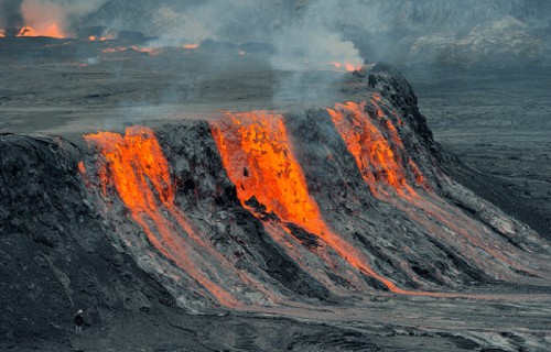
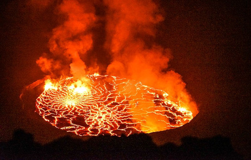
Nyiragongo Volcano
Nyiragongo Volcano Facts
- The Nyiragongo Volcano presents a quite unique combination of factors for vulcanologists to study. Investigations of this geological marvel keep geologists rather busy.
- While the volume of its lava lake varies, the average amount of lava it contains makes it the largest regularly maintained lava lake in the world.
- The lava produced by this volcano also has an extremely fluid consistency. This is because it contains an unusually high concentration of alkali-rich volcanic rock.
- Incidentally, it possesses a relatively steep slope. Combined with the fluid consistency of its lava and its proximity to populated areas, this makes it a dangerous volcano.
Nyiragongo Volcano Geological Description
The Nyiragongo Volcano represents an excellent example of a stratovolcano. It also remains highly (and almost constantly) active.
It also stands quite tall, with a height of 11,380 ft (3,470 m). In addition, the primary crater measures almost 1.25 mi (2 km) wide. Its lava lake adds another distinctive characteristic, having an average depth of nearly 2,000 ft ( 600 m).
Yet the nature of its lava remains its most distinctive feature. Possessing an extremely high alkali ratio, the lava flows rather rapidly down its steep slopes. As a result, downhill flow speeds have been measured at 60 mph (100 kph).
Due to its combination of slope and lava fluidity, its flow speeds represent the fastest currently known to man.
Nyiragongo Volcano Location and History
The Nyiragongo Volcano sits in the Virunga National Park, in the Democratic Republic of the Congo. This location places it less than 12 mi (20 km) from a populated area.
Vulcanologists know little of its ancient eruptive history, yet its activity in modern times remains well documented. The volcano has erupted 34 times since 1882. Furthermore, some of these eruptions lasted for years at a time.
This volcano overlaps with several older volcanoes and sits amid hundreds of small cinder cones. Because of its unique dangers, the Nyiragongo Volcano was named as a Decade Volcano in 1991.
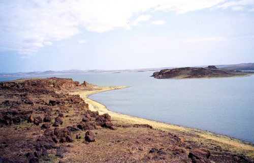
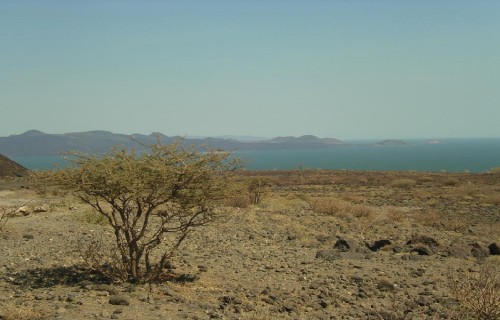
Lake Turkana
Lake Turkana Facts
- The remarkable Lake Turkana remains the largest known permanent desert lake on Earth. It also holds recognition for being the world’s largest alkaline lake.
- By volume, it also ranks as the world’s fourth largest salt lake. Technically, you can drink the water safely, but few consider it palatable.
- Sadly, the lake now faces a threat from human actions. While currently under construction, the Gilgel Gibe lll dam will once completed, block the river that provides most of the water for the lake.
- The nature of the lake creates locally intense weather effects. Violent storms frequently arise in the immediate vicinity of the site.
CCL: https://bit.ly/1p2b8Ke
Lake Turkana Physical Description
Located almost precisely in the center of the rather surprising Lake Turkana sits a volcanic island. The discoverers aptly named it Central Island.
It still ranks as an active volcano, continuously emitting vapors.
Three separate rivers also flow into the lake, although they have no outlet. The only water loss occurs due to evaporation in the arid climate.
It also has a maximum length of roughly 180 mi (290 km) and a maximum width of about 20 mi (32 km).
This wonder of geology remains remarkable for a variety of reasons.
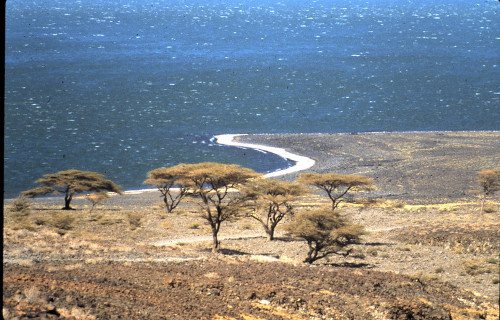
Lake Turkana Location and Ecology
The impressive Lake Turkana forms an extremely large lake located primarily in Kenya, in Africa. However, a small portion of it also crosses into Ethiopia.
Due to inaccessibility, temperature, and aridity, Lake Turkana continues to retain its wild character. Nile crocodiles inhabit the lake in abundance, and scorpions and carpet vipers live in numerous around the shores.
Even though three separate rivers flow into the lake, none of them exit. The only water loss occurs via evaporation. However, given the aridity of the surrounding climate, this loss can be extreme at times.
Illustrating this perfectly, was the dramatic drop in water level between 1975 and 1993. During this period, the overall level dropped a dramatic 33 ft (10 m).
The astonishing site was recently named a World Heritage Site by UNESCO.
CCL: https://bit.ly/3Ad8z0O
7 Spellbinding African Marvels
These incredible wonders of Nature that we have presented to you represent only our personal choices to represent 7 Spellbinding African Marvels.
To be certain, innumerable others remain. In addition, the breathtaking majesty of Nature’s beauty is by no means limited to this area of our gorgeous world.

Please check out some of our articles on other natural marvels, both in Africa and beyond.
Erg Chebbi, Fly Geyser, Mount Erebus, Er Wang Dong, Whitehaven Beach, Devetashka Cave, Fernando de Noronha